Showing 3448 items
matching road bridges
-
 Eltham District Historical Society Inc
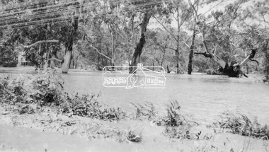
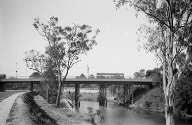
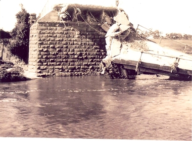
Negative - Photograph, Floodwaters, Diamond Creek, Eltham, 1934
... The Diamond Creek in flood near the Main Road bridge... melbourne The Diamond Creek in flood near the Main Road bridge ...The Diamond Creek in flood near the Main Road bridge at Eltham, Victoria. The Yarra also was in flood. In early December 1934 the "Greatest flood in the history of the Yarra" occured, according to The Argus newspaper. Bridges and houses were swept away with hundreds of people left homeless across the state. The historic 1934 flood of the Diamond Creek and Yarra River set the criteria for future planning with respect to flood water rise. Noted on reverse of print - Copied by Hugh Fisher, 82 Lygon St., BrunswickThis photo forms part of a collection of photographs gathered by the Shire of Eltham for their centenary project book,"Pioneers and Painters: 100 years of the Shire of Eltham" by Alan Marshall (1971). The collection of over 500 images is held in partnership between Eltham District Historical Society and Yarra Plenty Regional Library (Eltham Library) and is now formally known as the 'The Shire of Eltham Pioneers Photograph Collection.' It is significant in being the first community sourced collection representing the places and people of the Shire's first one hundred years.Digital image 4 x 5 inch B&W Neg (2 frames on one neg) Print 9 x 15.5 cmOn reverse of print - "Copied by Hugh Fisher, 82 Lygon St., Brunswick" (for Shire of Eltham)sepp, shire of eltham pioneers photograph collection, eltham, floods, 1934 flood, diamond creek (creek), floodwater -
 Melbourne Tram Museum
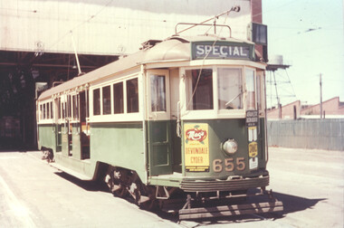
Photograph - Set of five colour prints - last day of Footscary - AETA tour, 10/2/1962
... followed by W3 655 crossing the Maribyrnong Road Bridge. 4... followed by W3 655 crossing the Maribyrnong Road Bridge. 4 ...Colour prints show the trams used by the AETA (Australian Electric Traction Association) on 10/2/1962 to mark the closure of the local routes at Footscray. 1 - W3 655 at South Melbourne depot 2 - W3 655 shunting at Moonee Ponds Junction 3 - W4 670 followed by W3 655 crossing the Maribyrnong Road Bridge. 4 - The two trams at Footscray Station 5 - At Footscray tram depot with local cars. See item 3992 for other photographs. Yields information about the AETA tour to mark the closure of the Footscray local system. Set of five Colour print on Kodak Royal paper.trams, tramways, w3 class, w4 class, tram 655, tram 670, footscray, maribyrnong road, moonee ponds junction, south melbourne depot, footscray depot, leeds st, aeta -
 Melbourne Tram Museum
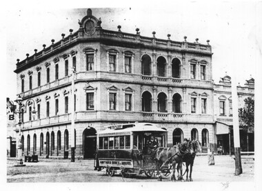
Photograph - Horse Tram 30 Riversdale Hotel, c1900
... at Auburn Road to Richmond (Hawthorn Bridge) where it will connect... at Auburn Road to Richmond (Hawthorn Bridge) where it will connect ...Photograph shows MTOCo horse tram No. 30 in Riversdale Road at Auburn Road to Richmond (Hawthorn Bridge) where it will connect with the Bridge Road cable tram. In the background is the Riversdale Hotel. Photo c1900 from the CB Thomas collection.Yields information about the Riversdale Road Hawthorn horse tramway.Black and white photograph with notes on rear.In ink "1" and "K McC"tramcars, tramways, horse tram, tram 30, riversdale road, hawthorn -
 Tatura Irrigation & Wartime Camps Museum
Document, Waranga Conservation Study 1988. Volume 1, 1988
... on cover of Rimes farmhouse, Bakers Bridge Road Wanalta c 1874-8.... farmhouse, Bakers Bridge Road Wanalta c 1874-8. Waranga Conservation ...Recommendations and guidelines. A study of historical data on local conservation for Waranga Shores, includes early photos of houses in Murchison and RushworthWhite plastic back, Clear plastic on front. Picture on cover of Rimes farmhouse, Bakers Bridge Road Wanalta c 1874-8. -
 Lakes Entrance Historical Society
Postcard - View of Bruthen, W S Vogt Bairnsdale, 1918 c
... Black and white postcard showing township, roads and rail...Township Bridges Roads and Streets Tambo River at Bruthen ...Black and white postcard showing township, roads and rail, bridges and barked trees with cultivated land beside Tambo River Bruthen VictoriaTambo River at Bruthentownship, bridges, roads and streets -
 Flagstaff Hill Maritime Museum and Village
Document - Navigation Chart, Admiralty Office, Lady Bay and Warrnambool Harbour, 1893
... of Warrnambool Harbour, Lady Bay, the Breakwater and Jetty, roads...), streets, roads, bridges and many buildings. It also shows the lay ...This navigation cart of Lady Bay and Warrnambool Harbour was originally surveyed in 1870 but this version includes the update for magnetic variation in 1893. Since the printing of the chart several annotations have been added. These include an additional stamp dated 15-8-1910, a handwritten comment across the top of the page dated August 1910, and another handwritten comment regarding the ‘Proposed Extension of Dock’ dated 19-2-1925, plus connected drawings, notes and figures. The 1925 proposal on this chart may have been a reaction to the Royal Commission of 1923, when the damaged stonework on the seaward side of the Warrnambool Breakwater, caused by the action of the sea, was the subject of enquiry. A conference between the Public Works, Water Commission and the Harbour Trust concluded that it would less costly to make repairs to prevent further damage rather than replaced the damage portion of the wall. A contract was raised in late 1924 to deposit rubble on the damaged side of the breakwater to minimise the Southern Ocean’s destructive action and work had started by August 1925. The Breakwater construction had begun in 1874 and was completed in 1890. The Victorian Government had commissioned Sir John Coode, a British harbour engineer, to present a plan to complete the Warrnambool Breakwater but his original plan was too expensive. He prepared a revised plan for a shorter structure. The construction proved to be too short to protect adequately from the weather and didn't allow enough depth for larger vessels to come into port. The decreasing trade was further affected by siltation in the bay due to the breakwater, and the completion of the railway line. The situation of the harbour became a real problem by 1910 and required continuous dredging. In 1914 the Breakwater was extended but proved to be a failure because the work began to subside and by 1920 about two thirds of the harbour was silted up. Alterations made in the 1920's increased the silting problem and by the 1940's the harbour was no longer used. More alterations were made in the 1950's and 1960's. This chart is significant for its strong connection to the maritime history of Warrnambool Harbour and Lady Bay and the Warrnambool Breakwater. The Warrnambool Breakwater is registered as a place of significance on the Victorian Heritage Database (VHR H2024). The Warrnambool Breakwater is one of the most important late 19th century maritime engineering projects in Victoria and significant in the development of Victorian coastal shipping. It is also significant for its connection with British harbour engineer, Sir John Coode. The chart is a historical record of structures existing in 1893; the Warrnambool Jetties, Warrnambool Breakwater in Lady Bay, the leading lights (lighthouses), streets, roads, bridges and many buildings. It also shows the lay of the land and seabed. Navigation Chart: Lady Bay and Warrnambool Harbour, Australia - South Coast - Victoria. Surveyed by Nav. Lieut. H.J. Stanley, R.N., 1870. Updated for Magnetic Variation, 1893. The rectangular chart is printed on heavy cream paper. Stamps are shaped rectangular, oval and round. Around the Breakwater and Jetty area are handwritten notes, dotted and joined lines, numbers and signatures, and shading of red and green. The chart shows the surrounds of Warrnambool Harbour, Lady Bay, the Breakwater and Jetty, roads, bridges and the streets in Warrnambool. It has sounding details, and angles of line from the leading lights.Stamp, rectangular, including "AUG 1910" Stamp, double oval " - - - -CHART" Stamp, hand drawn, red circle, with "B" inside Hand written note "22-8-1910 - - - - - of surveying C. Ca - - - request of 15-8-10 [initials] " Notes and lines in red pen, including a grid of sounding numbers: "1300" "1050" "1200" "Possible Extension of Dock" "19-2-25" "Dock Dredged to 20 Ft" Notes and lines in blue pen "Extension of Dock to accommodate vessels drawing 20 Feet" and "Light not visible south of this line" Red dots (4) with yellow highlight at both leading lights, breakwater and jettyflagstaff hill, warrnambool, flagstaff hill maritime museum & village, maritime museum, maritime village, shipwreck coast, map, chart, navigation chart, plan, lady bay, warrnambool harbour, port of warrnambool, breakwater, jetty, pier, dock extension, proposed extension, vhr h2024, 1870, 1893, 1910, 1925, warrnambool town late 1800s, warrnambool streets late 1800s royal commission, 1923, public works, water commission, harbour trust, victorian harbours, sir jon coode -
Kew Historical Society Inc
Archive (Sub-series) - Subject File, Bridges (Kew), 1958-present
... Road Bridge. The file includes original materials relating... Road Bridge. The file includes original materials relating ...Various partiesReference, Research, InformationSecondary Values (KHS Imposed Order)Subject file containing information relating to each of the bridges crossing the Yarra In Kew. The file includes correspondence, photocopied photographs and maps, journal articles, research, and printed ephemera. Bridges referred to and described in the file include Kanes Bridge, Walmer Street Foot Bridge, Johnston Street Bridge, Chandler Bridge, Collins Bridge, Tramway or Zig Zag Bridge, Penny Toll Bridge, Victoria Street Bridge, Burke Road Bridge. The file includes original materials relating to the Victoria Street Bridge Centenary Celebration 1884-1984 -
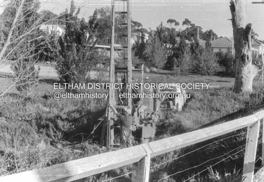 Eltham District Historical Society Inc
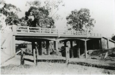
Album - Photograph, J.A. McDonald, Cecil Street Bridge, Eltham-Yarra Glen Road, Eltham, Oct. 1962
... Cecil Street Bridge, Eltham-Yarra Glen Road, Eltham...Eltham-Yarra Glen Road Cecil Street Bridge Looking upstream... melbourne Eltham-Yarra Glen Road Cecil Street Bridge Looking ...Eltham-Yarra Glen Road Cecil Street Bridge Looking upstream Oct. 1962Record of various Shire of Eltham infrastructure works undertaken during the period of 1952-1962 involving bridge and road reconstruction projects, sometimes with Eltham Shire Council Project Reference numbers quoted. It was during this period that a number of significant improvements were made to roads and new bridges constructed within the shire that remain in place as of present day (2022). In many situations, the photos provide a tangible visible record of infrastructure that existed throughout the early days of the Shire. The album was put together by or under the direction of the Shire Engineer, J.A. McDonald.H941 stamped on reverse (film processing #)infrastructure, shire of eltham, bridge construction, road construction, 1962-10, bible street reserve, cecil street bridge, eltham, eltham-yarra glen road, main road -
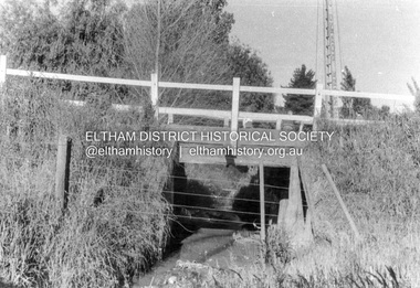 Eltham District Historical Society Inc
Album - Photograph, J.A. McDonald, Cecil Street Bridge, Eltham-Yarra Glen Road, Eltham, Oct. 1962
... Cecil Street Bridge, Eltham-Yarra Glen Road, Eltham...Eltham-Yarra Glen Road Cecil Street Bridge Looking upstream... melbourne Eltham-Yarra Glen Road Cecil Street Bridge Looking ...Eltham-Yarra Glen Road Cecil Street Bridge Looking upstream Oct. 1962Record of various Shire of Eltham infrastructure works undertaken during the period of 1952-1962 involving bridge and road reconstruction projects, sometimes with Eltham Shire Council Project Reference numbers quoted. It was during this period that a number of significant improvements were made to roads and new bridges constructed within the shire that remain in place as of present day (2022). In many situations, the photos provide a tangible visible record of infrastructure that existed throughout the early days of the Shire. The album was put together by or under the direction of the Shire Engineer, J.A. McDonald.H941 stamped on reverse (film processing #)infrastructure, shire of eltham, bridge construction, road construction, 1962-10, cecil street bridge, eltham, eltham-yarra glen road, main road -
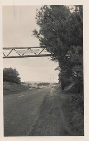 Phillip Island and District Historical Society Inc.
Photograph, 1940's
... Sign across the road before the bridge: Load limit 6 tons... across the road before the bridge: Load limit 6 tons gross ...One of 20 photographs/postcards donated by Mary KarneyBlack & White photograph of roadway to the Bridge from Newhaven side.Sign across the road before the bridge: Load limit 6 tons gross - Speed limit 20 MPHsuspension bridge san remo/phillip island, phillip island suspension bridge, bridges, phillip island, mary karney -
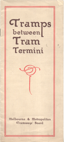 Melbourne Tram Museum
Booklet, Melbourne & Metropolitan Tramways Board (MMTB), "Tramps between tram termini", c1930
... - Gardiner or Glen Iris to Burwood 8 - Wallen Road Bridge... - Gardiner or Glen Iris to Burwood 8 - Wallen Road Bridge ...Booklet - promoting tram travel and walking trips or "tramps" between various tram terminus. Includes notes on the Board's services, its tourist tram with notes and fares on specific walks. Includes a map and some photos for each walk. 1 - Brighton Road to Hawthorn 2 - Burwood to Mont Albert 3 - Carnegie to Darling Road 4 - Whitehorse Road to East Kew 5 - Glen Iris to Darling Road 6 - Maribyrnong River to Mt Alexander Road 7 - Gardiner or Glen Iris to Burwood 8 - Wallen Road Bridge to Glenferrie Road 9 - Johnston St Bridge to Victoria Bridge At the time, some of these walks would have been through largely undeveloped land and parks.Demonstrates a promotion of the MMTB tram services and leisure activities.Booklet - 16 pages, two colours on light fawn paper, centre stapled.tramways, showgrounds, william st, mmtb -
 Melbourne Tram Museum
Negative - Set of 2, Ellis Collection, c1940?
... the Wallen St Road Bridge Hawthorn possibly after the construction... (120) of a wide body car crossing the Wallen St Road Bridge ...Set of two Negatives (120) of a wide body car crossing the Wallen St Road Bridge Hawthorn possibly after the construction of The Boulevard. Taken from either side of the river. Hi Res image filed in the dbtext/hawthtramcoll/Large Images/htd3595aLarge.jpg and htd3595bLarge A low resolution A4 laminated was received with the negatives. Image i2 - taken from Glan Avon Rd in Hawthorn of Wallen Rd bridge – the tram is one of three SW2 class trams (not the first one due to the door sizes, but one of 426, 432 or 478, most probably 478 as that was a Camberwell car)trams, tramways, wallen rd, bridges, sw2 class -
 Stawell Historical Society Inc
Photograph, Concongella Creek Bridge on the Navarre Road
... Concongella Creek Bridge on the Navarre Road...Concongella Creek Bridge Navarre Road... grampians Concongella Creek Bridge Navarre Road Stawell Concongella ...Concongella Creek Bridge Navarre Roadstawell -
 Eltham District Historical Society Inc
Slide, Construction of Eltham Town Park, 22 Feb 1974
... Knox Park. View looking towards the intersection of Main Road... Knox Park. View looking towards the intersection of Main Road ...Construction of Eltham Town Park, later renamed Alistair Knox Park. View looking towards the intersection of Main Road and Bridge Street. The lake body has been formed and young trees planted.35 mm colour positive transparency Mount - Agfacolor Service (Blue)alistair knox park, eltham town park, bridge street, main road -
 Marysville & District Historical Society
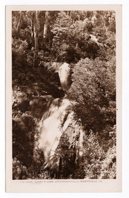
Postcard (item) - Black and white postcard, Rose Stereograph Company, Stevenson Falls, Marysville, Vic, 1913-1967
... of Roads and Bridges, John Steavenson, who arrived in Victoria... after the Victorian Assistant Commissioner of Roads and Bridges ...A postcard in a series produced by the Rose Stereograph Company in Victoria, Australia as a souvenir of Marysville. The Steavenson Falls is named after the Victorian Assistant Commissioner of Roads and Bridges, John Steavenson, who arrived in Victoria in the early 1860s.A black and white photograph of Steavenson Falls, Marysville, Victoria. The Steavenson Falls is named after the Victorian Assistant Commissioner of Roads and Bridges, John Steavenson, who arrived in Victoria in the early 1860s. At 84 metres high, Steavenson Falls is Victoria's tallest cascading waterfall. The falls are split into roughly five cascades, with the last of these plunging into a small, picturesque rock pool. This postcard was produced by the Rose Stereograph Company as a souvenir of Marysville.THE ROSE SERIES P. 10200/ COPYRIGHT/ STEVENSON FALLS, MARYSVILLE, VIC. POST CARD The "Rose" Series/ De Luxe A Real Photograph/ Produced in Australia Published by the Rose Stereograph Co.,/ Sydney and Melbournestevenson falls, marysville, victoria, waterfalls, p. 10200, steavenson falls, rose series postcard, postcard, souvenir, john steavenson -
Tatura Irrigation & Wartime Camps Museum
Document, Waranga Conservation Study. Volume 1, 1988
... on cover of Rimes farmhouse, Bakers Bridge Road, Wanalta C 1874-8.... Picture on cover of Rimes farmhouse, Bakers Bridge Road, Wanalta C ...Recommendations and guidelines. A study of historical data on local conservation for Waranga Shire. Includes early photos of houses in Murchison and RushworthWhite back cover, clear plastic over front cover. Picture on cover of Rimes farmhouse, Bakers Bridge Road, Wanalta C 1874-8waranga shire, documents, reports -
 Federation University Historical Collection
Photograph - Photographs, Richard Vincent, Washed Away Bridge at Garibaldi, c1933
... to bridges and roads damaged by heavy flooding in 1933, in particular... and collapsed bridge/road. .2) mirror image of above .3) unknown man... bridge/road. .2) mirror image of above .3) unknown man waling ...Newspaper clipping documents deputations to the Minister of Public Works for grants to be made available for repairs to bridges and roads damaged by heavy flooding in 1933, in particular, the replacement of a stone and concrete bridge over the Leigh River at Garibaldi in the Buninyong Shire. The concrete slabs were still in the water in the 1960s/70s or even later. Three black and white photographs showing flood damage to the bridge over the Leigh River at Garibaldi, plus a photocopy of a newspaper clipping from The Argus December 1933 describing the extent of the flood damage. .1) shows blue stone buttress and collapsed bridge/road. .2) mirror image of above .3) unknown man waling an a girder of the Garibaldi bridge .4) photocopy of newspaper clipping about flood damage from The Argus December 1933Damage by Floods: Bridges washed away (The Argus December 1933)leigh river, garibaldi, buninyong shire, richard vincent, garibaldi bridge -
 Eltham District Historical Society Inc
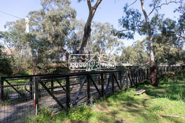
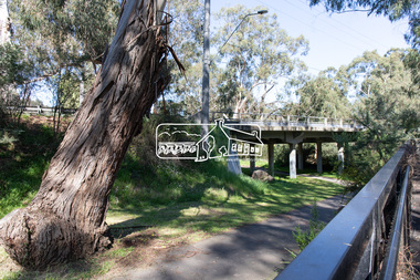
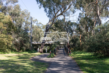
Photograph, Peter Pidgeon, Manna Gum, Main Road Bridge, Eltham South, 8 Sep. 2021
... Manna Gum, Main Road Bridge, Eltham South...main road bridge...This significant tree located near the Main Road Bridge... melbourne This significant tree located near the Main Road Bridge ...This significant tree located near the Main Road Bridge and Diamond Creek Trail footbridge over the Diamond Creek at Eltham dates back to the early 1900s. The original timber bridge over the Diamond Creek was built around 1840. It was destroyed by floodwaters in October 1923. A temporary bridge was rigged up but further damaged in April 1924. A new concrete bridge was built and opened in October 1926. The bridge decking was widened along with Main Road to Dalton Street by the Road Construction Authority in 1984., The uygraded bridge was opened in October 1984, 78 years after its original opening.These trees are not only significant for the natural environment but also present a navigational beacon back in time as the environmental landscape is developed around them.Born Digitaleltham south, main road bridge, manna gum, significant tree, diamond creek trail -
 Eltham District Historical Society Inc
Photograph, Peter Pidgeon, Manna Gum, Main Road Bridge, Eltham South, 8 Sep. 2021
... Manna Gum, Main Road Bridge, Eltham South...main road bridge...This significant tree located near the Main Road Bridge... melbourne This significant tree located near the Main Road Bridge ...This significant tree located near the Main Road Bridge and Diamond Creek Trail footbridge over the Diamond Creek at Eltham dates back to around 1870-1880. The original timber bridge over the Diamond Creek was built around 1840. It was destroyed by floodwaters in October 1923. A temporary bridge was rigged up but further damaged in April 1924. A new concrete bridge was built and opened in October 1926. The bridge decking was widened along with Main Road to Dalton Street by the Road Construction Authority in 1984., The uygraded bridge was opened in October 1984, 78 years after its original opening.These trees are not only significant for the natural environment but also present a navigational beacon back in time as the environmental landscape is developed around them.Born Digitaleltham south, main road bridge, manna gum, significant tree, diamond creek trail -
 Eltham District Historical Society Inc
Photograph, Peter Pidgeon, Manna Gum, Main Road Bridge, Eltham South, 8 Sep. 2021
... Manna Gum, Main Road Bridge, Eltham South...main road bridge...This significant tree located near the Main Road Bridge... melbourne This significant tree located near the Main Road Bridge ...This significant tree located near the Main Road Bridge and Diamond Creek Trail footbridge over the Diamond Creek at Eltham dates back to around 1870-1880. The original timber bridge over the Diamond Creek was built around 1840. It was destroyed by floodwaters in October 1923. A temporary bridge was rigged up but further damaged in April 1924. A new concrete bridge was built and opened in October 1926. The bridge decking was widened along with Main Road to Dalton Street by the Road Construction Authority in 1984., The upgraded bridge was opened in October 1984, 78 years after its original opening.These trees are not only significant for the natural environment but also present a navigational beacon back in time as the environmental landscape is developed around them.Born Digitaleltham south, main road bridge, manna gum, significant tree, diamond creek trail -
 Eltham District Historical Society Inc
Photograph, Peter Pidgeon, Manna Gum, Main Road Bridge, Eltham South, 8 Sep. 2021
... Manna Gum, Main Road Bridge, Eltham South...main road bridge...This significant tree located near the Main Road Bridge... melbourne This significant tree located near the Main Road Bridge ...This significant tree located near the Main Road Bridge and Diamond Creek Trail footbridge over the Diamond Creek at Eltham dates back to the early 1900s. The original timber bridge over the Diamond Creek was built around 1840. It was destroyed by floodwaters in October 1923. A temporary bridge was rigged up but further damaged in April 1924. A new concrete bridge was built and opened in October 1926. The bridge decking was widened along with Main Road to Dalton Street by the Road Construction Authority in 1984., The uygraded bridge was opened in October 1984, 78 years after its original opening.These trees are not only significant for the natural environment but also present a navigational beacon back in time as the environmental landscape is developed around them.Born Digitaleltham south, main road bridge, manna gum, significant tree, diamond creek trail -
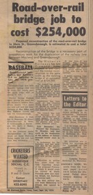 Greensborough Historical Society
Newspaper Clipping - Digital Image, Diamond Valley News, Main Street Road and Rail Bridge job to cost $254,000, 1974, 24/09/1974
... Main Street Road and Rail Bridge job to cost $254,000, 1974...Proposed reconstruction of the road-over-rail bridge... clipping, black text. Main Street Road and Rail Bridge job to cost ...Proposed reconstruction of the road-over-rail bridge in Main Street Greensborough was expected to cost $254,000 in 1974. Digital copy of newspaper clipping, black text.main street greensborough, greensborough station, rail bridge greensborough -
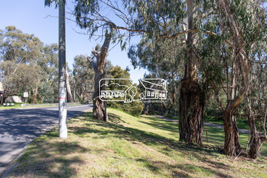
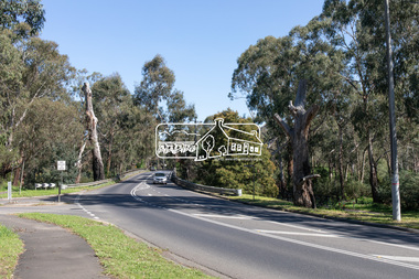
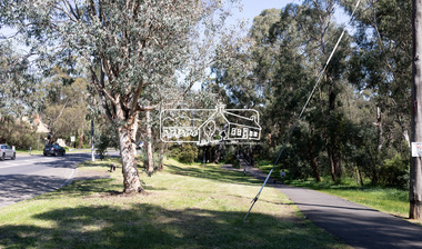
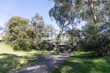
 Eltham District Historical Society Inc
Photograph, Jim Connor, Main Road, Eltham, 14 Jan 2017
... of Main Road and Bridge Street. It was close to this location... of Main Road and Bridge Street. It was close to this location ...Eltham Gateway, Alistair Knox Park from near intersection of Main Road and Bridge Street. It was close to this location that the Eltham Obelsik was originally located in 1919 and had to be relocated when roadworks were undertaken to widen the intersection.Tomorrow's history documented todayeltham, jim connor collection, main road, eltham gateway, alistair knox park -
 Hume City Civic Collection
Report Book
... Hand written reports on condition of roads and bridges... melbourne Hand written reports on condition of roads and bridges ...Hand written reports on condition of roads and bridges, cost and materials used for repairs, successful contractors named and also reports on tree planting all within the Shire of Bulla. The reports have been written by the Shire Engineer.Green and red covered hard cover book. Spine and corners red with small embossed design. Brown and blue mottled pattern inside front and back covers. Hand written using ink."Shire Hall/Bulla 14th March 1883..."1880s, 1900s, shire of bulla, road construction and maintenance, bridges, bulla, sunbury, george evans collection -
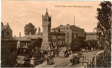 Federation University Historical Collection
Postcard - photographic, Clock Tower and Infirmary, Salisbury
... Sepia photographic postcard depicting a bridge and road... carriage bridge Sepia photographic postcard depicting a bridge ...The Salisbury Clock Tower was built in memory of Arabella Roberts who died on 23 January 1892. The firm Smith of Derby installed the illuminated clock mechanism with four faces and was still responsible for maintenance when, in December 1970, it replaced the original gravity mechanism with a more modern movement. The original clock mechanism was sold to a customer in Providence, USA. In 1997, the new mechanism was completely refurbished and updated to include automatic adjustment for British Summer Time. At the same time the tower itself was restored, the main contractors for this work being R. Moulding and Co of South Newton. Smith of Derby continues to be responsible for maintaining the clock, and so this firm has now been providing a service to the City for over 100 years. Sepia photographic postcard depicting a bridge and road lined with buildings and a clock tower in Salisbury, Wiltshire, England.salisbury, clock tower, chatham-holmes family collection, carriage, bridge -
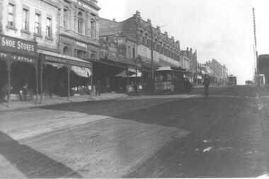 Melbourne Tram Museum
Photograph, Cable tram 41 Bridge Road Richmond, c1900
... Cable tram 41 Bridge Road Richmond....Bridge Road... of Bridge Road remain today including the former Forbes and Sons... The photograph shows cable, trailer 41 climbing the Bridge Road hill just ...The photograph shows cable, trailer 41 climbing the Bridge Road hill just west of Waltham Steet bound for the city. A second cable set can be seen in the distance, bound for Hawthorn Bridge. Nearly all of the buildings on this south side of Bridge Road remain today including the former Forbes and Sons building. Photo possibly dated c1900.Yields information about cable trams in Bridge Road Richmond and associated buildings.Photograph, black and white, plain papertrams, tramways, cable tram, bridge road, tram 41, richmond -
 Eltham District Historical Society Inc
Photograph postcard, Nearing the Station; postcard from Emily for Christmas
... View looking north along Main Road from Bridge Street... melbourne View looking north along Main Road from Bridge Street ...View looking north along Main Road from Bridge Street to York Street. Shillinglaw Cottage and the Shillinglaw trees are visible in the centre distance. Possibly Sunday sightseers who have come out on the train from Melbourne. Digital file only Postcards scanned from the collection of Michael Aitken on loan to EDHS, 13 Feb 2018michael aitken collection, postcards, eltham, main road, shillinglaw cottage, shillinglaw trees, york street, bakery