Showing 40534 items matching "roads and streets"
-
 City of Kingston
Photograph - Black and white, 5 January 1984
Moorabbin, Cheltenham and Highett are suburbs in the City of Kingston with a diverse mix of development and zoning. The market gardens, farms and paddocks have gradually been sub-divided into housing and industrial estates and associated infrastructure such as schools and shopping facilities. The area includes many parks, reserves and golf courses.This aerial image covers a diverse section of the City of Kingston, taking in the suburbs of Cheltenham, Moorabbin, Beaumaris and Highett. By 1984, the market gardens of the district have been replaced by housing and factories. The Gas and Fuel state-of-the-art Scientific Services Department is visible on Nepean Highway Highett. The CSIRO Highett site can also be seen. Both sites have now been demolished and have undergone remediation. The Southland site is visible and yet to be redeveloped by Westfield. This image portrays the diversity of development in the City of Kingston with a mixture of green spaces, housing and commercial and industrial features.Aerial photograph of Cheltenham, Beaumaris, Moorabbin and Highett within the City of Kingston. The area depicted in the 1984 aerial view includes Eden Street and Edward Street, Cheltenham (top left), Weatherall Road and Reserve Road, Cheltenham/Beaumaris (top right), Turner Road and Chesterville Road, Moorabbin (bottom left), Nepean Highway (left section), Graham Road and Middleton Street, Highett (bottom right). A large section of this image includes Cheltenham Park and Victoria Golf Club.White text: 3831-219 Lens information [indecipherable] RINGWOOD M/S 7922-3 RUN 15 Clockface image 5,300' ASL VIC DLS© 5-1-84cheltenham, highett, industrialisation, urbanisation, moorabbin, beaumaris -
 Ringwood and District Historical Society
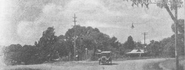
Photograph, Whitehorse Road and Mount Dandenong Road, including early electric installation of street lighting. (Undated)
Written on back of photograph, "Whitehorse Road and Mount Dandenong Road". Catalogue card reads, "Early electric installation of street lighting". -
 Ringwood and District Historical Society
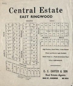
Flyer, Land Sale Advertisement, Central Estate, East Ringwood - 1948
East Ringwood Central Estate auction sale of allotments previously advertised for Saturday October 23rd (1948). Victorian Collections reference 5138 refers.Single sided leafletSubdivision includes Dublin Road, Knaith Road, Talofa Avenue, Russet Road, and Shasta Avenue. Agent - C.E. Carter & Son, Main Street, Ringwood. WU 6024. -
 Whitehorse Historical Society Inc.
Pamphlet, 'Boosting Box Hill'
Pamphlet describing vision for a revitalised Box Hill including plans for Carrington Road, Market Street Mall, Blank facades of Whitehorse Plaza, Prospect street, Whitehorse Road median, tramline extension to Mall Area.box hill carrington road -
 Whitehorse Historical Society Inc.
Photograph, Looking east to Mitcham, c1952
Sent to a parishioner at Christ Church, Mitcham, by Phyllis Grant who lived at the Migrant Hostel in Mitcham in 1952 -54, where her husband did development work under the P.M.G.Black and white photograph of Mitcham looking east from opposite Albert Street. Note the two lane road with trees each side of the road. Christ Church Mitcham in Edward Street can be seen on the left.whitehorse road, mitcham, christ church anglican church mitcham, grant, phyllis -
 Kew Historical Society Inc
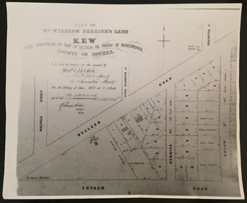
Print - Subdivision Plan, F Price, Plan of Mr William Derrick's Land, Kew being Subdivision of Part of Section 86, Parish of Boroondara, County of Bourke, 1872, 1872 [Original]
This work forms part of the collection assembled by the historian Dorothy Rogers, that was donated to the Kew Historical Society by her son John Rogers in 2015. The manuscripts, photographs, maps, and documents were sourced by her from both family and local collections or produced as references for her print publications. Many were directly used by Rogers in writing ‘Lovely Old Homes of Kew’ (1961) and 'A History of Kew' (1973), or the numerous articles on local history that she produced for suburban newspapers. Most of the photographs in the collection include detailed annotations in her hand.The Rogers Collection provides a comprehensive insight into the working habits of a historian in the 1960s and 1970s. Together it forms the largest privately-donated collection within the archives of the Kew Historical Society.A photographic reproduction of a plan in the Vale Collection of the State Library of Victoria showing William Derricks land in the area bordered by Bulleen Road (High Street); Cotham Road and Union Street. The plan dates from 1872.william derrick, subdivision plans -- kew (vic.) -
 Ringwood and District Historical Society
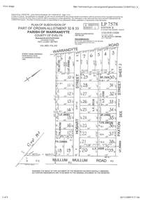
Document - Subdivision Plan, Part of Crown Allotment 32 & 33 Parish of Warrandyte, County of Evelyn Vol 3922 Fol 242
LANDATA Land Victoria 2-sheet plan printout dated 16/6/1919.Sheet 1 includes Warrandyte Road, Hobart Street, Paxton Street, and Mullum Mullum Road, Ringwood, Vic. Additional markings include PS327701, LP215189, RP7936, LP110103, LP36735, LP31149, SP24012, PS310739, PS326740, PS336885, LP41558. Sheet 2 includes Warrandyte Road, Paxton Street, Arnold Street, and Mullum Mullum Road, Ringwood, Vic. Additional markings include RO270, SP26622, LP50242, RP19467, SP27005, SP31440, PS312181. -
 Ringwood and District Historical Society
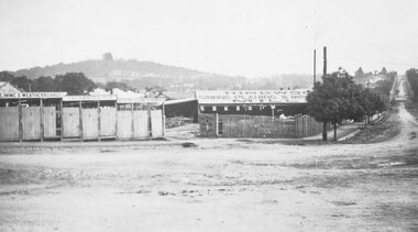
Photograph, Maroondah Highway Central, Ringwood. Bamford's Timber Yard, c1920
2 copies of photograph (1 black and white, 1 smaller sepia)Written on back of photograph: "Bamford, west corner of Warrandyte Road and Main Street". -
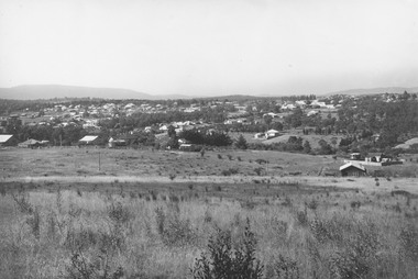
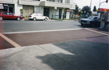
 City of Kingston
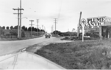
Photograph - Black and white, c. 1950
... Roads ...This image highlights the rural nature of the area during the 1950s where areas that are now major highways and intersections appear like country roads.Black and white photograph of the intersection of Warrigal Road and Centre Road in Oakleigh. There is a truck travelling south toward the camera along Warrigal Road which is a sealed road. On the right hand side is a Caltex petrol station with a street sign for Centre Road.Handwritten in blue ink on reverse: 2191 Handwritten in red ink on reverse: 72%oakleigh, cars, roads, suburbs -
 Marysville & District Historical Society
Photograph (Item) - Colour photograph, Unknown
A colour photograph of Murchison Street in Marysville in Victoria.A colour photograph of Murchison Street in Marysville in Victoria.murchison street, marysville, victoria, photograph -
 Marysville & District Historical Society
Photograph (Item) - Colour photograph, Unknown
A colour photograph of Murchison Street in Marysville in Victoria.A colour photograph of Murchison Street in Marysville in Victoria.murchison street, marysville, victoria, photograph -
Port Melbourne Historical & Preservation Society
Document - Specification, Tramway, Normanby Road, Ingles Street to Boundary Street, Port Melbourne, 14 Mar 1893
Written specification for works attached to plan of tramway in Normanby Road from Ingles Street to Boundary Street (Reg 66.1), 1893.A.V. Heath (Town Surveyor) J.J. Bartlett (Mayor)engineering - roads streets lanes and footpaths, transport - tramways, town planning, town clerks, mayors, arthur victor heath, james john bartlett -
Port Melbourne Historical & Preservation Society
Plan - Williamstown Road, Derham Street to Raglan Street, Port Melbourne, 14 Mar 1893
Plan of Williamstown road from Derham street to Raglan street. (67.1), together with written specification of works attached. (67.2), 1893.A.V. Heath (Town Surveyor). J.J. Bartlett (Mayor).engineering - roads streets lanes and footpaths, arthur victor heath, town clerks, james john bartlett, mayors -
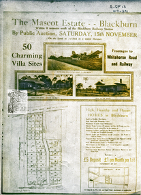 Whitehorse Historical Society Inc.
Document, Mascot Estate Blackburn
Subdivision of landSubdivision of land surrounded by Whitehorse Road, Simla street and King Street. 50 villa sites auctioned by M.Pullyn & Frank FisherSubdivision of land land subdivision, mascot estate blackburn, whitehorse road, blackburn, iona street, king street, simla street, pullyn, m, frank fisher & co. -
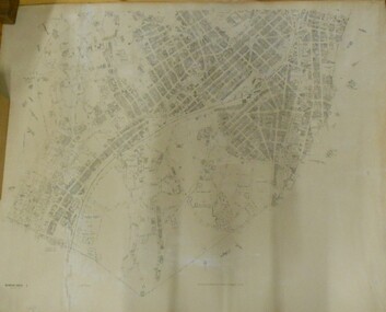 Bendigo Historical Society Inc.
Map - BENDIGO SHEET 2
Parish map showing the southern section of the City of Bendigo. It shows the city boundary running along Murphy Street, Grave (Patterson) Street, and the turns at the south end of Macdougall Road, the corner of Alder and Aspinal Streets and the corner near the Specimen Hill - Marong roads intersectionH.J. Green Govt. Printer, Melbournemap, bendigo, city streets, parish map, city boundary -
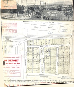 Ringwood and District Historical Society
Card - Land Subdivision Clipping, Heatherdale Station Estate, Ringwood, Vic. - circa 1923
Cardboard-backed partial front page copy of a land sale advertisement map with penciled sales notations for some blocks.Subdivision includes Heatherdale Road, Molan Street, Yallourn Parade, Newman Street, and Madden Street. Location map inset shows Purches Street and Forster Street, Mitcham, and approved site for Heatherdale railway station. -
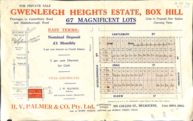 Whitehorse Historical Society Inc.
Document, Gwenleigh Heights Estate, Box Hill, unknown
Land plan of 67 allotments for sale between Canterbury Road, Middleborough Road and Agnew Street, Box Hill. (Now Blackburn South)land subdivision, middleborough road, blackburn south, canterbury road, agnew street, aberdeen road, h. v. palmer (estate agent) -
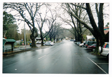
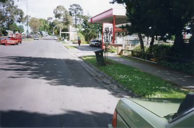 Whitehorse Historical Society Inc.
Photograph, Whitehorse Road, Mitcham - Service Road, 1/10/2000 12:00:00 AM
Coloured photograph of north Service Road in Whitehorse Road, Mitcham, looking west to shop and Service Station on the corner of Alexander Street Mitcham.service roads, whitehorse road mitcham, alexander street, mitcham -
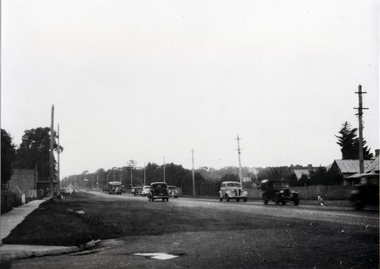
Eltham District Historical Society Inc
Photograph, George W. Bell, Main Road, Eltham 1950's, 1950s
photograph of Main Road, Eltham, between Dudley and Arthur Streets. c.1950smain road, eltham, shops, george w bell collection -
 Ringwood and District Historical Society
Photograph, Looking east from Loughnan Road across William & Andrew Streets c.1946
... Streets c.1946. ...Looking east from Loughnan Road across William & Andrew Streets 1946 -
Port Melbourne Historical & Preservation Society
Ceremonial object - Foundation stone, Missions to Seamen, Port Melbourne, 1937
During demolition of the 1937 Missions to Seamen building in October 1995, this stone was removed intact by developers Mirvac Victoria, and placed in the care of the PMH&PS.Cornerstone laid at the Missions to Seamen building, Beach Road and Swallow Street, in 1937.Engraved in black lettering on a granite background: To the glory of God and the welfare of all seafarers this foundation stone was laid by His Excellency the Governor of Victoria, the Lord Huntingfield K.C.M.G. May 18th 1937. This branch Institute of the Victorian Missions to Seamen was erected through the generosity of Alfred M Nicholas Esq. Office of Harry A Norris Architectsmissions to seamen, harry a norris, lord huntingfield -
 Whitehorse Historical Society Inc.
Photograph, Station Street, Mitcham, 1/10/2000 12:00:00 AM
Coloured photograph of South west corner of Station Street/ Whitehorse Road, Mitcham.station street, mitcham, whitehorse road -
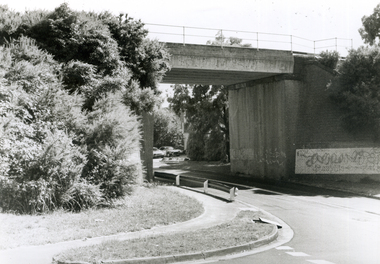 Whitehorse Historical Society Inc.
Photograph, Railway Bridge, 4/01/2001 12:00:00 AM
Black and white photograph of Railway Bridge, Cochrane Street and Brunswick Road, Mitcham.cochrane street, mitcham, brunswick road -
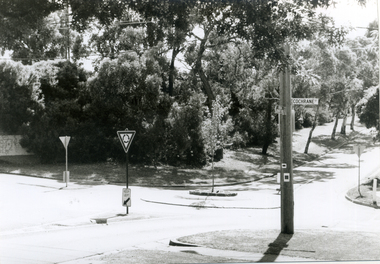 Whitehorse Historical Society Inc.
Photograph, Brunswick Road, Mitcham, 4/01/2001 12:00:00 AM
Black and white photograph of corner Brunswick Road and Cochrane Street, Mitcham.Looking West.brunswick road, mitcham, cochrane street -
 Whitehorse Historical Society Inc.
Photograph - Black and white photograph, Whitehorse Road at Chapel Street looking East, c1910
Used by donor in 'Blackburn - a picturesque history'Black & white photo showing Whitehorse Road at Chapel Street looking east.whitehorse road, blackburn, chapel street -
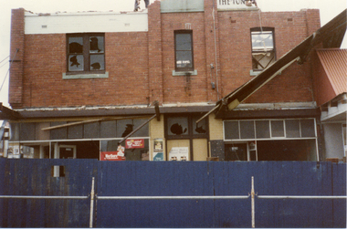 Whitehorse Historical Society Inc.
Photograph, Demolition Site, 1/11/1983 12:00:00 AM
Coloured photo of demolition site on corner of Station Street and Whitehorse Road Mitchamstation street mitcham, whitehorse road mitcham, demolition site -
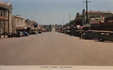 Ballarat Heritage Services
Photograph - Image from a Postcard Booklet Image, Vincent Street Daylesford, c1948
Daylesford in a tourist town with natural mineral water springsPhotographic image of a streetscape of Vincent Street Daylesford from Central Springs Roaddaylesford, central springs road, vincent street, streetscape -
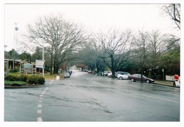
 Whitehorse Historical Society Inc.
Photograph, Whitehorse Road, Mitcham
Coloured photo of Whitehorse Road, Mitcham, west of Station Street. Taken 2003whitehorse road, mitcham -
University of Melbourne, Burnley Campus Archives
Photograph - Black and white print, 946/5, 30 March 1948
"30/3/48." Road to Plant Research laboratory from Swan Street.road, plant research laboratory, swan street, e. m. gibson collection -
University of Melbourne, Burnley Campus Archives
Photograph - Black and white print, 946/7, 30 March 1948
"30/3/48." Road to Plant Research Laboratory from Swan Street.road, plant research laboratory, swan street, e. m. gibson collection