Showing 11853 items
matching roads for victoria
-
 Marysville & District Historical Society
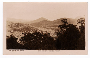
Postcard (item) - Black and white postcard, Rose Stereograph Company, Jock's Lookout, Marysville, Victoria, 1913-1967
... -Wood's Point Road near Marysville in Victoria. The Rose Series... in a series produced by the Rose Stereograph Company in Victoria ...A postcard in a series produced by the Rose Stereograph Company in Victoria, Australia as a souvenir of Marysville.An early sepia photograph of the view of the surrounding mountains taken from Jock's Lookout which is on the Marysville-Wood's Point Road near Marysville in Victoria.POST CARD The "Rose" Series/ De Luxe A Real Photograph/ Produced in Australia Published by the Rose Stereograph Co.,/ Armadale, Victoriajock's lookout, marysville, victoria, lookout, p. 2326, rose series postcard, postcard, souvenir -
 Lakes Entrance Historical Society
Photograph - Housing, 2000 c
... Williams Road, Lakes Entrance Victoria... Williams Road, Lakes Entrance Victoria Photograph Housing ...Second photo of front garden, stone fence with wrought iron inserts and stone pedestal with sundial.Colour photograph of timber dwelling. Tiled gabled roof, decorative stone work on chimney, stone front fence with wrought iron inserts. House renovated sometime during 1990's, aluminium framed windows installed replacing original timber sash windows, at 7 Williams Road, Lakes Entrance Victoriahouses, heritage study -
 Lakes Entrance Historical Society
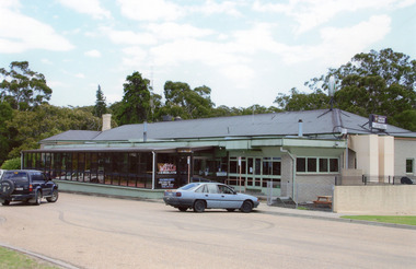
Photograph - Kalimna Hotel, Marion Holding, 2008
... outside the restaurant situated on Hotel Road, Kalimna... the restaurant situated on Hotel Road, Kalimna, overlooking Lakes ...Date made August 2008Colour photograph of Kalimna Hotel with vehicles parked outside the restaurant situated on Hotel Road, Kalimna, overlooking Lakes Entrance, Victoria.hotels, transport, room display -
 Lakes Entrance Historical Society
Postcard - Little River Falls , Wulgulmerang near Buchan Victoria, H D Bulmer, Buchan Victoria, 1920 c
... Black and white postcard showing a car parked on road above... on road above township of Buchan Victoria. Also an enlarged copy ...Black and white postcard showing a car parked on road above township of Buchan Victoria. Also an enlarged copy of same photographtownship -
 Ballarat Tramway Museum
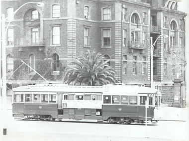
Photograph - Tram 36 passing Victoria Barracks, Dave Macartney, 9/1971
... Kilda Road, with the Victoria Barracks buildings... Kilda Road, with the Victoria Barracks buildings ...Photograph shows Ballarat SECV No. 36 northbound in St Kilda Road, with the Victoria Barracks buildings in the background. Photo taken Sept. 1971 when the tram operated promoting Ballarat tourism following the closure of the SECV Ballarat operated system. Photo by Dave Macartney.Yields information about the operation of Ballarat 36 in Melbourne promoting Ballarat tourism.Black and white photograph print with photographers notes on the rear."Ballarat 36 St Kilda Rd, Sept. 1971 - DMA 41, Dave Mcartney"tramcars, tram 36, st kilda road, tourism -
 Lakes Entrance Historical Society
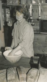
Photograph - Beachfield Farm Country Restaurant, Lakes Post Newspaper, 1990
... Restaurant Lake Tyers Beach Road Toorloo East Gippsland Victoria... Farm Country Restaurant Lake Tyers Beach Road Toorloo East ...Black and white photograph showing Caroline Joiner preparing dough for bread baked every day at Beachfield Farm Country Restaurant Lake Tyers Beach Road Toorloo East Gippsland Victoriabusinesses -
 Eltham District Historical Society Inc
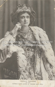
Postcard - Photo Postcard, Postcard: Camille Treherne as the Empress Marie Louise in "Madame Sans-Gêne", c.1913
... as a recluse in a shack in Ingrams Road, Research, Victoria, Australia... as a recluse in a shack in Ingrams Road, Research, Victoria, Australia ...An English actress in her younger days, Camille Treherne was active between 1909 and 1913. She played the role of Empress Marie Louise in "Madame Sans-Gêne" as shown in this postcard image. In her later years, Camille Treherne (Mrs Hill) lived as a recluse in a shack in Ingrams Road, Research, Victoria, Australia. Madame Sans-Gêne is a historical comedy-drama by Victorien Sardou and Émile Moreau, concerning incidents in the life of Catherine Hübscher, an outspoken 18th-century laundress who became the Duchess of Danzig. The play is described by its authors as "three acts with a prologue". "Madame Sans-Gêne (play)." Wikipedia https://en.wikipedia.org/wiki/Madame_Sans-Gêne_(play). Accessed 19 Oct. 2023.On reverse: Mrs Hill a recluse living in Ingrams Rd Research She was an actress (shown here) in younger days then lived in a "shack" in Research.actress, camille treherne, madame sans-gêne (play), postcard -
Ballarat Tramway Museum
Newspaper, The Courier Ballarat, "Tram Man's Miracle escape in collision", 1954
... notes a derailment of a tram at the junction of Main Road... a derailment of a tram at the junction of Main Road and Victoria St ...Newspaper clipping with details of the recovery using tram 21 following an accident between tram 37 and a semitrailer. Newspaper cutting gives details of those trammies involved, Dave Kellett and Herbert Ward. Collided with a semi carrying wool bales. Wal notes the tram was scrapped in 1955. Second cutting notes a derailment of a tram at the junction of Main Road and Victoria St. Noted the delays occurring. Wal has written the date of "Monday 15-6-1953" on the cutting. Contained within Reg Item 5507 - Foolscap binder with green covers, black binding edge and metal clips. See also Reg items 6313 and 5315 for similar items and 6320 for an article on David Kellett. Yields information about the accidents and derailments in Ballarat and collisions with vehicles that resulted in injuries to the driver and major damage to vehicles or passengers.Newspaper clipping from The Courier, 16/4/54 and hand written notes on the collision between with a semi trailer and tram No. 37. accidents, derailments, collision, tram 37 -
 Halls Gap & Grampians Historical Society
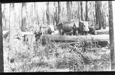
Photograph - B/W, C 1910
... of "Rosebank" on Neates Road in the Victoria Valley, however Guy Neate... 117-119 Grampians Road Halls Gap grampians The photo ...The photo is of an unknown bullock team in the Grampians. Note: The photo may have been taken by Guy E. Neate of "Rosebank" on Neates Road in the Victoria Valley, however Guy Neate did not buy that property until June 1926 (see the book "Water Between the Hills".The photo shows a team of bullocks surrounded by logs in a clearing in the bush. A man is just visible behind the bullocks.timber industries, logging, transport, bullock team -
 Melbourne Tram Museum
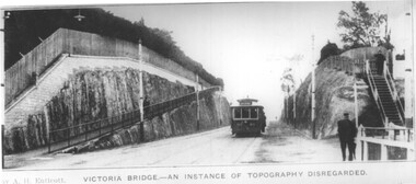
Photograph - Barkers Road cutting and tram 80, A H Enticott, c1915
... the Barkers Road cutting to Victoria Bridge. Has along the bottom... the Barkers Road cutting to Victoria Bridge. Has along the bottom edge ...Photo of PMTT tram No. 80, showing route 6, descending the Barkers Road cutting to Victoria Bridge. Has along the bottom edge the words "by A H Enticott, Victoria Bridge - an instance of topography disregarded." Possibly from a journal with the photo supplied by Mr Enticott, c1915.Yields information about PMTT tram 80.Black and white photograph with notes on the rear.In pencil "Prahran & Malvern"tramcars, tramways, tram 80, pmtt, barkers road -
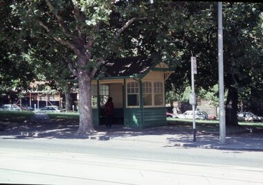
 Bendigo Historical Society Inc.
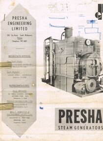
Document - BROCHURE: PRESHA STEAM GENERATORS
... , 290 City Road, South Melbourne, Victoria. Photo of large... Presha Engineering Limited brochure, 290 City Road, South ...Grey and white 2 page Presha Engineering Limited brochure, 290 City Road, South Melbourne, Victoria. Photo of large square shaped steam generator on front cover, written in pencil top centre ' Length 14.9'; width 6'10', height 11'3', 100 hp. Specifications written in centre pages and back page.organisation, commerce, presha steam generators -
 Tarnagulla History Archive
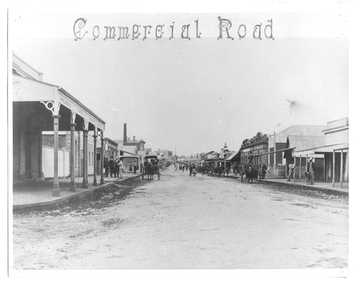
Photograph of Commercial Road, Tarnagulla, June 1866
... Monochrome photograph looking south down Commercial Road...Commercial Road, Tarnagulla, Victoria, Australia... in the colonies. tarnagulla views victoria hotel and theatre commercial ...Murray Comrie Collection. Copy of an 1866 photograph by Aimé Marchand. Victoria Hotel and Theatre is the stone building at centre right. On the immediate left is Pierce's Southern Cross Store, later to be incorporated into the flour mill complex. The gentleman in the white hat in the group on the left is George Thomson. In June 1866, Aimé Marchand (1846-1910) made a series of fourteen photographs which were submitted to the 1866-67 Melbourne Intercolonial Exhibition, where they earned a 1st Class Honorable Mention. This is one of those fourteen images. Of French or Belgian origin and possibly formerly an assayer in California, Marchand appears to have begun his practice of photography in Tarnagulla around 1865 as an assistant to A.B. Clay. By the following year he had settled in Portland, where he opened the Royal Photographic Studio in Gawler Street. From his base in Portland he toured surrounding districts, offering portrait and view services. Little else is known about his life. He appears to have left Australia in 1878. A misprint of his name in a local directory as Annie Marchand created the misconception that he was one of only a few named women photographers in the colonies. Monochrome photograph looking south down Commercial Road, Tarnagulla from near the Victoria Hotel and Theatre, at northern end of Commercial Road.tarnagulla, views, victoria hotel and theatre, commercial road, local people, residents, aimé marchand, photographers -
 Bendigo Historical Society Inc.
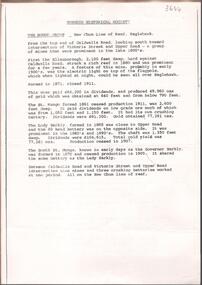
Document - NEW CHUM LINE OF REEF MUNGO GROUP EAGLEHAWK
... . Victoria Street and Upper Road marked on the map. 'Between... and Victoria Street and Upper Road intersection, nine mines and three ...Two page document detailing the Mungo Group of Mines along the New Chum line of reef, Eaglehawk. The mines described are: Ellenborough, 2100 feet deep St Mungo, 2,600 feet deep The Lady Barkly, 1,350 feet deep, close to Upper Road with a 40 head battery on the other side. South St Mungo, known as the Governor Barkly in the earlier days. Small map on second page shows the location of the Sadowa shaft, St. Mungo shaft and the Lady Barkly shaft. Victoria Street and Upper Road marked on the map. 'Between Caldwells Road and Victoria Street and Upper Road intersection, nine mines and three crushing batteries worked at one period. All on the New Chum line of reef.' Not signed but most probably written by Albert Richardson.bendigo, mining, mungo group of mines, eaglehawk -
 Royal Australian and New Zealand College of Obstetricians & Gynaecologists (RANZCOG)
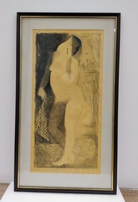
Drawing - Lithographic crayon on paper, John 'Jack' Courier, Standing Figure, c.1970s- early 1980s
... 'FRAMERY/78 Barkers Road/Hawthorn, Victoria, 3122/862 1957.'... of work is printed with text that reads 'FRAMERY/78 Barkers Road ...It is likely this item was received from the estate of John 'Jack' Courier. Courier left a bequest to the College consisting of a significant number of artworks by himself and others.Drawing in lithographic crayon on paper. Drawing depicts a nude female figure with abstract detailing. The drawing is in black crayon on yellow paper. Handwritten inscription at the bottom of the drawing reads 'Standing Figure J. Courier'. The drawing has been mounted on card and framed in a back frame with gold trim on the inner edge. Handwritten text on the back of the object reads '1970s-early 80s/Artist/JOHN COURIER/368 TOORAK RD/STH YARRA 3141/MELB VIC/MEDIUM DRAWING IN LITHOGRAPHIC CRAYON/Price $200'. There is a hanging wire as well as D ring fixtures attached to the back of the work for hanging. Small sticker at the bottom centre of back of work is printed with text that reads 'FRAMERY/78 Barkers Road/Hawthorn, Victoria, 3122/862 1957.' -
 Melbourne Tram Museum
Slide - Set of 15 - Railway MMTB Tram shelters, Robert Green, 2/1990
... - Cnr St Kilda Road and Bromby St 11 - Victoria and Brunswick... Kilda Road and Bromby St 11 - Victoria and Brunswick Streets 12 ...Set of 15 colour slides of Tramway Board and MMTB tramway shelters, by Robert Green Feb1990. 1 - Macarthur St and St Andrews Place (Tramway Board) 2 - Macarthur St and St Andrews Place (Tramway Board) 2A - Macarthur St and St Andrews Place (Tramway Board) - logon on the shelter 3 - SW Corner of St Kilda Road & High St 4 - Cnr St Kilda Road and Dorcas St 5 - Batman Ave and St Kilda Road - removed with Batman Ave closed, now at the TMSV Bylands 6 - ditto 7 - ditto - shows the Bundy clock on the office wall. 8 - Victoria and Brunswick Streets 9 - ditto 10 - Cnr St Kilda Road and Bromby St 11 - Victoria and Brunswick Streets 12 - Cnr Dandenong Road and Wattletree Road 13 - Victoria and Brunswick Streets 14 - Bourke and Spencer Streets - note the Bundy clock. Behind is the MTOCo Offices and Carlyons Hotel.Yields information about Melbourne tramway shelters.Set of 14 Kodak colour slides in plastic mounts and one unmounted phtographAll slides have their location marked on them in black ink.tramways, shelters, tramway board, mmtb, macarthur st, st kilda road, brunwick st, batman ave, victoria parade, wattletree road, bourke st -
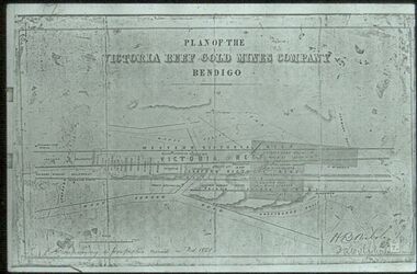 Bendigo Historical Society Inc.
Slide - ALBERT RICHARDSON COLLECTION: PLAN OF LEASES VICTORIA HILL
... . Mount Korong Road on bottom of plan, Victoria Reef running.... Mount Korong Road on bottom of plan, Victoria Reef running ...Slide. . Victoria Reef Gold Mines Company Mining Plan. Mount Korong Road on bottom of plan, Victoria Reef running through centre.mine, gold, victoria reef gold mines plan., bendigo mines-jack hattam collection -
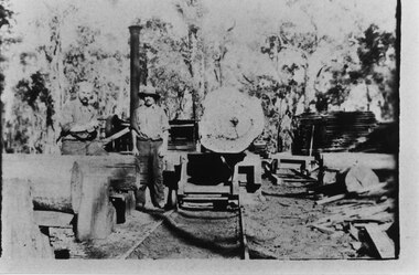 Halls Gap & Grampians Historical Society
Photograph - B/W, C 1910
... of "Rosebank" on Neates Road in the Victoria Valley, however Guy Neate... of "Rosebank" on Neates Road in the Victoria Valley, however Guy Neate ...The photo shows a timber mill in the Grampians. Neither the location nor the people are known. Note: The photo may have been taken by Guy E. Neate of "Rosebank" on Neates Road in the Victoria Valley, however Guy Neate did not buy that property until June 1926 (see the book "Water Between the Hills".The photo shows two men standing beside a trolley with a large log on it. There are other logs to the left and some sawn wood is visible stacked towards the back.timber industries, logging, sawmilling -
Mission to Seafarers Victoria
Letter - Correspondence, 1948
... Brunswick Road, West Brunswick, Victoria. Post-marked New York, NY... Brunswick Road, West Brunswick, Victoria. Post-marked New York, NY ...Quinn CollectionBlue, self-folding letter (0376), dated 22/06/48 and written on S.S.Lali, whilst in New YorkLetter is addressed to Mrs S Quinn, C/- Mrs Blackmore, 140 Brunswick Road, West Brunswick, Victoria. Post-marked New York, NY. Return address is S.S. Lali, C/- Thar Ekert & Co. 19 Rector Street, New York Cletters-from-abroad, quinn, 1948, new york, s.s.lali -
Glenelg Shire Council Cultural Collection
Card - Mobile Road Guide, c. 1970
... Light card. Mobile Road Guide of Victoria with insets... card. Mobile Road Guide of Victoria with insets of interstate ...Light card. Mobile Road Guide of Victoria with insets of interstate routes to Sydney and Adelaide. Pale green card, major highways in red, secondary roads dark green, major cities in black, mileage between markers, red. Road guide folded, black and white cityscape on front, bordered by dark green with white print, other symbols red, white, black.Back: Purple stamp 'REYNOLDS MOTORS PTY LTD 64 PERCY STREET PORTLAND TEL. 167.168 -
Lakes Entrance Historical Society
Photograph - Fielder Family Home Paynesville, 1915 c
... on the corner of Main Road and The Esplanade Paynesville Victoria... which once stood on the corner of Main Road and The Esplanade ...This building was once a shop. During WW1 the shop windows were boarded over, used as residence by the Fielder familyBlack and white photograph showing two women and four children on the veranda of a building which once stood on the corner of Main Road and The Esplanade Paynesville Victorialocal history, genealogy, buildings -
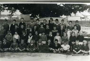 Whitehorse Historical Society Inc.
Photograph, Prep - Mitcham Primary - 1940, 1940
... in background at corner of Mitcham Road and Victoria Street. Back row... and stable in background at corner of Mitcham Road and Victoria ...Black and white photograph of Prep grade (Grade 1A) of Mitcham Primary School in 1940. Davin's Dairy and stable in background at corner of Mitcham Road and Victoria Street. Back row - ????Sargeant, David McLean, ???????, John Robertson, Keith Jones, Herb Lilburn, Dave Jones, Jeff Ellis, Alfred Gadsen. 2nd Row - Dawn freeman, Clare Smith, Barbara Savage, Keitha Petty, Marjory Stonehorn, Judith Honeybun, ??????, Pat Flynn, Peggy Burns, Betty Dashwood, Norma Hennessy. 3rd Row - Thelma Burton, Irene Schafer, Robin Leeworthy, Maureen Webster, Barbara Spelling, Margaret Newing, Judith Gorsuch, Lorna Treverton, Valda Hancock, Marion Cumming, ??? Taylor. Front Row - Bill McCaulay, Graham Clements, John Colman, Vernon Osterlind, Arthur Charles, ???? Boyle, Keith Brown, Alan Smith, Micky Dee, Lawrence Petty.mitcham primary school, no. 2904, sargeant, lilburn, herb, jones, keith, robertson, john, mclean, david, dave, ellis, jeff, gadsen, alfred, freeman, dawn, hennesy, norma, dashwood, betty, burns, peggy, flynn, pat, honeybun, judith, stonehorn, marjory, petty, keitha, savage, barbara, burton, thelma, smith, clare, schafer, irene, taylor, cumming, marion, hancock, valda, treverton, lorna, gorsuch, newing, margaret, spelling, webster, maureen, leeworthy, robin, bill mccaulay, fry, lawrence, dee, micky, alan, brown, boyle, charles, arthur, osterlund, vern, colman, clements, graham -
 Kew Historical Society Inc
Plan, Melbourne & Metropolitan Board of Works : Borough of Kew : Detail Plan No.1302, 1910
... stretched, then and now, from Studley Park Road to Victoria Street..., from Studley Park Road to Victoria Street, Richmond ...The Melbourne and Metropolitan Board of Works (MMBW) plans were produced from the 1890s to the 1950s. They were crucial to the design and development of Melbourne's sewerage and drainage system. The plans, at a scale of 40 feet to 1 inch (1:480), provide a detailed historical record of Melbourne streetscapes and environmental features. Each plan covers one or two street blocks (roughly six streets), showing details of buildings, including garden layouts and ownership boundaries, and features such as laneways, drains, bridges, parks, municipal boundaries and other prominent landmarks as they existed at the time each plan was produced. (Source: State Library of Victoria)This plan forms part of a large group of MMBW plans and maps that was donated to the Society by the Mr Poulter, City Engineer of the City of Kew in 1989. Within this collection, thirty-five hand-coloured plans, backed with linen, are of statewide significance as they include annotations that provide details of construction materials used in buildings in the first decade of the 20th century as well as additional information about land ownership and usage. The copies in the Public Record Office Victoria and the State Library of Victoria are monochrome versions which do not denote building materials so that the maps in this collection are invaluable and unique tools for researchers and heritage consultants. A number of the plans are not held in the collection of the State Library of Victoria so they have the additional attribute of rarity.Original survey plan, issued by the MMBW to a contractor with responsibility for constructing sewers in the area identified on the plan within the Borough of Kew. The plan was at some stage hand-coloured, possibly by the contractor, but more likely by officers working in the Engineering Department of the Borough and later Town, then City of Kew. The hand-coloured sections of buildings on the plan were used to denote masonry or brick constructions (pink), weatherboard constructions (yellow), and public buildings (grey). The absence of buildings and or property in Kew facing the Yarra is the most notable feature of this plan. Walmer Street and its bridge stretched, then and now, from Studley Park Road to Victoria Street, Richmond. On the Richmond side of the Yarra, there was evidence in 1904 of industry (‘Wool shed’; Soap Works’) and entertainment (‘Skittle Alley’). In reality, another Plan (No.1303) shows Chinese Gardens bordering the Yarra on the Kew side and buildings in Young Street.melbourne and metropolitan board of works, detail plans, mmbw 1302, cartography -
 Jewish Museum of Australia
Chess set
... and ink 4) 313a Dandenong Road Windsor 3181 Victoria Australia Tel... and ink 4) 313a Dandenong Road Windsor 3181 Victoria Australia Tel ...This chess set was carved from local wood with bases made from halved cotton reels. The chess pieces take the shape of Australian animals, and Aboriginal men and women. The set was presented to Mr. Benzion Patkin, Honorary Secretary of the Zionist Federation of Australia, by Tatura internees in recognition of his assistance, in particular, his assistance in facilitating the emigration to Palestine. According to Mr. Patkin, he received the chess set in a wooden box inscribed, "With our sincerest thanks from your Zionist friends - Tatura, on the way to Eretz Israel, per Leonhard Levin, 20.11.1942.".Written in pencil UR corner, upside down: (22) Printed in black ink: "B. & H. PATKIN Flat (printed 2 corrected in pen and ink 4) 313a Dandenong Road Windsor 3181 Victoria Australia Tel: Home 51 - 5671 Bus 63 - 8959"dunera, wwii, internees, jewish history & people -
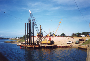 Lakes Entrance Historical Society
Photograph - North Arm Bridge, Davies Judy, 1999
... concrete road bridge. Lakes Entrance Victoria... of North Arm waterway, taken from walkway on old concrete road ...Date made 10 April 1999Colour photograph of the southern abutment of the now North Arm Bridge during construction. Three cranes in attendance distant view of North Arm waterway, taken from walkway on old concrete road bridge. Lakes Entrance Victoriabridges, construction -
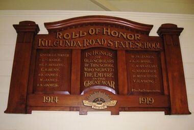 Coal Creek Community Park & Museum
Honour Roll, Kilcunda Road School Honor Roll
... and Buchanans' Roads, Bena, Victoria, 3946. The school was located... and Buchanans' Roads, Bena, Victoria, 3946. The school was located ...This WWI Honor Roll was originally displayed in the Kilcunda Road State School (no.3337), which was located at the north east corner of the intersection of the Bena - Kongwak and Buchanans' Roads, Bena, Victoria, 3946. The school was located amongst the cypress trees at 645 Bena-Kongwak Road. The school was relocated in 2008 to the Coal Creek Community Park and Museum, 12 Silkstone Road, Korumburra, 3950 to become the Masonic Lodge building in the park display. On the west side of the intersection of the Bena - Kongwak and Buchanans' Roads is a brass plaque on a granite boulder with the following inscription TO COMMEMORATE THE DISTRICT OF KILCUNDA ROAD First Surveyed 1879. This is the site of the KILCUNDA ROAD UNITING CHURCH 1911 to 1966. Diagonally opposite at 645 Bena-Kongwak Road was the site of the KILCUNDA ROAD PRIMARY SCHOOL No: 3337, 1902 to 1975. Erected by The School Mother’s Club continuing as The Kilcunda Road Social Club 2008. One of the few remaining historic items from Kilcunda Road settlement.Honour roll of varnished wood, with three panels, an undulating shaped pediment, plain columns at sides, painted gold text and the Australian Imperial Forces insignia on base.Roll of Honor, Kilcunda Road State School. In Honor of Old Scholars of this school who served the Empire in the Great War, 1914-1919, Australian Imperial Force. (X) These made the supreme sacrifice. Sister J.E. Turner , E.N. Barge, E.F. Binding (X), E.H. Bunn, D. James (X), W.James, A. James (X), R. H. James, A.G. Rose (X), C.W. Stanlake, G. Wuchatsch, R. Wuchatsch, T.E. Young kilcunda road, honour roll, state school no.3337., wwi -
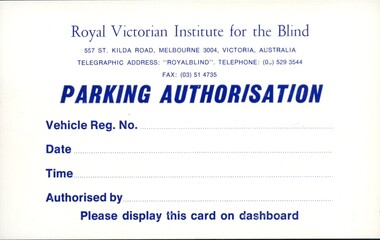 Vision Australia
Card - Document, RVIB Parking Authorisation cards, 196
... for the Blind 557 St Kilda Road, Melbourne, 3004, Victoria, Australia... for the Blind 557 St Kilda Road, Melbourne, 3004, Victoria, Australia ...This card provided the bearer with the ability to park on the RVIB grounds. It reads as follows: Royal Victorian Institute for the Blind 557 St Kilda Road, Melbourne, 3004, Victoria, Australia Telegraphic address: 'Royalblind". Telephone: (03) 529 3544 Fax: (03) 51 4735 Parking Authorisation Vehicle Reg. No. Date Time Authorised by Please display this card on dashboard1 white card with blue writing and spacing for handwritten detailsroyal victorian institute for the blind, office equipment and supplies -
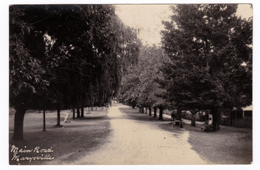 Marysville & District Historical Society
Postcard (item) - Black and white postcard, Main Road Marysville, Unknown
... A black and white postcard of the tree-lined main road... of the tree-lined main road in Marysville, Victoria. On the right-hand ...Postcard of early black and white photograph of the main street of Marysville in Victoria. This street is now known as Murchison Street.Postcard of early black and white photograph of the main street of Marysville in Victoria. This street is now known as Murchison Street.POST CARD PLACE/ POSTAGE/ STAMP/ HEREmarysville, victoria, murchison street, postcard, souvenir -
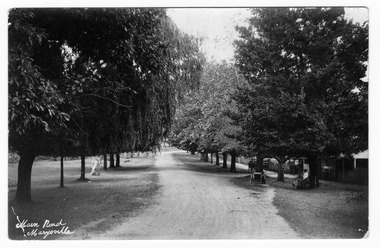 Marysville & District Historical Society
Postcard (Item) - Black and white postcard, Main Road Marysville, Unknown
... A black and white postcard of the tree-lined main road... postcard of the tree-lined main road in Marysville, Victoria ...Postcard of early black and white photograph of the main street of Marysville in Victoria.Postcard of early black and white photograph of the main street of Marysville in Victoria. This street is now known as Murchison Street.POST CARD PLACE/ POSTAGE/ STAMP/ HEREmarysville, victoria, murchison street, postcard, souvenir -
 Lakes Entrance Historical Society
Postcard - North Arm bridge Lakes Entrance Victoria, Bulmer H D, 1950c
... of road cutting. Lakes Entrance Victoria... poles on lower side of road cutting. Lakes Entrance Victoria ...3 Identical small format postcards 9 x 14Black and white small format postcard showing the town, North Arm bridge, Cunninghame Arm, sand hummocks, boat harbour, tourist launch approaching North Arm, power poles on lower side of road cutting. Lakes Entrance VictoriaLakes Entrance from Jemmys Pointbridges, township -
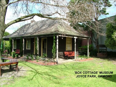 City of Moorabbin Historical Society (Operating the Box Cottage Museum)
Photograph - ' Box Cottage' Reconstruction, c1841
... the original pioneer cottage site, in Joyce Park, Jasper Road, Ormond... Park, Jasper Road, Ormond, Victoria. The museum has copies ...The original small, pioneer cottage was built in the late 1840s to early1850s, by an unknown pioneer. It was located on part of a 30 Acre allotment that was originally part of Henry Dendy’s Special Survey granted in 1841. The doors and window sashes, (made of red deal joinery timber), as well as the brass locks and fittings, are from the original cottage, and were imported from England.The fire-place bricks are from the original cottage, and are sun-dried, (not kiln fired), and are hand-made. Convict marks can be seen on two bricks.There is a small display of external cladding shingles from the original pioneer cottage. These shingles were hand-split, and most likely made from locally collected timber The nails included in this display were used to fasten the shingles on the original cottage, and are also hand-made. The enamel nameplate, “Colonial”, on the wall of the cottage, was the name chosen for the original pioneer cottage when a later owner, Mr August Rietman and wife Frieda leased the property in around 1917. August purchased the property 1935 for 1200 Pounds approximately and resided there until 1953. In 1974 Mr Lewis, a timber specialist, found the dilapidated building on property he had recently purchased in Jasper Rd and suggested it be reconstructed and relocated. Moorabbin Council agreed and the Cottage was rebuilt just about 250 metres from its original site. The cost of the rebuild was met by 'Victoria's 150th Committee, plus a small grant from the City of Moorabbin, and Mr Laurie Lewis donated much of the timber for the reconstruction. Although 'Box Cottage' is a re-construction, it is an unique museum that, being located in the midst of a modern community in Ormond Victoria, can educate and demonstrate many aspects of the early settler’s way of life in Victoria. As such, it is an invaluable resource for students and all kinds of visitors. The original small, pioneer cottage was built in the late 1840s to1850s, by an unknown pioneer. It was located on part of a 30 Acre allotment that was originally part of Dendy’s Special Survey granted in 1841. The re-constructed pioneer cottage, named ‘Box Cottage’, is located only a matter of metres from the original pioneer cottage site, in Joyce Park, Jasper Road, Ormond, Victoria. The museum has copies of interesting Land Titles associated with the surrounding land, including the site of the original pioneer cottage, from Dendy’s time, and into the 1900s. ‘Box Cottage’ is named after the pioneers, William and Elizabeth Box, who resided in the original cottage from approximately 1865, until Elizabeth’s death in 1914.The re-constructed cottage plan has followed faithfully the original dimensions, and plan of the original pioneer cottage, and as many original items from that cottage’s long occupation have been incorporated. Convict marks on sun -dried, fire-place chimney bricks. Enamel nameplate 'Colonial' circa1915brighton, moorabbin, cottages, pioneers, ormond, colonial, mckinnon, dendy henry, box william, box elizabeth, convicts, rietman august, rietman frieda, rietman stefanie