Showing 8443 items
matching snowy-river-dry-cleaners
-
 Falls Creek Historical Society
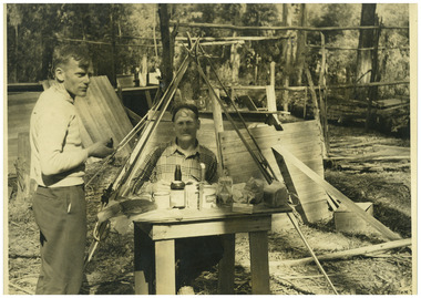
Photograph - Big River Survey Camp, c1949
MEYER COLLECTION - FALLS CREEK PHOTOS In 1947 a determined group of like-minded State Electricity Commission (SEC) staff including Ray Meyer, the chief surveyor of the Kiewa Hydro-Electric Scheme, had a common interest that revolved around the skiing potential of the snow-covered high plains which included what is now the resort of Falls Creek. The six SEC employees, Toni St Elmo, Ray Meyer, Jack Minogue, Lloyd Dunn, Adrian Ruffenacht and Dave Gibson (together with their families) banded together to secretly build a 'hut' that was the first ski lodge at Falls Creek. Using a road built in 1930s to gain access to Falls Creek, their hut project was carried out in secret as efforts by other skiers were blocked by H.H.C. Williams – the engineer in charge of the Hydro Scheme. In 1946 Ray Meyer made a trip to the Lands Office in Melbourne. He came away with a 99-year lease on three acres that was ideally suited for a hut designed by Lloyd Dunn. Adrian Ruffenacht (Design Engineer for the KHS) had suggested where the group should build because of easy access to a spring for water. Much of the building material required was scavenged from derelict huts on the high plains. Due to the need for secrecy, the determined group worked on the hut in the evenings and weekends to avoid detection. During the building period the group had met at Echidna Rock (now known as Eagle Rock) where Skippy St Elmo announced, "This is my favourite ‘Skyline’.” And so the first lodge in the area at Falls Creek Ski Resort came into existence. With the development of the International Poma in the 1970s, the Skyline Lodge, which was sited between the ski-lift’s pole one and pole two, was demolished. However, the legacy of Ray Meyer, Toni St Elmo, Jack Minogue, Lloyd Dunn, Adrian Ruffenacht and Dave Gibson and Skyline lives on in the vibrant atmosphere of Falls Creek Resort. The MEYER COLLECTION documents developments on the Kiewa Hydro Scheme and their life at Falls Creek from the mid 1930s to 1960s.This image is significant because it documents development of the Kiewa Hydroelectric Scheme.Two black and white images at the Big River Old Survey Camp.Photo 1 - Breakfast at Big River Left to RIght Ray Meyer, Wal Johnson Photo 2 - Big River Survey Camp at foot of T Spur C 1949, Kiewa RIver Survey Team.kiewa hydroelectric scheme, ray meyer, wal johnson -
 Port Fairy Historical Society Museum and Archives
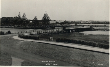
Postcard, Moyne River, Port Fairy
Circa 1902Black and white photograph of the Moyne river road bridge with no traffic taken for use as a PostcardMoyne River, Port Fairy - No23moyne bridge, circa 1900's, moyne river, bridge, road -
 Kew Historical Society Inc
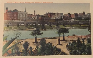
Postcard, River Yarra from Alexandra Avenue, Melbourne, c.1911
Collection of thirty-nine postcards donated by Jillian Rigby which had been owned by her grandparents, George and Edith Weir, who from c.1917 lived at 84 Princess Street, Kew. The mostly 'mint' postcards were purchased in Victoria and while travelling overseas. The sole dated postcard is dated from 1929. The postcards are numbered sequentially from 2017.0058.01-39. The remainder of the collection donated by Jill Rigby which was once owned by the Weirs of Broken Hill and Kew consist of costumes, costume accessories, photographs, and documents.The postcards in the Weir collection, especially those purchased on a trip or trips to the mother country, i.e. United Kingdom, represent a representative sample of sites that were considered significant to those Australians undertaking a reverse grand tour by member of the erstwhile colonies. Those postcards which are early views of Melbourne must have been produced commercially for some decades from the early part of the 20th century.River Yarra from Alexandra Avenue, Melbourne. Coloured postcard. Weir collection."River Yarra from Alexandra Avenue, Melbourne"postcards, george and edith weir, alexandra avenue - melbourne, yarra river, weir collection -
 Lakes Entrance Historical Society
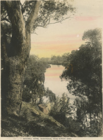
Postcard - Mitchell River Bairnsdale Victoria, Bulmer, 1920 c
One of the series of book cards sold to support the tourist industry in the saphire districtTinted postcard of scene of Mitchell River near rowing shed Bairnsdale VictoriaMitchell River Bairnsdale near rowing shed waterways, rivers -
 Orbost & District Historical Society
cloth badge, after 1950
The Snowy River Boat Club was formed in 1950, went into recess in 1972 but re-formed in 1977. It was a power boating club based in Marlo.A brim and band from a Snowy River Boat Club hat. There is a cloth badge of the Snowy River Boat Club. It is embroidered in blue and black with a boat outlined in red. The badge is square shaped and has rounded corners. It is loosely sewn above the black brim.snowy-river-boat-club power-boats -
 Lakes Entrance Historical Society
Photograph, fishing platform , Tambo River Victoria, 1/11/1994 12:00:00 AM
Black and white photograph showing crowd gathered at launch of the fishing platform installed by Tambo Nicholson Management Group and Department of Natural Resources and Environment on the bank of the Tambo River Victoria. Also three other black and white photographs showing the TAFE students under LEAP program building the fishing platform. birds, fishing, jetties -
 Lake Bolac & District Historical Society
Black and white photograph, "Lake Boloke" homestead and the dry shore-line of Lake Bolac, circa 1855
A very early view of the first blue-stone homestead and out-buildings at "Lake Boloke" station, established by Robert Patterson, believed taken in the early 1850's. The row of River red-gums indicates the shoreline of Lake Bolac which seems to be at least partially dry.lake bolac, lake boloke station, patterson -
 Orbost & District Historical Society
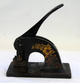
embossing machine
This was the seal for the snowy River Improvement Trust (1952-1997). The trust inaugurated the push with governments and government authorities to return the environmental flow of fresh water to the Snowy River at Jindabyne. During its existence the Trust worked hard to improve the health of the Snowy and Brodribb Rivers (revegetation, erosion prevention, fencing, drainage).This Common Seal will remind the lower Snowy district of the beneficial work of the Snowy River Improvement Trust during its existence from 1952 to June 30 1997.Common seal for the Snowy River Improvement Trust - 1952-1997. It is made of metal and has a lever to press down for the embossing stamp. The lever is spring loaded.snowy-river-improvement-trust snowy-river embossing-machine white-max -
 The Beechworth Burke Museum
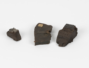
Geological specimen - Coorongite
Coorongite is a dark, rubber-like, highly resilient structureless algal deposit. In the Coorong district of South Australia it occurs in moderate quantities associated with the coastal swamps and sand dunes which extend for a considerable distance east of the mouth of the Murray. This particular specimen was recovered from the south of the Coorong River, South Australia. A type of sediment rich in organic matter, Coorongite is the unlithified end-member of the sapropelic coal series. The members of the sapropelic coal series can be ranked in order as sapropel (the unlithified form), sapropelic-lignite, and sapropelic-coal (the lithified forms) based on increasing carbon content and decreasing volatile content. Sapropel (Coorongite) is an unlithified dark, pulpy, fine organic mud containing concentrations of algae and miospores that are more or less identifiable. Coorongite is typically found as an algae like substance, that can be found in irregular size pieces. Coorongite was believed to be dried up oil due to its rubber-like texture. The Coorongite is also soft to the point where it can be cut into with a knife or it can be broken and torn by hand. Otherwise known as 'Kurangk', the Coorong River is home to the Ngarrindjeri people, which acts as both a place for gathering food and a spiritual place. In 1852 the first sight of Coorongite was found along the Coorong River. The finders mistook the Coorongite for dried up oil, which lead to the belief that there were oil reserves under the Coorong River. Between the 1860s and the 1930s the Coorong River became a place where mining oil and Coorongite became precedent. Nowadays, the local council and the South Australian Government are working together with the Ngarrindjeri people to sustain and preserve the Coorong River and the culture that is with it. Soon after gold was discovered in 1851, Victoria’s Governor La Trobe wrote to the Colonial Office in London, urging ‘the propriety of selecting and appointing as Mineral Surveyor for this Colony a gentleman possessed of the requisite qualifications and acquaintance with geological science and phenomena’. Alfred Selwyn was appointed geological surveyor in Australia in 1852 which began the Geological Survey of Victoria. Selwyn went on to collect geological samples and catalogue thousands of specimens around Australia. In 1853-69 the Geological Survey issued under Selwyn's direction sixty-one geological maps and numerous reports; they were of such high standard that a writer in the Quarterly Journal of the Geological Society of London bracketed the survey with that of the United States of America as the best in the world. During his years spent in Australia, Selwyn collected numerous significant geological specimens, examples of which are held in collections such as the Burke Museum.Coorongite is considered to be a mineral with a unique texture, where it can be both hard and soft. Coorongite can also be considered to be a rare mineral, as it is only located along the Coorong River and due to the mining of it, has left very few sources. It was believed at one point that Coorongite could be used to replace oil. This specimen is part of a larger collection of geological and mineral specimens collected from around Australia (and some parts of the world) and donated to the Burke Museum between 1868-1880. A large percentage of these specimens were collected in Victoria as part of the Geological Survey of Victoria that begun in 1852 (in response to the Gold Rush) to study and map the geology of Victoria. Collecting geological specimens was an important part of mapping and understanding the scientific makeup of the earth. Many of these specimens were sent to research and collecting organisations across Australia, including the Burke Museum, to educate and encourage further study.Three solid varyingly hand-sized pieces of wooden appearing organic matter derived from the river in the Coorong District in South Australia. A rubber-like, highly resilient structureless algal deposit.Specimen 245 page 69 / in Descriptive Register / "Elcestic Bitumen, / Coorangite" South of / Coorung River, South Australia . / C. WIllman / 15/4/21burke museum, beechwoth, indigo shire, beechworth museum, geological, geological specimen, mineraology, coorong, coorong river, kurangk, ngarrindjeri, south australia, coorongite, coorongite specimen -
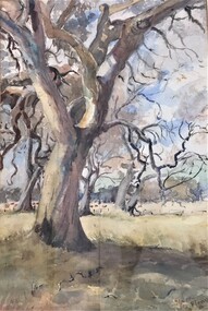
![Bend of the River Watt / [by] Nicholas Caire, circa 1876](/media/collectors/550653872162f11fb04854aa/items/577b52c2d0cdd10948cc9307/item-media/577b5328d0cdd10948ccc8b6/item-fit-380x285.jpg) Kew Historical Society Inc
Kew Historical Society IncPhotograph, Anglo-Australasian Photographic Company, Bend of the River Watt, c.1876
Nicholas Caire was born on Guernsey in the Channel Islands in 1837. He arrived in Adelaide with his parents in about 1860. In 1867, following photographic journeys in Gippsland, he opened a studio in Adelaide. From 1870 to 1876 he lived and worked in Talbot in Central Victoria. In 1876 he purchased T. F. Chuck's studios in the Royal Arcade Melbourne. In 1885, following the introduction of dry plate photography, he began a series of landscape series, which were commercially successful. As a photographer, he travelled extensively through Victoria, photographing places few of his contemporaries had previously seen. He died in 1918. Reference: Jack Cato, 'Caire, Nicholas John (1837–1918)', Australian Dictionary of Biography.An original, rare photograph from the series 'Views of Victoria: General Series' by the photographer, Nicholas Caire (1837-1918). The series of 60 photographs that comprise the series was issued c. 1876 and reinforced a neo-Romantic view of the Australian landscape to which a growing nationalist movement would respond. Nicholas Caire was active as a photographer in Australia from 1858 until his death in 1918. His vision of the Australian bush and pioneer life had a counterpart in the works of Henry Lawson and other nationalist poets, authors and painters.Views of Victoria (General Series) No.26 / 'Bend of the River Watt' / Albumen silver photograph mounted on boardOn Reverse: 'The present illustration represents a scene on the River Watt, and is situated in the valley between Mount Juliet and Mount Monda. The immediate neighbourhood abounds with scenery of the wildest and most romantic character. The River here is as clear as crystal, owing, no doubt, to its bed being composed of rock and pebbles. The banks on either side are studded with foliage so dense as to render access to the neighbourhood almost impracticable.’nicholas caire (1837-1918), australia - landscape photography -
 Port Fairy Historical Society Museum and Archives
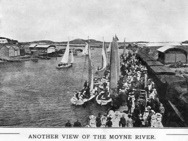
Photograph - Souvenir folder, Another View of the Moyne River
This photograph probably taken during Terang day. The people of Terang used to come to Port Fairy by train for the day and lots of events were put on for the people to take part in. Boating, swimming, picnicing in the botanical gardens, foot races, cricket etc.black and white photograph of the Moyne river showing a crowd of tourists possibly on Terang day as they alighted from the train that has pulled onto the wharfAnother view of the Moyne riversouvenir, port-fairy, terang day, train, wharf, moyne river, boats, crowd, people -
 Lakes Entrance Historical Society
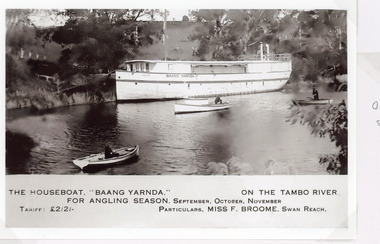
Postcard - Baang Yarnda, 1930c
The houseboat Baang Yarnda on the Tambo River for angling season, September October November. Tariff 2 pound 2 shillings Particulars Miss F Broome Swan ReachSepia toned postcard of the houseboat Baang Yarnda associated with Broome's Federal Hotel houseboat is moored in the Tambo River, people fishing from two small rowing boats and motor boat on river. Tambo Upper VictoriaThe Boat Baang Yarnda On the Tambo River. For Angling Season September, October, November Tariff Pounds 2/2/. Particulars:.Miss F Broome Swan Reachguesthouses, tourism, boats and boating -
 Whitehorse Historical Society Inc.
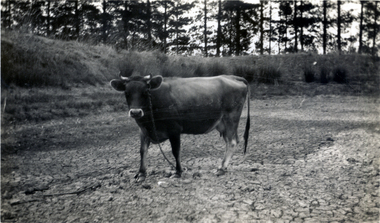
Photograph, Jones Flower Farm - Cow in dry dam, 1932
Jones Family Collection - NP2565 to NP2606. See also ND3831.Black and white photograph of cow in dry out dam on Jones' Flower Farm in Mt Pleasant Road, Nunawading, in 1932.jones, bette, walter, rolf, geoffrey, arthur, keith, lionel, muriel, jones flower farm, mount pleasant road nunawading -
 Wodonga & District Historical Society Inc
Album - Ringer's River by Des Martin - Plate 27 - Erin swims the river with a warning
Erin swims the river when she finds herself too late to reach the drovers before their crossing; and amazes O'Day and Keiran when she arrives with the news that the police have them cut off. Behind her a major storm up river is causing the water to rise.The album and images are significant because they document literature written by a prominent member of the Wodonga community. The presentation of this precis was supported by several significant district families and individuals.Ringer's River Album Coloured photo Plate 27des martin, many a mile, ringer's river, northeast victoria stories -
 Pyrenees Shire Council
painting, Dry Swamp by Maude Glover Fleay, 1935
"Maud Glover-Fleay b. 1869 A painter who studied under Frederick McCubbin, Glover was regarded for her natural history subject matter. She was also a writer and music teacher, and in the 1930s she established a reputation for painting Australian marsupials. Work is included in the Ballarat Fine Art Gallery, Ballarat, Victoria painting Signed: Glover-Fleay 35 (lower right) Verso: DRY SWAMP -
 Lakes Entrance Historical Society
Photograph - Bridges
Black and white photograph showing partially built McKillops Bridge on Snowy River, East Gippsland, Victoria.Cantilever new bridge over Snowy River at McKillops Crossing, 45 feet above recorded flood, washed away before officially opened, decking, etc, down stream more than a mile. (on back)bridges, waterways, topography, construction -
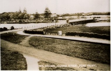 Port Fairy Historical Society Museum and Archives
Postcard, Valentine Publishing Co, The Bridge Moyne River Pt Fairy, 10.04.1929
Black and white Photograph of the bridge crossing the Moyne river with Gipps street in the foreground cleared land in the background taken for use as a postcardThe Bridge Moyne River Pt Fairymoyne bridge circa 1930, bridge, moyne river, river, road -
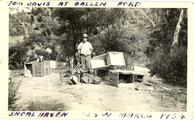 Federation University Historical Collection
Photograph - Photograph - black and white, Oallen Ford and Shoalhaven River, 1934, 1934
Two black and white photographs associated with Donald Mather. .1) A man, Tom Davis stands surrounded with gold mining equipment such as gold pans, cradles, picks and buckets. He is at Oallen Ford on the Shoalhaven River, New South Wales .2) A man stands beside a ute with 2 women standing on the tray. The photo was taken after crossing a ford at Shoalhaven, New South Walesdonald mather, mather, shoalhaven river, mining, ute, utility, car, gold mining -
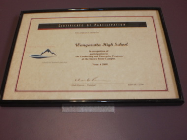 Wangaratta High School
WHS Framed Certificate, 2007, 2009
Two beige certificates of participation with a red border and black bar along the top framed in a simple black frame. A red and blue Snowy river Campus School for Student Leadership logo is on the left, and black text to the right reads:Snowy River Campus School for Student Ledership CERTIFICATE OF PARTICIAPTION This certificate is awarded to Wangaratta High School in recognition of participation in the Leadership and Enterprise Program at the Snowy river campus Term 2 2007 / Term 4 2009 Mark Reeves- Principal -
 Melbourne Tram Museum
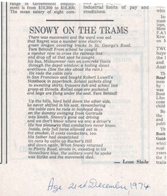
Newspaper, The Age, "Snowy on the Trams", 21/12/1974 12:00:00 AM
News paper clipping from The Age, 21/12/1974, titled "Snowy on the Trams", a poem by Leon Slade, about route 9 trams, St Georges Road, San Francisco cable cars and people.trams, tramways, poem, people and places, route 9, st georges road, san francisco -
 Orbost & District Historical Society
photograph, first half of 20th century prior to 1976
Purchased from Orbost Op shop several years ago. Original owner unknown. This bridge over the Snowy River was opened on July 4 1922. It was constructed in 1922 alongside the previous suspension bridge. Its building was a combined effort of the Victorian Railways and the Country Roads Board at a cost of 35,000 pounds. It was replaced in 1976 by the present bridge after several major floods.This bridge was replaced in 1976 after several major floods.A wooden framed photograph of the second Snowy River bridge at Orbost.photograph snowy-river-bridge -
 The 5th/6th Battalion Royal Victoria Regiment Historical Collection
Print - Book, Miracle on the River Kwai
River KwaiWhite cover - black & green writingMiracle on the River Kwai5/6 rvr, officer's / sergeant's mess -
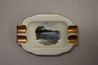 Warrnambool and District Historical Society Inc.
Ashtray, Alka Kunst, Warrnambool Hopkins River, c. 1960
This item was bought as a souvenir of Warrnambool in the mid 20th century when cigarette smoking was more widespread and was socially acceptable. Tourism in Warrnambool has been an important industry for over 100 years. In the late 19th century Warrnambool was promoted as a spa resort with its mild climate, sea bathing and its hot and cold sea water baths complex. Today visitors come in winter for the May Racing Carnival and to see the Southern Right whales at Logans Beach and in summer they come for a beach holiday. The image on the dish shows the Warrnambool Hopkins River near its mouth. The boatshed is no longer there with sections of the building being relocated to a site in Henna Street and used for indoor recreational purposes.This ash tray is retained as an example of a local tourist souvenir sold to tourists in the 1960s. This is a small white china dish made in an oval shape and slightly raised from the surface on which it sits. The ends of the dish have four gold coloured indents for stubbing cigarettes. There is a gold rim around the edge of the dish and a coloured image of the old boat shed and jetty on the Hopkins River in Warrnambool. On the base of the dish is the logo of the maker and printed details.Warrnambool Hopkins River Alka Kunst Bavaria tourism in warrnambool, history of warrnambool -
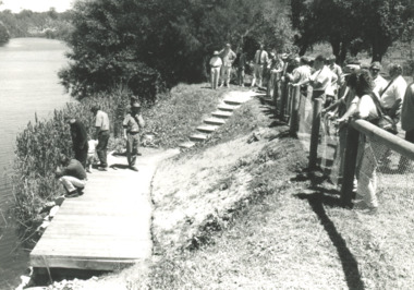
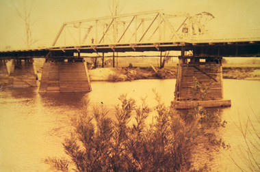
 Orbost & District Historical Society
black and white photographs, 25.11.1976
These photographs were taken on November 25, 1976 at the official opening of the current Snowy River road bridge. Included in the photographs are: John Duggan; Pat Hall, C.R.B. chairman, R.E.V. Donaldson (3240.7) and J.A.Rafferty, the state minister for Transport, who cut the ribbon (3240.8). Di Young and Cheryl Dusting (3240.9) distributed souvenir information pamphlets to official guests. The Snowy River road bridge is one of four built as part of the 8.4 km project spanning the Orbost flood plains. The Snowy River bridge and another over the nearby Ashbys Gulch are among the 10 longest bridges in Victoria, being the eighth and fifth longest respectively. The new bridge removed through traffic from Orbost township crossing the Snowy River 45 m downstream of the old bridge.This bridge is the fourth to provide a crossing to the township of Orbost. (info from CRB NEWS No. 34. DECEMBER, 1976) These photographs are pictorial records of a significant event in Orbost's history.Eleven black / white photographs all related to the official opening of the current Snowy River Bridge. Details are in catalogue folder.snowy-river-bridge -
 Ballarat Tramway Museum
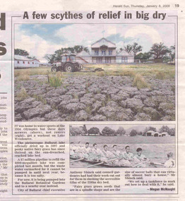
Newspaper, Herald Sun, "A few scythes of relief in big dry", 8/01/2009 12:00:00 AM
Newspaper clipping from the Herald Sun, Thursday 8/1/2009, titled "A few scythes of relief in big dry", with a photograph of the dry and cracked lake bed of Lake Wendouree and a photograph of it being used as a rowing course. Has some of the rowing sheds in the background and a track mowing the surface. Provides details of the pipeline that will be used to fill the lake when suitable.lake wendouree, drought -
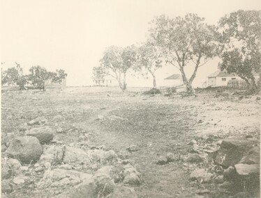
 Orbost & District Historical Society
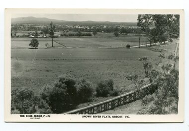
black and white photograph, Rose Stereograph Company, first half 20th century
The two bridges on the railway viaduct, which crosses the Snowy River floodplain at Orbost, were built from local Southern Mahogany. The bridge on the Bairnsdale end (770m) is now the longest in Victoria. Despite various attempts to extend the line, the station stayed on the western side of the Snowy River. (info. Helen Martin)This item is associated with the history of the Orbost-Bairnsdale railway line and therefore reflects the role that the rail line played in the social and economic history of Orbost.A black / white photograph / postcard of the Orbost township in the background and the railway viaduct over the flats in the foreground.photo caption - The Rose Series P.479 copywright SNOWY RIVER FLATS, ORBOST, VIC"east-gippsland-railway orbost-viaduct -
 Federation University Historical Collection
Photograph - Colour, Leigh River near Garibaldi Bridge
The Leigh River is a major tributary and catchment of the Barwon River. Fed by the Yarrowee River that rises near Ballarat, the Yarrowee reaches its confluence to form the Leigh in the vicinity of Cambrian Hill and Golden Plains Shire. The Leigh River rises below Mount Mercer and flows generally south, joined by three minor tributaries before reaching its confluence with the Barwon River, southeast of the central business district of Inverleigh. The river descends 265 metres (869 ft) over its 61-kilometre (38 mi) course. (https://en.wikipedia.org/wiki/Leigh_River_(Victoria)Relates to historical information about flooding of the Leigh River in 1933. Relevant to the history of Garibaldi and Durham Lead.A number of colour photographs showing the Leigh River between Garibaldi and Durham Lead, Victoria, .1 - .3) photographs of the Leigh River in flood .4 - .18) general photos of the Leigh River and surrounding countryside .19) broad angle photograph of the Leigh River and surrounding countryside leigh river, garibaldi, garibaldi bridge, durham lead, vincent family -
 Kew Historical Society Inc
Photograph, Marnie McLeod, Floods on the River Yarra at Kew, 1916
The donation was accompanied by the following letter from the donor: "Hi. I found these in with family photos. Taken by family as Mamie McLeod was living in Fellows Street, Kew, so would be near there. Retain (or discard) as you see fit." [Donor's name and address withheld from public view]. To gain an insight into the flood levels at Kew, it is worth reading newspaper accounts of the event. The Age published an article - Valuable Gardens Destroyed at Kew - on 25 September 1916: "VALUABLE GARDENS DESTROYED AT KEW. From the heights of Studley Park, Kew, a splendid view of the flood waters can be obtained, and yesterday afternoon, despite continuous rain, crowds of citizens assembled there to witness the spectacle. There is a vast stretch of water some 300 or 400 yards broad, above the foot bridge connecting Gipps-street, Collingwood, and Studley Park. The river is only about 3 feet from the top of the embankment connecting with the ramp of the bridge on the Studiey Park side. When the upper llood waters come down it is almost a certainty that tne embankment will be submerged and the bridge rendered impassible. Below the bridge the waters again stretch out, and have submerged all the low-lying land on the Collingwood side and invaded the back premises ot the Kodak Co., Phoenix Biscuit Factory, a tannery adjoining thereto, the Shamrock Brewery, and Chinese gardens in the vicinity. At Walmer-street-bridge, at the end of Studley Park, the low-lying land on the Kew side is covered with water to the depth of many feet. Tlie land in question is owned in a great part by Mr Frank Lavers who haa gone in for intense culture on a pretty liberal scale on both the slopes of the hill and on the river flat. On the latter he is cultivating many acres of asparagus, and has at a considerable cost spent three years in preparing the ground and installing an irrigation system, reticulated from the Yan Yean water supply. This year the asparagus was put down, and the plants were in a promising condition. Tlie flood waters are now flowing fast over the land. The crop is ruined, and three years' work and expenditure destroyed. Mr. Laver's private residence fortunately is high above flood level, but two houses he owns off Young-street have been flooded out. Having been warned in time, the tenants removed their furniture hefore the water came down to Mr. Laver's residence, where they themselves have been given accommodation in the meantime. All the river flats in East Kew are under water. One or two low-lying houses have been flooded. Chipperfield's boat shed at Willsmere is nearly covered, and some Chinese gardens in the vicinity are several feet under water."This, and the other three photographs donated of floods in Kew are believed to be the earliest in the collection. Together with our original MMBW River Yarra map showing flood levels, these items, when compared allow researchers to gain a visual perspective of the extent of the flood in 1916. Panoramic view, believed to be looking north towards Fairfield from the Zig-Zag Bridge on the River Yarra. The inscription on the reverese identifies it as taken before 1920.Inscription on reverse in ink "(pre 1920) Flood from Zig-zag bridge Yarra River, Kew Vic."river yarra, kew, floods 1916, zig-zag bridge -
Whitehorse Historical Society Inc.
Article, City puts 'dry' issue on hold, !997
Whitehorse Council has backed down from making a decision on Box Hill's controversial dry area until after the return of elected councillors in March.Whitehorse Council has backed down from making a decision on Box Hill's controversial dry area until after the return of elected councillors in March.Whitehorse Council has backed down from making a decision on Box Hill's controversial dry area until after the return of elected councillors in March.city of whitehorse, liquor licencing act, box hill -
Tatura Irrigation & Wartime Camps Museum
Photograph, Eildon Reservoir - Goulburn River, 1918
Taken by photographer for State Rivers and Water Supply Commission.Medium sized black and white photograph. Eildon Reservoir on the Goulburn River / Overall picture of dam (Right of wall) filled with water and some leisure craft moored near shore and huts / Dam wall and spillway / tree covered hills beyond"Eildon Reservoir - Goulburn River / Capacity - 306,000 acre feet / Rock filled dam with mass concrete spillway / Total length of dam - 3000 feet / Maximum depth of water - 123 feet - etc"victorian state rivers and supply commission, eildon dam