Showing 4224 items
matching the avenue
-
 Kew Historical Society Inc
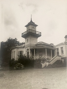
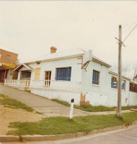
Photograph, J E & B L Rogers, 'Swinton', Swinton Avenue, c.1959
This work forms part of the collection assembled by the historian Dorothy Rogers, that was donated to the Kew Historical Society by her son John Rogers in 2015. The manuscripts, photographs, maps, and documents were sourced by her from both family and local collections or produced as references for her print publications. Many were directly used by Rogers in writing ‘Lovely Old Homes of Kew’ (1961) and 'A History of Kew' (1973), or the numerous articles on local history that she produced for suburban newspapers. Most of the photographs in the collection include detailed annotations in her hand.The Rogers Collection provides a comprehensive insight into the working habits of a historian in the 1960s and 1970s. Together it forms the largest privately-donated collection within the archives of the Kew Historical Society.Small black and white photograph of 'Swinton', Swinton Avenue, Kew"SWINTON"swinton -- swinton avenue -- kew (vic.), historic houses -- kew (vic.) -
 Port Fairy Historical Society Museum and Archives
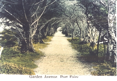
Postcard, Garden Avenue, Port Fairy
part of the historic botanical gardens in Port FairyHand tinted Photograph/postcard of garden avenue Port FairyGardens Port Fairygarden avenue, botanical -
 Canterbury History Group
Photograph - 12 Hopetoun Avenue, Canterbury, 1948
Home of Rosemary Golding, later Rosemary LavingtonBlack and white photograph of 12 Hopetoun Avenue, Canterbury 1948canterbury, hopetoun avenue, golding family, lavington> rosemary, street trees -
 Phillip Island and District Historical Society Inc.
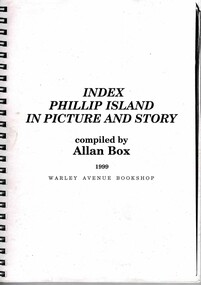
Booklet, Allan Box, Index Phillip Island in Picture and Story, 1999
Gliddon's book of this name is not indexed so this is a valuable for research purposes.HistoricalSmall spiral bound booklet with photocopied typed pages.Compiled by Allan Box 1999 Warley Avenue Bookshopj w gliddon, allan box, index, phillip island in picture and story -
 Ringwood and District Historical Society
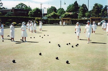
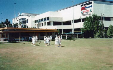
Photograph, Ringwood Bowls Club- The last Ladies Pennant game at Miles Avenue, 1997
Coloured photographPhotograph shows ladies playing a game at Miles Avenue. -
 Ringwood and District Historical Society
Photograph, Ringwood Bowls Club- The last Ladies Pennant game at Miles Avenue, 1997
Coloured photographPhotograph shows ladies playing a game at Miles Avenue. -
 Ringwood and District Historical Society
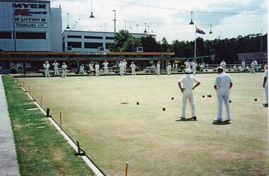
Photograph, Ringwood Bowls Club- The last Men's Friday Triples at Miles Avenue, 1997
Coloured photographPhotograph shows men playing a game at Miles Avenue. -
 Ringwood and District Historical Society
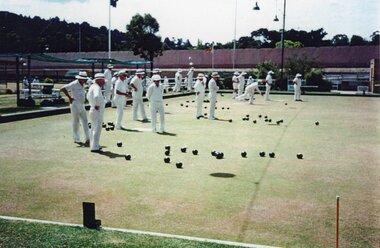
Photograph, Ringwood Bowls Club- The last Men's Friday Triples at Miles Avenue, 1997
Coloured photographPhotograph shows men playing a game at Miles Avenue. -
 National Wool Museum
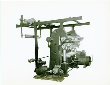
Photograph
Avenue Ironworks John Dalglish & Sons, Pollockshaws, Glasgow -
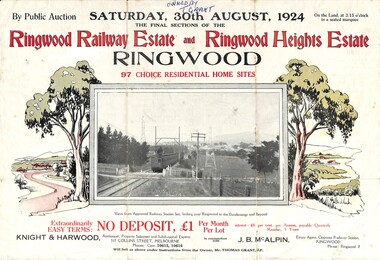 Ringwood and District Historical Society
Flyer, Auction Sale Advertisement - Ringwood Railway Estate and Ringwood Heights Estate, Ringwood, Victoria - August, 1924
Refer also to Reg. No. 5183 for Ringwood Railway Estate (September 1923) and Reg. No. 5184 for Ringwood Heights Estate previous release (March 1924)Folded double-sided brochure advertising public auction of Final Sections of Ringwood Railway Estate and Ringwood Heights Estate on Saturday, 30 August, 1924, with town photographs, location map, terms of sale, and summary of local features and services.Subdivision includes Whitehorse Road, Sherbrooke Avenue, Burwood Avenue, Bon View Avenue, Grant Crescent, Hillcrest Avenue, Heatherbrae Avenue, Margaret Street, and Mary Street. (Agents) Knight & Harwood, 315 Collins Street, Melbourne, Phones Central 10615, 10616, in conjunction with J.B. McAlpin, Opposite Railway Station, Ringwood, Phone Ringwood 7. Footnote - "Will sell as above under instructions from the Owner, Mr. Thomas Grant, J.P.". -
 Kew Historical Society Inc
Plan - Subdivision Plan, Old Kew Golf Links Estate - Third Section, 1920-1929
Pru Sanderson, in her groundbreaking ‘City of Kew Urban Conservation Study : Volume 2 - Development History’ (1988), summarised the periods of urban development and subdivisions of land in Kew. The periods that she identified included 1845-1880, 1880-1893, 1893-1921, 1921-1933, 1933-1943, and Post-War Development. These periods were selected as they represented periods of rapid growth or decline in urban development. An obvious starting point for Sanderson’s groupings involved population growth and the associated economic cycles. These cycles also highlighted urban expansion onto land that was predominantly rural, although in other cases it represented the decline and breakup of large estates. A number of the plans in the Kew Historical Society’s collection can also be found in other collections, such as those of the State Library of Victoria and the Boroondara Library Service. A number are however unique to the collection.The Kew Historical Society collection includes almost 100 subdivision plans pertaining to suburbs of the City of Melbourne. Most of these are of Kew, Kew East or Studley Park, although a smaller number are plans of Camberwell, Deepdene, Balwyn and Hawthorn. It is believed that the majority of the plans were gifted to the Society by persons connected with the real estate firm - J. R. Mathers and McMillan, 136 Cotham Road, Kew. The Plans in the collection are rarely in pristine form, being working plans on which the agent would write notes and record lots sold and the prices of these. The subdivision plans are historically significant examples of the growth of urban Melbourne from the beginning of the 20th Century up until the 1980s. A number of the plans are double-sided and often include a photograph on the reverse. A number of the latter are by noted photographers such as J.E. Barnes.When the old Kew Golf Links was subdivided in the mid 1920s, the developers were able to break the sale into sections. The third section included eighty lots. The lots faced Kilby Road, Kodak Avenue, Belford Road, Baker Avenue, Mathers Avenue, and White Avenue. [Kodak Avenue was renamed Page Avenue at a later date].The ‘Kew Conservation Study (1988) notes that ‘On the subdivision plan, Kodak’s involvement is commemorated by the naming of the streets after Company directors, and their decision to not proceed with the construction of the factory is explained as a response to the increase in the value of the land. This explanation may have been Estate Agent’s hyperbole, as the Kodak Company records suggest that the land, with its wide creek gully, was unsuitable and too small for its purposes.subdivision plans - kew, old kew golf links estate - third section -
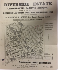 Kew Historical Society Inc
Plan - Subdivision Plan, Riverside Estate, Camberwell North (Balwyn), 1938, 1939
This subdivision known as the Riverside Estate wa sone of the largest and most significant in Balwyn's history.Subdivision Plan for 41 lots within the wider Riverside Estate in Camberwell North, now Balwyn, in February 1938. The auction featured lots in Burke Road, The Boulevard, Mt View Road, Wattle Avenue, Kyora Parade, Cascade Street, Riverside Avenue, Walbundry Avenue, Inverness Way, Bulleen Road and Doncaster Road.Allotments for sale are shaded grey on the map. Certain lots have an H in a circle. These are presumably where houses had already been constructed.subdivision plans - balwyn (vic), riverside estate - balwyn (vic) -
Federation University Historical Collection
Photograph, Poster for Ballarat First Ideal Homes Exhibition
Photograph of a poster for Ballarat's First Ideal Homes Exhibition at Colpin Avenueballarat ideal homes exhibition -
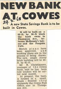 Phillip Island and District Historical Society Inc.
Newspaper Clipping, New State Savings Bank Cowes, 28/3/1968
Collection of newspaper clippings from Scrap Book 1960 - 1973Article about a new bank building to be built in Thompson Avenue, Cowes.state savings bank cowes, r christiansen bank manager, thompson avenue cowes, newspaper clipping, jean jamieson -
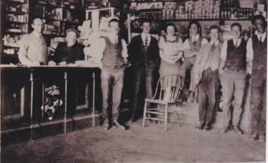 Phillip Island and District Historical Society Inc.
Photograph, Robb's store, Cowes, 1920
Inside of General Store. Probably Robb's as the photo was donated by Mary Robb. In background shelves stacked with groceries. Behind wooden counter, the Grocer standing and man in glasses, cap and seated along side Grocer. Standing in front of counter to one side, six waistcoated gentlemen and a lady. A wooden chair is located before the lady. An advertisement for Invicta Jelly Crystals is imprinted on the counter.Black and white photo of the inside of a general store, Thompson Avenue, Coweslocal history, photographs, buildings--historic, black & white photograph, mary robb -
 Phillip Island and District Historical Society Inc.
Photograph, 1978 - 79
Cowes Post Office built in 1909 with handmade bricks which were first used in the building of first Chicory Kiln in Cowes on Phillip Island in 1870 by the West brothers, Solomon and John. It is now a Restaurant and Pizza outlet.Large white building on the west corner of Thompson Avenue and The Esplanade, Coweslocal history, photographs, buildings, historic, buildings - historical, coloured photograph, john cook, phillip island, cowes old post office -
 Phillip Island and District Historical Society Inc.
Photograph, 1960
One of a collection of over 400 photographs in an album commenced in 1960 and presented to the Phillip Island & Westernport Historical Society by the Shire of Phillip IslandPhotograph taken in 1960 and looking south along Thompson Avenue, Cowes.local history, photography, thompson avenue, cowes, black & white photograph, thompson avenue cowes, john jenner, bryant west -
 Ringwood and District Historical Society
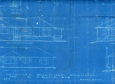
Plan, Architects plan for residence in Balfour Avenue, Heathmont for Stan Wieland , no date
Stanley Wieland took over the property called "Fairview" at the corner of Dickasons Road and Canterbury Road, Heathmont after his Father's death in 1945. He married Thelma Wilson in 1930. Their daughter Pat wrote the Wieland History with her husband Don Talbot.Architect's plan on heavy blue paper for residence at Balfour Avenue , Heathmont -
Port Melbourne Historical & Preservation Society
Plan - Walter Avenue, Port Melbourne, Town of Port Melbourne, 1893 - 1919
Plan of Walter Avenue showing various cross sections, date unknown.engineering - roads streets lanes and footpaths, walter avenue, loans program -
 Bendigo Historical Society Inc.
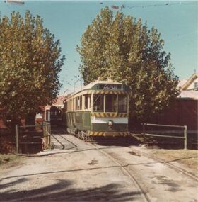
Photograph - GREATER BENDIGO PHOTO COLLECTION: TRAM
Photograph.Green tram No.5. Leaving the depot, which is at Tramways Avenue, Bendigo.tramways, history, bendigotramway -
 Whitehorse Historical Society Inc.
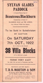
Document, Sylvan Glades Paddock Blackburn, C1922
Brochure advertising land salesBrochure advertising land sales on corner of Blackburn Road and The Avenue, Blackburn.Brochure advertising land sales land subdivision, sylvan glades paddock blackburn, t. r. b. morton & son, orchid street, blackburn, heath street -
Whitehorse Historical Society Inc.
Pamphlet, Norway Avenue, Blackburn, 1/09/1992
Advertisement for auction of 9 Norway Avenue, Blackburn, 12 September 1992.norway avenue, blackburn, auctions -
 Whitehorse Historical Society Inc.
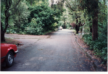
Photograph, Boongarry Avenue, Blackburn, 1/06/2003 12:00:00 AM
Coloured photograph of Boongarry Avenue, Blackburn. Narrow, treelined street with no footpaths.boongarry avenue, blackburn, fry, judith -
 Whitehorse Historical Society Inc.
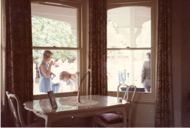
Photograph, Girrahween
Coloured photo of formal dining room of 5 Longland Avenue, Heatherdalelongland, captain, girrawheen, longland road, heatherdale, no. 5 -
 Rutherglen Historical Society
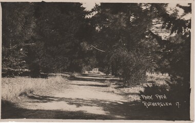
Image, Park Path Rutherglen 17, c1890
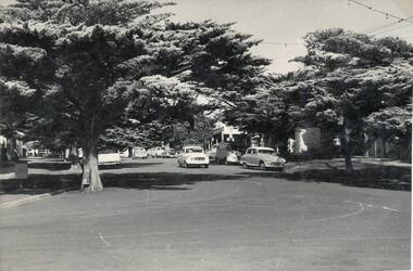
Path shown is on the western side of Lake King, Rutherglen. The pine trees have been replaced with river red gums.Black and white postcard photograph showing a path through and avenue of trees.Printed at bottom right of photo: "Park Path Rutherglen 17" Message written on back of card: "Dear Alban | Just a card to wish you the complements of the season. I've been so busy that I've not had time to write, so excuse this short note. Hoping you and yours are in the best of health as we are also. I am your affectionate cousin Olga"rutherglen park, lake king -
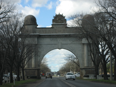 Ballarat Heritage Services
Photograph, Lisa Gervasoni, Ballarat Arch of Victory, 15/08/2007
Four views of the Ballarat Arch of Victoria, the entrance to the Ballarat Avenue of Honour.architecture, world war one, ballarat arch of victory, ballarat avenue of honour -
 Whitehorse Historical Society Inc.
Photograph, Electric Sub-station, Mitcham, 1998
Coloured photograph of sub-station in Vernal Avenue, Mitcham. House behind.electric sub-station, electricity -
Whitehorse Historical Society Inc.
Article, City council a victim of circumstances|Bureaucracy bogs down conference|Talks soon on council plan, 1972
Photocopy of three articles concerning Nunawading Council:Photocopy of three articles concerning Nunawading Council:|An unreported move by the Local Government Department has led to appeals against flats in McGhee Avenue not being delivered to the Department.|The Municipal Association of Victoria has said it cannot discuss Nunawading's motion for a tripartite conference between federal, state and local government.|Discussions will be held on a regional council including Box Hill, Camberwell, Knox, Waverley and Nunawading councils.Photocopy of three articles concerning Nunawading Council:city of nunawading, victoria. local government department, municipal association of victoria, city of box hill, city of camberwell, city of ringwood, city of knox, city of waverley, mcghee avenue, mitcham -
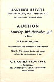 Ringwood and District Historical Society
Flyer, Land Sale Auction Brochure, Salter's Estate, East Ringwood, Vic. - 1956
Folded single page advertising auction of allotments on Saturday, 10th November (1956), including layout of subdivision and terms of sale.Subdivision includes Railway Avenue, Nicholson Street, Althol Grove (later Morcom Avenue), Illoura Avenue, Tweed Street, Merry Street, and Dublin Road. (Agent) C.E. Carter & Son R.E.S.I., Auctioneer, 126 Whitehorse Road, Ringwood, Phone WU6024. -
 Ringwood and District Historical Society
Flyer, Land Sale Advertisement and auction notice - Range View Estate, Ringwood, Victoria - 1920
Advertisement for sale of 150 residential allotments with terms of sale, summary of local features and services, and map showing location and layout of subdivision within the boundary of Mitcham to the west of Ringwood, Victoria. Copy of newspaper advertisement (The Herald, Melbourne, Wednesday 3 March, 1920) refers to public auction date for Range View Estate Ringwood - Saturday, 27th March, 1920.Subdivision includes Deep Creek Road, Range View Grove, Warnes Road, Tarrangower Avenue, Prince Edward Avenue, James Avenue, and White Horse Road, Mitcham. Agents - Phillips & Nicholson, 281 Collins Street, Melbourne, Telephone Central 10907.