Showing 297 items
matching timber industries
-
 Lakes Entrance Regional Historical Society (operating as Lakes Entrance History Centre & Museum)
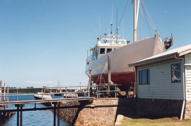
Photograph - Maramingo, Lakes Post Newspaper, 2000
Photo appeared in Lakes Post 12 January 2000Colour photograph of Gippsland Ports facility at Eastern Wharf. Timber fishing vessel Maramingo on slips, timber shed on land nearby, rock wall at edge of waterway, three fishing vessels in Cunninghame Arm. Lakes Entrance Victoriaships and shipping, fishing industry -
 Lakes Entrance Regional Historical Society (operating as Lakes Entrance History Centre & Museum)
Photograph - Maramingo, 2004
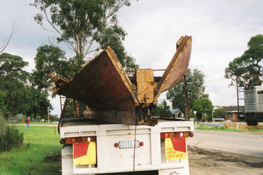
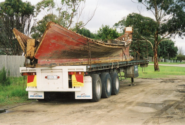
Vessel wrecked at the entrance 25 April 2006Colour photograph of the wrecked timber fishing boat, Maramingo on a semi-trailer in the industrial estate, Maramingo was wrecked on eastern spit at the entrance. Lakes Entrance Victoriaships and shipping, fishing industry, shipwrecks -
 Lakes Entrance Regional Historical Society (operating as Lakes Entrance History Centre & Museum)
Photograph - Maramingo, 2004
Vessel wrecked at the entrance 25 April 2005Colour photograph of the wrecked timber fishing boat, Maramingo on a semi-trailer in the industrial estate, Maramingo was wrecked on eastern spit at the entrance. Lakes Entrance Victoriaships and shipping, fishing industry, shipwrecks -
 Lakes Entrance Regional Historical Society (operating as Lakes Entrance History Centre & Museum)
Photograph - Fishing Industry, 1942 c
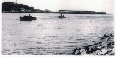
Also enlargement 17 x 24 cmBlack and white photograph of a small motor boat towing a rowing boat hauling a loaded fishing net inside the entrance. Timber entrance channel and flagstaff on hill in background. Lakes Entrance Victoriafishing industry, jetties, fish -
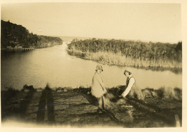 Lakes Entrance Regional Historical Society (operating as Lakes Entrance History Centre & Museum)
Postcard - tramline Lake Bunga, 1920
... Timber Industry...Bridges Timber Industry Waterways tramline Small format ...Small format black and white postcard showing a distant view of tramway bridge at Lakes Bunga, Victoria. Two women in foreground, image taken from Bunga Haven guesthouse.bridges, timber industry, waterways, tramline -
 Port of Echuca
Functional object - Outrigger Barge, Murray River Sawmills, D26, 1926
The D26 is an authentic outrigger logging barge - one of four that were towed by P.S. Adelaide for 80 years of its working life. In March 1987 Council purchased the barge from Deakin Shire in South Australia for $15,000. However, its restoration was put on hold until the crew had completed work on the P.S. Enterprise, eventually beginning in 1988 using local red gum. The barge was relaunched at Echuca East on Australia Day, 1990. The D26 remains at the Port of Echuca and on special occasions can be seen being towed by the P.S. Adelaide for demonstrations. The restored D26 outrigger barge is an example of early 20th century boat building technology developed for transporting reg gum logs downstream along the Murray River, often from the Barmah Forest to the Murray River Sawmills at Echuca. It shows the resourcefulness and manual transport techniques for a timber that does not float and had to be chained to the outrigging logs laying perpendicular to the hull. These outrigger barges could be let go to float with the current downstream with a bargeman onboard. Often there was no tiller or helm, but a chain was tied to the ballast at the back to keep the barge in the centre of the river channel. This allowed the Murray River Sawmills built 4 barges to go behind the PS Adelaide, the A11, the B22, the C24 and the D26. Timber outrigger logging bargeD26d26, p.s. adelaide, logging industry, murray river sawmill -
 Lakes Entrance Regional Historical Society (operating as Lakes Entrance History Centre & Museum)
Book, Pearson A M, Echoes from the Mountains and history of the Omeo Shire Council, 1969
... Timber Industry...Township Settlers Timber Industry Mines and Mining History ...History of the Shire of Omeo recounting the courage and determination of the early settlers who opened up and developed this remote region of Victorias high country exploiting the goldfields and establishing livestock and timer industries in the region.township, settlers, timber industry, mines and mining -
 Eltham District Historical Society Inc
Photograph - Digital Photograph, Marguerite Marshall, Strathewen Public Hall, 20 August 2008
Strathewen Public Hall, social and spiritual centre was later lost in the Black Saturday fires 2009. The Strathewen Community decided a community hall was needed in 1901. In 1902 locals built the hall with messmate trees. It was located on the Cottlesbridge-Strathewen Road. The first function was a Grand concert and Balll attended by about 120 people. Several denominations held Church services and Sunday School services in the Hall. It survived several bushfires until after this photo was taken when it was destroyed in Black Saturday, 9 February 2009. Published: Nillumbik Now and Then / Marguerite Marshall 2008; photographs Alan King with Marguerite Marshall.; p89 Strathewen was settled late, largely because it was difficult to access.1 Early selectors found it a struggle to survive. They had to do everything themselves, from felling trees for buildings, to taking produce to market along bush tracks that they had helped cut. Small dairy farms were typical but fruit became the district’s prime produce. The first settlers east of Arthurs Creek were brothers John and Duncan Smith whose station Glen-Ard was probably operated as a sheep run. Other early settlers were the Mann family, who were to donate land for the hall, provide postal services and John Mann was an Eltham Shire councillor from 1916 to 1919.2 In 1873 James Mann, his wife Jane and their six children, settled on 207 acres (83.7) (Lang Fauld Farm) on both sides of Eagles Nest Road, from the foot of Mount Sugarloaf to the bank of the Arthurs Creek. In 1883 James took up another selection on Chads Creek. It was very hard work and at times he was well behind with his rent. However the family had a good social life, attending the Primitive Methodist Church at the Arthurs Creek Township and on New Year’s Eve throwing a party for all the locals. By 1874 James Mann’s younger brother, John, selected 311 acres (125.8ha) between Eagles Nest Road and upper Arthurs Creek. He called it Carseburn after his home parish in Scotland. Tragically in 1875 John drowned in the Yarra River, at Richmond.3 John Mann’s oldest son, also John, later purchased Duncan Smith’s land, which he named Violet Glen. He was to give one acre (0.4ha) of this land for the Strathewen Hall site. A Mann family diary written at Carseburn in 1897, tells how the district’s name was selected. Strathewen is derived from ‘strath’ meaning ‘broad mountain valley’ and from the name of Ewen H. Cameron, the local parliamentarian for almost 40 years. ‘George Brain came around to get a petition signed to get a post office up here and we had to vote for a name—Strathewen, Glen-Ard, or Headcorie’.4 It was at Carseburn that a public meeting in 1901, decided to build the Strathewen Hall on the Cottlesbridge-Strathewen Road. In 1902 the locals built the hall with messmate trees. The first function was a Grand Concert and Ball attended by around 120 people and several Protestant denominations took turns to hold church services and Sunday School there. Fortunately the hall has survived bushfires to be the town’s spiritual and social centre.5 The area continued to develop and in 1909 a post office operated somewhere at Strathewen and from around 1916 at Carseburn.6 It was not until 1914 that land was bought to establish the Strathewen State School on School Ridge Road. The residents paid £100 to build it on two acres (0.8 ha) while the Education Department contributed £30 and leased the building annually for £1. When teacher Miss Mary Golding opened the school in 1917, it had no equipment.7 But in 1921 the Education Department provided desks and a hexagonal shelter shed (now a rare style in Victoria) and took control in 1925.8 By 1917 Strathewen was booming.9 George Apted had built a coolstore in 1916, and local orchardists bought storage space until the 1950s. This allowed the area to supply the market in and out of season. Guesthouses catered for growing tourism. In the mid 1920s Mrs Eleanor Sparkes built the guest-house Singing Waters, which operated through the 1930s. Her daughter Mrs Vera McKimmie, ran it until the 1950s and the house remains in Chads Creek Road. In the Great Depression land was cleared for timber to be sold as firewood and there was small scale sawmilling. However the orchard industry diminished for several reasons including the 1939 bushfires and rapid changes in production methods. Today the Apteds still operate an orchard and farm at Glen-Ard, which straddles the border between Strathewen and Arthurs Creek. It includes the southern part of Duncan Smith’s original Glen-Ard selection.This collection of almost 130 photos about places and people within the Shire of Nillumbik, an urban and rural municipality in Melbourne's north, contributes to an understanding of the history of the Shire. Published in 2008 immediately prior to the Black Saturday bushfires of February 7, 2009, it documents sites that were impacted, and in some cases destroyed by the fires. It includes photographs taken especially for the publication, creating a unique time capsule representing the Shire in the early 21st century. It remains the most recent comprehenesive publication devoted to the Shire's history connecting local residents to the past. nillumbik now and then (marshall-king) collection, strathewan public hall -
Lakes Entrance Regional Historical Society (operating as Lakes Entrance History Centre & Museum)
Book, Le Cheminant, Marion, Nyerimilang and its Neighbourhood, 1985
... Timber Industry...Settlers Agriculture Timber Industry Waterways Parks ...A history of Nyerimilang Homestead on the Gippsland Lakes at Kalimna West, from 1884 to 1985. Now the responsibility of National Parks.settlers, agriculture, timber industry, waterways, parks -
Lakes Entrance Regional Historical Society (operating as Lakes Entrance History Centre & Museum)
Book, Le Cheminant, Marion, Nyerimilang and its Neighbourhood, 1985
... Timber industry.... Settlers Agriculture Timber industry Waterways Parks Marion Le ...The original selection was cleared and farmed for Alexander Murray, becoming a holiday home for Hon. Frank Stuart in 1891.A hardcovered book relating a brief history of Nyerimilang homestead on the Gippsland Lakes at Kalimna West, from 1884 until 1985. Marion Le Cheminant October 1985settlers, agriculture, timber industry, waterways, parks -
Lakes Entrance Regional Historical Society (operating as Lakes Entrance History Centre & Museum)
Book, Rule Hilda, Back to Nowa Nowa, 1980
... Timber Industry...Township Settlers Timber Industry Schools Transport A short ...A short history of the timber township of Nowa Nowa, East Gippsland Victoria.township, settlers, timber industry, schools, transport -
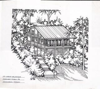 Whitehorse Historical Society Inc.
Artwork, other - Ink Line Drawing, Margaret Picken, 63 Lisbeth Ave., Mitcham, 1994
A property illustration by Margaret Picken Commissioned by a real estate agency for the purpose of advertising 63 Lisbeth Ave., Mitcham. This property has be listed as having sold for $325,000 in 2002. Made by using Rotring ‘Rapidigraph’ drafting pens with Rotring ink on Rapidigraph polyester drafting film, double matte. Trained as a cartographic draftsman within the mining industry, Margaret Picken is an artist who worked producing property illustrations for real estate agencies in eastern suburbs of Victoria from 1983-2005. Retiring from the industry as technological changes favored coloured photography over illustrations, and commissioning companies over sole contractors.This artwork is of Historical Significance as a record of local domestic architecture.A black ink line drawing on drafters film by Maragret Picken, of an angled view from above of a elevated bush block, with three story timber stilt house situated into the hill. In the lower right corner is the bottom of the hill, and a front lawn with a edged garden bed behind. While on either side of the house are steps leading up the hill to the back of the block. The house has steps leading up to a partial wrap around verandah There are two hole punch holes along the top edge63 Lisbeth Ave., Mitcham Margaret Picken - 94 Woodards -whitehorse historical society, schwerkolt cottage, housing, architecture, margaret picken, house, garden, real estate, mitcham -
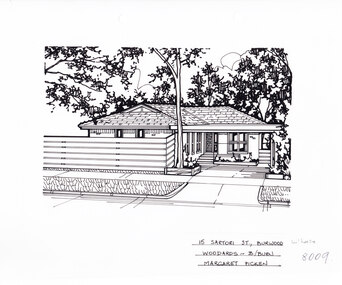 Whitehorse Historical Society Inc.
Artwork, other - Ink Line Drawing, 15 Satori St., Burwood, circa 1983-2005
A property illustration by Margaret Picken Commissioned by the real estate agency Woodards for the purpose of advertising 15 Satori St., Burwood Made by using Rotring ‘Rapidigraph’ drafting pens with Rotring ink on Rapidigraph polyester drafting film, double matte. Trained as a cartographic draftsman within the mining industry, Margaret Picken is an artist who worked producing property illustrations for real estate agencies in eastern suburbs of Victoria from 1983-2005. Retiring from the industry as technological changes favored coloured photography over illustrations, and commissioning companies over sole contractors.This artwork is of Historical Significance as a record of local domestic architecture.A black ink line drawing on drafters film by Margaret Picken, of 15 Satori St., Burwood. A single story brick house, with a driveway on the left leading to a connected carport which covers the front door. in the foreground is a horizontal plank timber fence, and a tall gumtree.15 Satori St., Burwood Woodards - B.Burn Margaret Pickenwhitehorse historical society, schwerkolt cottage, housing, architecture, margaret picken, burwood, house, garden -
Lakes Entrance Regional Historical Society (operating as Lakes Entrance History Centre & Museum)
Book, Trotter Georgina, Snuff Gully Sawmill and Camp Sites, 2000
... Timber Industry...Timber Industry Settlement Research and Interpretation ...Research and Interpretation of the Snuff Gully Sawmill and Camp Sites in the Colquhoun Forest, East Gippsland, and recommendations for the future management of site by Forestec student.timber industry, settlement -
Lakes Entrance Regional Historical Society (operating as Lakes Entrance History Centre & Museum)
Book, Anderson F B, Colquhoun Railway Siding and Railway Spur, 2000
... Timber Industry...Transport Timber Industry Research and interpretation ...Research and interpretation of the history of the Colquhoun, East Gippsland, railway siding and railway spur, and suggested management of the site by Forestec studend.transport, timber industry -
Lakes Entrance Regional Historical Society (operating as Lakes Entrance History Centre & Museum)
Book, Allard, Peter and Alues, Geoff, Border Tales - Stories from Genoa,Wangarabell, Wroxham.Timbillica, Maramingo, Nungatta, Wingan and Gipsy Point, 2000
... Timber Industry...Aboriginals Township Timber Industry Transport A short ...A short history of the life and times of residents of Genoa, Victoria, and associated border settlements. Not indexed, but has comprehensive contents list.aboriginals, township, timber industry, transport -
 Whitehorse Historical Society Inc.
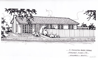
Artwork, other - Ink Line Drawing, Margaret Picken, 5 Manhattan Square., Vermont, 1995
A property illustration by Margaret Picken Commissioned by a real estate agency for the purpose of advertising 6 Lusk Dve., Vermont This property is listed as having sold for $136,000 in 1995 Made by using Rotring ‘Rapidigraph’ drafting pens with Rotring ink on Rapidigraph polyester drafting film, double matte. Trained as a cartographic draftsman within the mining industry, Margaret Picken is an artist who worked producing property illustrations for real estate agencies in eastern suburbs of Victoria from 1983-2005. Retiring from the industry as technological changes favored coloured photography over illustrations, and commissioning companies over sole contractors.This artwork is of Historical Significance as a record of local domestic architecture.A black ink line drawing on drafters film by Margaret Picken, of a single story brick house with a path up to the front door from the footpath in the foreground. On the left is a front lawn, and on the left is a timber fence enclosing the other half of the property frontage. There are two hole punch holes just below centre of the upper edge5 Manhattan Square., Vermont Margaret Picken - 95 Woodards - Balwynwhitehorse historical society, schwerkolt cottage, housing, architecture, margaret picken, house, garden, real estate, vermont, vermont south -
 Whitehorse Historical Society Inc.
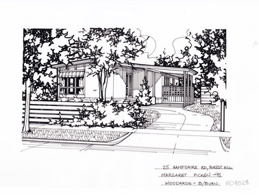
Artwork, other - Ink Line Drawing, Margaret Picken, 25 Hampshire Rd., Forest Hill, 1995
A property illustration by Margaret Picken Commissioned by the real estate agency Woodards Blackburn for the purpose of advertising 25 Hampshire Rd., Forest Hill. This property is listed as having sold for $104,000 in 1996. Since the time of sale in 1996 the house on the property has been demolished and a new house built on the site. Made by using Rotring ‘Rapidigraph’ drafting pens with Rotring ink on Rapidigraph polyester drafting film, double matte. Trained as a cartographic draftsman within the mining industry, Margaret Picken is an artist who worked producing property illustrations for real estate agencies in eastern suburbs of Victoria from 1983-2005. Retiring from the industry as technological changes favored coloured photography over illustrations, and commissioning companies over sole contractors.This artwork is of Historical Significance as a record of local domestic architecture.A black ink line drawing on drafters film by Margaret Picken, of 25 Hampshire Rd., Forest Hill. Depicting in the foreground a horizontal timber plank fence on the left, and a curving driveway on the right leading to a connected carport. In the background is a small house. There are two hole punch holes just right of centre on the upper edge. There is a 0.5x0.5 mark on the top half of the right edge25 Hampshire Rd., Forest Hill Margaret Picken - 95 Woodards B/Burnwhitehorse historical society, schwerkolt cottage, housing, architecture, margaret picken, house, garden, forest hill -
 Whitehorse Historical Society Inc.
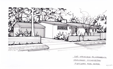
Artwork, other - Ink Line Drawing, Margaret Picken, 254 Springfield Rd., Nunawading, 2001
A property illustration by Margaret Picken Commissioned by a real estate agency for the purpose of advertising 254 Springfield Rd., Nunawading This property is listed as having sold for $220,000 in 2001 Made by using Rotring ‘Rapidigraph’ drafting pens with Rotring ink on Rapidigraph polyester drafting film, double matte. Trained as a cartographic draftsman within the mining industry, Margaret Picken is an artist who worked producing property illustrations for real estate agencies in eastern suburbs of Victoria from 1983-2005. Retiring from the industry as technological changes favored coloured photography over illustrations, and commissioning companies over sole contractors.This artwork is of Historical Significance as a record of local domestic architecture.A black ink line drawing on drafters film by Margaret Picken, of a black and white line drawing of a single story brick house with a sloping roof. On the left is a driveway leading to an connected garage. In the foreground isa horizontal timber fence, which is enclosing a front garden on right.245 Springfield Rd., Nunawading Margaret Picken © 2001 Fletchers Real Estatewhitehorse historical society, schwerkolt cottage, housing, architecture, margaret picken, house, garden, real estate, nunawading -
 Stawell Historical Society Inc
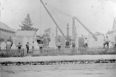
Photograph, Robson & Gray Monumental Masons in Lower Main Street
Robson & Gray Monumental Yard, Lower Main Street Stawell. Photo shows monuments, cranes and nine employees behind wooden picket fence and gate. Timber weather board buildings either side of photograph. Note Grampian Freestone and Granite gutter at front. Notes: Francis Watkins started the business which was later, during 1897 sold to two employees, George Henry Robson and George Gray. Robson & Gray carried on the business until 1923 when their partnership was dissolved. Since then the business has traded as G.H. Robson (1923 - 46) G.H. Robson and Sons (1946 - 58) and G.H. Robson and Sons, Pty Ltd. since 1958. Later to trade as Waites. Robson.Black and white photograph of a monumental mason's yard. Nine employees behind a wooden picket fence and gate. Footpath and gutter in foreground.Robsonstawell industry -
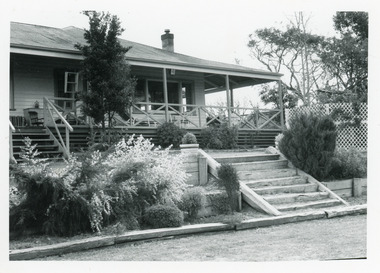 Lakes Entrance Regional Historical Society (operating as Lakes Entrance History Centre & Museum)
Photograph - Housing, 1991
... Timber Industry...Date made September 1991 Houses Timber Industry Heritage ...Date made September 1991Black and white photograph of a timber residence with corrugated iron roof, six wide steps leading from shaded veranda, native plant garden in narrow terrace with sleeper steps leading down to mowed lawn. Situated at Mill Point Road, Toorloo Arm Victoriahouses, timber industry, heritage study -
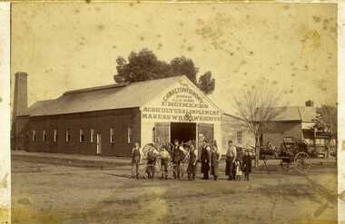 Charlton Golden Grains Museum Inc
Photograph, Clarke Bros Photographers, The Charlton Foundry c. 1890, c.1890
Charlton Foundry building est 1885 corner of Learmonth and High Sts. Residence next door. Later Dabron's Foundry.Sepia photograph, mounted unframed of The Charlton Foundry Company, Late C.Munro, Engineers, Agricultural Implements Makers, Wheelwrights etc.. Ten people standing outside, seven men, a boy with a bicycle and two young girls. Long timber building with large chimney at the rear of the building, Machinery, wheels and horse drawn vehicles on display. Clark Bros Photographers 25 Thomas St Windsor. Charlton Foundry 1890munro's, charlton, industry, business, foundry -
 Eltham District Historical Society Inc
Film - Video (DVD), Melbourne and Metropolitan Board of Works, Yarra River Conference Proceedings; a Board of Works centenary event, 13-16 April 1991
... ; pollution of the Yarra by industry; aborigines, gold miners, timber...; pollution of the Yarra by industry; aborigines, gold miners, timber ...Yarra River Conference History Segment [Noted on VHS tape jackets "Due to unavoidable circumstances, the quality of these tapes in some setions is less than desired."] The Yarra River Conference, organised by the Board of Works as part of the Centenary Celebrations, was held in the Board's Head Office Theatrette from 13-16 April, 1991. A segment of the Conference focussed on the role that the Yarra River has played in relation to the historical development of Melbourne. Conceived and presented by a group of prominent historians as a chronological 'trip down the river in time', and profusely illustrated with slides, this segment traced the various impacts that urban and rural growth, development of marine commerce, recreational uses, and environmental problems have had on the Yarra during a century and a half of European occupation. As no formal written paper of this combined presentation is available, these two video-tapes provide a record for anyone who has an interest in tis fascinating aspect of the Yarra's history. The speakers who combined to present this segment are identified on the cover of Tape 2. Tape 1 (2 hours) 1838-1863 Deputy ?? to Utility Early navigators of the Yarra River; developing the port of Melbourne; the gold rush and its effect on the new colony; punts and bridges; water supply; pollution of the Yarra; the discovery of gold and early settlement of the Yarra valley; floods of 1839 and 1863. 1863-1891 Formation of the Harbour Trust; Coode Canal; pollution of the Yarra by industry; aborigines, gold miners, timber getters in the Upper Yarra areas; bridges; the flood of 1891. Tape 2 ( 1 1/2 hours) 1892-1934: People Begin to See Beauty and Romance to the River Henley-on-Yarra; realignment of the Yarra; MMBW is responsible for a sewerage system; new docks to cope with increased overseas trade; development of recreational parks; new reservoirs; timber production and timber tramways; bushfire; flood of 1934. 1935-1970: The River is Neglected Still, Except When it Proves Useful Bushfirs of 1939; the end of many sawmills; birth of tourism; increased interest in conservation and preservation of land for open space; further augmentation of water supply system; birth of containerisation changes the port; environmental concerns gain momentum. Speakers Dr Tony Dingle *, Department of Economic History, Monash University Dr Carolyn Rasmussen *, History Consultant Prof. Graeme Davison, History Department, Monash University Mr. Tom Griffiths, Lecturer in Public History, Monash Uiversity Mr. Patrick Miller, History Consultant Mr. Colin Jones, Author and Historian * Co-authors of the Board's history, 'Vital Connections'.video recording, yarra river, conference proceedings -
Lakes Entrance Regional Historical Society (operating as Lakes Entrance History Centre & Museum)
Book, Meadley, Irene, Sawmill Flats/Fishermen's Cottages Sites, Nyerimilang Park, 2002
... Timber Industry...Fishing Industry Aboriginals Timber Industry Research ...Research, interpretation and management recommendations for the Sawmill Flats/Fishermen's Cottages Sites at Nyerimilang Park, Nungurner, East Gippsland, Victoria, by Forestec Student.fishing industry, aboriginals, timber industry -
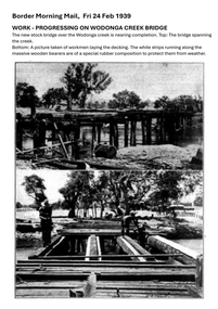 Wodonga & District Historical Society Inc
Photograph - Wodonga Creek Stock Bridge Collection
The Wodonga Creek Stock Bridge was constructed by the Country Roads Board in 1939. The date was recorded on a small plaque attached to one of the trestles. The bridge is an important reminder of one of the industries Wodonga was built on — cattle. It was constructed to develop a new stock route between Albury and Wodonga which would direct cattle away from the main bitumen roads and traffic bridges to the Wodonga Saleyards, where thousands of sheep and cattle were sold each month. It is a moderately tall timber trestle road bridge consisting of nine spans, with a deck length of 76 metres and deck width of 4.5 metres, and a maximum span length of 8.5 metres. The substantial timber deck featured decking laid horizontally and longitudinal running planks laid on top of it. The bridge also has timber side safety rails to discourage livestock from straying over the side. The bridge also became the centre of summer social activity for the young people of Wodonga as the area became a gazetted swimming area before the Wodonga Swimming Pool was constructed in 1959. In 1980 the Wodonga Saleyards were relocated to Bandiana to the east of the city. This meant that Wodonga Creek Stock Bridge was no longer needed for its original purpose. Although listed as a significant site by the Victorian Heritage and National Heritage Trust on 3/08/1998, the bridge fell into disrepair and also suffered damage from several floods. A suspension Bridge was constructed beside the Stock Route Bridge in 2013 and the old bridge was closed to traffic. Major damage caused by several floods, including a major flood in 2022 has resulted in the bridge being unsafe and its future is uncertain. The model of the Wodonga Creek Stock Bridge in our Collection made by Mr John Wild, depicts its current condition.The Wodonga Creek Stock Bridge is significant for technical, historic and social reasons and has been registered at the State Heritage level. It is of technical significance as a nine span bridge with tall timber trestles. Large bridges of this type are now very rare in Victoria. It is of historic significance as a surviving structurally authentic bridge designed specifically for livestock and drover use, on a historic stock route. The Stock Bridge is of social significance for its location at a popular riverside leisure spot since its construction in 1939.A collection of photographic images depicting the Wodonga Creek Stock Bridge. It contains both black and white and coloured images taken at different times in the Stock Bridge's history. A model of the Bridge made for Our Society is also included.wodonga creek stock bridge, wodonga heritage -
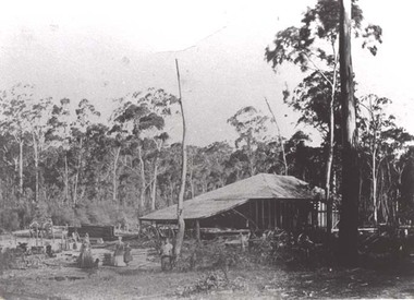 Stawell Historical Society Inc
Photograph, Saw Mills at Childe’s Glenbower Creek in Halls Gap 1866
Saw Mills Halls Gap (Childe’s Glenbower Creek). Part of a collection of Photographs by Mr. O.G. Armstrong as commissioned by the Shire of Stawell for the Inter-colonial and Paris Exhibition in Melbourne in 1866. During the years of gold, the hardwood forests around Stawell were ravaged to provide timber for the mines. It was used undergrounds to shore up workings, and millions of feet of it were fed into furnaces and kilns in which the quartz was roasted. In the years after the gold boom, hardwood from the Grampians was milled for building timber. Wherever there are large tracts of natural bushland, fires are always a danger. A huge fire in January 1939 caused havoc in the Grampians, burning out towns and sawmills such as the one pictured. There have been no sawmills in the Grampian since that fire. stawell industry -
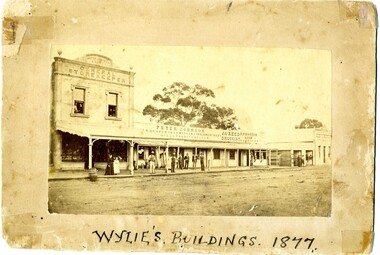 Charlton Golden Grains Museum Inc
Photograph, Wylie's Buildings 1877, c. 1877
Earliest known photo of the stores. Johnson's Bridge store built 1873. Procter's c. 1876. Western end, left hand side of High Street, Charlton. Earliest known photo of the storesPhotograph of Peter Johnson's Bridge Store High St Charlton. Titled Wylie's Buildings 1877. Group of people on footpath. Peter Johnson's store, Reed Chemist shop, Procter's Butcher shop, Bank of New South WalesWylie's Buildings 1977peter johnson a.d. 1877 general storekeeper, peter johnson, draper, iron monger, timber merchant, general produce, jas reed, druggist, butcher, r procter & son, business, industry