Showing 2474 items
matching township
-
 Lakes Entrance Historical Society
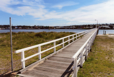
Photograph - Footbridge, 2008
Date made August 2008|This is the paired after photograph used in the 150 year Lakes Entrance 1858 - 2008 display.Colour photograph of the footbridge crossing Cunninghame Arm waterway, the township is in the foreground, Lakes Entrance, Victoria.bridges, waterways, township -
 Lakes Entrance Historical Society
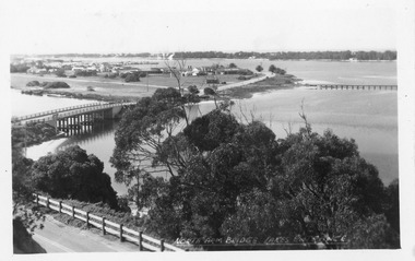
Postcard - North Arm bridge Lakes Entrance Victoria, 1950c
North Arm Bridge Lakes Entrance. (on back holidays 1951)Also 1x tinted photographic postcard identical scene 01162-2 good conditionBlack and white postcard of the North Arm bridge, lakes and western section of township, sand hummocks in distance. Lakes Entrance Victoriabridges, township -
 Lakes Entrance Historical Society
Book, Rule Hilda, Back to Nowa Nowa, 1980
A short history of the timber township of Nowa Nowa, East Gippsland Victoria.township, settlers, timber industry, schools, transport -
 Orbost & District Historical Society
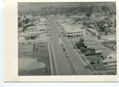
black and white photographs, C 1960s - 1970s
3290.1 is an aerial photograph of the township of Orbost looking south along Nicholson Street. The tennis courts and recreation reserve are on the left. The War Memorial, Commonwealth Hotel at the Saisbury Street intersection is in the centre of the photograph. 3290.2 is an aerial view of the Orbost township looking north, showing the bridge across the Snowy River in the foreground,These photographs are detailed pictorial records of the Orbost township C 1960s - 1970s.Two photographs which are aerial views of a township showing streets, buildings and vehicles. 3290.1 is a black / white photograph. 3290.2 is a coloured photograph.orbost-township-c1960s-1970s aerial-photograph-orbost -
Lakes Entrance Historical Society
Book, Maddern I T, Shire of Rosedale Centenary 1871-1971, 1971
The history of the Rosedale Shire written for the centenary in 1971 includes history of the township schools churches cemetery and the original settlers who developed this region of Victoria.township, settlers -
 Bendigo Historical Society Inc.
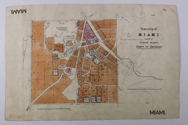
Map - MIAMI ( MIA MIA), 26/06/1906
The name Miami on the is a misprint Map: Township of Miami (Mia Mia), Parish of Spring Plains, County of Dalhousiemap, dalhousie, township, mia mia, spring plains creek -
Bendigo Historical Society Inc.
Map - TOWNSHIP OF HEATHCOTE SHEET 2, Circa 1935
Map: Township of Heathcote sheet 2. Parish plan (number 254 in map cupboard 1)map, dalhousie, township, heathcote -
 Rutherglen Historical Society
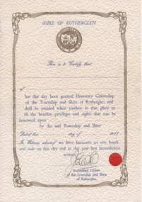
Certificate, 1973
One of the items which would have been presented to a relative of the donor when he was visiting Rutherglen Scotland in 1974.Decorative certificate, printed in blue and gold on textured paper, from the President, Councillors & Ratepayers of the Shire of Rutherglen. Space for the name of the recipient of the "Honorary Citizenship of the Township and Shire of Rutherglen" has been left blank as has the month and day of 1973 for the presentation.At the bottom of the certificate, there is an illegible signature above the words "Accredited Citizen of the Township and Shire of Rutherglen", along with a small red seal. rutherglen scotland, royal burgh of rutherglen -
 Clunes Museum
Photograph
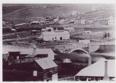
BLACK & WHITE PHOTOGRAPH GENERAL VIEW CLUNES TOWNSHIP WITH GOVERNMENT BRIDGE IN CENTRE OF PHOTOGRAPH, EBERHARD SOFT DRINK FACTORYphotographs, township, goverment bridge -
 Lakes Entrance Historical Society
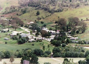
Photograph - Buchan, Tambo Shire, 1994 c
Also second identical copyColour photograph of the township of Buchan, taken from a high point above the town which is situated in a valley with hills rising on all sides. Buchan Victoriatownship, topography -
 Orbost & District Historical Society
black and white photograph, February 1971
This photograph is an aerial view of the township of Orbost taken by the Bairnsdale Advertiser newspaper. It was taken from the northern end of the town. The 1971 flood was the the worst flood on record. At Jarrahmond it was at least 11 metres and up to one and a half kilometres wide on the flats causing enormous damage to the flood plain. Records say that "The brown floodwater stain in Bass Strait could be seen from passing airliners." Considerable damage was done to railway infrastructure, roads and farms. More information from the APRIL, 2008 newsletter by John Phillips. (see orbosthistory.com.au)This is a pictorial record of a significant event in the history of Orbost,A black / white aerial photograph of a township with floodwaters in the background.on back - "Note main current through the lagoon 1971."orbost-floods-1971 bairnsdale-advertiser orbost-township -
Whitehorse Historical Society Inc.
Map, A Plan of part of the Parish of Nunawading, 1984
Hand drawn plan showing the owners or occupiers of land c1860'.Hand drawn plan showing the owners or occupiers of land c1860'. Includes proposed townships of New Brunswick and Norwich. Scate 1 inch : 10 chains.Hand drawn plan showing the owners or occupiers of land c1860'. maps, shire of nunawading -
Bendigo Historical Society Inc.
Map - HARCOURT, No date visible
Map: Township of Harcourt, Parish pf Harcourt, County of Talbot, (number 265 in map cupboard 1)map, talbot, township, harcourt -
 Buninyong & District Historical Society
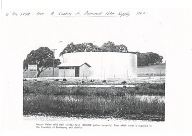
Photograph - Copy of a publication depicting Mount Helen water tank 1958, Mount Helen water tank 1958
This image depicts the opening of the permanent water supply for the Buninyong Township and District in 1958 for Buninyong Water TrustThis image illustrates the turning on the valve for the first permanent water supply to Buninyong in 1958A black and white photocopy of a photo showing the 500,000 gallon capacity water tank at Mount HelenMount Helen mild steel storage tank, (500,00 gallons capacity) from which water is supplied to the Township of Mount Buninyong and district.buninyong water trust, buninyong water supply, mount helen water storage tank -
Whitehorse Historical Society Inc.
Document, What happened to Norwich?
Norwich, consisting of 475 acres in the Parish of Nunawading, County of Bourke, found on a land sale map in the La Trobe collection of Vale maps.Norwich, consisting of 475 acres in the Parish of Nunawading, County of Bourke, found on a land sale map in the La Trobe collection of Vale maps. Research by Jean Uhl into the fate of the proposed township.Norwich, consisting of 475 acres in the Parish of Nunawading, County of Bourke, found on a land sale map in the La Trobe collection of Vale maps. local history, uhl, jean, parish of nunawading, norwich village, vermont, lobb, john, graham, thomas -
Bendigo Historical Society Inc.
Map - RAYWOOD, 18/09/1930
Map: Township of Raywood, Parish of Neilborough,County of Bendigo. Parish plan (number 270 in map cupboard 1)map, bendigo, township, raywood -
Bendigo Historical Society Inc.
Map - RAVENSWOOD, April 6th 1872
Map: Township of Ravenswood. Parish plan, has a 1913 calendar as a backing (number 266 in map cupboard 1)map, bendigo, township, ravenswood -
Bendigo Historical Society Inc.
Map - YARRABERB, 17/12/1937
Map: Township of Yarraberb, Parish of Yarraberb, County of Bendigo. Parish plan (number 274 in map cupboard 1)map, bendigo, township, yarraberb -
Bendigo Historical Society Inc.
Map - NEWBRIDGE, August 17th 1875
Map: Township of Newbridge, Parish of Tarnagulla, County of Bendigo. Parish plan (number 272 in map cupboard 1)map, bendigo, township, newbridge -
Bendigo Historical Society Inc.
Map - AXEDALE, 12/07/1909
Map: Township of Axedale, Parish of Axedale, County of Bendigo. Parish plan (number 271 in map cupboard 1)map, bendigo, township, axedale -
Bendigo Historical Society Inc.
Map - ELMORE, 7/08/1911
Map: Township of Elmore, Parish of Elmore, County of Bendigo ( number 159 in Map Cupboard 1)map, bendigo, township, elmore, county of bendigo -
Bendigo Historical Society Inc.
Map - GOORNONG, 1/10/1906
Map: Township of Goornong, Parish of Goornong, County of Bendigo ( number 154 in Map Cupboard 1)map, bendigo, township, goornong, county of bendigo -
 Lakes Entrance Historical Society
Postcard - View of Bruthen, W S Vogt Bairnsdale, 1918 c
Black and white postcard showing township, roads and rail, bridges and barked trees with cultivated land beside Tambo River Bruthen VictoriaTambo River at Bruthentownship, bridges, roads and streets -
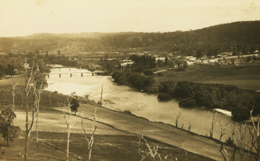
 Marysville & District Historical Society
Ephemera (Item) - Information brochure, Marysville & District Historical Society Inc, Marysville Historical Walk, 2003
An information brochure outlining a historical walk around Marysville that takes in some of the more historical sites in the township. This brochure was created by the Marysville & District Historical Society Inc in 2003. Most of the buildings, along with most of the town, were destroyed in the 2009 Black Saturday bushfires.An information brochure outlining a historical walk around Marysville that takes in some of the more historical sites in the township.marysville, victoria, australia, information brochure, 2009 black saturday bushfires -
Bendigo Historical Society Inc.
Map - TOWNSHIP OF KANGAROO FLAT, 27/01/1932
Map: Township of Kangaroo flat, Parish of Sandhurst , County of Bendigo. Parish plan ( number 194 in Map Cupboard 1)map, bendigo, township, kangaroo flat -
 Lakes Entrance Historical Society
Postcard - Lakes Entrance, Bulmer, H D, 1940c
One Black and White Photograph 6.5 x 11|Two Postcard 8.5 x 14|Two Small format postcard 6 x 9|This is the before paired photograph used in the 150 year, Lakes Entrance 1858-2008 display.|The after paired photograph number is 01156.1 Also one 12 x 16 framed photograph used in room display.Black and white photographic of bridge over North Arm showing the western end of township, sand hummock viewed in distance, Lakes Entrance Victoriatownship, bridges, room display -
 Lakes Entrance Historical Society
Photograph - Lakes Entrance, 1960c
Copied from postcardColour photograph aerial view of the township, shows also Cunninghame Arm, the hummocks and distant view of Bullock Island and the entrance. Lakes Entrance Victoria hotels, township, waterways -
 Lakes Entrance Historical Society
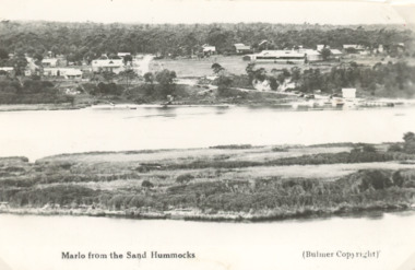
Postcard - Snowy River, H D Bulmer, Marlo Victoria, 1910 c
Black and white postcard taken from the hummocks looking across one of the low islands and the Snowy River showing view of the township of Marlo Victoriawaterways, township, islands -
Bendigo Historical Society Inc.
Map - TOWNSHIP OF LOCKINGTON, 21/09/1915
Map: Township of Lockington, Parish of Bamawm, County of Bendigo. Parish plan.Has a clipping from 'The Riverine Herald' dated 20/11/1915 on the reverse side re. the sale of blocks in Bamawm Township (number 322 in map cupboard 1)map, bendigo, township, lockington, bamawm, the riverine herald -
 Bendigo Historical Society Inc.
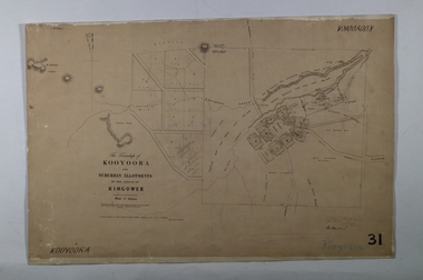
Map - KOOYOORA, July 23rd 1857
Map: The Township of Kooyoora and suburban allotments in the Parish of Kingower. This plan has been applied to a newer backingmap, township, kooyoora, allotments, parish of kingower