Showing 2422 items
matching townships
-
 Buninyong & District Historical Society
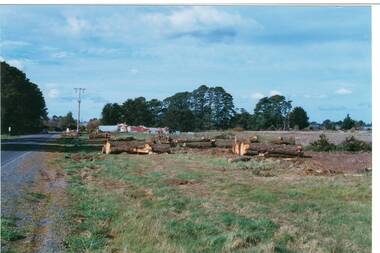
Photograph - Original Photograph, Mr. C.J. Brooks, Main street of Yendon from the West showing felled pine trees, September 1995
Social, historicalExample of the felling of trees for power company in the late twentieth centuryColour photo, of the Western outskirts of the township of Yendon showing 8-10 felled pine trees from the southern side of avenueyendon, moorabool shire, streetscape, felled pinetrees, powercor -
 Stawell Historical Society Inc
Photograph, Town Reservoir with Mr John D'alton & viewing of the township in the background
Reservoir on Big Hill (Early Scene)B/W Two males; closest has full beard in front of town reservior on Big Hill, background view of townshipstawell -
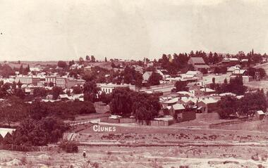
 Clunes Museum
Photograph, CLUNES, CIRCA 1973
PHOTOGRAPHS TAKEN BY F.C. WEICKHARDTCOLOURED PHOTOGRAPH SHOWING PANORAMIC VIEW OF CLUNES TOWNSHIP, MOUNTED ON BOARD WITH MOCK FRAME AROUND EDGE ON BACK HAS INSCRIPTIONPRESENTED TO TALBOT & CLUNES SHIRE COUNCIL. MAY 1973 F CONRAD WEICKHARDT 24.5. 73 CLUNES NOVEMBER 1972 TAKEN BY F C WEICKHARDTlocal history, photography, photographs, weickhardt family -
 Clunes Museum
Photograph
BLACK AND WHITE PHOTOGRAPH OF CLUNES TOWNSHIP TAKEN FROM LESLIE STREET, LOOKING SOUTH. BIBLE CHRISTIAN CHURCH IN CENTRE OF PHOTOGRAPH.FROM LESLIE STREET LOOKING SOUTH OVER BIBLE CHRISTIAN CHURCH ON C/R FRASER IN BAILEY STREET RUNNING ACROSS MID PICTURE.local history, photography, photographs, clunes township -
 Clunes Museum
Plan
PLAN HAS AN ATTACHED HAND PRINTED CARD WITH INFORMATION REGARDING SITES. THIS HAS BEEN ADDED AT A MUCH LATER DATE.1 PAGE - AN EARLY, UNDATED PLAN OF THE TOWNSHIP OF CLUNES, COUNTY OF TALBOT, SHOWING REDUCED LEVELS AND CHAIN SURVEY OF ALL SECTIONSlocal history, plans -
Whitehorse Historical Society Inc.
Document, Blackburn Township Estate, 1913
Auction of 23 villa and shop sites in the Blackburn Township estate by Coghill Haughton, Saturday 2nd August, opposite the railway station.Auction of 23 villa and shop sites in the Blackburn Township estate by Coghill Haughton, Saturday 2nd August, opposite the railway station. Auction of 23 villa and shop sites in the Blackburn Township estate by Coghill Haughton, Saturday 2nd August, opposite the railway station. blackburn township estate, coghill haughton -
Lakes Entrance Regional Historical Society (operating as Lakes Entrance History Centre & Museum)
Photograph, 1907 c
Black and white photograph of the township of Sunnyside which came into existence after gold was discovered at Mt Wills north of Omeo Victoriahistoric sites, mines and mining -
Clunes Museum
Ephemera - STICKER
Stickers are traditionally placed on vehicle to promote destination/s traveled. This sticker essentially promotes tourism to Clunes and images gives clues about the town.Coloured adhesive backed sticker on the shape of a shield. 3 x images - Clunes township, a sheep, windlass over mine shaftClunes Vicsouvenir, sticker -
 Linton and District Historical Society Inc
Photograph, Grenville Standard Building, Clyde Street, Linton
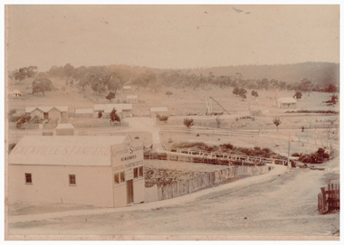
Sepia photograph of Grenville Standard building, with view of railway station and other buildings spread across open land at east of township."S E Surman".grenville standard [newspaper], buildings, linton railway station, clyde street linton -
 Lakes Entrance Regional Historical Society (operating as Lakes Entrance History Centre & Museum)
Postcard, 1950c
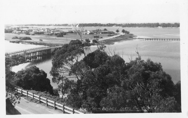
North Arm Bridge Lakes Entrance. (on back holidays 1951)Also 1x tinted photographic postcard identical scene 01162-2 good conditionBlack and white postcard of the North Arm bridge, lakes and western section of township, sand hummocks in distance. Lakes Entrance Victoriabridges, township -
Bendigo Historical Society Inc.
Map - CAMPBELL COLLECTION: BENDIGO AND DISTRICT MAPS, 21-8-1972
Map. Shire of Strathfieldsaye, Locality Plan. Scale I inch=1 mile. Shire of Huntly, Shire of McIvor, City of Bendigo, Shire of Marong, Shire of Maldon, Shire of Metcalfe. Lake Eppalock. Mileage markers on some roads. Melbourne to Bendigo Railway Line, Big Hill Tunnel, Mt.Herbert 1596.Axedale Township, Strathfieldsaye Township.M.Higgs 21-8-1972map, bendigo, locality plan -
Bendigo Historical Society Inc.
Map - CAMPBELL COLLECTION: BENDIGO AND DISTRICT MAPS, 1962
Map. Mandurang, County of Bendigo. Scale 40 chains to 1 inch. Sandhurst, Strathfieldsaye, Sedgwick, Sutton Grange, Ravenswood, Lockwood, Township of Kangaroo Flat, Township of Mandurang. By Authority A.C. Brooks, Government Printer, Melbourne. Drawn and Reproduced at the Department of Lands and Survey, Melbourne,1962, Price 2/-. (number 401 in map cupboard 1)A.C. Brooks, Government Printer.map, bendigo, allotments -
 Bendigo Historical Society Inc.
Photograph - HARRY BIGGS COLLECTION: LONG GULLY TOWNSHIP
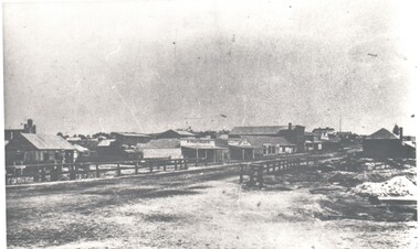
Photograph. Harry Biggs Collection. 1 black & white photo of Long Gully township looking from Eaglehawk towards Bendigo near the bridge. On 1 shop can be seen P Pentreath. A wooden bridge can be seen over the creek. Long Gully Township looking from Eaglehawk to Bendigo near bridge (written on the back).photograph, streetscape, long gully, harry biggs collection, long gully township -
 Ringwood and District Historical Society
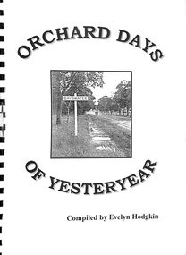
Book, Orchard Days of Yesteryear - Compiled by Evelyn Hodgkin, Bayswater, Victoria - Volume One, 1999
Brief history of Bayswater, Victoria, with memories, detailed stories and photographs of residents of Bayswater, Victoria. Cover photograph courtesy of Marj Crisp - taken outside Bayswater State School looking towards township. (c.1940s) -
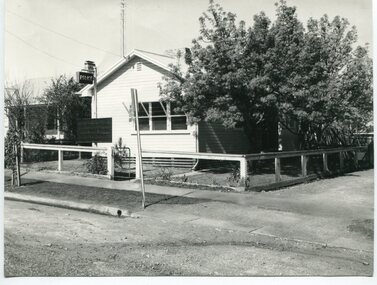 Orbost & District Historical Society
black and white photograph, 1960s - 1970s
This photograph shows the former Orbost Police Station in Wolseley Street before it was demolished and a new larger brick building was built behind it in Lawson Lane - late 1980s.This is a pictorial record of a significant community building no longer existing.A large black / white photograph of the Orbost township police station. It is a weatherboard building surrounded by trees. A sign "POLICE" is hanging from a pole.on back - " Orbost Police Station in Wolseley Street, Donated by Debbie Hall 31/8/94"orbost-police-station -
Clunes Museum
Document
.1 DAYLESFORD AND HEPBURN SPRINGS 14 PAGES, ACCOMMODATION, SITES, CHURCHES, MAPS .2 TALBOT TOWNSHIP, SHORT HISTORY AND POINTS OF INTERESTtalbot, daylesford hepburn springs, history maps points of interest -
Lakes Entrance Regional Historical Society (operating as Lakes Entrance History Centre & Museum)
Postcard, W S Vogt Bairnsdale, 1918 c
Black and white postcard showing township, roads and rail, bridges and barked trees with cultivated land beside Tambo River Bruthen VictoriaTambo River at Bruthenjetties, waterways, topography, boats and boating -
Clunes Museum
Map - MAPS
A MAP OF CLUNES TOWNSHIP. ORIGINAL AND COPY. ALL STREETS WITH ALLOTMENT NUMBERS CRESWICK CREEK - KILKENNY CREEK - BALLARAT TO MARYBOROUGH RAILWAY LINE.CLUNESlocal history, document, maps, clunes township -
 Clunes Museum
Photograph, 1911
COPY OF POSTCARD OF TOWNSHIP OF CLUNES 1911, TAKEN FROM SCENIC DRIVE, SHOWING FRASER STRRET BUILDINGS, ST PAUL'S CHURCH ETC.CLUNESlocal history, document, postcard, clunes township -
Clunes Museum
Print - DISPLAY PANEL
COPIES OF DISPLAY PANELS DONATED TO THE PEOPLE OF CLUNES BY THE HUGH WILLIAMSON FOUNDATION.1 INTERPRETIVE DISPLAY PANEL DEPICTING THE DISCOVERY OF GOLD AND THE DEVELOPMENT OF THE TOWNSHIP OF CLUNES IN A WOODEN FRAME .2 LAMINATED COPY OF THE DISPLAY PANELlocal history, civic momentoes, presentations., williamson, hugh foundation -
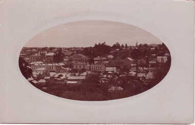 Clunes Museum
photograph
OVAL PHOTOGRAPH - POST CARD PHOTOGRAPH, OF CLUNES TOWNSHIP. .1 ORIGINAL POSTCARD, OVAL PHOTOGRAPH ON GRAY CARDBOARD .2.3 PHOTOCOPIES OF THE POSTARDlocal history, photography, photographs, clunes township -
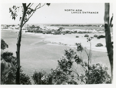 Lakes Entrance Regional Historical Society (operating as Lakes Entrance History Centre & Museum)
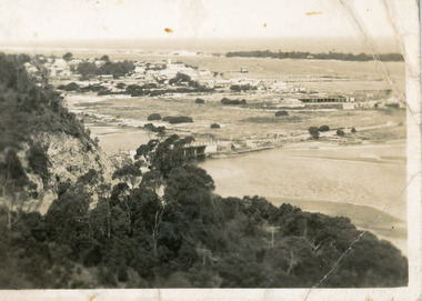
Postcard, 1945c
Photo taken soon after extensive dredging operations when tons of sand were dumped on low lying land at western end of town.Black and white small format postcard of the North Arm. It shows the township between North Arm and Cunninghame Arm. Lakes Entrance VictoriaNorth Arm Lakes Entrancewaterways, topography, fences -
 Lakes Entrance Regional Historical Society (operating as Lakes Entrance History Centre & Museum)
Photograph, Fraser, Nancy, 1970c
Black and white photograph of a distant view township and Cunninghame Arm and scrub covered hummocks of southern shore in distance. Lakes Entrance Victoriaislands, jetties, topography, waterways, roads and streets -
Lakes Entrance Regional Historical Society (operating as Lakes Entrance History Centre & Museum)
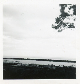
Photograph, F Cornell, 1870
Black and white photograph of the punt on the Mitchell River and the first bridge under construction. In distance can be seen the growing township of Bairnsdale Victoriaboats and boating, waterways, businesses -
Lakes Entrance Regional Historical Society (operating as Lakes Entrance History Centre & Museum)
Photograph, 1/04/1990 12:00:00 AM
There was a deluge overnight in headwaters of Mitchell and Avon Rivers so the rivers rose overnight and flooded low lying areasColour aerial photograph of Mitchell River in flood showing Clifton Waters Village in centre and township of Wy Yung near Bairnsdale Victoriawaterways -
Southern Sherbrooke Historical Society Inc.
Book - Local History, Longman Cheshire Pty Ltd, Story Of The Dandenongs, First published 1959, thisa copy reprinted 1982
pp.xv, 415, hardback, appendices, index of names. History of exploration & development,local government & services and the townships of the Dandenong Ranges, 1838-1958.dandenong ranges, local government, white settlement -
 Federation University Art Collection
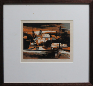
Work on paper - Artwork - Printmaking, Jack, Kenneth, 'Long Gully near Bendigo' Kenneth Jack, 1960
Framed Limited Edition print showing a mining township at Long Gully, Bendigo. Donated through the Australian Gifts Programme by Katherine Littlewood.29/40goldfields, poppet head, bendigo, long gully, tram -
 Bacchus Marsh & District Historical Society
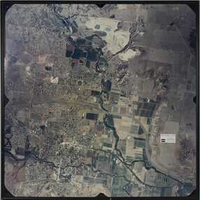
Photograph, Aerial image of Bacchus Marsh and Darley in 1994
A whole of town and nearby area aerial image of Bacchus Marsh produced for display in the Arbee Real Estate Agency premises in Main Street, Bacchus Marsh.A large framed colour aerial photograph showing the township of Bacchus Marsh, the neighbouring smaller community of Darley, and the nearby areas of both places. "Bacchus Marsh - Darley. Aerial Photo 27 November, 1994. Presented by Arbee Real Estate "Professionals"'arbee real estate agency bacchus marsh, aerial views bacchus marsh vic. -
 Lakes Entrance Regional Historical Society (operating as Lakes Entrance History Centre & Museum)
Postcard - Township, 1930c
Black and white small format postcard showing the township situated on the land between the Cunninghame Arm and North Arm. Lakes Entrance VictoriaLakes Entrance from Princes Highway (on back)bridges, township, topography, waterways -
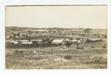 Malmsbury Historical Society
Postcard (Item), Postcard Ranters Gully Township C1910, Malmsbury c1910
Buildings - Township People - Township Ranter Gully