Showing 1049 items matching "trailes"
-
 Greensborough Historical Society
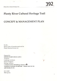
Report, Plenty River Cultural Heritage Trail : Concept & management plan, 2005_07
Prepared for the Rotary Club of Greensborough and Plenty Historical Society by Dennis Ward, this report outlines the heritage importance of the Plenty River Trail around Greensborough.This is an ongoing project by Dennis Ward. This report is an early version of the 2011 Squatters, speculators and settlers: Plenty River Cultural heritage trail. (Item 258) 66 page report, Illus, (some col.) , maps. In red 2-ring binder.Some handwritten notes in last pages.plenty river cultural heritage trail, dennis ward, rotary club of greensborough, plenty historical society, plenty river -
 Nillumbik Shire Council
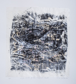
Print (woodcut and etching on chine-colle): John WOLSELEY (b.1938 Somerset, UK; arrived 1976 Melb., AUS), John Wolseley, 'Life world of the Longicorn beetle' from the 'Baldessin & Friends commemorative folio', 2016
Painter, printmaker and installation artist John Wolseley was born in Somerset, England. He lived and worked throughout Europe before relocating to Australia in 1976. His work explores how people dwell and move within landscape. Wolseley see's himself as a hybrid mix of artist and scientist; one who tries to relate the minutiae of the natural world - leaf, feather and beetle wing - to the abstract dimensions of the earth's dynamic systems. Using techniques of watercolour, collage, frottage, nature printing and other methods of direct physical or kinetic contact Wolseley finds ways of collaborating with the actual plants, birds, trees, rocks and earth of a particular place. George Baldessin was one of the first artists John Wolseley met when he arrived in Australia in 1976. Both immigrated to Australia and connected through this shared experience. They were both at 'Realities Gallery' with Marianne Baillieu in the 1970s and 80s. George Baldessin (1939-1978) was born in San Biagio di Callalta, in the Veneto in Northern Italy and arrived in Australia ten years later. A printmaker and sculptor he built his bluestone studio at St Andrews (Nillumbik) in 1971 with his partner Tess and the three Hails brothers, Rob, Doug and Don. Made of recycled materials the studio today contains all of George’s equipment including the large press, which he modelled himself with the help of Neil Jeffrey (Enjay Presses). George won many prizes throughout his career and is represented in many of Australia's public art collections including his famous 'Pears' sculpture in front of the National Gallery of Australia, Canberra. In 1975 he represented Australia in the Sao Paulo Biennale, before living and working in Paris until his return to St Andrews in 1977. In 1978 George was killed in a car accident aged 39 years. In 2001 Tess returned to St Andrews to reclaim the run-down studio and reconstitute it as The Baldessin Press & Studio - a printmaking retreat. It operates in George’s memory, so that artists may continue to create, perpetuating the generous spirit of George. 'Life world of the Longicorn beetle' is one of eight prints in the 'Baldessin & Friends commemorative folio. The folio was conceived by Tess Edwards as a fundraising initiative in celebration of the The Baldessin Press & Studio's fifteen year anniversary, and as a way to honour George Baldessin's memory. The Baldessin Press & Studio is a not-for-profit organisation created in memory of the late George Baldessin (1939-1978), whose original studio is now open to the public for creative use and as a practical legacy to living artists. The Studio is located in St Andrews, Nillumbik. The folio is a unique coming together of seven very different and acclaimed artists who are connected by their friendship to the missing eighth member, George Baldessin. Communion and collaboration with nature are central to Wolseley's practice. He assembles different drawing methods to represent a kind of inventory or document about the state of the earth. His interest is to paint the processes and energy field of the living systems of this land. 'Life world of the Longicorn beetle' is his continued exploration of Australia's natural eco-systems. The beetle attacks the eucalypt and in the process of tunnelling into the wood of the tree leaves scribbly patterns. The work celebrates the cycle of life, and the wisdom and delicacy of these creatures. This three dimensional work consisting of three layers of paper is a varied edition, offering just the slightest difference between each print, reflective of variation in nature. The found log used as a woodcut acknowledges the interconnectedness of nature and living beings; the log is not apart from the art and the beetle has become an active artistic collaborator. An intimate and layered print of a tree log with line trails from the Longicorn beetle. Patches of pink, yellow and orange watercolour placed randomly. Woodcut from found log and etching on chine-colle with water colour on Gampi (top layer), Mulberry (middle layer) and Arches (bottom layer) paper. In pencil (handwritten): low plate: left '14/25' (edition); centre 'Life world of the Longicorn beetle' (title); right 'John Wolseley' (signature); low paper: right emboss 'GB' (Baldessin Press & Studio monogram)woodcut, etching, chine-colle, landscape, environment, longicorn beetle, print, baldessin, ekphrasis2018, eco, mixed media -
 Australian Army Museum of Western Australia
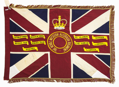
Queen's Colour - 16th Battalion, The Royal Western Australia Regiment
Presented to 1st Battalion, The Royal Western Australia Regiment by Field Marshall HRH The Prince Phillip, Duke of Edinburgh at a parade held at the Western Australian Cricket Association Ground, East Perth on 25 November 1962. The Royal Western Australia Regiment was formed on 1 July 1960 from the amalgamation of all existing infantry battalions in the State at the time :- • 11th/44th Infantry Battalion (The City of Perth Regiment) • 16th Infantry Battalion (The Cameron Highlanders of Western Australia) • 28th Infantry Battalion (The Swan Regiment) At the above presentation of colours to the new battalion, the Colours of the former battalions (four sets of Queen's and Regimental colours) were trooped through the ranks of the battalion and marched off the parade for the last time. These former colours were subsequently laid up in the undercroft at the State War Memorial, King's Park on 29 November 1964. These were transferred to the Army Museum of WA in 1988 as part of the Bicentenary Colours Project. (Refer to Items 4-12 for individual records of these colours) 1st Battalion, The Royal Western Australia Regiment was renumbered 16th Battalion effective from 1st January 1966 as part of a move to reintroduce the old battalion numbers back into the State Regimental system. 16th Battalion, The Royal Western Australia Regiment was presented with a new set of Colours on 27 October 2002. The original 1962 Colours were formally handed over for safe keeping to the Army Museum of Western Australia on 3 November 2002. Battle Honours allocated to the State Infantry Regiments created under the CMF reorganisation in July 1960 were promulgated in Australian Army Order 85/1962. These were a consolidation of the battle honours awarded to the various individual battalions that were amalgamated to form the new regiments. Union flag with gold fringes. In the centre a circle inscribed "THE ROYAL WESTERN AUSTRALIA REGIMENT", surmounted by the Crown. Battle honours emblazoned on the colour : CAPTURE OF TOBRUK, DEFENCE OF TOBRUK, EL ALAMEIN, DAMOUR, BRALLOS PASS, KOKODA TRAIL, LAE-NADZAB, LIBERATION OF AUSTRALIAN NEW GUINEA, BORNEO, LABUAN -
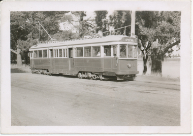
 Ballarat Tramway Museum
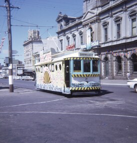
Slide - 27 mm sq slide/s - set of 2, Andrew Howlett, No. 21 as Begonia Festival Show Boat, Feb. 1969
Yields information about Sturt St and the Begonia Festival Showboat tram of 1969.Set of two Colour slide, Kodak white cardboard mount, developed Mar 1969 of No. 21 as Begonia Festival Show Boat passing the Town Hall with the destination of Gardens via Drummond St. .2 - trailing photo - with the Coles and Fletcher Jones stores in the background. Advertising the 1969 Begonia Festival. ballarat, tramways, trams, begonia festival, decorated trams, sturt st, city, tram 21 -
 Ballarat Tramway Museum
Photograph - Digital image, Wal Jack, 13/04/1956 12:00:00 AM
Yields information about how the trailing of bogie trams once work to make them ready for Ballarat was completed.Digital image from the Wal Jack Ballarat Album of photographs of Ballarat No. 41 - see Reg Item 5341, on its first trial run in Wendouree Parade, 13-4-56. Has Lake Wendouree in background and is showing Special. See image i2 for rear of photograph. On rear in blue ink "SEC Ballarat No. 41 ex Geelong 39 on 1st trail run Wendouree Parade 13-4-56" with Wal Jack stamp in top right hand corner with number "T235" written in.trams, tramways, delivery of tramcars, bogie trams, depot, commissioning, tram 41 -
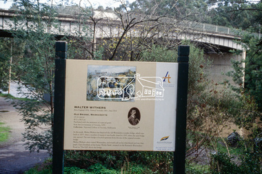 Eltham District Historical Society Inc
Slide - Photograph, Old Bridge, Warrandyte, Walter Withers, Heidelberg School Artists Trail, Warrandyte, c.2004
The Heidelberg School Artists' Trail extends from Heidelberg through Eltham and Warrandyte and to the Dandenongs. It features signs depicting paintings of artists in the location in which they were painted. 35mm colour positive transparency Mount - white 7 dots (Technodia Italy)heidelberg school artists trail, old bridge, public art, walter withers, warrandyte, warrandyte bridge -
 Tatura Irrigation & Wartime Camps Museum
Book, Seeking the Sydney. A Quest for Truth, 2005
Written to struggle to piece together a labyrinth of facts, theories and in many cases, elusive false trails. Strange cryptograms, hearsay and new evidence from German survivors.White hard cover book with dust cover, front is black and white featuring " The waiting woman and dome of souls at Geraldton, "Sydney" Memorial". Back cover is blue and white featuring Wall of Rememberancehmas sydney, geraldton western australia, hmas sydney memorial -
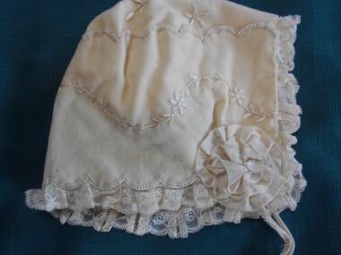 Bendigo Historical Society Inc.
Clothing - INFANT'S CREAM COLOURED BABY BONNET
Clothing. Infant's cream coloured brushed cotton bonnet. Bonnet embroidered with trailing vines and leaves, flowers and scallop pattern. Edges of bonnet are scalloped with embroidered edges and pleated lace trim (2 cm) silk ribbon rosettes on each corner with silk ribbon ties. Fully lined with silk fabric.costume, children's, infant's cream coloured baby bonnet -
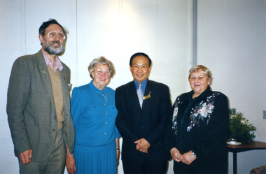 Whitehorse Historical Society Inc.
Photograph, Historical Society Presidents & Mayor, 1/08/2002 12:00:00 AM
Coloured - William Orange: President, Box Hill Historical Society; Valmae Fell: President, Burwood Historical Society; Robert Chong: Mayor, Whitehorse City Council; Judith Fry: President, Nunawading & District Historical Society. At afternoon tea given by Whitehorse City Council for contributors to Heritage Trails brochures.orange, william, box hill historical society, fell, valmae, burwood history group, chong, robert, city of whitehorse, fry, judith, nunawading & district historical society, heritage trails, brochures -
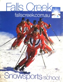
 Falls Creek Historical Society
Magazine - Falls Creek 1994 Ski Holidays
Part of an annual marketing campaign, this booklet was designed to provide information for planning a holiday at Falls Creek for the winter of 1994. It includes extensive details about activities, facilities and accommodation in the Village as well as contact information to make necessary bookings. The slogan adopted for 1994 was "Better snow and more of it!"This item is important as it documents seasonal activities at Falls Creek Alpine ResortMagazine titled 'Falls Creek 1994 Ski Holidays' containing multiple pages of information and images for 1994 winter holidays. Front cover with white background and illustration of woman skiing downhill, the 's' of Falls becoming the snow trail. Falls Creek logo on bottom centre of front page and advertising on backpage. falls creek marketing, falls creek 1990s, falls creek village, snow resorts victoria -
 Falls Creek Historical Society
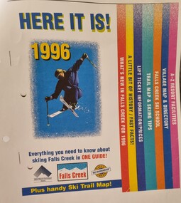
Booklet - Falls Creek Guide 1996 - HERE IT IS!
Falls Creek Resort Management produce a range of marketing materials for each season. This publication titled "HERE IT IS!" aims to include everything you need to know about skiing at Falls Creek in one guide. It also included a Ski Trail map. Sections included are:- What's new in Falls Creek for 1995 A little bit of History/fast facts Trail map and skiing tips Falls Creek Ski School Village map and directory A - Z Resort facilitiesThis item is significant because it illustrates how Falls Creek has been marketed and promoted over time.A coloured publication including images, maps and text covering all aspects of Falls Creek for the 1996 season. The cover features an image of a skier in the air. Seven sections are colour coded on the right hand edge of At bottom of page logos are included Left to right;- Alpine Resorts Commission Victoria; Falls Creek: Falls Creek Ski Guaranteefalls creek facilities, falls creek activities, falls creek marketing -
 Eltham District Historical Society Inc
Slide, Construction of Eltham Town Park, 22 Feb 1974
Construction of Eltham Town Park, later renamed Alistair Knox Park. In the foreground is where the Diamond Creek Trail runs along the creek and in the distance is the Bridge Street bridge.35 mm colour positive transparency Mount - Agfacolor Service (Blue)alistair knox park, eltham town park, bridge street bridge -
 Eltham District Historical Society Inc
Slide, Construction of Eltham Town Park, 22 Feb 1974
Construction of Eltham Town Park, later renamed Alistair Knox Park. View looking towards Bridge Street and shows the Diamond Creek and formation of the Diamond Creek Trail.35 mm colour positive transparency Mount - Agfacolor Service (Blue)alistair knox park, eltham town park, bridge street bridge, diamond creek -
 Eltham District Historical Society Inc
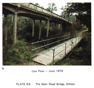
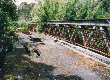
Work on paper (Sub-Item) - Photograph, Main Road Bridge, Eltham low flow of Diamond Creek, June 1979
Colour photograph.Main Road Bridge, Eltham low flow of Diamond Creek with wooden pedestrain bridge constructed over the creek as a continuation of the walking and biking trail, June 1979diamond creek, eltham, bridge, main road, pedestrain bridge, trail -
 Greensborough Historical Society
Photograph - Digital image, Dennis Ward, Axle in situ at Partington's Flat, 27/03/2010
This axle is believed to be from one of the vehicles (possibly a jinker) used by the Partington family on the Willis Vale property. It is shown after being uncovered near the Plenty River trail.From a Greensborough pioneer familyDigital copy of colour photograph.partington family, willis vale -
 Heidelberg Golf Club
Book, Melbourne Parks and Waterways, Lower Plenty River concept plan: Maroondah Pipe Track to Yarra River, 1994
Lower Plenty River concept plan: Maroondah Pipe Track to Yarra River. Includes suggestion of Plenty River Trail along the west boundary of the Heidelberg Golf Club.66 p., illus., colour map. Also, Draft copy of document.plenty river trail, lower plenty river, heidelberg golf club, mmbw, melbourne parks and waterways -
Tatura Irrigation & Wartime Camps Museum
Painting - Painting, Oil, Centaur, 1945
Harry Gorry bid for & purchased on internet auction site. The seller's mother was putting these & other items up for auction. Her father, the seller's grandfather was Dr. Bruno Koenig, a German surgeon detained by Allied forces while fleeing New Guinea in 1941. He was detained & sent to be interned in Camp 3, Tatura. There he met the painter Cesare Vagarini & they became friends, thus 4 years later upon the end of the war Vagarini gave the surgeon the two paintings in thanks & in memory of their friendship. Dr Koening then passed the paintings down to his daughter, where they remained in the family for 60 years. The seller's mother decided it was time to sell & was happy that the paintings went to a good home, as the family was until now unaware of the connection between Vagarini and the Tatura Museum. Harry Gorry just happened to notice a familiar name in an auction that he came across by accident & purchased them for our benefit. (Most information copied from Tatura Bulletin article, April 2014).Oil painting, depicting mythological scene. Female figure (unclothed), holding a red cloth/ garment trailing behind her. Centaur / faun? walking beside her. Outdoor scene. Trees, mountains & cloudy blue sky visible in background. Sandy coloured soil. Painted on reverse of old "Choice Tea" box.(On back): 1945 Tatura; ... remember ..... and us, Cesare and Maria Vagarini; On back, on sticker: Va(r)garini, Tatura Internment Camp, 1945 "Choice Tea" stencilled on back, part of original box material.tatura, camp 3, cesare vagarini, camp 3 artwork, victorian internment camps, doctor bruno koenig -
 Falls Creek Historical Society
Booklet - Falls Creek Snowsports School Information and Trail map 2002
Part of yearly marketing and information material promoting the Falls Creek Ski School. This publication includes detailed information about the Falls Creek Snowsport School Program for 2002. An introduction by the School Director, Benny Pregenzer states "Our motto is improving our guests skiing and boarding in a fun and safe environment. The most important facets of a good instructor are patience and empathy. These are qualities that our instructors display in every lesson and together with successful teaching methods, will ensure you experience fast improvement. Our instructors are carefully selected from Australia and all over the world to provide the highest quality service possible. Have a great holiday and see you on the slopes." The brochure bears the logo of Nursing Australia, proud sponsors of the Falls Creek Snowsport School.This item is important because it documents seasonal activities at Falls Creek Snowsport School in 2002.A glossy booklet featuring images and information about programs to be offered at Falls Creek in the 2002 winter season. The front cover features a group of downhill skiers while the back cover is illustrated with an image of a female snowboarder. Coloured images are included throughout the booklet. The centre page includes a map of trails at Falls Creek.On front cover Falls Creek and the resort Logo fallscreek.com.au Snowsport Schoolfalls creek marketing, falls creek ski academy, falls creek race club, falls creek snowsport school. -
 Greensborough Historical Society
Newspaper Clipping, Diamond Valley Leader, Vision for golf site, 02/08/2017
La Trobe University has broken its silence over the future of Strathallan Golf Course, revealing a vision for the land that includes residential development, sports facilities and bike trails.News article 1 page, black text.strathallan golf club, la trobe university, darebin council, bundoora -
 Eltham District Historical Society Inc
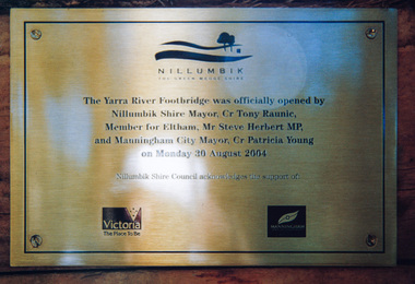
Photograph, Doug Orford, Completion of bridge works across Yarra River at rear of Eltham Lower Park, August 2004
Plaque commemorating the opening of the Yarra River Footbridge opened by Nillumbik Shire Mayor Cr. Tony Ranuic, Member for Eltham, Mr Steve Herbert MP, and Manningham City Mayor, Cr. Patricia Young on Monday 30 August 2004. Nillumbik Shire Couuncil acknowledges the support of the Victorian State Government and City of Manningham. The footbridge links the Diamond Creek Trail between the Shire of Nillumbik and City of Manningham. It is a shared pathway and also links with the Main Yarra Trail. It affords lovely views over the Yarra River.One of three colour photographsbridges, yarra river, eltham south, eltham lower park, lenister farm, homestead road, plaque, yarra river footbridge, steve herbert, tony ranic, patricia young -
Beechworth Honey Archive
Map- Albury
Map centred on Albury, showing Wodonga, Beechworth, Yackandandah and Chiltern. Topographic survey scale 1:100,000. Map is colour, printed on paper. Produced by Department of Minerals and EnergySheet 8225 (ed.1) series R. 652 Notes written on side regarding brigade boundaries, constructed access roads and fire trails, dams suitable for quick fill pump and areas 'fuel reduction burns Autumn 76'.map, albury, wodonga, beechworth, yackandandah, chiltern, paper, topographic, beechworth honey -
 Eltham District Historical Society Inc
Book, D. Pendavingh, Yarra River Trail Plan 1989: Banksia Street to Warrandyte, 1989
Also contains a loose A3 mylar plan inserted - Depart of Planning and Urban Growth, Heidelberg; Main Yarra Trail; Warringal Parklands and Banyule Flats, Detail Plan and Locality Plan -
 Eltham District Historical Society Inc
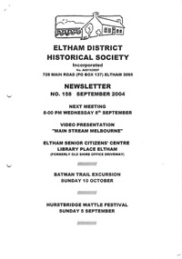
Newsletter, Newsletter, No. 158 September 2004
Contents: • Next meeting, Video Presentation: Main Stream Melbourne • September Meeting • Batman Trail Excursion • President’s Notes • Alan Marshall’s Bungalow • Hurstbridge Wattle Festival • News in Brief The Shire of Eltham Historical Society was formed in October 1967. The first newsletter of the Society was issued May 1978 and has been published continuously ever since on a bi-monthly basis. With the cessation of the Shire of Eltham in late 1994, the Society's name was revised to Eltham District Historical Society and this name first appeared with issue No. 103, July 1995. The collection of the Society's newsletters provides a valuable resource on the history of the Society's activities, office bearers and committee members, guest speakers and subjects of historical interest pertinent to the former Shire of Eltham and the Eltham District.A4 photocopied newsletter distributed to membersnewsletter, eltham district historical society, shire of eltham historical society -
 Eltham District Historical Society Inc
Photograph, Doug Orford, Lower Plenty Bridge, Old Eltham Road, Lower Plenty, 1998
Originally the boundary between the former Shire of Eltham and the City of Heidelberg, a toll gate existed on the Eltham side. The bridge has since been restored and is now part of the Plenty River Trail.Two colour photograph prints 10 x 15 cm (2 copies)bridges, lower plenty, main road, plenty river, old eltham road -
 Stawell Historical Society Inc
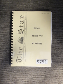
Book, Pamela Dunn, News From The Pyrenees, 2015
Transcribed from the Ballarat "Star" covering the period between 7 March 1859 and March 5th 1863 and follows the Gold Trail in the Pyrenees. Prepared on behalf of the Landsborough District Historical Society.Yellow page behind clear plastic cover Title running vertically on left The Star Vol. No. 108] Ballarat Monday, May 2 1859 [Price sixpence News From the Pyreneesstawell -
 Eltham District Historical Society Inc
Photograph, Fay Bridge, Diamond Creek in flood at the Bridge Street Bridge, Eltham, c.2004
View looking southeast from Alistair Knox Park (west). The Diamond Creek Trail footbridge is completely submerged. Significant flood events occurred Nov-Dec 2004 and Jan-Feb 2005.fay bridge collection, 2004, bridge street bridge, diamond creek (creek), floods, floodwater -
 Greensborough Historical Society
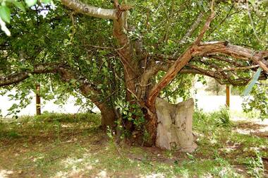
Photograph - Digital Image, Batman Apple Tree 2018, 2018_
The Batman apple tree is located on the Plenty Trail north of Greensborough. The tree dates from the mid 1800s and is said to have been purchased from John Batman's estate after his death.Digital copy of colour photographbatman apple tree, john batman, plenty river trail -
 Monbulk RSL Sub Branch
Book, Robyn Kienzle, The architect of Kokoda: Bert Kienzle - the man who made the Kokoda trail, 2011
Biography of Bert Kienzle who established a trail across the Owen Stanley ranges.Index, bibliography, ill (plates), p.327.non-fictionBiography of Bert Kienzle who established a trail across the Owen Stanley ranges.kienzle herbert thompson 1905-1988, kokoda trail (papua new guinea) -
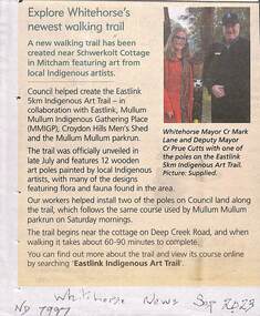 Whitehorse Historical Society Inc.
Article, Indigenous Art Trail, Sep 2023
A new walking trail has been created near Schwerkolt Cottage featuring indigenous art.non-fictionA new walking trail has been created near Schwerkolt Cottage featuring indigenous art.eastlink indigenous art trail, eastlink trail, mullum mullum creek, croydon hills men's shed -
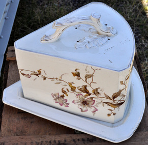 Bendigo Historical Society Inc.
Domestic Object - CHEESE PLATTER: CERAMIC
Cheese Platter - Ceramic (previously #89a and b from Mechanics Institute Eaglehawk). Wedge shaped plate and cover decorated with trail of leaves, flowers and vine. White, brown and silver. Approx 30cm x 20cm x 10cm . Makers Mark appears under plate. Two eyes with mouth. See Image 064-DSC_1009.jpgtwo eyes with mouthcottage, miners