Showing 365 items matching "white settlement"
-
 Surrey Hills Historical Society Collection
Photograph, Muriel Pornitz (deceased), Quarry on site of Grovedale Road - James Street Park
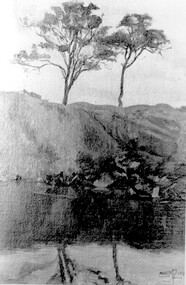
The photo is of a painting of the dam formed on land between Grovedale Road and James Street, Surrey Hills. It was painted in 1927 by Miss Muriel Pornitz, an art teacher, who lived in Grovedale Road. The land had been part of Mr James Maling Snr’s property and in the 1880s clay was removed to build houses, including his own located on the corner of Weybridge and James Streets. Maling grazed cattle on this area and used it as a dam. The land was subsequently made into parkland, the quarry / dam having been filled in after several drownings had occurred in the 1920s/1930s. See also SHP94, another copy of the same. Muriel Hedwig Lucy Pornitz lived at 22 Grovedale Road, Surrey Hills. She was born c1894 in Balwyn; died in Kew on 1 December 1982. She was the daughter of Konrad Pornitz (1864-1903) and his wife Charlotte Richardson Gooderidge (1863-1942), known as Tottie, who married in 1890. Konrad Pornitz is listed in the 1892 directory as living in Edgevale Road, Kew and the business Pornitz and Ross at 291 & 293 Little Collins Street, importers and commission merchants. The 1896 directory gives the Kew address as 176 Edgevale Road, Kew, however the business Pornitz and Ross was dissolved on 1st day of October 1892, by mutual agreement. Legal notice advised that: Mr Pornitz will hereafter carry on the business on his own behalf at the same address, under the style "Pornitz and Ross". Muriel is buried in Box Hill Cemetery (B-086-0042) along with Ulrich Horst Holm Pornitz known as Horst or Bon (d 1957) and Edith Olga Pornitz (d 1951), her brother and sister. A further sibling (Konrad b 1891) died in infancy. He is buried with his mother in Boroondara (Kew) Cemetery - C/E A 0366. Konrad died at his home 'Yarran' in Lane Cove Road, North Sydney on 31 October 1903; reported in the Sydney Morning Herald. Buried Gore Hill Cemetery, St Leonards, North Sydney. The headstone reveals he was born in Chemnitz, Saxony in 1863. Muriel was also known as Muriel Pornett. She studied at the South Australian School of Arts & Crafts in 1911 under James Ashton and Fred Britton, and at the Australian School of Etching in Sydney. She was also an illustrator and cartoonist. The photo, and the painting from which it is derived, documents the landscape prior to close settlement and is material to early building and farming in the Surrey Hills area.A black and white photograph of a painting of a landscape of parkland. Two trees are on top of a rise and are reflected at the bottom in water. The signature of the artist is in the bottom right corner: "AUST MP 192" (and the rest is cut off).(miss) muriel pornitz, grovedale road, james street, surrey hills, artists, parks and reserves, (mr) john butler maling, snr, quarry, dam, (miss) muriel hedwig lucy pornitz, box hill cemetery, muriel pornett -
 Surrey Hills Historical Society Collection
Photograph, Grovedale Road Quarry in the 1920s - looking south, c1920
The quarry was part of John Butler Maling's property. He was one of the original settlers of the area and farmed the area between Weybridge Street and Whitehorse Road. Clay was quarried from part of this area and used to make the bricks used in the construction of his home, known as 'Ancyra'. This is still extant at the corner of Weybridge and James Streets. Maling grazed cows and used the quarry as a water source. He was the uncle of John Butler Maling, Mayor of Camberwell. He was married to Kate Conlon in 1882. They had 3 children: Silas Young, Alick and Zillah. Maling was born in c1829 in Shepreth, Cambridgeshire; he died in Surrey Hills on 9 October 1912 and is buried in Box Hill Cemetery - CE-*-0586. Mrs Kate Maling (born c1859 in Co Meath, Ireland) died at the property on 8 March 1921. She is buried in Brighton General Cemetery. Probate was valued at over 10,000 pounds and included other properties in Sandringham, Hawthorn and Macedon. At the time of her death the Surrey Hills property was described as being 23 acres with 2 brick houses, 1 cow, 2 heifers and 40 fowls or chickens. The property was subdivided after her death. The property was subdivided into 110 house blocks in c1923 - see Maling's Estate subdivision flyer on the State Library of Victoria's website. This shows that the Grovedale Park site had been acquired by Camberwell Council by this time. An attached newspaper clipping documents prices realised for a cross-section of blocks. The MMBW map of 1925, also on the SLV website, shows the outline of the clayhole / quarry. The quarry was filled in after several drownings or near drownings and the land is now occupied by a park and playground, known as Grovedale Road Park, maintained by the City of Boroondara. Beckett Park is sited on horizon to the left beyond the trees. This documents the landscape prior to close settlement and is material to early building and farming in the Surrey Hills area.Black and white photo of the quarry between Grovedale Road and James Street taken in the 1920s and looking south. In the foreground is an area of water with reeds in the LH corner. Beyond on the high banks there are single storey houses in the background and (?) some light poles. An object that looks like a tank on posts is in a cutting on the far bank.quarries, grovedale road, james street, clay quarries, farming, kate conlon, kate maling, john butler maling, ancyra -
 Surrey Hills Historical Society Collection
Photograph, Grovedale Road Quarry in the 1920s - looking north, c1920
The quarry was part of John Butler Maling's property. He was one of the original settlers of the area and farmed the area between Weybridge Street and Whitehorse Road. Clay was quarried from part of this area and used to make the bricks used in the construction of his home, known as 'Ancyra'. This is still extant at the corner of Weybridge and James Streets. Maling grazed cows and used the quarry as a water source. He was the uncle of John Butler Maling, Mayor of Camberwell. He was married to Kate Conlon in 1882. They had 3 children: Silas Young, Alick and Zillah. Maling was born in c1829 in Shepreth, Cambridgeshire; he died in Surrey Hills on 9 October 1912 and is buried in Box Hill Cemetery - CE-*-0586. Mrs Kate Maling (born c1859 in Co Meath, Ireland) died at the property on 8 March 1921. She is buried in Brighton General Cemetery. Probate was valued at over 10,000 pounds and included other properties in Sandringham, Hawthorn and Macedon. At the time of her death the Surrey Hills property was described as being 23 cres with 2 brick houses, 1 cow, 2 heifers and 40 fowls or chickens. The property was subdivided after her death. The quarry was filled in after several drownings or near drownings and the land is now occupied by a park and playground maintained by the City of Boroondara. Beckett Park is sited on horizon to the left beyond the trees. This documents the landscape prior to close settlement and is material to early building and farming in the Surrey Hills area.Black and white photo of the quarry between Grovedale Road and James Street taken in the 1920s and looking north. In the foreground is an area of water with high banks dividing the horizontal centre. Beyond are paddocks and trees behind which is a row of at least 3 single-storey houses. Light poles can be seen along a distant street. There are many mature trees in the background. The houses and trees are positioned along Whitehorse Road in the vicinity of Westminster Street. Shadows indicate the photo was taken in early morning or evening.quarries, grovedale road, james street, surrey hills, balwyn, clay quarries, ancyra, kate conlon, kate maling, john butler maling, farming -
 Surrey Hills Historical Society Collection
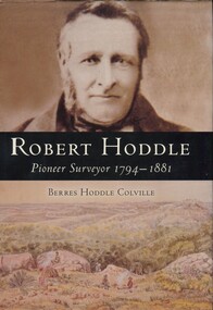
Book, Robert Hoddle: pioneer surveyor 1794-1881, 2004
(Ms) Berres Hoddle Colville is a local Surrey Hills resident and is a descendant of Robert Hoddle. Robert Hoddle was the first Surveyor General of Victoria. He arrived in Australia in 1823 and was one of the very earliest surveyors to explore, measure and map large areas of this vast, varied and difficult countryside, in a burgeoning era of pastoral settlement. 1837 saw him appointed Surveyor in Charge of the Port Phillip District. This book is based firmly on substantial extracts from Hoddle's own diary and other writings. Includes black and white sketches, maps and colour pages.Robert Hoddle was the first Surveyor General of Victoria. He arrived in Australia in 1823 and was one of the very earliest surveyors to explore, measure and map large areas of this vast, varied and difficult countryside, in a burgeoning era of pastoral settlement. 1837 saw him appointed Surveyor in Charge of the Port Phillip District. This book is based firmly on substantial extracts from Hoddle's own diary and other writings. Includes black and white sketches, maps and colour pages.Front endpaper: SURREY HILLS HISTORICAL / SOCIETY / PURCHASED FROM / THE AUTHOR ON THE OCCASION / OF HER TALK ON ROBERT HODDLE / TO THIS SOCIETY ON 17-10-[20]05 Title page: signed by the author: Berres Hoddle Colville / 17 October 2005 /(mr) robert hoddle, surveyors, (ms) berres hoddle colville -
 University of Melbourne, Burnley Campus Archives
Photograph - Black and white print, 81, 1947
Tree labelled, "The Corroboree Tree. This tree has been preserved because beneath it the aboriginal inhabitants held corrobories, which were witnessed by white men in the early days of settlement of this state."corroboree tree, aboriginal inhabitants, e. m. gibson collection -
 Port Fairy Historical Society Museum and Archives
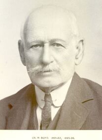
Photograph, Cr William Boyd Shire of Belfast President 1891-92 95-96
Councillor William Boyd was the son of Alexander Boyd who emigrated from Scotland and purchased the property known as Tarrone station in 1884. William managed the station grazing cattle and sheep. The area was later to become part of the Soldier Settlement land after the Second World War.Black and white portraitbelfast, president, government, portrait, shire, council, municipal, local-government, tarrone -
 Bacchus Marsh & District Historical Society
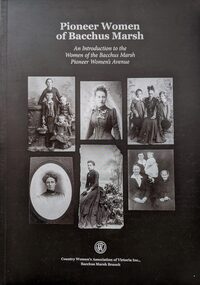
Book, Pioneer Women of Bacchus Marsh: An Introduction to the Women of Bacchus Marsh Pioneer Women's Avenue
This book explores the lives of 274 pioneer women of Bacchus Marsh and district. In this work the pioneer period is defined as women who were either born in the Bacchus Marsh area before 1869 or arrived there prior to 1869. The women's stories in the book are derived from the list of women pioneers of the district compiled in 1936 to commemorate the centenary of European settlement in Bacchus Marsh.Importantly this 2015 publication identifies a number of First Nations women known to have lived in the district prior to 1869 and acknowledges the fact that many thousands of women have lived in the district prior to the European colonial era. Citation: Pioneer Women of Bacchus Marsh: An Introduction to the Women of the Bacchus Marsh Pioneer Women's Avenue. [Written and compiled by the Country Women's Association Branch, Bacchus Marsh]. Published by Country Women's Association of Victoria Inc., Bacchus Marsh Branch, 2015.An A4 sized printed book published in paperback edition. 228 pages, with black white photographs and portraits and illustrations. Includes a\subject and name indexes. BMDHS Location: AR/SU4non-fictionThis book explores the lives of 274 pioneer women of Bacchus Marsh and district. In this work the pioneer period is defined as women who were either born in the Bacchus Marsh area before 1869 or arrived there prior to 1869. The women's stories in the book are derived from the list of women pioneers of the district compiled in 1936 to commemorate the centenary of European settlement in Bacchus Marsh.Importantly this 2015 publication identifies a number of First Nations women known to have lived in the district prior to 1869 and acknowledges the fact that many thousands of women have lived in the district prior to the European colonial era. Citation: Pioneer Women of Bacchus Marsh: An Introduction to the Women of the Bacchus Marsh Pioneer Women's Avenue. [Written and compiled by the Country Women's Association Branch, Bacchus Marsh]. Published by Country Women's Association of Victoria Inc., Bacchus Marsh Branch, 2015.bacchus marsh vic. history, pioneers biographies, women pioneers bacchus marsh -
 Mont De Lancey
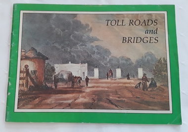
Booklet, Department of Main Roads, Toll Roads and Bridges, 1981
A brief history of tolls used throughout history, dating back around 1950 B.C. Early English and USA use is mentioned. Road and bridge tolls in Australia were collected for construction and maintenance of particular roads and bridges similar to their use in England. The clear photographs show the development in the this country up to 1981 when the brochure was published.A small slim rectangular paperback brochure with a lithograph of the "New Toll Gate" on Parramatta Road, published in J.G. Austin's Sydney Views. Green and white edging surrounds the picture with the title Toll Roads and Bridges printed in black lettering at the top right of the cover. On the back is a photograph of Toll cabins at the northern end of the Sydney Harbour Bridge showing automatic and manual toll booths with the symbol for NAASRA and National Association of Australian State Road Authorities printed in black and white at the bottom. Pp. 20. There are many photographs inside.non-fictionA brief history of tolls used throughout history, dating back around 1950 B.C. Early English and USA use is mentioned. Road and bridge tolls in Australia were collected for construction and maintenance of particular roads and bridges similar to their use in England. The clear photographs show the development in the this country up to 1981 when the brochure was published.road tolls, roads, bridges, history of tolls -
 Harcourt Valley Heritage & Tourist Centre
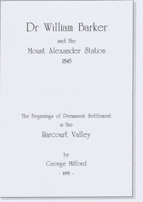
book, Dr. William Barker and the beginnings of permanent settlement in the Harcourt Valley 1845, 1995
... anniversary of permanent settlement celebrated in 1995 Published ...Researched and Published for the 150th anniversary of permanent settlement celebrated in 1995Published to coincide with the 150th anniversary of the first permanent white settlement in the Harcourt valley.which was the occasion for community celebrations and of publication of a short history of squatting era pioneer Dr William Barker FRCS. Booklet of 8 pages in a hard cover“Dr Willam Barker and the beginnings of permanent settlement in the Harcourt Valley 1845” -
 Wodonga & District Historical Society Inc
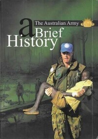
Book - The Australian Army - A Brief History, Austin, Brigadier M and Lever, Major Geoff, 2001
A revised short history of the Australian Army beginning with Aboriginal resistance to settlement; through an examination of the service of colonial forces in the Sudan and Boer Wars; both World Wars, Korea, Vietnam and Afghanistan. It contains a detailed section explaining the history and traditions of the Australian Army including patches, badges, the slouch hat and the Rising Sun badge.A bound volume of 96 pages featuring an image of an Australian soldier carrying an injured child on the cover. This publication includes 11 maps in colour as well as black and white and colour illustrations.A revised short history of the Australian Army beginning with Aboriginal resistance to settlement; through an examination of the service of colonial forces in the Sudan and Boer Wars; both World Wars, Korea, Vietnam and Afghanistan. It contains a detailed section explaining the history and traditions of the Australian Army including patches, badges, the slouch hat and the Rising Sun badge.australian military, military history -
 Wodonga & District Historical Society Inc
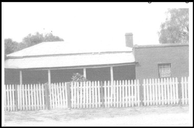
Photograph - Old Barnawartha Homestead
Henry Richardson came from England in 1852 and this was his home from 1871 to 1888. His son Henry, better known as Harry, managed the property from 1888 until his death in 1926. The property was sold in 1932 and has been known as Old Barnawartha for over 140 years. The homestead exhibited no particular style, it looked like a Cornish Miner’s cottage, and appeared as if pieces were added on as the need arose. The property is well known for topping both sheep and cattle sales at Newmarket.This item is significant because it depicts the home of an early Wodonga District pioneerA black and white image of an old homestead. There is a white picket fence across the front of the building.old barnawartha, early settlement, wodonga and district -
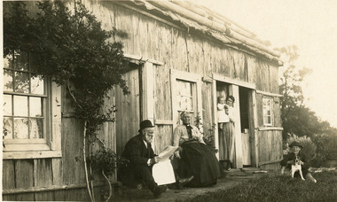 Lakes Entrance Historical Society
Postcard - Northrope House, Bulmer H D, 1920
Black and white postcard showing slab bark house belonging to Northrope family. Photograph shows Mr Northrope sitting in front reading a newspaper, Mrs Northrope sitting in a chair, young mother and baby in doorway, boy with dog on grass. Climbing rose over window. Bark roofing overhanging wall held down with logs. All glass windows. Lake Bunga VictoriaThe Homestead Lake Bunga Vicgenealogy, historic site, houses, settlement -
Port Melbourne Historical & Preservation Society
Programme, A Holborn Rover, The Port Melbourne Settlement Presents: Broadcast 1938 a musical revue in two parts, 1938
"The Port Melbourne Settlement Presents: Broadcast 1938 a musical revue in two parts." 3 page black and white copy of a program for a musical revue put on by the "Port Melbourne Settlement" which had begun in 1932 to assist under privileged boys. Page one has the title; page 2 a short history of the services provided; page 3 a program of "broadcast 1938"arts and entertainment - community arts, charities and appeals, societies clubs unions and other organisations, port melbourne settlement -
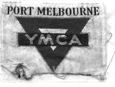 Port Melbourne Historical & Preservation Society
Badge - Port Melbourne YMCA
The YMCA occupied the former Scout Settlement quarters at 315 Nott Street in (1950s/60s/70s?)Small cloth badge, red, blue, gold and white, 'Port Melbourne YMCA'ymca, societies clubs unions and other organisations -
Port Melbourne Historical & Preservation Society
Book - Reference, Grids and Greenery. The Character of Inner Melbourne, 1987
"Grids and Greenery. The Character of Inner Melbourne" A largely pictorial account of how inner Melbourne's public spaces have developed from early settlement to the 1980s. 71 pages, white cover with grey grid and bright colours on the frontbuilt environment - civic, natural environment, parks and gardens -
Tatura Irrigation & Wartime Camps Museum
Book - Folder, Eschol Irrigation Settlement 1893 Book 1, 1985
Eschol Irrigation Settlement Prospectus, 1893. Original document photocopied by David Carrol, Tatura Research Station. A scheme for more agricultural settlements from irrigation areas.Black A5 folder with white printed label on front. Title on spine. Contains 20 plastic sleeves.inside cover: white label: Donor Tom Flanagan, Hogan Street Tatura 9.8.1985irrigation, document, eschol irrigation, david carrol, tatura research station -
Tatura Irrigation & Wartime Camps Museum
Book - Folder, Eschol Irrigation Settlement 1893 Book 2, 1985
Eschol Irrigation Settlement information including maps, business directory 1893. Book 2Black A5 plastic folder, white label, blue writing on front. 20 plastic sleeves.inside front cover: Donor Tom Flanagan Tatura 9.8.1985irrigation, documents, newspapers, eschol irrigation -
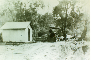 Lakes Entrance Historical Society
Photograph - Tramline, 1930c
... Site Settlement Black and white photograph of the tramline used ...Tramline used to transport red granite from the quarry at Mississippi Creek to the landing at the head of the North Arm, Lakes Entrance, Victoria showing the converted Fordson tractor used to haul the trucks of stone on the 3 foot 6 inch line 105cm approximately 1920 to 1939. Lakes Entrance VictoriaBlack and white photograph of the tramline used to transport red granite from the quarry at Mississippi Creek to the landing at the head of the North Arm, Lakes Entrance, Victoria showing the converted Fordson tractor used to haul the trucks of stone on the 3 foot 6 inch line 105cm approximately 1920 to 1939. Lakes Entrance Victoriatransport, historic site, settlement -
 Lakes Entrance Historical Society
Photograph - Lake Tyers Aboriginal Settlement, 1940
Unidentified children, photograph taken at Lake Tyers Aboriginal Station.Small format black and white photograph four small children, one in pram, church building in background. Lakes Tyers Victoriaaboriginals, lake tyers -
Broadmeadows Historical Society & Museum
Book - Annual Report, Alex Simic et al, City of Broadmeadows Annual Report 1993, 1993/4
... of Broadmeadows from the start of white settlement to the 1908s. 28pp ...History of Broadmeadows from the start of white settlement to the 1908s.28pp, Paper Stapled with Card CoverHistory of Broadmeadows from the start of white settlement to the 1908s.broadmeadows, annual report, 1993 -
 Sunbury Family History and Heritage Society Inc.
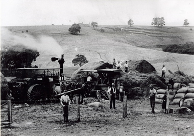
Photograph, The Nook
The photograph was taken in The Nook. Terence O'Brien rented the land from Goonawarra from the 1890s to 1905 where he grew cereal crops. The terraces on the hillside were built to grow vines when the property was one of the first vineyards in the area. The men in the image are from L-R: Mr. Heath in the white cutter owned the chaff cutter, John Leyden with hand on fence, Michael Dillon, Terence O'Brien and Phil Ratile are on top of the haystack, Andy Burke standing with hand on hip.The growing and harvesting of cereal crops was an important agricultural industry in the early days of Sunbury's settlement by both the Indigenous People and Europeans.A non-digital photograph black and white photograph of eleven men gathering hay with the aid of a steam traction engine in a wide open valley. A hillside in the distance has been terraced and there is a house on the hill in the distance.the nook, terence o'brien, andy burke, mr. heath, michael dillon, philratile, goonawarra, vineyards -
 Sunbury Family History and Heritage Society Inc.
Photograph, Jubilee train 1951, c 1951
The 'N' Class steam locomotives were built by Victorian Railways to be used on branch lines throughout the state's regional areas. A total of 73 of these locomotives were built between 1925 and 1951. The locomotive in the photograph carried the Jubilee Train that travelled throughout Victoria in 1951 and had a display featuring 125 years of European settlement in Victoria. When the photograph was taken the train was steaming into Sunbury where it stopped to allow people to board it and look at the exhibitionSunbury Station was an important stop for steam locomotives travelling on the Bendigo line. Even after diesel engines were used to pull the trains in the 1950s, steam locomotives were also used until the early 1990s.A non-digital black and white photograph of a 'N'class steam engine on railway tracks.steam locomotives, jubilee train, sunbury -
 Lakes Entrance Historical Society
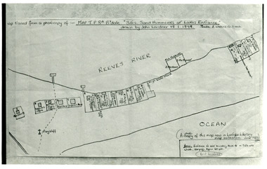
Photograph - New Works Plan, 1898
... Settlement Plan Black and white photograph showing sketch map of 1898 ...Map traced from a photocopy of :- Map TP8A Bairnsdale. 'Site. Sand Hummocks of Lakes Entrance'. Drawn by John Lardner 18 January 1898. Scale two chains to one inch. ( A photocopy of this map in Latrobe Library map collection, June 1983)Black and white photograph showing sketch map of 1898 by John Lardner Plan of Sites - sand hummocks. Drawing shows sites of buildings at entrance along Cunninghame Arm shoreline at Lakes Entrance, Victoria.land settlement, plan -
 Lakes Entrance Historical Society
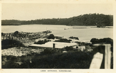
Postcard - New Works, Bulmer H D, 1910c
Also second copy same sizeBlack and white postcard showing view of Works buildings and north end of eastern pier. Cunninghame Arm and tip of Bullock Island and groyne work on right. Reeves channel and tip of Rigby Island on left. Mt Barkly and Kalimna Hills in background. Photo taken from top of dune. Roof of Carstairs boarding house centre foreground. Lakes Entrance VictoriaLakes Entrance, Cunninghamewaterways, settlement, historic buildings -
 Lakes Entrance Historical Society
Photograph - Carpentertown, Silver Reflections Studio, 1924c
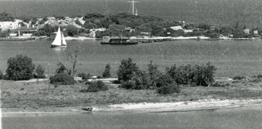
... Waterways Islands Settlement Black and white photograph ...Black and white photograph showing view of New Works. Village on dunes at entrance to Gippsland Lakes from ocean - Bass Strait. View shows SS Gippsland at New Works wharf, Cunninghame Arm, part of Bullock Island and mouth of North Arm, post and rail fence along roadway down Jemmys Point. Lakes Entrance Victoriawaterways, islands, settlement -
 Lakes Entrance Historical Society
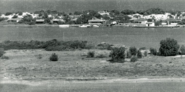
Photograph - Carpentertown, 1920c
Copied from copy in J Whadcoat collectionBlack and white photograph showing P W D cottage on left and other Works buildings on dune at the entrance to Gippsland Lakes from the ocean - Bass Strait. View shows flagstaff on top of dune and flagstaff jetty in lake - Cunninghame Arm. Small sailing boat on left and other small craft on shoreline. Section of Bullock Island with vegetation, one telegraph pole and one dead tree on island. Shoreline of North arm in foreground. Lakes Entrance Victoriajetties, waterways, settlement, historic site, boats and boating -
 Lakes Entrance Historical Society
Photograph - Carpentertown, 1920c
... Islands Settlement Black and white photograph showing view ...Copied from a copy in possession of J WhadcoatBlack and white photograph showing view of seven cottages on dunes. View of several boats at jetties and on slipway, white shed on New Works wharf, Cunninghame Arm in front of cottages, part of Bullock Island showing some vegetation and one telegraph pole. Lakes Entrance Victoriawaterways, islands, settlement -
 Lakes Entrance Historical Society
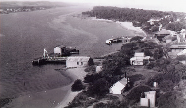
Photograph - New Works
Black and white photograph showing aerial view of Works buildings and cottages near man-made entrance to Gippsland Lakes Victoria boats and boating, topography, settlement, historic buildings -
 Warrnambool and District Historical Society Inc.
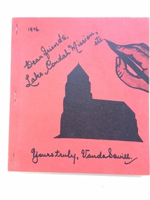
Book, Lake Condah Mission etc
This is a book by Vanda Savill giving information on the Lake Condah Aboriginal settlement, its inhabitants and its immediate neighbouring settlers. Lake Condah Mission settlement in Western Victoria was established in 1867. Vanda Savill (1913-2005) with her husband ran a dairy farm and the Bower Birds Nest Museum and History Centre at Heywood. She was passionate about keeping alive the local people’s personal histories and for 20 years, in the 1970s, 80s and 90s, she wrote and published many books on the areas around Heywood. This book is of interest as it gives information on the history of Lake Condah Aboriginal Settlement and the neighbouring settlers in this area. It is also of interest because of the author’s warm and conversational writing style. This is a soft cover book of 164 pages. It has a red cover with black and white images on the front cover of a church and a hand holding a pen. It has been stapled. There are many black and white sketches, illustrations and photographs in the book. The text has been handwritten in cursive script and then printed. lake condah aboriginal settlement, history of western victoria, vanda savill, warrnambool, history -
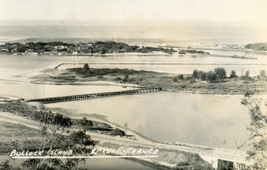 Lakes Entrance Historical Society
Postcard - Bullock Island, Bulmer H D, 1945
Black and white postcard of Bullock Island, Lakes Entrance, showing an extensive rock groyne to the south of the island, into which dredged sand and spoil is to be placed in order to extend the island's area. North Arm bridge, Bullock Island footbridge, New Works settlement and Entrance channel also in image. Lakes Entrance VictoriaBullock Island, Lakes Entranceboats and boating, fishing industry, islands