Showing 10199 items
matching main road
-
 Eltham District Historical Society Inc
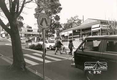
Photograph, Arthur Street, Eltham, 4 Aug 1992, 4/8/92
... the corner with Main Road. The old Woolworths, now the present day... Arthur Street from the corner with Main Road. The old Woolworths ...Black and white photograph looking up Arthur Street from the corner with Main Road. The old Woolworths, now the present day site of Coles is on the right hand sidearthur street, eltham -
 National Vietnam Veterans Museum (NVVM)
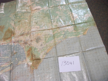
Map, Intelligence Map
... main roads, towns and city locations current or ruined. River... topographical map of part of Vietnam featuring main roads, towns ...Vinyl coated topographical map of part of Vietnam featuring main roads, towns and city locations current or ruined. River locations etc. Names all in Vietnamese language.map, vietnam -
 Lakes Entrance Regional Historical Society (operating as Lakes Entrance History Centre & Museum)
Photograph, 1990 c
... of main road from Bruthen to Mossiface Victoria.... Situated on eastern side of main road from Bruthen to Mossiface ...Black and white photograph of large maize crib possibly last one still remaining in district. Situated on eastern side of main road from Bruthen to Mossiface Victoriawaterways -
 Eltham District Historical Society Inc
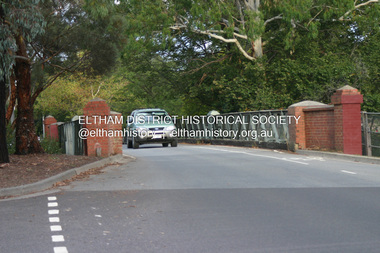
Photograph - Digital Photograph, Alan King, The Diamond Creek Bridge, 30 March 2008
... main hurstbridge road...Old Bridge on Main Hurstbridge road in Diamond Creek... melbourne Old Bridge on Main Hurstbridge road in Diamond Creek ...Old Bridge on Main Hurstbridge road in Diamond Creek township crossing the Diamond Creek. The bridge opened in April 1898. Evelyn Observer, and South and East Bourke Record (Vic. : 1882 - 1902), Friday 22 April 1898, page 2 "Diamond Creek Bridge. The official opening of this bridge took place yesterday (Thursday) in the presence of a large gathering of people. The bridge-a substantial iron structure, costing .~r 2oo-was profusely decorated with "flags of all nations" for the occasion. In the absence of the Minister' of Public Works-who was unavoidably prevented from attending-the opening ceremony was neatly performed by President Lugton, of the Heidelberg Shire, in a few wellchosen words, after which an adjournment was made to the Literary Institute, where some sixty gentlemen were entertained at luncheon, followed by speeches, songs, and recitations. It was a red letter day for the Creek, and everything passed off with becoming eclat." Published: Nillumbik Now and Then / Marguerite Marshall 2008; photographs Alan King with Marguerite Marshall.; p7This collection of almost 130 photos about places and people within the Shire of Nillumbik, an urban and rural municipality in Melbourne's north, contributes to an understanding of the history of the Shire. Published in 2008 immediately prior to the Black Saturday bushfires of February 7, 2009, it documents sites that were impacted, and in some cases destroyed by the fires. It includes photographs taken especially for the publication, creating a unique time capsule representing the Shire in the early 21st century. It remains the most recent comprehenesive publication devoted to the Shire's history connecting local residents to the past. nillumbik now and then (marshall-king) collection, diamond creek, diamond creek bridge, main hurstbridge road -
 Mt Dandenong & District Historical Society Inc.
Photograph
... Jim Keogh's shop on the north west corner of Falls and Main... Community Hall 42 Falls Road Mt Dandenong yarra-valley ...Jim Keogh owned Lot 7 of the Village Settlement. When the new CRB road went through c1920 his block was cut through leaving a small triangle of land on the high side of the CRB road. He built a shop on this piece of land. The store burned down 31/12/1939. The woman on the step in this photo is Win Woodcock.Sepia image of a woman standing in front of a wooden store. Handwritten inscription on reverse by John Lundy-ClarkeJim Keogh's shop on the north west corner of Falls and Main Roads. Opposite diagonally from St Michael's Church of England. photo Nov 1926.jim keogh, keogh, store, shop, crb road, win woodcock -
Whitehorse Historical Society Inc.
Article, The Best Of Nunawading, 14/06/2000 12:00:00 AM
... Road which was officially declared a main road in 1933. Also... a main road in 1933. Article in Whitehorse Gazette talking about ...Article in Whitehorse Gazette talking about busy Springvale Road which was officially declared a main road in 1933.Article in Whitehorse Gazette talking about busy Springvale Road which was officially declared a main road in 1933. Also Wobbies World closing down, in the column 'Streets Where You Live'.Article in Whitehorse Gazette talking about busy Springvale Road which was officially declared a main road in 1933.roads and streets, wobbies world, springvale road, nunawading, nunawading -
Whitehorse Historical Society Inc.
Map, M.M.B.W - Schwerkolt Cottage, 30/04/1968
... Extract from M.M.B.W. map No 79 showing proposed main road... showing proposed main road, open space, residential zones C & D ...Extract from M.M.B.W. map No 79 showing proposed main road, open space, residential zones C & D and location of Schwerkolt Cottage. Approved 40/04/1968. 2 copiesschwerkolt cottage, melbourne and metropolitan board of works, eastern freeway -
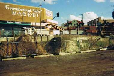 Greensborough Historical Society
Photograph - Digital image, Para Road Greensborough from the Station, 1975_
... Photograph of the intersection of Para Road and Main Street... of Para Road and Main Street Greensborough circa 1975. Shows ...Photograph of the intersection of Para Road and Main Street Greensborough circa 1975. Shows the Greensborough Valley Market on the corner and Greensborough Hotel in background. Taken from the Station, the train line can be seen in the foreground.Digital copy of colour photograph.greensborough valley market, greensborough station, para road, main street greensborough -
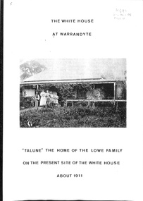 Ringwood and District Historical Society
Book, The White House At Warrandyte, 1988
... and Cemetery Road circa 1850s, and later had a frontage to the Main... and Cemetery Road circa 1850s, and later had a frontage to the Main ...The first known residents were Mr and Mrs Walter Pretty and their family who moved there in 1856. Mr William Collins took out a miner's right in 1886 and Mr and Mrs Frank Lowe bought the freehold when the site was auctioned in 1930.History of families associated with the property originally leased on a miner's right near the corner of Yarra Street and Cemetery Road circa 1850s, and later had a frontage to the Main Road with access from to Taroona Avenue. -
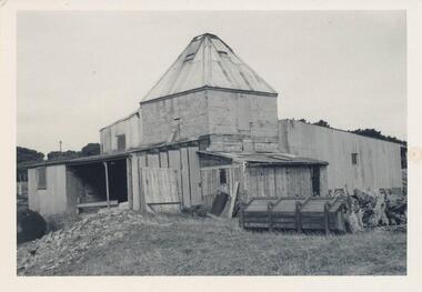 Phillip Island and District Historical Society Inc.
Photograph, 1960's
... Black & White Photograph. Chicory Kiln. Cowes, Main Road... Archibald Black & White Photograph. Chicory Kiln. Cowes, Main Road ...Donated by N. M. & J. D. Archibald. April 1973Black & White Photograph. Chicory Kiln. Cowes, Main Road - Mr. G. Stoppa. Cement blocks with Iron, Wood & Fibro. Built late 1940's or 50's. Chicory Kiln Album.local history, photography, photographs, agriculture buildings, historic, chicory kiln, cowes, phillip island, g stoppa, n & j archibald -
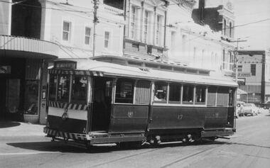 Ballarat Tramway Museum
Photograph - Digital image, c1971
... , turning from Bridge St into Main Road outbound for Mt Pleasant... and white print of tram 13, turning from Bridge St into Main Road ...Yields information about Ballarat streetscape and its trams in the closing days of the SEC tramway system.Digital image from a black and white print of tram 13, turning from Bridge St into Main Road outbound for Mt Pleasant with the various buildings on the southside in the background. Photo by Marc Dahlstrom c1971. On rear is the Marc Dahlstrom stamp.trams, tramways, bridge st, stones corner, tram 13 -
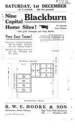 Whitehorse Historical Society Inc.
Document, Auction Notice
... Auctions|Molleton Street, Blackburn|Baldwin Road, Blackburn... Road and Main Street, Blackburn... notice for 9 home sites in Molleton Street, Baldwin Road and Main ...Auction notice for 9 home sitesAuction notice for 9 home sites in Molleton Street, Baldwin Road and Main Street, BlackburnAuction notice for 9 home sitesauction notice for molleton street, baldwin road, blackburn -
Glenelg Shire Council Cultural Collection
Photograph - Photograph - Main Breakwater construction, Portland, 29/08/1952
... Black & white photo of main breakwater access road, looking...Front: MAIN BREAKWATER ACCESS ROAD 29/8/52 - black print... of main breakwater access road, looking up slope. Lady Bay on left ...Port of Portland Authority ArchivesFront: MAIN BREAKWATER ACCESS ROAD 29/8/52 - black print Back: Purple PHT Stamp - print 4/7 Neg No. P1 Date taken 29.8.52 Subjectport of portland archives, main breakwater, construction, lady bay, portland, harbour -
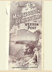 Ringwood and District Historical Society
Memorabilia, Tourist Map of Mornington Peninsula and Western Port - 1929
... Multi-fold pictorial map of towns, railways and main roads... of towns, railways and main roads east of Port Phillip Bay from ...Multi-fold pictorial map of towns, railways and main roads east of Port Phillip Bay from Melbourne to Yarra Junction and south to Phillip Island and Wonthaggi, backed by details of main features and points of interest.Photo-Lithographed by Department of Lands and Survey, Melbourne, 2.8.1929. -
Whitehorse Historical Society Inc.
Map, Facilities provided for you, 1970
... Map of the City of Nunawading showing main roads... and reserves Map of the City of Nunawading showing main roads ...Map of the City of Nunawading showing main roads and reserves with numbers indicating location of Halls, Infant Welfare Centres, Elderly Citizens Clubrooms and other major Council facilities. Route of proposes Healesville Freeway marked.Map of the City of Nunawading showing main roads and reserves with numbers indicating location of Halls, Infant Welfare Centres, Elderly Citizens Clubrooms and other major Council facilities. Route of proposes Healesville Freeway marked.Map of the City of Nunawading showing main roads and reserves with numbers indicating location of Halls, Infant Welfare Centres, Elderly Citizens Clubrooms and other major Council facilities. Route of proposes Healesville Freeway marked.city of nunawading, maps, maternal and child health centres, senior citizens centres, healesville freeway, parks and reserves -
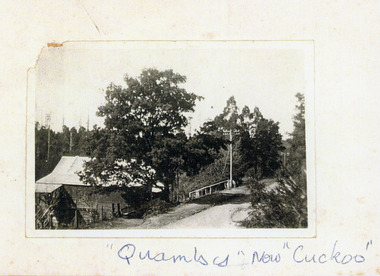 Mt Dandenong & District Historical Society Inc.
Photograph, Quamby now 'Cuckoo', c1930
... Quamby Café viewed from high side of Main Road looking... of Main Road looking towards Sassafras c1930. Power lines visible ...Quamby Café viewed from high side of Main Road looking towards Sassafras c1930. Power lines visible and road unmade. Quamby Café built by the Dorey family in 1914. Now the Cuckoo Restaurant.On front - Quamby now "Cuckoo"quamby, quamby cafe, cuckoo, olinda, iris dorey, dorey -
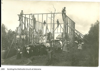 Mt Dandenong & District Historical Society Inc.
Photograph, Building the Methodist Church at Kalorama, 1909
... Church on the Main Road (Ridge Road) at Kalorama. Eight workmen... Church on the Main Road (Ridge Road) at Kalorama. Eight workmen ...The Methodist Church was built in 1909 by volunteer labour. Mainly through the efforts of the daughters of Eliza Hand and their families - the Jeeves, Walkers and Badenhops. (Lundy-Clarke manuscript)Local residents working to erect the frame of the Methodist Church on the Main Road (Ridge Road) at Kalorama. Eight workmen are on the frame with fifteen well dressed residents standing in front. 1909. Image received as a digital jpeg.Printed on front of photo: 1909 Building the Methodist Church at Kalorama church, kalorama methodist church, methodist church -
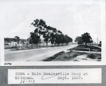 Whitehorse Historical Society Inc.
Photograph, Whitehorse Road, Healesville 1937, 1/09/1937 12:00:00 AM
... Black and white photograph of main Healesville Road... and white photograph of main Healesville Road (Whitehorse road ...Black and white photograph of main Healesville Road (Whitehorse road) in September 1937.healesville road, mitcham, whitehorse road -
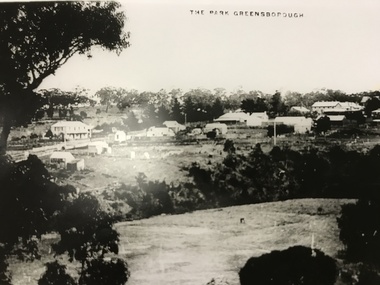 Greensborough Historical Society
Photograph, The Park Greensborough, 1900c
... side of Main Road, the Farmers' Arms hotel, the Rechabite Hall..., sparse housing on north side of Main Road, the Farmers' Arms ...View of Greensborough Park from Partington's Hill, showing sporting ground, Plenty River, Marble Hall, sparse housing on north side of Main Road, the Farmers' Arms hotel, the Rechabite Hall and Main Road bridge over the the railway line. Marble Hall is the double-storied building on the corner of Main Road.Part of a collection of 5 enlarged photographs dating from the early 1900s.Black and white enlargement of photographgreensborough park, main street greensborough, rechabite hall, farmers' arms hotel, marble hall, greensborough railway -
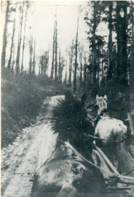 Mt Dandenong & District Historical Society Inc.
Photograph, View From Seat of Jeeves Coach, c1921
... (Main) Road between Wombat Road and Falls Road. c1921... Community Hall 42 Falls Road Mt Dandenong yarra-valley ...View the driver would have from horse drawn coach. CRB (Main) Road between Wombat Road and Falls Road. c1921. This photograph has a detailed inscription on the back handwritten by John Lundy-Clarke in 1974.View from seat of Jeeves Coach over horses while being driven along the new CRB road between Wombat Road and Falls Rd 1921.wombat road, falls road, crb road, jeeves coach, horse -
Glenelg Shire Council Cultural Collection
Photograph - Photograph - Main Breakwater construction, Portland, 04/12/1952
... Black & white photo of construction of main breakwater...Front: MAIN BREAKWATER ACCESS ROAD 4.12.52 TRUST WORKS... of main breakwater access road. Harbour Trust houses back left ...Port of Portland Authority ArchivesFront: MAIN BREAKWATER ACCESS ROAD 4.12.52 TRUST WORKS HOUSES IN BACKGROUND - Blackprint. Back: Square purple stamp - Print No 4/9 Neg No 81 Date Taken 4.12.52 Subjectport of portland archives, main breakwater, construction, portland, harbour, harbour development -
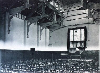 City of Ballarat Libraries
Photograph - Card Box Photographs, Interior of the Ballarat Town & City Mission Hall circa 1930
... The hall was located on Main Road.... Ballarat East goldfields The hall was located on Main Road ...The hall was located on Main Road.ballarat town & city mission, building, public -
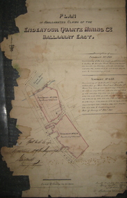 Federation University Historical Collection
Plan, Plan of the Endeavour Quartz Mining Co., Ballarat East, 1874, 04/01/1874
... were along Main Road and Eureka Street in close proximity.... and tenements 634 and 546. The tenements were along Main Road and Eureka ...Hand drawn and coloured paper plan relating to the Endeavour Quartz Mining Co. and tenements 634 and 546. The tenements were along Main Road and Eureka Street in close proximity to the Barkly Street and the Ballarat East Town Hall.ballarat east, endeavour quartz mining co, mining, plan, cgt -
 Greensborough Historical Society
Postcards, Yarra Plenty Regional Library, Eltham District Historical Society postcards, 1900s
... 1. Watson's Hotel, cnr. Pitt Street and Main Road Eltham c... and Main Road Eltham c. 1902. 2. Main Road Hurstbridge. 3. Railway ...1. Watson's Hotel, cnr. Pitt Street and Main Road Eltham c. 1902. 2. Main Road Hurstbridge. 3. Railway workers celebrate the first steam train to Hurstbridge 1912Three black & white postcardswatson's hotel, eltham, hurstbridge, hurstbridge train line, eltham district historical society -
 Greensborough Historical Society
Photograph - Digital image, Edward Henry Blackbourn, 1920c
... Edward Henry Blackbourn, taken at 155 Main Road Lower... at 155 Main Road Lower Plenty with Main Road in background ...Edward Henry Blackbourn, taken at 155 Main Road Lower Plenty with Main Road in background. Photographs from the collection of Peter Blackbourn, a descendant of the Chapman Stock family. Annotations to photos by Peter Blackbourn.Digital copy of black and white photograph.peter blackbourn, edward henry blackbourn -
 Greensborough Historical Society
Photograph - Digital image, Unknown Local View Possibly Rosanna Road from Heidelberg or Grimshaw Street to Greensborough, 1925c
... Possibly view of Main Road to Greensborough.... Plenty Lower Plenty melbourne Possibly view of Main Road ...Possibly view of Main Road to Greensborough.Digital copy of black and white photograph. -
 Orbost & District Historical Society
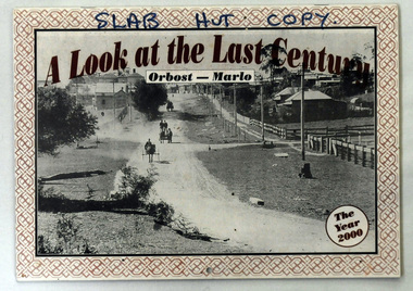
calendar, A Look at the Last Century, 2000
... " Orbost-Marlo. On the front cover is a photograph "Main Road... Century" Orbost-Marlo. On the front cover is a photograph "Main ...The calendar was produced as a souvenir of the Orbost/Marlo area for sale in the Orbost Visitor Information Centre, The Slab Hut.This is a photographic souvenir of Orbost and is a good research tool.A calendar for the year 2000. It contains b/w photographs of the Orbost district and is titled, "A Look at the Last Century" Orbost-Marlo. On the front cover is a photograph "Main Road into Town 1917". It shows "Hoffman's paddock and Herbert's Bulk Store and Bakery.SLAB HUT COPY at the top in black.history-orbost photographs -
 Ringwood and District Historical Society
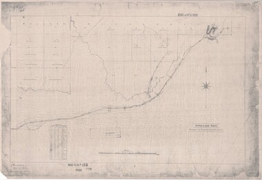
Map, Road Plan 108 - Gipps-land Road, Parishes of Bulleen and Warrandyte (Ringwood, Victoria) - 1855
... Surveyor's map of the part of the main road from Melbourne... Road Ringwood North melbourne Submitted to the Surveyor General ...Surveyor's map of the part of the main road from Melbourne to Gippsland following "Barker's Track" south of Mullum Mullum or Deep Creek. Map references include Roman numerals marking distances measured in Links between trees at turns in the road.Submitted to the Surveyor General (Signed) July 2nd 1855. -
 Eltham District Historical Society Inc
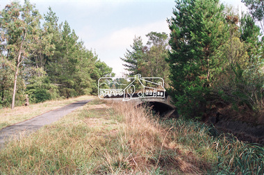
Negative - Photograph, Maroondah Aqueduct Trail near The Esplanade, Research, 1991
... towards The Esplanade near Main Road, Research, 1991. Just after... towards The Esplanade near Main Road, Research, 1991. Just after ...Looking northwest along the Maroondah Aqueduct Trail towards The Esplanade near Main Road, Research, 1991. Just after first bend from Main Road. To the left is present day (2022) Mickey's FitnessRoll of 35mm colour negative film, 9 strips Colour print 10 x 15 cmFuji HG 200 CA-1bridge, ingrams road, maroondah aqueduct, maroondah aqueduct trail, research (vic.), the esplanade -
 Eltham District Historical Society Inc
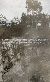
Photograph, Flood at Eltham, c.1924
... Probably the 1924 flood which damaged the Main Road Bridge... melbourne Probably the 1924 flood which damaged the Main Road Bridge ...Probably the 1924 flood which damaged the Main Road Bridge Pages from a scrapbook belonging to Heather Jenkins (nee Sargeant) who lived as a child in the Police Residence at 728 Main Road, Eltham in the 1920s.Heather Sargeant was the daughter of Constable W.C. Sargeant, the local police officer in residence at Eltham, 1922-1927Glued on a brown paper scrapbook page (torn from scrapbook) with 8 black and white/sepia photos of varying sizes, 1 newspaper clipping and one greeting card with printed sketch and handwritten captions in ink. On back of page is 1 black and white photo and a large newspaper clipping.eltham, police residence, heather jenkins (nee sargeant), walter withers, constable w.c. sargeant, floods