Showing 5249 items
matching view road
-
 Ringwood and District Historical Society
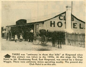
Photograph - Newspaper Clipping, Early View of Club Hotel, Ringwood East
The newspaper clipping caption is incorrect. The Club Hotel featured in the article was located on the north side of Mount Dandenong Road. It was destroyed by fire in 1890 prior to re-opening later on the south side where it operated until sale and demolition in 2020 to make way for a retirement village. (See PDF attached - "SS0067 Vic Collections 3754b - Club Hotel Fire 1890").Early View of Club Hotel, Ringwood East. Weatherboard with iron roof. Single chimney on one end. Picket fence on RHS. Two horse-drawn vehicles standing out front including three adults and two children. Source/date of newspaper unknown. Later newspaper item also attached reporting hotel being destroyed by fire in 1890.Caption: There was 'antimony in them thar hills' at Ringwood when this picture was taken in the 1890s. At that time the Club Hotel in Mt Dandenong Road, East Ringwood was owned by a George Wiggin. There were antimony mines operating nearby. The present-day Club Hotel is on this site. -
 Ringwood and District Historical Society
Newspaper Clipping, New Home Found for History Marker, 5-Jun-07
New home found for historical marker. Newspaper article covering the move of a historical marker of the Borough of Ringwood to the Shire Offices precinct. View of marker in its new/final location.New home found for historical marker. Newspaper article covering the move of an historical marker of the Borough of Ringwood to the Shire Offices precinct. View of marker in its new/final location. +Additional Keywords: Gurr, Peter / Haines, RussBorough of Ringwood -
 Ringwood and District Historical Society
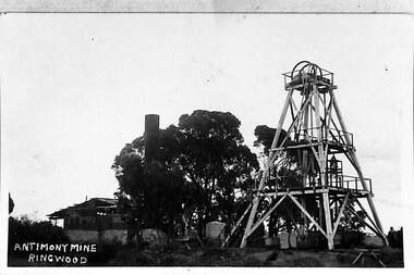
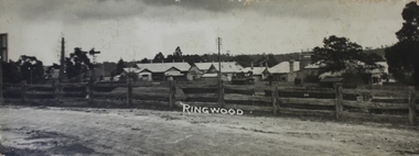
Photograph, View of the Ringwood Antimony Mine, buildings and headframe. C1900, c. 1900
The Antimony mine, set on top of a hill, was originally the centre for Ringwood development. The centre was relocated to the west around Ringwood station when the railway was built.View of the Ringwood Antimony Mine, buildings and headframe. A chimney from a smelter can be seen on the LHS. -
 Ringwood and District Historical Society
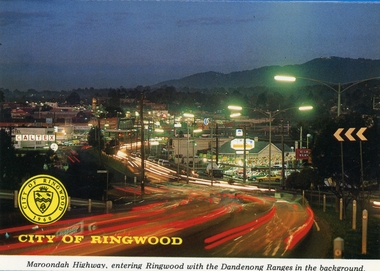
Postcards, Colorscans (Publishing) Pty Ltd, Various postcards of Ringwood in the 1970s, c. 1968
Postcards - pack of 6: 'Ringwood Victoria - tear off postcard folder - 6 views' (two identical folders); 1. Maroondah Highway, entering Ringwood with the Dandenong Ranges in the background (3303_001.jpg); 2. Aerial View of the City of Ringwood (3303_002.jpg); 3. Eastland Regional Shopping Centre at dusk (3303_003.jpg); 4. The Ringwood Memorial Clock Tower (3303_004.jpg); 5. The Civic Centre (3303_005.jpg); 6. The Ringwood Lake (3303_006.jpg) -
Ringwood and District Historical Society
Photographs, Construction Stage of historical Miner's Cottage Museum completed 1983, and panoramic view of partial construction of commercial buildings on former Ringwood Market site, Seymour Street, Ringwood c.1970s. On cardboard
3964/1 15 photographs on cardboard 76cmX51cm depicting construction stages of historical Miner's Cottage Museum completed 1983; 3964/2 4 photographs on cardboard 85.5cmX22.5cm forming panoramic view of partial construction of commercial buildings on former Ringwood Market site, Seymour Street, Ringwood c.1970s -
 Ringwood and District Historical Society
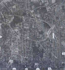
Photograph, Aerial photograph of Heathmont, Victoria - c.1960s, 1975
Aerial view of Heathmont - black and white photograph on chipboard backing. (Protected by slightly damaged plastic cover which could be removed for clearer image.)Department of Crown Lands and Survey Melbourne, Project Run 31A 27-12-1975, Lens 209 1951M ASL. -
 Ringwood and District Historical Society
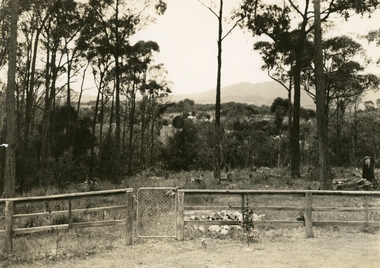
Photograph, Ringwood: Wooden fence and cyclone gate overlooking Mount Dandenong, Kilsyth and Heathmont, taken from Bedford Road, looking South. (undated), circa 1920
... Road Ringwood North melbourne View over Ringwood A photograph ...A photograph of a wooden fence with a cyclone gate overlooking Mount Dandenong, Kilsyth and Heathmont. Taken from Bedford Road, looking south. Donated by Mrs Purser and has printer's marks that suggest that the photograph was printed in a newspaper.View over Ringwood -
Ringwood and District Historical Society
Photograph, View of Ringwood State School builders and plasterers in Nov-1921, Nov-21
Third from the left, top row is Dave Walters. Second from the left is Bert Walters. Both lived in Canterbury Road opposite Heathmont Oval. These plasterers and builders worked on Dame Melba's home later, when the Duke of Gloucester visited Victoria. Dame Melba's home was decorated for the occasion. The plastering was carried out by Walsen (?) Bros. Hardigan, first on the right, back row was a bricklayer who lived in Bedford Road near Illoura Avenue. Acquired c. 2005View of Ringwood State School builders and plasterers in Nov-1921 +Additional Keywords: Walters, David / Walters, Bert / Walsen Bros / Hardigan / Gloucester, Duke of / Melba, Nellie, DameRingwood State School Nov-1921 -
 Ringwood and District Historical Society
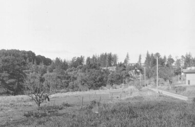
Photograph, View East from Avery Crt North Ringwood. 1981
Written on back of photograph, "24/8/81. View EAST from Avery Crt Nth Ringwood. Wonga Rd in centre below clump of pine trees on skyline. -
 Ringwood and District Historical Society
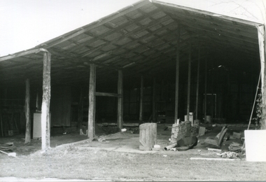
Photograph-B&W, Hill's Dairy, Canterbury Road, Ringwood 1989-The Barn, 6/07/1989
Hill's Dairy, Canterbury Road, Ringwood 1989-The Barn (exterior view). The roof support posts on the left are those in picture 7 (6502-005)The Barn / The roof support posts on the left are those in picture 7 (6502-005) -
 Ringwood and District Historical Society
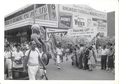
Photograph, View of procession celebrating City of Ringwood 1960 in Maroondah Highway, 1960
... Road Ringwood North melbourne View of procession celebrating ...View of procession celebrating City of Ringwood 1960 in Maroondah Highway corner of New Street outside Ringwood Timber and Trading, including Chinese dragon, musicians and spectators. -
 Ringwood and District Historical Society
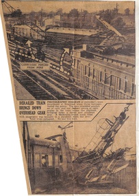
Newspaper - Clippings, Derailment at Ringwood Railway Station, Victoria - 1945
Newspaper reports with view of derailment at Ringwood Railway Station, dog box carriage in foreground, two carriages also derailed appear to be later models. Incident date Friday 22 June, 1945. -
Ringwood and District Historical Society
Photograph, View of War Memorial and Main Street Ringwood, est >1928, c.1928
Construction of the clocktower was completed in 1928.View of War Memorial and Main Street Ringwood, tinted, est >1928. Small print 6.3cm x 8.5cm. -
 Ringwood and District Historical Society
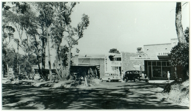
Photograph, Mansourah Picture Framing, Buildings in Canterbury Road Heathmont, February 1960, Feb-60
Peter Le Get found three framed photos of Heathmont view in a Heathmont Opportunity Shop. Previous owners unknown.Framed photograph of buildings in Canterbury Road Heathmont, February 1960.Heathmont, February 1960, Canterbury Road -
 Ringwood and District Historical Society
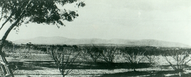
Photograph, Mansourah Picture Framing, Corner of Canterbury Road and Dickasons Road in 1926, 1926
Peter Le Get found three framed photos of Heathmont view in a Heathmont Opportunity Shop. Previous owners unknown.Framed photograph of Mullers Orchard, Heathmont, Taken from the corner of Canterbury Road and Dickasons Road - - looking east, 1926.Mullers Orchard, Heathmont. -
 Ringwood and District Historical Society
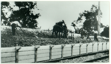
Photograph, Mansourah Picture Framing, Building Heathmont Railway Station Platform by Wieland Brothers 1926, 1926
Peter Le Get found three framed photos of Heathmont view in a Heathmont Opportunity Shop. Previous owners unknown.Framed photograph with inscription - Building Heathmont Railway Station Platform by Wieland Brothers 1926.Building Heathmont Railway Station Platform by Wieland Brothers 1926. -
 Ringwood and District Historical Society
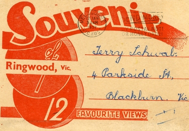
Souvenir - Folder, Samuel Lee and Co, 12 Black and White Souvenir photos of Ringwood, 1975, 1957
Souvenir photos sent to Terry Schwab in 1957 from Mick who hoped he would have many memories of Ringwood. Donated to the Society by Terry.Buff coloured folder with red printing containing 12 black and white favourite photos of Ringwood. Streetscapes, buildings and Ringwood lake. 4 separated from rest. From Mick. +Additional Keywords: Schwab,Terry -
 Ringwood and District Historical Society
Photograph, View south up New Street from reserve on the bank of the Mullum Creek. 1981
Written on back of photograph, "16/6/81. View south up New Street from reserve on the bank of the Mullum Creek." -
 Ringwood and District Historical Society
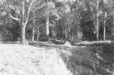
Photograph, View along the bank of the Mullum Creek at the foot of New Street 1981
Written on back of photograph, "16/7/81. View along the bank of the Mullum Creek at the foot of New Street." -
 Ringwood and District Historical Society
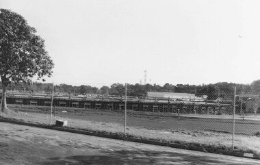
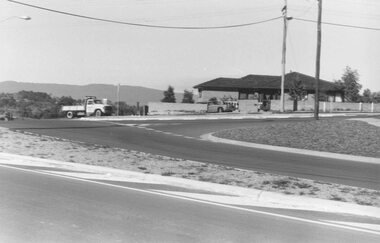
Photograph, View of forming of ground floor of Target 1981
Written on back of photograph, "6/6/81. View of forming of ground floor of Target." -
 Ringwood and District Historical Society
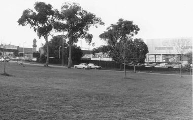
Photograph, Looking south-east from Staley Reserve 1981
View shows Ringwood Disposals, Guests Furniture and Clock TowerWritten on back of photograph, "6/6/81. Looking south-east from Staley Reserve." -
 Ringwood and District Historical Society
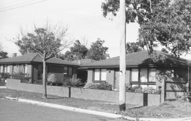
Photograph, View of Units at 49-41 Bond Street Ringwood - 1981
Written on back of photograph, "6/6/81. Units 49-41 Bond St." -
 Ringwood and District Historical Society
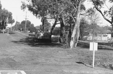
Photograph, View Southwest across the Wonga-Oban Roads roundabout. 1981
Written on back of photograph, "1/7/81. View Southwest across the Wonga-Oban Roads roundabout. Oban Road in foreground. Wonga Rd goes right up centre" -
 Ringwood and District Historical Society
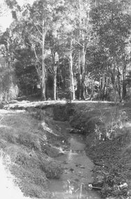
Photograph, View along Mullum Creek in the reserve at foot of New Street 1981
Written on back of photograph, "16/6/81. View along Mullum Creek in the reserve at foot of New Street. The water was clear" -
 Ringwood and District Historical Society
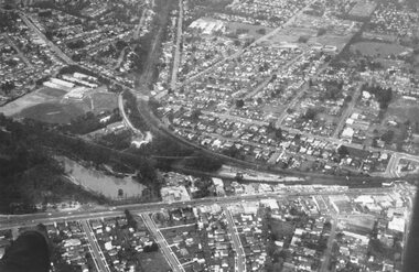
Photograph, Aerial view taken from slide - Ringwood Lake and surrounds 1969
Written on plastic sleeve, "Aerial view taken from slide - Ringwood Lake 7/8/69". -
 Ringwood and District Historical Society
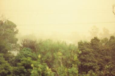
Photograph, View west from 79 Wantirna Road. Approaching dust storm 1983
Catalogue card reads, "View west from 79 Wantirna Road. Approaching dust storm. Temperature 3 p.m. 43.5C. 8/2/1983". -
 Ringwood and District Historical Society
Photograph, View of buildings on Maroondah Highway, Ringwood, taken overlooking railway yard from Station Street and Greenwood Avenue - 1914
Enlarged copy of smaller archived photograph - view of buildings on Maroondah Hwy taken overlooking railway yard from Station Street and Greenwood Avenue, 1914. Black and white photo on heavy cardboard backing. -
 Ringwood and District Historical Society
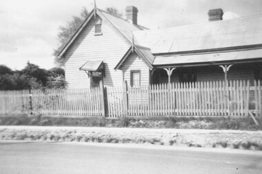
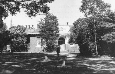
Photograph, Ringwood State School schoolmaster's residence. 1945
The residence was relocated from school number 2242 in Heatherdale Road (Mitcham) south of the railway line to this site in Ringwood Street opposite Charter Street where it adjoined the school when it opened at the corner of Maroondah Highway in 1889. For Rear View of the residence see record 6855Written below photograph, "Old schoolmasters residence - Ringwood St. - 1945". Written on back of one of smaller copies, "Was used as a residence by Mr. D. Broben(?) H.? No2977 for many years. Photo taken by Miss Joyce Russell for J. K. McCaskill. Bedford Rd." -
 Ringwood and District Historical Society
Photograph, Foundation stone for Ringwood State School No. 2997, laid by Mrs. J.K. Turnbull on 15th August, 1889
Photograph of Foundation stone for Ringwood State School No. 2997 was laid by Mrs. J.K. Turnbull on 15th August, 1889, marking the opening of the school situated in Whitehorse Road at the corner of Ringwood Street (1889-1922). Mrs. Turnbull was the wife of the Ringwood Station Master. The stone was removed after the school closed in 1922 and re-laid in 1962 by the School Committee at this subsequent Greenwood Avenue school site and is pictured here being viewed near the entrance in 1973 by Mr. Ron Pullin, Archivist, Ringwood Historical Research Group".Sign below photograph reads, "Foundation stone of Ringwood State School (late Ringwood St.). Now in grounds of Greenwood Avenue Ringwood State School". Inscription on stone, "This foundation stone was laid by Mrs. J.K. Turnbull on 15th August 1889". Printed on plaque below stone, "No.2997 - Ringwood State School 1889-1922. Situated in Ringwood Street, East Side sixty yards north of Maroondah Highway. Foundation stone removed 19?? re-erected by the School Committee 1962". -
 Ringwood and District Historical Society
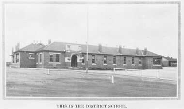
Photograph, Ringwood State School photograph for land sale - Charm-View Estate, Heathmont - 1926
Printed below picture, "This is the district school". Written on back of photograph, "Photo taken from Sub. Div. Plan Land Sale Charm-View Estate, Heathmont. 1926?"