Showing 22487 items matching "will park"
-
 Eltham District Historical Society Inc
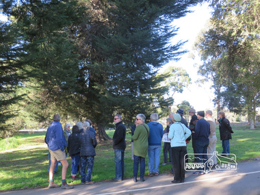
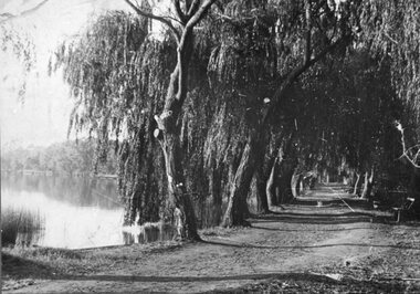
Photograph, Liz Pidgeon, Heritage Excursion; Eltham Lower Park Walk and Talk, 1 July 2017, 1 July 2017
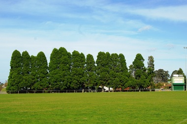
Newsletter No., 234, June 2017 Heritage Excursion - Saturday 1st July - Eltham Lower Park - Walk and Talk Eltham Lower Park has played an important part in the history of our area since the early days of European settlement when it was used by local residents as an informal racecourse. Prior to that its location at the junction of the Diamond Creek and the Yarra River made it an important meeting place for the Wurundjeri people. The park combines formal elements and sporting facilities with remnant bushland that is of environmental significance. It is home to sporting and horse riding clubs, popular play spaces and the Diamond Valley Miniature Railway, which attracts large numbers of visitors. The park will be the venue for our July excursion which will comprise a walk of about 3.5 km around the park and adjacent areas. Along the way we will discuss the history and natural history of the area. The path along the creek and the river provides a pleasant and scenic walk. This walk on Saturday 1st July is about 3.5 km in length and will take 2 to 2.5 hours. It will start at 2pm at the Main Road car park at the front of the park. (Melway ref 21 H 10). Born Digitalheritage excursion, activities, eltham district historical society, eltham lower park -
 Eltham District Historical Society Inc
Photograph, Liz Pidgeon, Heritage Excursion; Eltham Lower Park Walk and Talk, 1 July 2017, 1 July 2017
Newsletter No., 234, June 2017 Heritage Excursion - Saturday 1st July - Eltham Lower Park - Walk and Talk Eltham Lower Park has played an important part in the history of our area since the early days of European settlement when it was used by local residents as an informal racecourse. Prior to that its location at the junction of the Diamond Creek and the Yarra River made it an important meeting place for the Wurundjeri people. The park combines formal elements and sporting facilities with remnant bushland that is of environmental significance. It is home to sporting and horse riding clubs, popular play spaces and the Diamond Valley Miniature Railway, which attracts large numbers of visitors. The park will be the venue for our July excursion which will comprise a walk of about 3.5 km around the park and adjacent areas. Along the way we will discuss the history and natural history of the area. The path along the creek and the river provides a pleasant and scenic walk. This walk on Saturday 1st July is about 3.5 km in length and will take 2 to 2.5 hours. It will start at 2pm at the Main Road car park at the front of the park. (Melway ref 21 H 10). Born Digitalheritage excursion, activities, eltham district historical society, eltham lower park, sign, shared path -
 Melbourne Tram Museum
Ephemera - Timetable, Melbourne & Metropolitan Tramways Board (MMTB), Set of 14 MMTB Bus timetables, Jul. 1969
All July 1969 - no route numbers shown. .1 - Box Hill - Heidelberg - Templestowe .2 - East Kew - Box Hill - Doncaster .3 - Deer Park - Sunshine Park - Sunshine - Footscray - City .4 - Fishermen's Bend - City .5 - Williamstown Rd - Footscray Railway Stn - Ballarat Rd .6 - Garden City - City .7 - La Trobe University - Northland - West Heidelberg - City .8 - Box Hill - North Blackburn .9 - Bulleen - North Kew - City .10 - Clifton Hill - Elsternwick .11 - Box Hill - East Doncaster - Mitcham - Ringwood .12 - Deer Park - Sunshine Park - Sunshine - Footscray - City - Saturdays and Sundays - printed on pink paper. 13 - Warrandyte - Donvale Post Office - City 14 - Warrandyte - Park Orchards, Ringwood.Yields information about MMTB Bus services July 1969Set of 14 MMTB Bus timetables, folded sheets, providing timetables for specific routes, day of week giving information on tram times at specific time points, route map, sections and fares and organisation address - 616 Little Collins St. Melbourne.trams, tramways, timetables, tickets, bus services, fares, mmtb -
 Orbost & District Historical Society
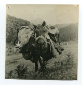
black and white photograph
This is a photograph of "Whalebone", a packhorse belonging to Jimmy Parkes.In the late 1800's early 1900's transporting goods by road was difficult and at times impossible because roads as thoroughfares did not exist.The means of travelling along the roads in the 1800's was by bullock wagon, horse pulled dray, pack horse or simply by foot.A small black / white photograph close-up of a packhorse with a full load. -
 Greensborough Historical Society
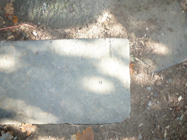
Photograph - Digital image, Park stones, Greensborough Lower Park, 02/05/2013
Photograph of stones located in Greensborough's Lower Park.Digital copy of colour photographs. -
 Greensborough Historical Society
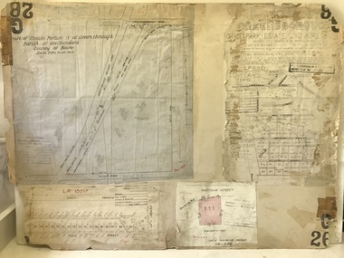
Planning document, City of Heidelberg, Subdivision Plan # G26. Grace Park Estate Greensborough, 1950c
Plan of Subdivision (G26). Grace Park Estate. An example of hard copy subdivision plans from the Greensborough area. From Shire of Heidelberg.Plan mounted on heavy card.Stamped and handwritten Council permissions, dates and other details.subdivision plans, grace park -
 Greensborough Historical Society
Photograph - Digital image, Marilyn Smith, Greensborough War Memorial Park Treescape in 2014, 02/08/2014
This photograph shows War Memorial Park Greensborough. Digital copy of colour photograph.greensborough war memorial park -
 Cheese World Museum
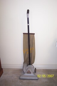
Vacuum cleaner, Scott and Fetzer Co
Used by the Uebergang family of Tooram Park, Allansford.Upright hand-propelled vacuum cleaner has a canvas bag suspended by a spring with stencilled brand name and two rear wheels.Vacuette Special/ Model C Serial number 597887 Distributed by Sole Distributors/Vacuette Distributing Company, London Stores bldg., Melbourne, Australia/Guaranteed service.allansford, uebergang, vacuette, london stores, scott & fetzer, cleaning equipment, vacuum cleaners -
 Eltham District Historical Society Inc
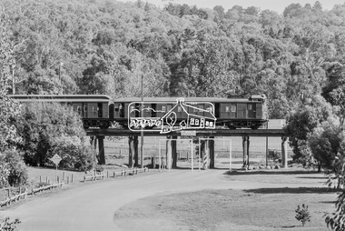
Photograph, George Coop, A Tait (Red Rattler ) train crosses the Eltham Railway Trestle Bridge at Panther Place, Eltham, 7-8 February 1981, 1981
Eltham Central Park viewed through the bridgeDigital TIFF file Scan of 35mm Ilford FP4 black and white transparency435m, eltham central park, eltham trestle bridge, hurstbridge line, panther place, red rattler, tait train -
 Lake Bolac & District Historical Society
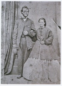
Black and white photograph, Josiah and Mary Park
Josiah and Mary Park, (1867) of Lake Bolac. -
 Creswick Campus Historical Collection - University of Melbourne
Document, 1952
Report of the State Development Committee on National ParksReport -
Stawell Historical Society Inc
Book - Report, The Future of the Grampians - Every Last Stick, 1979
Prior to Grampians National Parks - Draft PlansPaper with Red Paper Cover StapledLogo CCV - Conservation Council of Victoria -
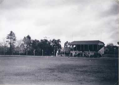 Stawell Historical Society Inc
Photograph, Central Park No1 Grandstand possibly c1950
Central Park No1 Grandstand possibly c1950.stawell -
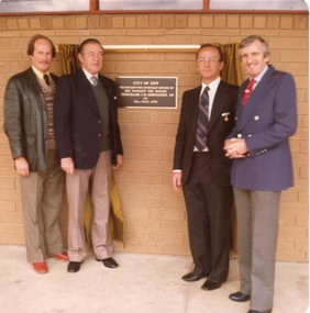 Ballarat Heritage Services
Photograph - Colour photograph, Opening of the Stradbroke Park Pavilion in Kew, 1979, 1979
Stradbroke Park is a sporting facility in the City of Kew. The Premier of Victoria (Rupert Hamer), the Mayor of Kew (Cr Jack Gervasoni), Cr Alan Hutchinson, and Kew Town Clerk Les Fell. city of kew, stranbroke park, alan hutchinson, john hogan gervasoni, jack gervasoni, rupert hamer -
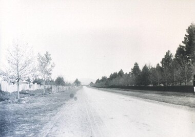 City of Ballarat Libraries
Photograph - Card Box Photographs, Victoria Park, Ballarat circa 1910
View of Victoria Park along Russell Street. victoria park, russell street, ballarat, streetscape, park -
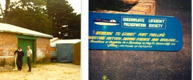 Queenscliffe Maritime Museum
Photograph - Queenscliffe Maritime Museum (QMM) 1984 Before built, QMM before construction 1984, Newspapers
BoQ Inspectors outside shed in Princess ParkHistorical photos of early days of QMM build, c1981Colour photos of early QMM construction, c1981Reverse " inspection holes for foundations / Mr Col Cairns & Mr Henry Hudson / Outside Queenscliffe 22 Dec 1981 / Gil Allbutt photographer ".historical references -
 Stawell Historical Society Inc
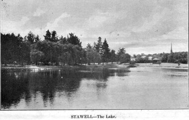
Postcard, Cato Lake earlier called Victoria Park
Cato Lake earlier called Victoria Park stawell -
 Stawell Historical Society Inc
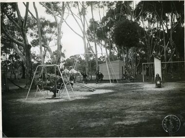
Photograph, Grampians Gate Caravan Park Playground c1940
Grampians Gate Caravan Park Playground c1940stawell halls gap -
 Stawell Historical Society Inc
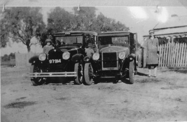
Photograph, Two sedan Cars parked in front of a residence
Two sedan Cars parked in front of residence.stawell transport -
 Stawell Historical Society Inc
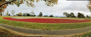
Photograph, Amateur Athletic Track at North Park 2015 -- Coloured
Amateur Athletic Track – North Park 2015stawell -
 Stawell Historical Society Inc
Photograph, Stawell Cato Park's Willow Trees c1930
Scene Willow Trees at Cato Park c1930stawell -
 Stawell Historical Society Inc
Photograph, Central Park Easter Gift c1950's
Central Park Easter Gift 1950'sstawell sport -
Friends of Ballarat Botanical Gardens History Group
Work on paper - Victoria Park, Ballarat, A Brief Chronology 1861-1929, Unknown
A brief though useful chronology of Victoria ParkVictoria Park has featured in the history of Ballarat since 1861.1 page of large print in point form with a bullet for each point.Nonevictoria park, ballarat council, mining companies, arbor day, trees, clegg and nicholls, guilfoyle, f.w.niven, pinus radiata, friends of ballarat botanical gardens, john garner, doctor john garner, john garner collection, gardens, ballarat -
 Wonga Park Community Cottage History Group
Photograph (Item) - Black and White, Wonga Park: Read's Dam, Orchard and House, c. 1931
Wonga Park: Read's Dam, Orchard and HousePhoto is named 14880016.jpg on CD -
 Linton and District Historical Society Inc
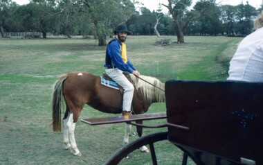
Photograph, Len McDonald in Period Costume, 1983, 1983
Participating in LDHS exhibition at Linton Park, 1983.Colour photograph of bearded man wearing hat, blue shirt, yellow tie and white trousers, riding horse in country setting, part of buggy in foreground."Len McDonald 9A".ldhs activities, ldhs exhibition linton park 1983, len mcdonald -
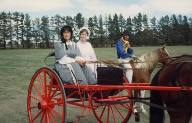 Linton and District Historical Society Inc
Photograph, Len McDonald, Faye Mason and Cheryl McDonald in Period Costume, 1983, 1983
Participants in LDHS exhibition at Linton Park 1983.Colour photograph of two ladies wearing period costumes driving horse drawn buggy with man riding horse beside."Len McDonald, Gaye Mason, (D. Jim) Cheryl McDonald (nee Rutherford)".ldhs activities, ldhs exhibition linton park 1983, len mcdonald, faye mason, cheryl mcdonald -
 Warrnambool and District Historical Society Inc.
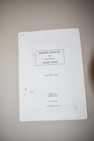
Booklet, Samuel Baulch and the Original Rose Park
This booklet contains the first draft of an article on Samuel Baulch’s acquisition of his property, Rose Park which was in the Macarthur/Hawkesdale district. Samuel Baulch’s parents, Francis and Ann Baulch were pioneer settlers in the Kirkstall area and Samuel worked at the Dunmore Station in the Macarthur area before purchasing the property he named Rose Park in the early 1870s. In the 1890s he acquired property in the Dunmore Estate. Samuel’s son, Stan Baulch, acquired sections of the Dunmore property after his father’s death and he named his section, Rose Park, a property to the west of the original Rose Park. This article is of historical interest and will be useful to researchers of local and family history. This is a booklet of 18 pages. It has a paper cover and the pages were originally stapled together but now have a plastic clip. The booklet has been home-produced and the material typed on a computer. Some of the pages are a little stained. samuel baulch, rose park, western victoria, history of warrnambool -
 Eltham District Historical Society Inc
Photograph - Digital Photograph, Marguerite Marshall, Eltham Lower Park, 20 April 2008
Originally a race course, the park has brought the community together with a variety of activities. Published: Nillumbik Now and Then / Marguerite Marshall 2008; photographs Alan King with Marguerite Marshall.; p45 Once used for horse racing, which attracted visitors from Melbourne, the Eltham Lower Park has brought the community together with a wide range of activities. Horse riding is now enjoyed as a recreation in the park as are other sports. The park also includes the Diamond Valley Railway miniature trains and a sanctuary for the rare and vulnerable Eltham Copper Butterfly. Eltham Lower Park, with other parks, forms an almost continuous green band from Eltham’s centre, along the Diamond Creek to the Yarra River.1 Before European settlement the Wurundjeri people met on this land, particularly at the junction of the Diamond Creek with the Yarra River, which they called Birr-arung. This is commemorated by the sculpture, Not just a Pretty Place by Aleks Danko, winner of the 2000 Nillumbik Art in Public Places Award. The first European to settle here was probably Henry Foley, who in 1841 used it as part of his pastoral run. Foley sold his leasehold to Joseph Wilson in 1845, who soon after sold it to Frederick Falkiner. During the 1840s the future park was part of a government square mile (2.6 sqkm) reserve, north of the Yarra, within the Parish of Nillumbik, later named Eltham. Soon the land was used for horse racing after nearby residents cleared ten acres (4ha) in the early 1850s. A three-quarter of a mile (1.2km) race secured the winner the £10 Publican’s Prize. In response to popular demand, the newly formed Eltham District Road Board petitioned the Surveyor General of the Colony of Victoria, in 1856, for 36 acres (14.6ha) of crown land for a racecourse and recreation. By 1858 the Eltham races had become an institution. ‘Many skirmishes occurred and the way home was paved with temptation, with sly-grog for sale.3 In the early 1870s, two jockeys were sons of the police officer in charge of the Eltham Police Station, Miles S Lyons. Another ten acres (4ha) was added to the area in 1866 and 12 acres (4.8ha) – Hohnes Hill – in 1870. In 1866, two acres (0.8ha) on the creek banks became an animal pound with William Walsh the pound keeper in 1870, but this was later incorporated into the park. By 1877 the area was called a public park but horse racing and training continued into the 1920s. In the mid-1900s trotters were trained on a circuit road. In 1953 the Eltham Pony Club was established and used a cross-country course on Hohnes Hill. From the mid 1950s the club held the Eltham Easter Fair at the park, later to include a procession along Main Road from the town centre to the park. The park also attracted picnic parties and campers from the inner suburbs as did Wingrove Park, and businesses catering for visitors, sprang up on the opposite side of Main Road. Bus-loads of school children visited the park for Gould League bird days in the 1960s. In 1979 the Eltham Shire Council bought Lenister Farm, linking the park with the Yarra River. The Lenister Farm wetland includes a bird hide, viewing platform and interpretive signs.5 Pioneer Henry Stooke, later Road Board chairman, bought the 11 acres (4.5ha) - later to become Lenister Farm - from the Crown in 1862. Stooke never lived on this site and the two houses at Lenister Farm were built in the 20th century. Since its formation in 1871, the Council has controlled this crown land, which it named Eltham Park. But in the 1920s Eltham Council bought land near the town centre for a park, which it named Eltham Central Park. To avoid confusion the Council renamed Eltham Park, Eltham Lower Park. Since 2004 the Yarra footbridge has linked the park with the Yarra Valley Metropolitan Park and the Main Yarra Trail.This collection of almost 130 photos about places and people within the Shire of Nillumbik, an urban and rural municipality in Melbourne's north, contributes to an understanding of the history of the Shire. Published in 2008 immediately prior to the Black Saturday bushfires of February 7, 2009, it documents sites that were impacted, and in some cases destroyed by the fires. It includes photographs taken especially for the publication, creating a unique time capsule representing the Shire in the early 21st century. It remains the most recent comprehenesive publication devoted to the Shire's history connecting local residents to the past. nillumbik now and then (marshall-king) collection, eltham lower park, eltham park -
 Port Melbourne Historical & Preservation Society
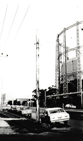
Photograph - Graham Street towards Albert Park, Reverend Donald LANGFORD, June 1973
Taken from the corner of Seisman Place looking towards Albert Park, the photograph was taken before the demolition of the gasometer shown on the on right. The original Albert Park High School can be seen behind the Pickles Street sign.B & W photograph of Graham Street, Port Melbourne looking towards Pickles Street.built environment - demolition, built environment - industrial, transport - roads, education - secondary schools, gasometer -
 Hume City Civic Collection
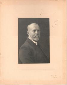
Photograph
It is possibly a portrait of the Rev. Goyer. The photo was sent while he was a minister at a church in Canterbury Road, Middle Park. Inscription on back: 'With best wishes from you old Minister "The Manse" Canterbury Road, Middle Park.A b/w portrait of a minister - possibly Rev. Goyer who was minister of St. Andrew's Church in Sunbury. The photo is mounted on cream cardboard with a cover sheet over it.Bottom Rh corner: Lafayette / Melbournegoyer, - (rev.), clergymen, churches, st. andrew's presbyterian church, sunbury, canterbury road, middle park, st andrew's uniting church, george evans collection