Showing 27796 items
matching yarra-river
-
 Kew Historical Society Inc
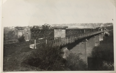
Photograph, Railway Viaduct, c.1919
The railway viaduct linking Kew and Fairfield was created for the Outer Circle railway.Railway viaduct, Yarra River, linking Kew and Fairfield. Built by John Monash for the Outer Circle Railway. In 1930 converted into the Chandler Highway Bridge for vehicular traffic. The point-of-view of the photograph shows Kew in the distance. Annotations on reverse: "Outer Circle Railway Bridge (now Chandler Highway) Fairfield-Kew, about 1919. Property of Miss Foley.outer circle railway, railway viaduct (kew), john monash -
 University of Melbourne, Burnley Campus Archives
Photograph - Black and white print, Aerial View of Burnley Campus, 1977
Framed enlargements. (A) Burnley College and surrounding suburbs showing the nearly constructed Freeway, the College in the bend of the Yarra River, Glenferrie Road to the East Swan Street to the North. (B) Enlargement of (A) showing detail of Burnley College.burnley college, suburbs, freeway, yarra river, glenferrie road, east swan street, aerial view -
 Melbourne Tram Museum
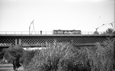
Negative, Wal Jack, c1941
Black and white negative, by Wal Jack, of W2 392 (from information in the Wal Jack Album) crossing the Swan St or Wallen St bridge over the Yarra River. Photo not dated, in the Wal Jack album.trams, tramways, swan st, wallen road, bridges, w2 class, yarra river, tram 392 -
 Mission to Seafarers Victoria
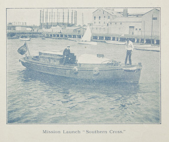
Photograph, Mission Launch Southern Cross, c. 1910
The motor boat built by Charles Blunt was donated in 1906, and was useful for ships' visit.Printed photograph published in the Annual Report for 1910 on page 35, depicting Reverend Alfred Gurney Goldsmith on board the mission's motor boat with another man. The image was taken on the Yarra River near the Docklands Gasworks.alfred gurney goldsmtih, motor boat, motor launch, southern cross, yarra river, gasworks, docklands, flinders street, charles blunt, blunt boatbuilders, geelong -
 Bunjil Park Aboriginal Education & Cultural Centre
boomerang, (estimated); late 20th century
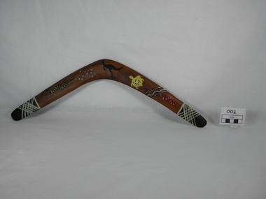
boomerang made from Murray River Red Gum timber. decorated boomerang, used for killing low flying ducks. Each end has a black tip with white cross hatching. Animal painted decorations from left to right are: black snake with yellow stripes, ochre platypus, black coloured kangaroo, yellow turtle, black, ochre and white wavy lines followed by a red snake with black and white stripes. On reverse apex of boomerang burnt into timber "Murray River / Red Gum"platypus, boomerang, river, decorated, hunting tool, snake, turtle, kangaroo, creek, duck hunting, ducks, jaara jaara, jaara jarra people -
 Kew Historical Society Inc
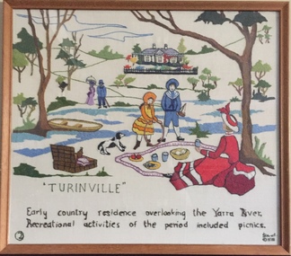
Textile - Bicentennial tapestry, 2. Turinville, 1988
This is one of eight embroidered panels, completed during the 1988 Australian Bi-Centennial, and carried out under the auspices of City of Kew Council and the Kew Historical Society. Nearly 600 residents, including many children, participated in their production by adding a few or more stitches. A book records their names and the panels upon which they worked. Artist: Joy Stewart / Co-ordinator: Dorothy Benyei.1. Turinville. A framed embroidery created by adults and children of the City of Kew as a Bicentennial project, based on a design by the artist Joy Stewart. Five of the six completed embroideries created in the project are/were displayed in the Kew Library. [The five embroidered panels have now been temporarily removed for conservation reasons].Inscription: "TURINVILLE / Early country residence overlooking the Yarra River. Recreational activities of the period included picnics" Embroidered signature of the artist: "(c) JStewart, 1988"bicentennial project (kew), joy stewart, charles grimes expedition, australian bicentennial -
Tatura Irrigation & Wartime Camps Museum
Photograph, Big Eildon Project, 1953
Taken by photographer for State Rivers and Water Supply Commission.Large sepia photograph. Earthmoving equipment in right foreground and middle distance, men scattered around site working, side of hill being excavated, rounded hills beyond forming horizon.Below photo: "BIG EILDON PROJECT / Construction of Embankment across Goulburn River Bed / Work commenced November 1953." victoria state rivers and water supply commission, eildon, goulburn river -
 Orbost & District Historical Society
black and white photographs, 25.11.1976
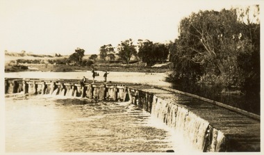
These photographs were taken on November 25, 1976 at the official opening of the current Snowy River road bridge. Included in the photographs are: John Duggan; Pat Hall, C.R.B. chairman, R.E.V. Donaldson (3240.7) and J.A.Rafferty, the state minister for Transport, who cut the ribbon (3240.8). Di Young and Cheryl Dusting (3240.9) distributed souvenir information pamphlets to official guests. The Snowy River road bridge is one of four built as part of the 8.4 km project spanning the Orbost flood plains. The Snowy River bridge and another over the nearby Ashbys Gulch are among the 10 longest bridges in Victoria, being the eighth and fifth longest respectively. The new bridge removed through traffic from Orbost township crossing the Snowy River 45 m downstream of the old bridge.This bridge is the fourth to provide a crossing to the township of Orbost. (info from CRB NEWS No. 34. DECEMBER, 1976) These photographs are pictorial records of a significant event in Orbost's history.Eleven black / white photographs all related to the official opening of the current Snowy River Bridge. Details are in catalogue folder.snowy-river-bridge -
 Greensborough Historical Society
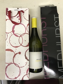
Bottle and Apron, Primary Edge Promotions, Medhurst Bottle and Apron, 2016_
Medhurst Wines operates in Gruyere, Yarra Valley. The winery is on land once owned by David Medhurst, formerly of Greensborough. These items were a gift to David's descendant, Faye Fort (nee Partington).Clear glass wine bottle 750 ml, screw cap, in black cardboard presentation box in red and white gift bagLabelled Medhurst Chardonnay 2016 Yarra Valley; with, black poly cotton apron, with pocket, embroidered Medhurst in white.medhurst family, medhurst wines yarra valley -
 Melbourne Legacy
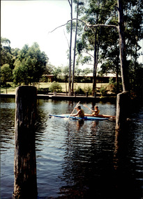
Photograph - Junior legatee outing, Kayaking, 1990s
Legacy have many programs to send junior legatees on activities, camps and outings. The photos are of junior legatees kayaking on a river. It was possibly part of a camp. The date is not known though it was stored with other photos of Junior Legatees from the 1980s and 1990s. A record of a Legacy providing experiences for the junior legatees.Colour photo x 4 of Junior Legatees kayaking on a river and returning the kayaks to a shed.junior legatee outing, kayaking, kayaks -
 Orbost & District Historical Society
black and white photograph, late 19th - early 20th century
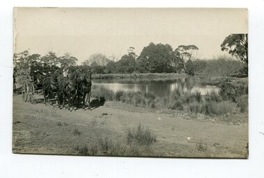
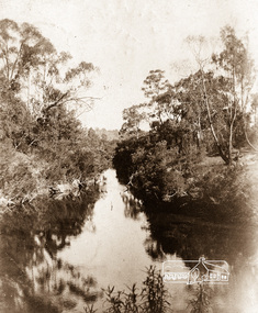
This photograph was taken at the junction of the Snowy and Brodribb Rivers. The Snowy River starts in New South Wales on the slopes of Mt Kosciuszko, Australia’s highest mountain, in New South Wales. It flows into Bass Strait at Marlo in Victoria. The Brodribb River is a tributary of the Snowy which enters the estuary at Marlo. This is a pictorial record of a road in Marlo near Orbost in the late 19th-early 20th centuries. It also depicts the transport used at that time.A black / white photograph of four men in suits seated in a horse - drawn buggy on a dirt road alongside a creek or river. There appears to be another horse - drawn vehicle behind them.on back - "at the Brodribb - Snowy junction. this road was corduroy (packed logs of tea trees?)brodribb-river snowy-river marlo transport-horse-drawn -
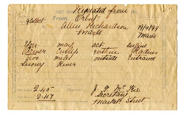 Orbost & District Historical Society
telegram, April 1899
This message concerned the P.S. Curlip's entry to the Snowy River Lakes Entrance. It was logged at 2:45 and received at 2:47.This item is associated with the P.S. Curlip and the Richardson family, early Orbost pioneers.A white paper telegram with blue print and details hand-written in black ink. It has been sent fro Orbost to "Allen Richardson Marlo". The handwritten message is difficult to decipher."You may enter - engine driver Curlip within two miles outside Entrance Snowy River."telegram-richardson-curlip communications-19th-century -
Bendigo Historical Society Inc.
Plan - MARKS COLLECTION: PLAN OF G. LANSELL'S GOVERNOR'S PARK, TOORAK
Plan (tightly rolled) drawn on heavy paper mounted on fabric. On top of plan printed 'Governor's Park Toorak, late Vice-Regal Estate, the property of G. Lansell Esq' On top of plan Yarra Yarra River, on bottom Toorak Road, Plan shows subdivision, in centre of which is drawn outline of 8 acres containing the 'Mansion and Grounds'.bendigo, hospital -
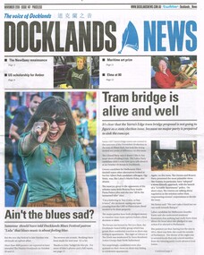 Melbourne Tram Museum
Newspaper, Docklands News, "Tram bridge is alive and well", Nov. 2018
Newspaper clipping from "Docklands News" - December 2018, No. 147, titled "Tram bridge is alive and well" about the possible construction of a tramway bridge over the Yarra River in the Docklands, Yarra Edge district and the relationship with the Vic. State election that was held on 24/11/2018. Clipping spreads over three pages. Discusses other election issues.trams, tramways, docklands, new tramway, bridges, yarra river -
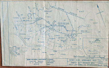 Orbost & District Historical Society
plan, December 1968
Brodribb floodplain regularly inundated in the late 1800s and early 1900s. Works included: clearing the river channel and blocking ‘gulches’. The meander was cut-off in 1931, as part of the Orbost East Drainage Scheme and further developed after 1934 floods and again in the early 1950s when levee banks and a regulator were constructed. (ref. East Gippsland Catchment Management)This is a useful reference tool.A hand-drawn plan of the layout of the levee banks of the Old Brodribb River.brodribb-river map plan-levee-banks -
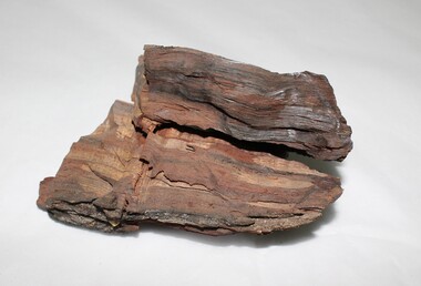 Wodonga & District Historical Society Inc
Geological specimen - Murray River Red Gum Geological Specimen c. 6000 BP
This wood was cut from a 6000 year old Murray River red gum retrieved from the Wodonga gravel pits on the flood plain. The Museum of Victoria displayed this wood in the base on which Phar Lap stands. It was made by Kevin Barton of the Kiewa Valley to the order of Dr. James Bowler, the geologist who dated the ancient gravel pit red gums. This specimen is historically significant and unique in local, national, and international context. It is unique, of scientific and research value, and exceptionally rare due to its age. 6000 year old wood from a Murray River red gum. geology, geological, murray river, red gym, murray river red gum, kiewa, wodonga, history -
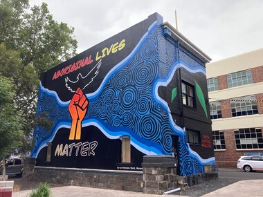 Yarra City Council
Artwork, other - Mural, Ky-ya Nicholson-Ward, Aboriginal Lives Matter, 2021
"The fist references the Black Lives Matter movement and also represents the strength of Indigenous peoples all over the world and symbolises solidarity and justice for everyone affected by systematic racism. Bunjil (wedge-tailed eagle) is flying high on the building. He is the creator spirit for Wurundjeri people who looks over us and protects us. Bunjil represents healing and power to our people. The blue circles and lines represent revival and waterways; in particular, they depict the Birrarung (Yarra River), which is very significant for the Wurundjeri people. Our people are known as the Manna Gum people. The leaves in the artwork highlight Wurundjeri people and their Country. These leaves also represent the cleansing of negative spirits. The Manna Gum leaf is also an important symbolic offering in our traditional Welcome to Country ceremony. Leaves are offered to visitors as they are granted safe passage through our land. They are made welcome to everything from the tops of the trees to the roots of the earth. We ask that they take care of the land, plants and animals and to respect the protocols and rules of the Traditional Owners whilst on our Country."In 2020 Council declared its support for the global Black Lives Matter (BLM) movement. In consultation with Yarra City Council's Yana Ngargna advisory group a motion was prepared and passed unanimously by all Councillors. A number of actions were generated from this decision; one of which was for Council to commission a large-scale mural that aligned with the movement. Emerging artist Ky-ya Nicholson-Ward, a proud Wurundjeri, Dja Dja Wurrung, Nguarai Illam-Wurrung, German and Irish woman, created the mural installed on a building in Peel Street Park, Collingwood. Selected by Council's Yana Ngargna, Black Lives Matter Working Group the artwork identifies the cultural importance of the local area to the Wurundjeri Woi Wurrung people as the Traditional Owners. With a strong focus on Aboriginal identity the mural outlines the local context of the Black Lives Matter movement, which is connected to racism, policing of Aboriginal and Torres Strait Islander peoples and associated deaths in custody. The artwork acknowledges the ongoing challenges faced by Aboriginal community members and their struggle to survive white systems, policies and institutions. Ky-ya's mural tells the story of Aboriginal resilience, strength and self-determination; and will support the process of healing. It is a celebration of the local Aboriginal and Torres Strait Islander community; the significant Aboriginal history of Fitzroy, Collingwood and surrounds; and community's continuing cultural connection to the area. Importantly, this artwork provides a platform to educate a broader audience about the local context of the Black Lives Matter movement and Aboriginal deaths in custody. The mural will activate this site, enliven the area, promote inclusion, incite conversation and contribute to the creative capital of this locale. A welcoming environment for Aboriginal and non-Aboriginal communities.Aboriginal Lives Matter Ky-ya Nicholson WardOn a black background a hand fist (strength, solidarity and justice) is placed at the centre of the building; Bunjil (wedge-tailed eagle) is depicted flying high on the building; blue circles and lines represent revival and waterways (Birrarung-Yarra River) and the leaves in the artwork highlight Wurundjeri people (cleansing of spirit and welcome to Country)The artist name 'Ky-ya Nicholson Ward' painted in white, low right of the wall facing into Peel Street Park. black lives matter (blm) movement, wurundjeri woi wurrung, bunjil, identity, birrarung, country -
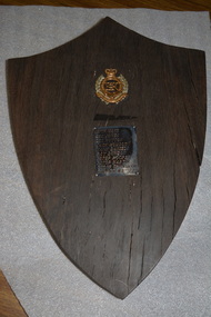 Wangaratta RSL Sub Branch
Shield, Original punt was made in the mid 1800s. shield was made by Jim Sloan in early 1970s
Red gum shield was made from a piece of the Ovens River punt which served as a river crossing at the Sydney Hotel two centuries ago and which had lain on the river bed for approximately 100 years. The punt was raised by members of the Royal Australian Engineers whose names, unit and badge apear on the shield in the early 1970s.Red gum shield was made from a piece of the Ovens River punt which served as a river crossing at the Sydney Hotel two centuries ago and which had lain on the river bed for approximately 100 years. The punt was raised by members of the Royal Australian Engineers whose names, unit and badge appear on the shield in the early 1970s. In 2019, after nearly 70 years at Balcke House, the Wangaratta RSL Sub Branch will take up new residence at the Sydney Hotel.Red Gum timber in shape of shield with crest and plaque.Crown of Australian Engineers above a list of the soldiers who worked on the project. Attached is a card which states :- This red gum shield was made from a piece of the Ovens River punt which served as a river crossing at the Sydney Hotel two centuries ago and which had lain on the river bed for approximately 100 years. The punt was raised by members of the Royal Australian Engineers whose names, unit and badge appear on the shield in the early 1970s. It was made and presented to the Wangaratta RSL by Jim Sloan of Wangaratta.ovens river, sydney hotel wangaratta -
 Whitehorse Historical Society Inc.
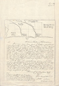
Document - Correspondence, Anderson's Station, 2/10/1842
Photocopy of a letter from James Anderson dated 2 October 1842 complaining of incursions by stock of Major Newman on Anderson's adjoining land. Includes sketch map of relative locations of neighbouring runs bordered by the Yarra River.anderson, james, newman, (major), dawsons station, ross station, yarra river, agriculture, pioneers, deep creek, nunawading -
 Kew Historical Society Inc
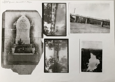
Photograph - Photocopy, Bryan Family Album, Twentieth Century
The Bryan family live din Princess Street, Kew.Photocopies of original photographs relating to or that belonged to the Bryan Family of Princess Street, Kew. The images include the headstone of Sarah Bryan and Anne Chambers; three photos of floods in Kew, one dated 1931; and a view of the River Yarra. bryan family (kew), kew -
 Orbost & District Historical Society
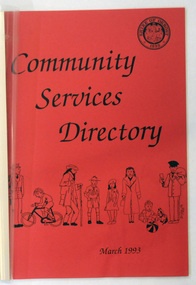
book / document, Community Services Directory March 1993 Shire of Orbost, 1993
This booklet was compiled by Orbost Shire council in 1993. It contains addresses and phone numbers of community groups in the shire and includes Mallacoota, Bemm River, Marlo, Cann River and Orbost.I it also has population statistics from the 1991 census - 6562 or the Shire of Orbost.This booklet is a useful reference tool.A foolscap sized document of approximately 60 pp titled COMMUNITY SERVICES DIRECTORY Shire of Orbost March 1993.It has a red cover with plastic binding. It contains addresses and phone numbers of community groups in the shire and includes Mallacoota, Bemm River, Marlo, Cann River and Orbost.I it also has population statistics from the 1991 census - 6562 or the Shire of Orbost.orbost-history community-groups-orbost-1993 -
 Orbost & District Historical Society
black and white photograph, 1884?
James Alexander Robertson was born 14th June, 1855, at Pentridge. the Coburg area which was known as Pentridge at the time, and prior to the building of the gaol. His parents were James Thomson Robertson and Esther (nee Hale), At age 20 James became the first selector on the Snowy River at Lochend. He took up Lots 1, 2 and 3, in the Parish of Newmerella in 1875; with his selection being ratified on May 1st, 1876. The selection included hill and river flat land in the area near where Icy Creek enters the Snowy River. James gradually improved and farmed the property; he cleared and drained Icy Creek and constructed the first known flood-gate on the Snowy River. To meet his farming commitments he supplemented his income by working on the construction and maintenance of roads and drains in the Newmerella area. He gained a contract with the Bairnsdale Shire council to construct the first road cutting down Burn’s Hill at Newmerella. His tender was for £16 ($32), and it took him, with four others, two months to complete the contract. He was single, and, after his untimely death at aged 29, in 1884, his parents and surviving unmarried sisters and brothers moved from Sarsfield to take over his selection at Lochend. (more information Newsletter April 2013)James Robertson was the first selector of land at Lochend, Orbost.A small black / white portrait photograph, oval shaped with a white background. It is of a middle-aged man with a full beard and moustache.on front at bottom - typed in black -:"James Alexander Robertson, Late of Lochend, Snowy River"robertson-james-alexander lochend-robertson -
 Kew Historical Society Inc
Photograph - Victorian Canoe Club, Dight's Falls, Studley Park, 1920-30
Canoeing on the River Yarra at Melbourne was an important and widespread recreational pursuit for Melbournians, especially in the first half of the twentieth century. The Victorian Canoe Club was formed in 1912 at a meeting in Melbourne and its first committee elected in the same year. Records indicate that the Club continued into at least the 1950s .The album has historic and social significance as a record of recreational activities (as well as canoe making) in the early years of the twentieth century. It has local significance as the site of the headquarters of the Club was in Studley Park. A number of photographs in the album provide vistas of Kew on the Yarra that are otherwise unavailable.One of 24 labelled photos in part album, originating from the Victorian Canoe Club, which had its headquarters in Studley Park, Kew. The album includes a photographic record of canoe construction and also locations in Studley Park and Kew where the canoes were used. The subject of this photograph is identified as 'Dight's Falls, Studley Park'.The view shows an early trestle bridge across the Falls on which people, possibly members of the Club, are standing. The point of view would appear to be looking up river towards Fairfield."Dyghts Falls, Studley Park"victorian canoe club, river yarra, burke road -- kew (vic.), dight's falls -- fairfield (vic.), dight's falls -- kew (vic.), dight's falls -- yarra river -
 National Wool Museum
Book, Modern Developments in the Australian Wool Industry
"Modern Developments in the Australian Wool Industry", c.1923. Examines the operations of the Yarra Falls Spinning Co. Pty Ltd and the Australian Knitting Mills Limited (makers of Golden Fleece and Kookaburra knitted underwear). Includes photos of processes and of the buildings.Book, front cover: "Modern Developments in the Australia Woollen Industry" c.1923; Yarra Falls Spinning Co. Pty Ltd and Australian Knitting Mills Limited.weaving textile industry - history textile production machine knitting textile mills, yarra falls spinning co. pty ltd australian knitting mills limited, yarn - woollen, cloth - worsted, yarn - worsted, wool tops, yarn - cashmere, logo merino: sheep in australian art and design - exhibition (29/07/2000 - 04/02/2001), weaving, textile industry - history, textile production, machine knitting, textile mills -
 Orbost & District Historical Society
black and white photograph, late 19th - early 20th century?
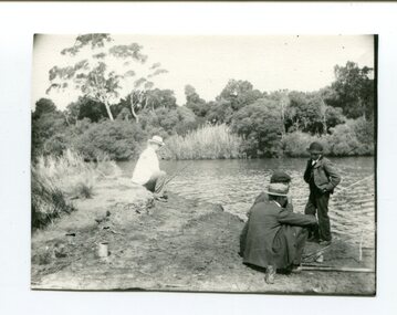
This photograph shows men fishing in the Snowy River at Marlo - possibly at Bream Point. The man in the white coat is Lancelot Herbert. Lancelot Herbert came to Orbost in 1886, taking up a partnership with local store-owner George Temple. After Mr Temple’s death in 1891, Lancelot took over the store and progressively developed Herberts Snowy River Stores which grew into a department store of several shops along Nicholson St. He also had small shops at Cann River, Noorinbee and Genoa which were run by members of his family, as well as a carrying business and fuel outlets. Lancelot died on 2/6/1911 and his wife Martha [died 1945] are buried in a joint grave in Orbost Cemetery. (info. Noreen and Lindsay Thomson. More from "In Times Gone By' by Deborah Hall)This item is associated with the Herbert family very early settlers in the Orbost district. It is also associated with Marlo which has always been a popular fishing destinationA small black / white photograph of four men fishing from a river bank. Three are sitting and one is standing.on back - Lancelot Herbert in white coat fishingfishing-marlo herbert-lancelot -
 Eltham District Historical Society Inc
Photograph postcard, Diamond Creek, Eltham; postcard dated 11 July 1906
View of the Diamond Creek as it enters the Yarra River, taken from the south side of ther Yarra.Digital file only Postcards scanned from the collection of Michael Aitken on loan to EDHS, 13 Feb 2018michael aitken collection, postcards, eltham, diamond creek, confluence -
 Port of Echuca
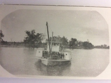
Black and white photograph, 1907
The P.S Canally was built in 1907 by R.W. Beer. Known as the "Greyhound of the River" after her original engine was substituted with a Railway locomotive, minus the wheels.The speed of the Canally set up tremendous wash, which sank any small craft. In 1929 it was sold to N. Collins who converted it to a barge. The Chislett Brothers were the owners when the P.S Canally sank at Boundary Bend in 1962. (Ref . Parsons R. "Ships of the Inland Rivers." P.58.)The P.S.Canally is significant because it was fitted with a locomotive, minus the wheels. This is significant because it shows the need for the paddle steamers to travel fast. This could show the competitiveness of the paddle steamer trade on the river in the early 20th Century. A small black and white photograph of an old photograph of the P.S Canally in the middle of the river. The paddle steamer is travelling towards the camera. p.s canally, beer, r.w., chislett brothers, collins, n. -
 Orbost & District Historical Society
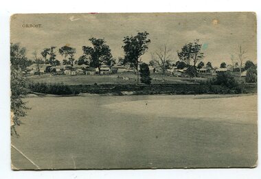
black and white photograph, Campbell. D.S, late 19th century ?
This is a photograph of the settlement of Orbost on the banks of the Snowy River,. In the foreground in the paddock there is a water trough (Bills?) and the B Drain can be seen on the far left. D.S. Campbell had a stationery store in Nicholson Street Orbost and published several black and white postcards of Orbost.This is a pictorial record o The township of Orbost in the late 19th century.A black / white photograph / postcard. There is a river in the foreground with houses and shops in the background behind a cleared paddock.on front - Orbostorbost-19th-century snowy-river -
 Kew Historical Society Inc
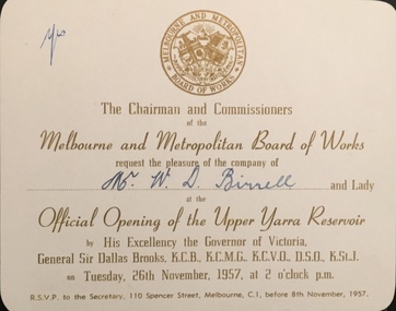
Document (item) - Invitation to the Official Opening of the Upper Yarra Reservoir, Melbourne and Metropolitan Board of Works, 1957
The Municipality of Kew (1860-1863), the Borough of Kew (1863-1910), the Town of Kew (1910-1921) and the City of Kew (1921-1994) were local government instrumentalities in the State of Victoria. In 1994, the City of Kew was amalgamated, together with the former Cities of Camberwell and Hawthorn, into the new City of Boroondara (1994- ). Like other local government entities of the period, Kew was administered by town clerks. The two notable town clerks in Kew's history were H. H. (Henry Hirst) Harrison (1868-1955) and W. D. (William Dickie) Birrell (1899-1974). Harrison was appointed to the position in 1901 and retired in 1938 after 37 years. Birrell, appointed Acting Town Clerk in 1921, became Town Clerk in 1938, following Harrison's retirement. He continued in this role until his retirement in 1966.This card is part of an historically significant civic collection, containing hundreds of separate invitations, documents, greeting cards, programmes and tickets issued and/or collected by successive town clerks. Items in the collection illuminate the political, social and cultural history of the district. As a continuous record, ranging across most decades of the Twentieth Century, they reveal changing tastes in design, values and relationships in the history of local government in Victoria.THE CHAIRMEN AND COMMISSIONERS / OF THE MELBOURNE AND METROPOLITAN BOARD OF WORKS / REQUEST THE / PLEASURE OF THE COMPANY OF / Mr W D Birrell / AT THE / OPENING OF THE UPPER YARRA RESERVOIR / BY HIS EXCELLENCY THE GOVERNOR OF VICTORIA / GENERAL SIR DALLAS BROOKS KCB KCMG KCVO DSO KStJ / ON TUESDAY, 26TH NOVEMBER, 1957, AT 2 O'CLOCK P.M. / RSVP TO THE SECRETARY, 110 SPENCER STREET, MELBOURNE, C1, BEFORE 8TH NOVEMBER, 1957civic invitations -- kew (vic), melbourne & metropolitan board of works, upper yarra reservoir -
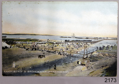 Flagstaff Hill Maritime Museum and Village
Postcard - Coastal Scene, Joseph Jordan, Sandy beach & breakwater Warrnambool, 1910
The coloured postcard depicts the Port of Warrnambool in the early 1900s. It shows the Breakwater, completed in 1890, the Viaduct, and the Merri River footbridge. There are many people on the sandy river banks, beach and bridge, and some are on the rocks of Middle Island. The printed postcard was made in England and is one of the Jordan Series produced by Joseph Jordan, a renowned photographer in Victoria's Western District.The postcard is locally significant as a record of the early footbridge over the Merri River, and the Viaduct before the space between the pylons was filled it. It shows the use of horses as a means of transportation. The photograph is also associated with Joseph Jordan, a renowned Victoria's Western District photographer.Postcard, coloured, showing the Port of Warrnambool. People are gathered on the sandy beach beside the river and near the river mouth. They are on and below the footbridge, along with several horses. Some are on the rocky Middle Island. There is a white ship in port. There is a jetty on the left, and buildings at the start of the breakwater. An inscription is printed at the bottom of the picture. The picture is one of the Jordan Series. It was printed in England in 1910."SANDY BEACH & BREAKWATER AT WARRNAMBOOL" "JORDAN SERIES" "PRINTED IN ENGLAND" "1910"warrnambool, shipwreck coast, flagstaff hill, flagstaff hill maritime museum, flagstaff hill maritime village, postcard, merri river, footbridge, warrnambool breakwater, breakwater, viaduct, middle island, port of warrnambool, jordan series, printed in england, 1910, joseph jordan, jordan photography