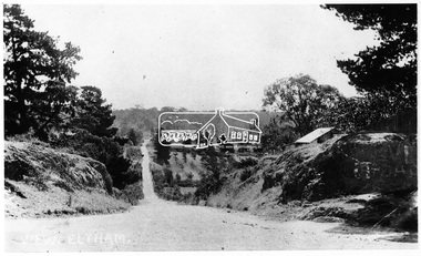
Showing 10199 items
matching main road
-
 Whitehorse Historical Society Inc.
Document - Correspondence, Healesville Road, 18/06/1937
... expended on Main Healesville Road by Shire of Blackburn and Mitcham... for reimbursement from Country Roads Board of amounts expended on Main ...Claim for reimbursement from Country Roads Board of amounts expended on Main Healesville Road by Shire of Blackburn and Mitchamshire of blackburn and mitcham, victoria. country roads board, roads and streets, healesville road -
 Eltham District Historical Society Inc
Negative - Photograph, View, Bridge Street, Eltham, c.1890
... View towards Montmorency Estate from Main Road, Eltham... melbourne View towards Montmorency Estate from Main Road, Eltham ...View towards Montmorency Estate from Main Road, Eltham about 1890. Looking down Bridge Street across the bridge (1875). At the corner of Susan Street is the Hill family home. Reproduced in "Montmorency; the farm on the Plenty" by Maureen Jones, 2015, p43 - 'View towards Montmorency Estate from main Road, Eltham, c.1890'This photo forms part of a collection of photographs gathered by the Shire of Eltham for their centenary project book,"Pioneers and Painters: 100 years of the Shire of Eltham" by Alan Marshall (1971). The collection of over 500 images is held in partnership between Eltham District Historical Society and Yarra Plenty Regional Library (Eltham Library) and is now formally known as 'The Shire of Eltham Pioneers Photograph Collection.' It is significant in being the first community sourced collection representing the places and people of the Shire's first one hundred years.Digital image 4 x 5 inch B&W Negshire of eltham pioneers photograph collection, eltham, bridge street, bridge street bridge, hill family home, montmorency, susan street -
 Ballarat Tramway Museum
document - Typed Notes, "Track Grades" and "Tramway Route Distances", 1953
... , east from Main Road, location of sharpest curve (Main Road..., east from Main Road, location of sharpest curve (Main Road ...Yields information about the curves and grades and track distances in Ballarat on its tramways.Typed notes titled 1. - "Tramway Route Distances" detailing the distances in Ballarat over the various routes and within the city, often measured from building lines, provided in chains. Typed 12/3/1953, initials "WM" 2 - "Track Grades" - for Sturt St, South track between Albert and Lydiard St (south side), North side (between Courier Office and Lydiard St", Victoria St, east from Main Road, location of sharpest curve (Main Road into Barkly St), Dawson St crossover, Contained within Reg Item 5507 - Foolscap binder with green covers, black binding edge and metal clips. track, ballarat -
 Eltham District Historical Society Inc
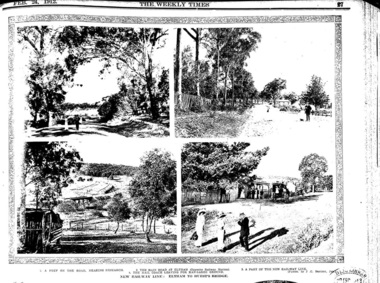
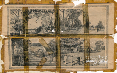
Newspaper clipping, 3. A part of the new railway line.; New Railway Line: Eltham to Hurst's Bridge; The Weekly Times, 24 Feb 1912, p27, 1912
... on the road, nearing Research. 2. The Main Road at Eltham (opposite... on the road, nearing Research. 2. The Main Road at Eltham (opposite ...Pages from a scrapbook belonging to Heather Jenkins (nee Sargeant) who lived as a child in the Police Residence at 728 Main Road, Eltham in the 1920s. Images featured are 1. A peep on the road, nearing Research. 2. The Main Road at Eltham (opposite Railway Station). 3. A part of the new railway line. 4. The mail coach leaving for Kangaroo Ground.Heather Sargeant was the daughter of Constable W.C. Sargeant, the local police officer in residence at Eltham, 1922-1927Detail from large newspaper clipping (half page), very aged and fragile with sticky tape holding it together with 4 images of early Elthameltham, heather jenkins (nee sargeant), railway, railway line, edendale farm, mummery's -
 Eltham District Historical Society Inc
Newspaper clipping, 4. The mail coach leaving for Kangaroo Ground.; New Railway Line: Eltham to Hurst's Bridge; The Weekly Times, 24 Feb 1912, p27, 1912
... on the road, nearing Research. 2. The Main Road at Eltham (opposite... on the road, nearing Research. 2. The Main Road at Eltham (opposite ...Pages from a scrapbook belonging to Heather Jenkins (nee Sargeant) who lived as a child in the Police Residence at 728 Main Road, Eltham in the 1920s. Images featured are 1. A peep on the road, nearing Research. 2. The Main Road at Eltham (opposite Railway Station). 3. A part of the new railway line. 4. The mail coach leaving for Kangaroo Ground.Heather Sargeant was the daughter of Constable W.C. Sargeant, the local police officer in residence at Eltham, 1922-1927Detail from large newspaper clipping (half page), very aged and fragile with sticky tape holding it together with 4 images of early Elthameltham, heather jenkins (nee sargeant), railway, railway line, mail coach, eltham railway station -
 Eltham District Historical Society Inc
Newspaper clipping, New Railway Line: Eltham to Hurst's Bridge; The Weekly Times, 24 Feb 1912, p27, 1912
... on the road, nearing Research. 2. The Main Road at Eltham (opposite... on the road, nearing Research. 2. The Main Road at Eltham (opposite ...Pages from a scrapbook belonging to Heather Jenkins (nee Sargeant) who lived as a child in the Police Residence at 728 Main Road, Eltham in the 1920s. Images featured are 1. A peep on the road, nearing Research. 2. The Main Road at Eltham (opposite Railway Station). 3. A part of the new railway line. 4. The mail coach leaving for Kangaroo Ground.Digital imageeltham -
 Eltham District Historical Society Inc
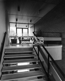
Photograph, Hugh Fisher, Eltham - Interior staircase in Shire Office leading to Reception area, c.1965, 1965
... in the new Shire of Eltham Office at 856 Main Road, Eltham... in the new Shire of Eltham Office at 856 Main Road, Eltham This photo ...View of interior staircase leading to the reception area in the new Shire of Eltham Office at 856 Main Road, ElthamThis photo forms part of a collection of photographs gathered by the Shire of Eltham for their centenary project book, "Pioneers and Painters: 100 years of the Shire of Eltham" by Alan Marshall (1971). The collection of over 500 images is held in partnership between Eltham District Historical Society and Yarra Plenty Regional Library (Eltham Library) and is now formally known as 'The Shire of Eltham Pioneers Photograph Collection.' It is significant in being the first community sourced collection representing the places and people of the Shire's first one hundred years.Digital imagesepp, shire of eltham pioneers photograph collection, eltham, eltham shire office -
 Eltham District Historical Society Inc
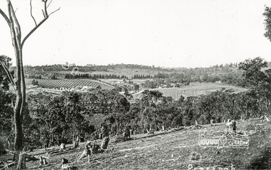
Photograph, Tom Prior, Clearing land at Research
... Main Road is in the distance with the aqueduct following... melbourne Main Road is in the distance with the aqueduct following ...Main Road is in the distance with the aqueduct following the pine trees at top of photo. Doney's store is visible near the road.The Reynolds family were early settlers in Research. The Reynolds/ Prior collection of photographs were taken by Tom Prior, the maternal uncle of Ivy Reynolds, around 1900 and the 60 photos in the album give a fine overview of many of the landmarks of Research and Eltham over 100 years ago. lvy lived in the family home for many years at 106 Thompson Cres Research. Ivy's father, Ernst Richard Reynolds and grandfather, Richard Reynolds, lived at the same address. Ivy's father Richard worked for Mr. Trail on his property in Research. Reynolds Road is named after the family. Mr Tom Prior (wife Eva) worked at the Melbourne zoo. He was very innovative and made his own camera, using the black cloth hood to exclude the light. The photographs are a reminder of the rural nature of Research and Eltham and its rich heritage. Black and white photograph mounted in an album, the Reynolds/Prior Photograph Collection, this being one of 53 reproduced black and white images of early Eltham.The Reynolds/Prior Photograph Collection, Presented to the Eltham District Historical Society, 14 June 2006 by Ross McDonald. A second copy was also presented to the Andrew Ross Museum, Kangaroo Groundreynolds prior collection, research (vic.) -
 Eltham District Historical Society Inc
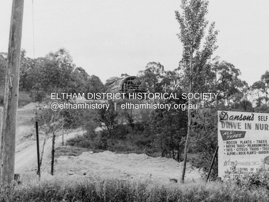
Photograph, Barry Philp, Eltham Barrel under construction, 1968
... View from Main Road looking up at the Eltham Barrel under... melbourne View from Main Road looking up at the Eltham Barrel under ...View from Main Road looking up at the Eltham Barrel under constrcutrion. Note sign for Danson's (nursery) Gardens.research (vic.), building construction, danson's gardens, eltham barrel -
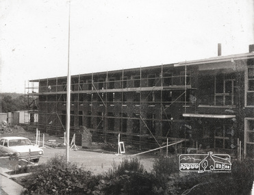 Eltham District Historical Society Inc
Photograph, Completing the south wing of Eltham Shire Offices for Library and Planning Departments, 1971
... for Library and Planning Departments, Main road, Eltham. Building... for Library and Planning Departments, Main road, Eltham. Building ...Completing the south wing of Eltham Shire Offices for Library and Planning Departments, Main road, Eltham. Building demolished 1990s.1 photographBack: "Shire Office extensions 1971" eltham, shire of eltham, eltham library, building, planning department -
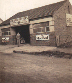 Emerald Museum & Nobelius Heritage Park
Photograph, Emerald Motors, circa 1930's - 40's
... (the Beaconsfield Road) and Main Road. ...) , cnr. Kilvington Drive (the Beaconsfield Road) and Main Road ...Sherriff's Garage started in the Blacksmith's shop (originally Stapletons Blacksmith) , cnr. Kilvington Drive (the Beaconsfield Road) and Main Road. Early history of the commercial district of EmeraldSmall sepia photograph depicting Emerald Motors with (possibly) owner Herbie Sherriff standing out front of businessNo inscriptions, but Kodak manufacturing mark on backemerald motors, herbie sherriff, mobiloil signage -
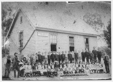
 Ballarat Heritage Services
Photograph - Black and White, Yandoit Hill State School No. 691, c1919
... . When it closed it was moved to the corner of Main Road... Gervasoni. When it closed it was moved to the corner of Main Road ...The land for this school was donated by Carlo Gervasoni. When it closed it was moved to the corner of Main Road and Seventh Street, Hepburn Springs.A number of adults, and students of Yandoit Hill State School, stand in front of the playground shed. One man is in an AIF uniform, and another has a slouch hat on. yandoit creek, yandoit hills, education -
 Ballarat Heritage Services
Photograph - Black and White, Yandoit Hill State School No. 691
... . When it closed it was moved to the corner of Main Road... Gervasoni. When it closed it was moved to the corner of Main Road ...The land for this school was donated by Carlo Gervasoni. When it closed it was moved to the corner of Main Road and Seventh Street, Hepburn Springs. Black and white photograph of three men standing either side of a number of school children of Yandoit Hill State School. yandoit, yandoit hills, yandoit creek, yandoit hill state school, gervasoni, hepburn springs -
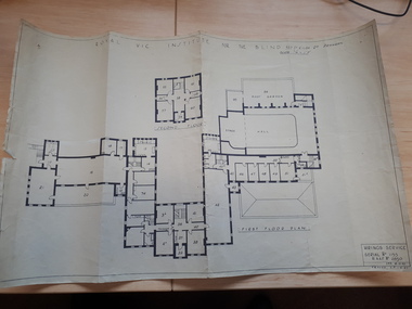 Vision Australia
Plan - Image, Royal Vic Institute for the Blind Hirings Service, 18/12/1943
... 1 architectural plan of St Kilda Road main building... RAAF 1 architectural plan of St Kilda Road main building Royal ...Plan of the first and second floors of the main building at 557 St Kilda Road, created by the RAAF during it's occupation of the same between 1942-1944.1 architectural plan of St Kilda Road main buildingroyal victorian institute for the blind, plans, raaf -
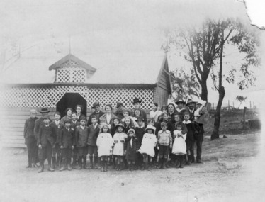
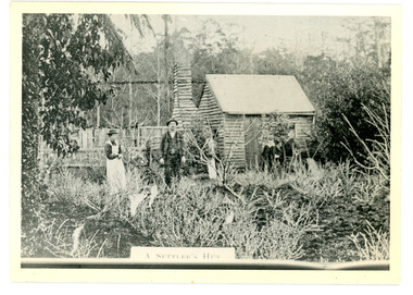 Mt Dandenong & District Historical Society Inc.
Photograph
... Road then Main Road. This was later the kitchen... Keogh's hut on Falls Road then Main Road. This was later ...The Keoghs took up Lot 7 in the Village Settlement in 1905. John Keogh was a big Irishman and cleared many of the giant trees on his Lot 7. They had little water for their crops so grew gooseberries and red currants rather than the more valuable strawberries. Mrs Keogh (nee Cleary) inherited money in 1906 and they built a new weatherboard house. The original bush hut remained as the kitchen. Son James (Jimmie) married Mary Walsh, a teacher at the local school. Jimmie built the small shop on the triangle of land cut off when the CRB road went through. Jimmie and his wife left the district when he joined Victoria Police. Jimmie came back to the area and finally sold the land of Lot 7 to Rimington's Nurseries. He moved his family to Kilsyth. In 1939 the shop was moved across the road to be used as an office by the road builders. It burned down that year.Black and white photograph of a man, woman and young male standing outside a wooden hut. There are crop remnants in the foreground and a wooden paling fence behind the hut. A label on the front reads A SETTLER'S HUT. Reverse of photograph has handwritten description by John Lundy-Clarke.Front: A SETTLER'S HUT Reverse: 1905 Keogh's hut on Falls Road then Main Road. This was later the kitchen of their extended home as described in the narrative "Mountain of Struggle". The figures are - Mrs Keogh. John Keogh settler. Son James Keogh.keogh, john keogh, james keogh, jimmie keogh, mary walsh, cleary, shop, store, gooseberries, rimington's nursery -
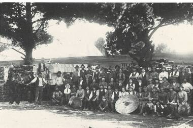 Buninyong & District Historical Society
Photograph - Photograph of original photo of Howard's Buninyong Box Factory, Derek Leather, Howard's Buninyong Box Factory, marking opening of branch rail line across Learmonth St. 1922. Employees gathered for photo, August 1995
... and other products. A railway line crossed the Main Road... products. A railway line crossed the Main Road to the factory which ...Buninyong Industrial historyB/W photo of original sepia phot workers lined up at Howard's Buninyong Box Factory, marking opening of spur rail line across Learmonth St. in 1922."The sawmill where the boxes were made for the Butter and other products. A railway line crossed the Main Road to the factory which was on the land below the Watkin's house (once the Railway Hotel, the brick house on the side of Larmonth St. hill.)box factory, learmonth st., railway spur -
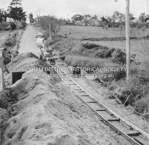 Eltham District Historical Society Inc
Album - Photograph, J.A. McDonald, Eltham-Greensborough Road, July 1956
... looking to Main Road View looking east up Bridge Street to Main... looking to Main Road View looking east up Bridge Street to Main ...Diamond Creek Bridge (Bridge Street Bridge) General view looking to Main Road View looking east up Bridge Street to Main Road prior to widening. The Eltham Obelisk is located at the top of the hill on the left but was relocated to the Eltham RSL front garden as a reesult of road widening works and improvements to the intersection. On the immediate right is the present-day Eltham Rugby Union ovalRecord of various Shire of Eltham infrastructure works undertaken during the period of 1952-1962 involving bridge and road reconstruction projects, sometimes with Eltham Shire Council Project Reference numbers quoted. It was during this period that a number of significant improvements were made to roads and new bridges constructed within the shire that remain in place as of present day (2022). In many situations, the photos provide a tangible visible record of infrastructure that existed throughout the early days of the Shire. The album was put together by or under the direction of the Shire Engineer, J.A. McDonald.infrastructure, road construction, shire of eltham, bridge construction, bridge street bridge, eltham, eltham-greensborough road, 1956-07 -
 Eltham District Historical Society Inc
Scrapbook Page, New Railway Line: Eltham to Hurst's Bridge; The Weekly Times, 24 Feb 1912, p27, 1912
... are 1. A peep on the road, nearing Research. 2. The Main Road... are 1. A peep on the road, nearing Research. 2. The Main Road ...Pages from a scrapbook belonging to Heather Jenkins (nee Cone) who lived as a child in the Police Residence at 728 Main Road, Eltham from 1911 to the early 1920s. Images featured are 1. A peep on the road, nearing Research. 2. The Main Road at Eltham (opposite Railway Station). 3. A part of the new railway line. 4. The mail coach leaving for Kangaroo Ground.Heather McKnight Jenkins (nee Cone) was born 1911, possibly at the Eltham Police Residence and spent her childhood growing up in the Police Residence. Heather was the daughter of John Thomas Cone, Police Constable, and Charlotte Helena Cone (nee Black) who had married in 1906. Constable Cone was transferred to Eltham Police Station from Lauriston (near Kyneton) in May 1911. He retired from the force around September 1922 most likely as a result of significant health concerns experienced earlier that year from 22 April when he was hospitalised. He died 5 October 1922 at Maria Street at age 60 leaving behind a widow and two daughters; his son having pre-deceased him as a result of effects of the war. He is buried in Melbourne General Cemetery . In his probate it states that he owned a piece of land 200 links frontage to Maria Street and a depth of 241 links. It is believed that this is the land opposite the Police Station which Heather Jenkins referred to as being owned by her father and where he agisted the Police horses. Heather, her sister and mother Charlotte remained in Eltham until at least the 1924 Electoral Roll where Charlotte was listed as Home Duties however by 1925 she was listed at 229 Glenferrie Road, Malvern, occupation, Registrar of Births. In the 1934 (and 1936) Electoral Roll, Heather was a Clerk and her mother Charlotte was the Registrar of Births. in 1952 following her mother’s death she made application for Grant of Probate. Heather remains listed in the 1954 Electoral Roll at 13 Ashburton Road under her maiden name Cone however by the 1963 Electoral Roll she is listed at the same address as Heather McKnight Jenkins long with James Gardiner Jenkins. Neither appear listed in the 1958 Electoral Roll. James Gardiner Jenkins (1892-1975) first wife was Fanny Davison Carrucan (1899-1929), daughter of Denis Carrucan and Jane (nee McAleese). They married in 1925. Fanny died 11 November 1929. In the 1934 Electoral Roll he remained listed at John Street, Eltham, Railway Employee however by 1935 Electoral Roll, James Gardiner Jenkins, Railway Employee, was listed at 229 Glenferrie Road, Malvern and he remained living with Charlotte and Heather Cone when they moved to 13 Ashburton Road, Glen Iris. One of Constable Cone’s first investigations upon arriving in Eltham was the accidental fatal shooting in the head with a pea rifle by young Francis August Capewell, aged 11, of John Sutcliffe Deegan, 14, in Maria Street near the Railway. Constable Cone’s replacement was Constable William Charles Sargeant who commenced in charge of the Eltham Police Station from Thursday, 10 August 1922. Constable William Charles Sargeant, and his wife Elizabeth Agnes Sargeant were based at the Eltham Police Station until his transfer to the Police Station in Burwood Road, Hawthorn. He retired at Hawthorn Police Station in 1931, described by Hawthorn Council in 1927 as in a disgraceful condition and unfit for human habitation (Kathryn Griffin family tree – Ancestry) whereupon they moved to 28 Saunders Street, Coburg. Elizabeth died 16 July 1936 in Fitzroy. William then moved to 6 Queen Street Coburg in 1936 and then 1 Queen Street in 1942 where he died 7 August 1944. He is buried at Fawkner Cemetery. Large newspaper clipping (half page), very aged and fragile with sticky tape holding it together with 4 images of early Elthameltham, police residence, heather mcknight jenkins (nee cone), constable john thomas cone, charlotte helena cone (nee black) -
 Bayside Gallery - Bayside City Council Art & Heritage Collection
Photograph, Department of Crown Lands and Survey, Victoria, Brighton, Brighton East and Bentleigh, c. 1965-71
... Street and Nepean Highway. The main roads shown include Centre... Highway. The main roads shown include Centre Road at the top ...The Department of Crown Lands and Survey (1857-1983) was responsible for the administration of survey and mapping and the sale, occupation and management of crown land throughout its existence. This aerial photograph shows parts of Brighton, Brighton East and Bentleigh and was taken circa 1965-71.brighton, department of crown lands and survey, aerial photograph, bayside, port phillip bay, map, cartographic material, bentleigh, brighton east, dendy park, dendy street, centre road, nepean highway, south road, football -
 Eltham District Historical Society Inc
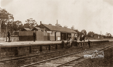
Photograph, Eltham Railway Station, c.1910, 1910c
... Intending passengers were able to walk down from Main Road... melbourne Intending passengers were able to walk down from Main Road ...Intending passengers were able to walk down from Main Road and straight onto the railway platform; there was no rail track on that side then.Copy of sepia photographeltham railway station -
 Eltham District Historical Society Inc
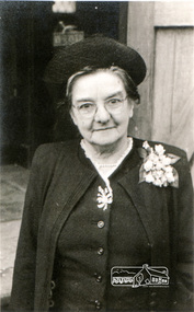
Photograph, Miss Elizabeth Doney
... of the Transfiguration, Research - church moved to the high (east) side of Main...Eltham District Historical Society Inc 728 Main Rd Eltham ...Donated three house blocks for the Church of the Transfiguration, Research - church moved to the high (east) side of Main Road, c.1950Digital scan of photograph - Original Source Copy: St Margaret's Parish Archives. church of england, churches, eltham, st margarets church, church of the transfiguration, elizabeth doney, research (vic.) -
 Eltham District Historical Society Inc
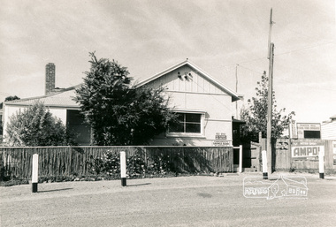
Photograph, Panton Hill Post Office, 27 Apr. 1968
... Former Panton Hill Post Office, Main Road, Panton Hil... melbourne Former Panton Hill Post Office, Main Road, Panton Hil ...Former Panton Hill Post Office, Main Road, Panton Hil with Panton Hill Rural Fire Brigade next doorBlack and white photographpanton hill, post office, ampol service station, panton hill rural fire brigade, rural fire brigade, service station -
 Bayside Gallery - Bayside City Council Art & Heritage Collection
Photograph, Department of Crown Lands and Survey, Victoria, Brighton, Brighton East and Bentleigh, c. 1965-71
... . The main roads shown include Centre Road at the top, Hampton Street... is Brighton Golf Course on Dendy Street. The main roads shown include ...The Department of Crown Lands and Survey (1857-1983) was responsible for the administration of survey and mapping and the sale, occupation and management of crown land throughout its existence. This aerial photograph shows parts of Brighton and Brighton East and was taken circa 1965-71.brighton, department of crown lands and survey, aerial photograph, bayside, port phillip bay, map, cartographic material, brighton east, dendy park, dendy street, centre road, nepean highway, south road, brighton golf course, golf -
 Ringwood and District Historical Society
Photograph, Maroondah Highway West, Ringwood- c1924. Kenworthy Coach Builder & General Smith
... McCaskill. Removed from Main Road & Adelaide St. Cnr Wantirna Rd... Road & Adelaide St. Cnr Wantirna Rd and Main St. Black ...Black and white photograph (1 original, 2 copies)Typed below one copy: "Blacksmiths shop in Maroondah Hwy" Written on back of original copy: "Given to me by Mr Kenworthy- Mr McCaskill. Removed from Main Road & Adelaide St. Cnr Wantirna Rd and Main St. -
 Eltham District Historical Society Inc
Book, Gwen Rodda, Some Roddas: Being a record of the ancestors and descendents of Nicholas Rodda, 1805-1896, 1992
... The Rodda family home, Chun Grove, was located on Main Road...Eltham District Historical Society Inc 728 Main Rd Eltham ...The Rodda family home, Chun Grove, was located on Main Road, Eltham opposite the present BP service station at the corner of Beard Street.Digital file only (74) - Cover and pages 64-136 and explanatory letter of self published book (1992) on loan for scanning by EDHSchun grove, eltham, family history, gwen rodda, nicholas rodda, research (vic.), rodda -
 Greensborough Historical Society
Article, Shire of Eltham, The day a caller fired a bullet in the bank, 1949_
... Bank of Australia agency in Main Road Eltham, now used... at the former Commercial Bank of Australia agency in Main Road Eltham ...A story about an attempted hold up at the former Commercial Bank of Australia agency in Main Road Eltham, now used as an opportunity shop.Photocopy of page from unknown book. Black and white text and line drawing.lindsay spear, stebbing, eltham, commercial bank eltham -
 Halls Gap & Grampians Historical Society
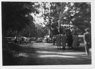
Photograph - B/W, C 1950
... in 1950. This is the main road looking towards the stores from... Camping reserve on Flower Show Day in 1950. This is the main road ...Halls Gap Grampians Camping reserve on Flower Show Day in 1950. This is the main road looking towards the stores from Grampian House.The photo shows a road with trees growing on either side. There are cars parked on either side of the road and people standing and walking along the road. In the centre there are two cars driving along the road towards the camera.events, wildflower show -
 Ballarat Heritage Services
Pamphlet - Photograph - Black and White, Yandoit Hill State School (No 2052)
... to the corner of Main Road and Seventh Street, Hepburn Springs.... to the corner of Main Road and Seventh Street, Hepburn Springs. yandoit ...The land for this school was donated by Carlo Gervasoni. After the closure of the school the building was moved to the corner of Main Road and Seventh Street, Hepburn Springs.A number of students in front of a weatherboard school at Yandoit Hill. yandoit, yandoit hill state school, yandoit hills, yandoit creek, education -
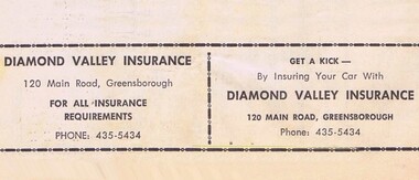 Greensborough Historical Society
Advertisement - Digital Image, Diamond Valley Insurance 1968, 25/08/1968
... Advertisement for Diamond Valley Insurance of 120 Main Road... Insurance of 120 Main Road Greensborough. Copied from a Diamond ...Advertisement for Diamond Valley Insurance of 120 Main Road Greensborough. Copied from a Diamond Valley Football League football record from 1968.Digital copy of advertisement from booklet.diamond valley football league, diamond valley insurance, main street greensborough -
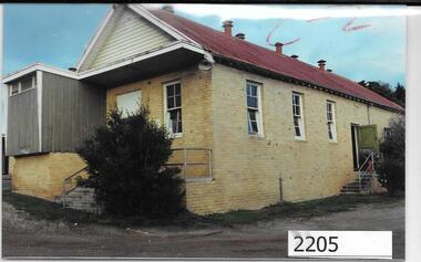 Greensborough Historical Society
Photographs, Unknown, Lower Plenty Hall, 1960s
... way for a carpark, near the corner of Para Road and Main Road... of Para Road and Main Road Lower Plenty. lower plenty hall ...Views of Lower Plenty Hall prior to its demolition to make way for a carpark, near the corner of Para Road and Main Road Lower Plenty.Collection of 3 colour photographslower plenty hall