Showing 11747 items matching "palmyro-island"
-
 Lakes Entrance Historical Society
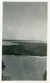
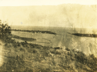
Photograph - Rigby Island, 1950c
Black and white photograph of view from Kalimna across Rigby Island to back lakes near Lakes Entrance, Victoriaislands, waterways, topography -
 Lakes Entrance Historical Society
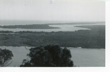
Photograph - Rigby Island, 1950c
Two other copies 6 x 9 (one - slightly different view)Small format photograph of view from Kalimna across Rigby Island to back lakes near Lakes Entrance, Victoriaislands, waterways, topography -
 Lakes Entrance Historical Society
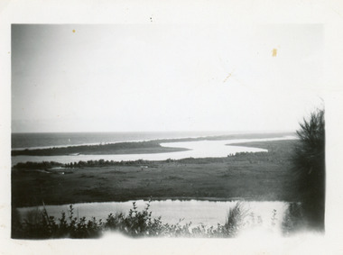
Photograph - Rigby Island, 1950c
Two other copies 6 x 9 (one - slightly different view)Small format photograph of view from Kalimna across Rigby Island to back lakes near Lakes Entrance, Victoriaislands, waterways, topography -
 Lakes Entrance Historical Society
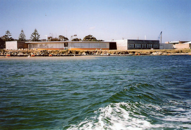
Photograph - Seamac, 2008
Date made August 2008Colour photograph of the educational facility Seamec, on Bullock Island, taken from a boat on Cunninghame Arm. Lakes Entrance Victoria buildings, education -
 Lakes Entrance Historical Society
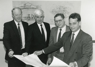
Photograph - Bullock Island, Lakes Post Newspaper, 1991
Date made September 1991Black and white photograph of signatories to the Major Projects Unit - Bullock Island agreement, September 1991, Lakes Entrance, Victoria.islands, commercial development, people -
 Whitehorse Historical Society Inc.
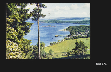
Postcard - Printed postcard, Unknown
Postcard sent by Hilda and Arthur to Mrs C. Caldwell.Postcard sent from Loch Lomond View across the Loch Village of Luss on Western Shore Some wooded IslandsHandwritten messagepostcard, luss village, scotland, loch lomond -
 Lakes Entrance Historical Society
Photograph - View from Kalimna Lookout, 1/01/2025 12:00:00 AM
Sepia toned snapshot of view from Kalimna lookout over the entrance and end of Bullock Island Lakes Entrance Victoriawaterways, islands, topography -
 Flagstaff Hill Maritime Museum and Village
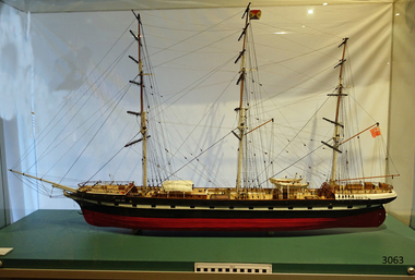
Craft - Ship Model, Loch Ard, 1978
This model of the sailing ship Loch Ard, made by David Lumsden, was commissioned by Flagstaff Hill Maritime Village for the Loch Ard Centenary Commemoration in 1978. The Loch Ard was bound for Melbourne in 1878 loaded with passengers and cargo when it ran into a rocky reef at the base of Mutton Bird Island, near Port Campbell. Of the 54 crew members and passengers on board, only two survived: an apprentice, Tom Pearce and a young woman passenger, Eva Carmichael, who lost all of her family in the tragedy.This model ship is significant as an accurate depiction of the Heritage Listed Loch Ard ship.Ship model, of the heritage listed sailing ship Loch Ard, wrecked in 1878. Plaque engraved "The Loch Ard, Launched 8th November 1873 Clyde Scotland. Wrecked: 1st June 1878 off Mutton Bird Island Victoria Australia. Yet another victim of the fearful Shipwreck Coast"flagstaff hill, warrnambool, shipwrecked coast, flagstaff hill maritime museum, maritime museum, shipwreck coast, flagstaff hill maritime village, great ocean road, ship model loch ard, sailing ship, david lumsden, loch ard centenary 1978, loch ard, tall ship -
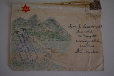 Wangaratta RSL Sub Branch
Work on paper - Envelope Art
Sent to Mrs M MacDonald "Monald" 32 Grey Street Wangaratta Victoria Australia from V129537 ACI Gilbert A V Group 436 RAAF Flinders Island during World War 2 Victoria's 2/24th Infantry Battalion was raised in Wangaratta in July 1940. They were welcomed with open arms by the local community as they rapidly built up their numbers. The people of Wangaratta adopted the Battalion and they became known as "Wangaratta's Own" because of the time the battalion spent in the town during its formative period prior to deployment overseas. Many of the soldiers maintained life long friendships with the people of Wangaratta. Even though the Battation was disbanded in 1946 members and their families return each year, in November, for a commemorative service at the 2/24th Battalion Memorial Wall at the Wangaratta Cemetery.Cream paper envelope with coloured drawing of path leading to three mountains.top left corner - Air Mail/ACF in red star right top corner - postage stamp left side - AIF censor stamp right side - Mrs M Mac Donald "Monald" 32 Grey Street Wangaratta Victoria Australia rear - V129537 ACI Gilbert A V Group 436 RAAF Flinders Islandenvelope art, ww2, aci gilbert a v -
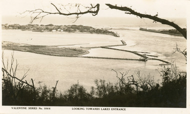 Lakes Entrance Historical Society
Postcard - Bullock Island
Black and white postcard of west end of Bullock Island, showing rock groynes around island, wooden entrance piers in entrance to Gippsland Lakes from Bass Strait, sand dunes showing New Works houses and sheds. A tree branch across top and foreground shrubbery. Lakes Entrance VictoriaLooking towards Lakes Entrance (on front)islands, waterways, room display -
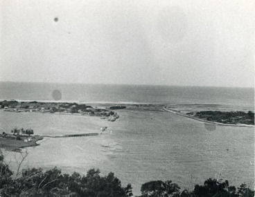 Lakes Entrance Historical Society
Photograph - The Entrance, 1924c
Black and white photograph showing view from Jemmys Point of the entrance, with wooden piers, PWD houses and works buildings at New Works. West end of Bullock Island on left side of photo, bathing boxes and some trees on island, some rock groyne work at the entrance. Lakes Entrance Victoriapiers, islands, houses -
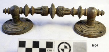 Flagstaff Hill Maritime Museum and Village
Handle, c. 1859
This brass handle was found on Sea Elephant Bay beach in King Island, Tasmania, in 1913. The donor identified it as being from the wreck of the Newfield. It would could have been part of the fittings or amongst the cargo on the ship. ABOUT THE "NEWFIELD" The Newfield was a three-masted iron and steel barque, built in Dundee, Scotland, in 1889 by Alexander Stephen and Sons. It was owned by the Newfield Ship Company in 1890 and later that year It was registered in Liverpool to owners Brownells and Co. The Newfield left Sharpness, Scotland, on 28th May 1892 with a crew of 25 under the command of Captain George Scott and on 1st June left Liverpool. She was bound for Brisbane, Australia, with a cargo of 1850 tons of fine rock salt, the main export product of Sharpness. At about 9pm on 28th August 1892, in heavy weather, Captain Scott sighted, between heavy squalls, the Cape Otway light on the mainland of Victoria but, due to a navigational error (the ship’s chronometers were wrong), he assumed it to be the Cape Wickham light on King Island, some 40 miles south. He altered his course to the north, expecting to enter Bass Strait. The ship was now heading straight for the south west Victorian coast and at about 1:30am ran aground on a reef about 100 yards from shore and one mile east of Curdie’s Inlet, Peterborough. The ship struck heavily three times before grounding on an inner shoal with 6 feet of water in the holds. Rough sea made the job of launching lifeboats very difficult. The first two lifeboats launched by the crew were smashed against the side of the ship and some men were crushed or swept away. The third lifeboat brought eight men to shore. It capsized when the crew tried to return it to the ship for further rescue The Port Campbell rocket crew arrived and fired four rocket lines, none of which connected with the ship. A local man, Peter Carmody, volunteered to swim one mile to the ship with a line to guide the fourth and final lifeboat safely to shore. Seventeen men survived the shipwreck but the captain and eight of his crew perished. One of the men, apprentice William McLeod, was rescued by local woman Margaret E. MacKenzie. The Newfield remained upright on the reef with sails set for a considerable time as the wind slowly ripped the canvas to shreds and the sea battered the hull to pieces. The Marine Board inquiry found the wreck was caused by a "one man style of navigation" and that the Captain had not heeded the advice of his crew. According to Jack Loney ‘… when the drama was over . . the Newfield was deserted except for the Captain’s dog and two pigs.’ Flagstaff Hill Maritime Museum has several artefacts that have been salvaged from the wreck. A report from SHP documented the following in regards to the Newfield collection: Flagstaff Hill’s collection of artefacts from the Newfield is of historical and archaeological significance at a State level, because of its association with the shipwreck, which is on the Victorian Heritage Register. The collection is significant because of its relationship between the objects. The Newfield collection is archaeologically significant as it is the remains of an international cargo ship. The Newfield collection is historically significant for representing aspects of Victoria’s shipping history and its potential to interpret sub-theme 1.5 (Living with natural processes). The collection is also historically significant for its association with the shipwreck. The Newfield collection meets the following criteria for assessment: Criteria A: Importance to the course, or pattern, of Victoria’s cultural history Criteria B: Possession of uncommon, rare or endangered aspects of Victoria’s cultural history Criteria C: Potential to yield information that will contribute to an understanding of Victoria’s cultural history Ornate brass handle, round plates each end, each with 4 round fixing holes. Found washed up on Sea Elephant Bay beach, King Island 1913, identified by donor as being from the wreck of the Newfield.flagstaff hill, warrnambool, shipwrecked-coast, flagstaff-hill, flagstaff-hill-maritime-museum, maritime-museum, barque newfield, shipwreck-coast, flagstaff-hill-maritime-village, ornate handle, sailing ship fitting, sea elephant bay, king island -
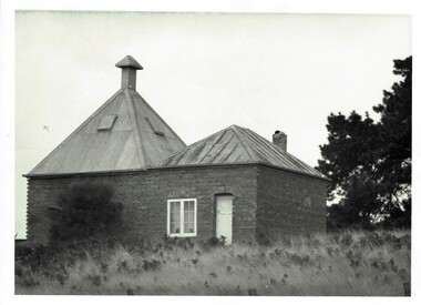 Phillip Island and District Historical Society Inc.
Photograph, Richardson's chicory kiln 1077-01
In 1878, the first chicory kiln was built by Mr. John and Solomon West, in Thompson Avenue, Cowes, near the Esplanade and the second kiln was built in 1880 by Mr Joseph Richardson.HistoricalLarge black & white photo of a brick chicory kiln with a metal roof,door and window. In a paddock with large trees nearby.2nd chicory kiln on Phillip Island, now turned into a holiday house.chicory, chicory kilns, joseph richardson, -
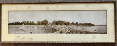 Phillip Island and District Historical Society Inc.
Photograph, Framed Panorama Cowes Jetty & Booklet, Prior to 1938
Neil Robinson believes the photo was taken prior to 1938, based on the existence of a small shed on the east side of the jetty.HistoricalFramed Panorama of Cowes Jetty taken from the jetty showing the jetty shed, Isle of Wight hotel and other Cowes buildings. Photo is lightly coloured. Plus Booklet - Research Data of Buildings etc. in PanoramaCowes Phillip Island Victoria. The Valentine Publishing CO. PTY.LTD. Melbournepanorama cowes jetty, the isle of wight hotel cowes phillip island, cowes sea baths, bayview house, neil robinson, maggie robinson, george cox -
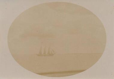 Phillip Island and District Historical Society Inc.
Photograph, 1850's
From a collection of photographs donated by Mrs W RankineImage of a Three masted Sailing Ship"Taken by Mrs H Smith Probably the "Theroult" Story in Island book"sailing ships, sailing ship theroult -
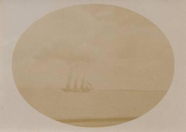 Phillip Island and District Historical Society Inc.
Photograph, Early 1900's
Photograph from a collection of photos donated by Mrs W Rankine.Photograph of a Three Masted Sailing Ship"Taken by Mrs A. H. Smith probably the "Theroult" - story in Island Book"sailing ships, mrs w rankine -
 Phillip Island and District Historical Society Inc.
Book, HYRST, H.W.G, Adventures in the Arctic regions : romantic incidents & perils of travel, sport and exploration around the Poles, 1910
Stamped 'Ventnor Free Library', 'S.S.3895 Ventnor Phillip Island'. -
Phillip Island and District Historical Society Inc.
Book, WHITE, Joseph, One hundred years of history, 1974
Stamped 'Phillip Island & District Historical Society'. 'Donated by Shire of Phillip Is.'bass, victoria, shire, history, phillip island, woolamai -
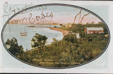 Phillip Island and District Historical Society Inc.
Photograph - Post Card, Early 1900's
One of 16 photographs and postcards donated by Mary KarneyColour postcard of Newhaven with pier and San Remo in the background."Greetings from Cowes" "Phillip Island Newhaven, San Remo in distance."newhaven jetty, newhaven beach, phillip island beaches, mary karney -
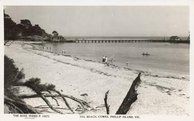 Phillip Island and District Historical Society Inc.
Photograph - Post Card, Unknown
One of 11 photographs left in the museum for the Society by an anonymous donor.Black & White postcard of the Cowes beach with the Cowes Jetty in the background. Shed on the end of the pier and the Cowes Jetty Shed at the beginning of the Jetty. People at the water's edge with two boats in the water.The Rose Series P 10073. The Beach, Cowes, Phillip Island, Vic.cowes beach phillip island, cowes jetty, cowes jetty shed, phillip island beaches -
Phillip Island and District Historical Society Inc.
Book, Education Dept. (Victoria), Victorian readers : seventh book, 1940
Stamped 'S.S. 3895, Ventnor, Phillip Island'. Inscribed 'John Youngman'. -
Phillip Island and District Historical Society Inc.
Book, Hutchinson & Co, wonders of the world : a popular and authentic account of the marvels of nature and of man as they exist today / by eminent travellers Sir Harry Johnston [et al]
Stamped 'A. Newman, Newhaven'. Stamped 'Phillip Island & District Historical Society'. -
Phillip Island and District Historical Society Inc.
Photograph, ?
Part of collection of Photographs donated to the Museum by The Family of late Mr. Jack Jenner (1977).Sepia Postcard - Valentine Series - Aerial view of Cowes & Pier.View of Cowes, Phillip Island, from the air. Valentine Series No. 1616.local history, photography, photographs, slides, film, view cowes, sepia photograph, jack jenner, aerial view cowes, valentine series -
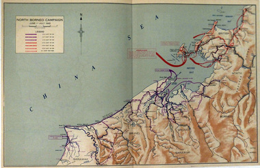 Warrnambool RSL Sub Branch
Map, NORTH BORNEO CAMPAIGN. June-July 1945
Paper. Colour. Different coloured arrows show troop movements in Brunei and Labuan Islandmap ww2. north borneo -
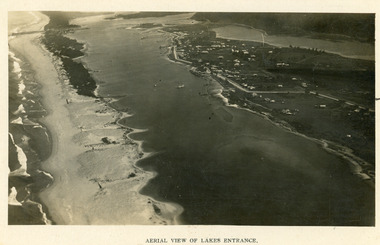 Lakes Entrance Historical Society
Photograph - Lakes Entrance, 1923c
Two copies 16.5 x 25.5 very darkBlack and white photograph showing early aerial view of township of Lakes Entrance, photo shows highway going along Myer Street and along Roadknight Street, no shops in Myer Street appears to be no foot bridge, therefore taken prior to 1937, sparce vegetation on foreground dunes, four barriers built on dunes to stop erosion through sand, two masted sailing boat in lake. Bullock Island in distance appears very small, Snake Island of Rigby Island in centre distance. Lakes Entrance VictoriaAerial View of Lakes Entrancewaterways, coast, aerial photograph, islands, township -
 Camberwell Girls Grammar School
Digital images, Dean Image Collection, 1954-1958
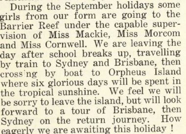
Sixteen black and white images recording the holiday to Orpheus Island in 1955 including a copy of the menu from the Orpheus Island Lodge restaurant. Also included are images of School sporting teams and groups of girls in the School grounds and an undated reunion of the 1958 leavers. Extract from the Marcian is included to provide background on the trip.Images of the back of some photos included with names and dates -
 Lakes Entrance Historical Society
Photograph - The Entrance, 1995c
Second colour copy as 01601-1 portrait size 15 x 10Colour photograph of the entrance from Bass Strait to the Gippsland Lakes. It shows buildings on Bullock Island including Peck's factory. Western end of Bullock Island and area below Jemmys Point, both made during dredging operations over many years. Two fishing boats in entrance. Lakes Entrance Victoria room display, waterways, topography -
 Flagstaff Hill Maritime Museum and Village
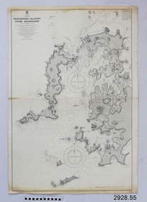
Document - Navigation Chart, Pescadores Islands Inner Anchorage
British Admiralty Navigation Chart - China - Formosa Strait - Pescadores Islands Inner Anchorage, from a French Goverment Survey 1886warrnambool, shipwrecked-coast, flagstaff-hill, flagstaff-hill-maritime-museum, maritime-museum, shipwreck-coast, flagstaff-hill-maritime-village, shipwrecked-artefact, navigation chart, british admiralty navigation chart, british admiralty, pescadores islands inner anchorage -
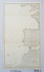
 Flagstaff Hill Maritime Museum and Village
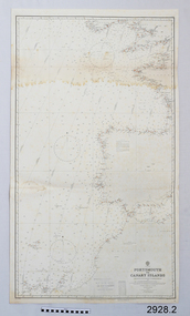
Document - Navigation Chart, Portsmouth to Canary Islands, CA. 1928
Navigation charts are drawn by professional hydrographers and describe the geography of land and water, enabling a water based navigator on board vessels such as ships to safely negotiate between ports locally and around the world. They are drawn to a particular standard with common symbols noting landmarks. The charts are used in conjunction with other navigational instruments and tools to calculate the vessel’s exact location and a safe route to its destination.The set of charts and their chart are of significance as examples of equipment and documents used to navigate the oceans of the world, particularly to Australia. Migration to Australia is an important part of this country's history.British Admiralty Navigation Chart - Portsmouth to Canary Islands - printed on rectangular white paper. Published in London by the British Admiralty in 1928.warrnambool, shipwreck coast, flagstaff hill, flagstaff hill maritime museum, flagstaff hill maritime village, chart, map, navigate, navigation, location, vessel, 1928, british admiralty, hydrographer, geography, admiralty chart, portsmouth, canary islands -
 Flagstaff Hill Maritime Museum and Village
Document - Navigation Chart, Portsmouth to Canary Islands, Ca. 1928
This is an Official British Admiralty Navigation Chart, one of a set of 65 charts donated together with a wooden chart case. It was published and printed in London in 1928 by the British Admiralty. Navigation charts are drawn by professional hydrographers and describe the geography of land and water, enabling a water based navigator on board vessels such as ships to safely negotiate between ports locally and around the world. They are drawn to a particular standard with common symbols noting landmarks. The charts are used in conjunction with other navigational instruments and tools to calculate the vessel’s exact location and a safe route to its destination.The set of charts and their chart are of significance as examples of equipment and documents used to navigate the oceans of the world, particularly to Australia. Migration to Australia is an important part of this country's history.British Admiralty Navigation Chart - Portsmouth to Canary Islands - printed on rectangular white paper. Published in London by the British Admiralty in 1928.warrnambool, shipwreck coast, flagstaff hill, flagstaff hill maritime museum, flagstaff hill maritime village, chart, map, navigate, navigation, location, vessel, 1928, british admiralty, hydrographer, geography, admiralty chart, portsmouth, canary islands