Showing 14064 items
matching properties
-
 Whitehorse Historical Society Inc.
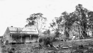
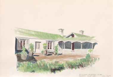
Photograph, Schwerkolt Property 3rd house with Smokehouse, 1917 - 1927
The third ,weatherboard, house was built after the first house was burnt down in the 1905 bushfires. After the property was sold to developers in 1959 this house was burnt down by vandals.Black and white photo of the weatherboard house with verandah on the left of the photo and the stone smokehouse on the right.whalen, rosalie, schwerkolt, arthur, schwerkolt 3rd home -
 Whitehorse Historical Society Inc.
Document - Letter, Mary Elizabeth Jack, Letter from Mary Jack to Charles Schwerkolt, Oct 1962, Oct 1962
Colour photocopies, A4, covering letter (3 pgs) and an envelope (i pg).non-fictionjack mary elizabeth, schwerkolt charles clarence victor -
 Whitehorse Historical Society Inc.
Photograph, Arthur & Janet HOOKE
Arthur & Janet Hooke deeded their property Wandinong' in Canterbury Road to the Nunawading Council in 1973. In 2008 two of their grandchildren presented Janet's bicycle to the Whitehorse Historical Society.Black & White photo of Arthur & Janet Hooke with their bicycles in 1968 at Noosa, Queenslandhooke arthur, hooke janet, wandinong sanctuary -
 City of Ballarat Libraries
Photograph - Card Box Photographs, Site of St Martins in the Pine circa 1880
Pictured are the Fanning family who were toll-keepers. The property on Geelong Road is now St Martins in the Pines which was gifted to the Sisters of Mercy by Alice Fanning.st martins in the pines, alice fanning, sisters of mercy, building, vehicle, persons, private dwelling -
 Maldon Vintage Machinery Museum Inc
Steam Engine, C 1849
Thought to be the world's only working example of this engine. Used for driving overhead shafts in workshops, sawmills etc. Restored by members of the MVMM. Found at the Demsters property Shelbourne. Thought to be the only one of its kind in the world.Horizontal steam engine driving a flat belt pulley. Pulley shaft at right angles to engine shaft also carries a large flywheel. A mechanical oiler mounted on the engine base is activated by the engine valve shaft. Engine cylinder and valve housing painted dark green. Engine base, pulley and flywheel painted maroon. Oiler painted mid green.On engine valve box cover - Light green cast iron oval plate with "Cornelius Pettet / Engineer / Edinburgh" Brass plate on oiler - "Delvac Mechanical Lubricator / Design No 18376 / Made for and supplied by / Vacuum Oil Company Pty. Ltd. / Australia"machinery; engines; steam power source -
 Port Fairy Historical Society Museum and Archives
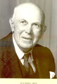
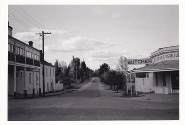
Photograph, Cr W Riddell Shire of Belfast president 1914-15
Councillor Riddell’s property on Riddells Lane, Kirkstall was mainly used for grazing. He was actively associated with all types of sport and was a judge at Kirkstall and Koroit race meetings.Black and white portraitportrait, belfast, president, shire, government, municipal, local-government, kirkstall, riddells lane -
 The Beechworth Burke Museum Research Collection
Card - Index Card, George Tibbits, 2 William Street, Beechworth, 1976
Property - 2 William St (Cnr Loch) - 100' x 250' 12 Oct 1857 - C.Stewart Index Card - Brian Pump and Tony Dugan - Photographers beechworth, george tibbits -
 The Beechworth Burke Museum Research Collection
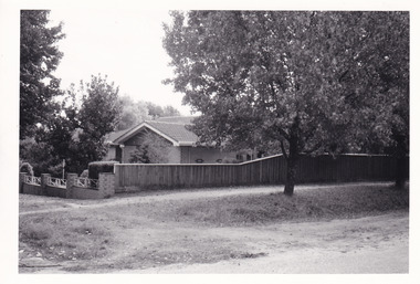
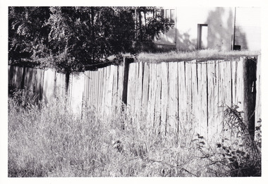
Photograph (Series), George Tibbits, Fences in various streets in Beechworth, 1976
George Tibbits, University of Melbourne. Faculty of Architecture, Building and Town & Regional PlanningIndex system that support the research for Beechworth : historical reconstruction / [by] George Tibbits ... [et al]Arranged by street names of BeechworthEach index card includes: street name and number of property, image of property, allotment and section number, property owners and dates of ownership, description of the property according to rate records, property floor plan with dimensions.beechworth, george tibbitsbeechworth, george tibbits -
 The Beechworth Burke Museum Research Collection
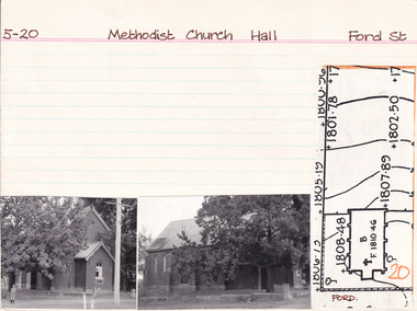
Card - Index Card, George Tibbits, Ford Street, Beechworth, 1976
Property - Methodist Church Hall - Section 5, Town Allotment 5 Ownership details and history Architectural Index Card - Brian Pump and Tony Dugan - Photographers beechworth, george tibbits -
 The Beechworth Burke Museum Research Collection
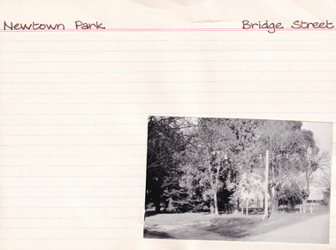
Card (Series) - Index Card, George Tibbits, Bridge Street, Beechworth, 1976
George Tibbits, University of Melbourne. Faculty of Architecture, Building and Town & Regional PlanningIndex system that support the research for Beechworth : historical reconstruction / [by] George Tibbits ... [et al]Arranged by street names of BeechworthEach index card includes: street name and number of property, image of property, allotment and section number, property owners and dates of ownership, description of the property according to rate records, property floor plan with dimensions.beechworth, george tibbitsbeechworth, george tibbits -
 The Beechworth Burke Museum Research Collection
Photograph (Series) - Index Card, George Tibbits, High St, Beechworth, 1976
George Tibbits, University of Melbourne. Faculty of Architecture, Building and Town & Regional PlanningIndex system that support the research for Beechworth : historical reconstruction / [by] George Tibbits ... [et al]Arranged by street names of BeechworthEach index card includes: street name and number of property, image of property, allotment and section number, property owners and dates of ownership, description of the property according to rate records, property floor plan with dimensions.beechworth, george tibbitsbeechworth, george tibbits -
 Melbourne Tram Museum
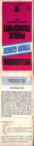
Map, Ministry of Transport, Melbourne Public Transport Map - No. 9, 1979
Map No. 9 - Includes description of tram and bus routes, private bus routes. Has contact details for bookings and lost property etc and how to use the map. Yields information about Melbourne public transport services in 1979Fold out map (27 sections 9 across x 3 deep), "Public Transport Map", coloured of Melbourne's Tram and Bus routes, route numbers, rail lines, detailed for the central part of Melbourne and the outer Metropolitan services.tramways, melbourne, tram services, bus services, railways, travelcard, maps -
Port Melbourne Historical & Preservation Society
Photograph - Former corner shop, 207 Ross Street at Bridge Street, Jan 2002
This heritage property will be developed. Originally it was a mixed business - grocery, greengrocer, milk bar and newsagent. In the 1960s it became a grocery only, before closing down to become a residence. Three colour photographs of the 'Corner shop' 207 Ross Street at Bridge Street, now a residence only. January 2002.built environment -
 Melbourne Tram Museum
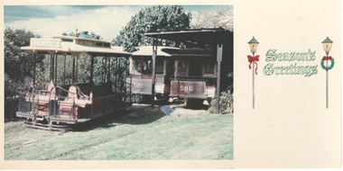
Photograph - Christmas Card - Twentyman cable trams
The card shows the three Melbourne cable cars that were owned by Alf Twentyman at his Northcote property - grip car 436 and cable trailers 290 and 586. Yields information about the Alf Twentyman cable car collection.Colour photo used as Christmas Cardtrams, alf twentyman, tram 586, northcote, tram 436, tram 290, christmas card -
Glen Eira Historical Society
Article - Regent Street, 76, Elsternwick
Two documents about this property: Newspaper article from Home Weekly Residential dated 29/10/2004 gives details of interior features including security, heating and air conditioning. Also 2 newspaper ads with photo and drawing respectively for hand-noted date 22/10/2004 and publication date 24/11/2000 (Property Review Weekly). Additional information from Sands and McDougall editions 1948, 1960 and 1970 gives former residents’ names.regent street, brittain geo f., elsternwick, hocking stuart, real estate agents, duncalfe mavdie -
Glen Eira Historical Society
Document - Shoobra Road, 1, Elsternwick
3 items about this property: Auction details of 1 Shoobra Road: Melbourne Weekly Bayside article of 30/05/2012 and Property Review Weekly dated 25/05/2012 of forthcoming auction. As articles mention the house was 1920’s possibly meaning that original house (Cragie) was demolished: Also include current house features for sale advertisement Research notes from Sands and MacDougall detailing residents in 1910/1913/1923/1942/1948/1960.caulfield, glenhuntly road, elsternwick, pisano max, berry mary a., brown arth e, shoobra road, rushford marshall., jones alfred h., misso n. d, architectural features, cragie, berry herbert, real estate agents, brick houses, house names, ryder sophia, hocking stuart real estate, harper john a, ryde andw., harper jno a -
 Glen Eira Historical Society
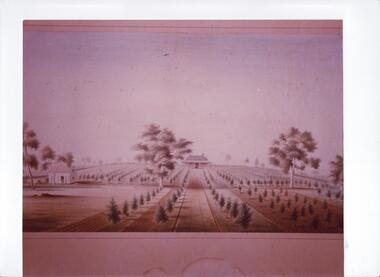
Document - Thomas, George
This file contains three items Hand written report on property of George Thomas in Orrong Road, dated 04/06/1985, author unknown Photocopy of four page contract and conditions of sale for lot 262 county of Burke Parish of Prahran. George Thomas property was sold to George William Taylor, dated 20/10/1881 The original photograph of a water colour painting of home and garden of George Thomas, Orrong Road, Caulfield by W. Tibbits 1876thomas eric f, thomas george, beemery park, orrong road, seymour road, allison road, mullaly j, j. fulton, taylor george william, warrein road, north road, stone adelaide, orrong road t. fulton, business, farmers, farm workers, farms, gardeners, subdivisions, land subdivision, land sales, land prices, land development, land developers -
 Otway Districts Historical Society
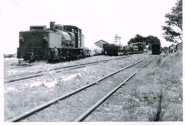
Photograph, R.L. Forster, G41, Beech Forest, 1950, 1950
From 1945 a sawmill, the Calco Mill, was formed to cart sawn timber initially from the Zappelli's property on Denherts Track. The plant was later shifted to Pul's property and, in 1951, finally moved to a new mill in the Beech Forest railway yard. Potato output also rose, around 280 hectares and was shipped exclusively by rail until 1955. The railway was very busy, in fact so busy that potato farmers and especially saw millers started agitating for road transport.G41 locomotive, four NQR loaded wagons, and a louvred van near the Goods Shed. Next line, three loaded and three empty NQR wagons. In the foreground near the station building, a louvred van. A water tank and timber mill in the background. B/Wbeech forest; railways; loco g41; -
 Bayside Gallery - Bayside City Council Art & Heritage Collection
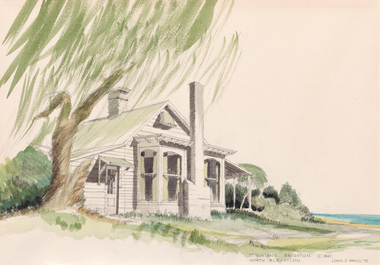
Work on paper - watercolour, John C. Paul, St. Ninian's north elevation c.1841, 1971
Built around 1841, St Ninian’s, located at 10 Miller Street, was one of Brighton’s earliest buildings. It is best known as being the home of merchant shipping agent, politician and former British naval officer, George Ward Cole between the 1840s and 1902. Following the death of George Ward Cole in 1879 and his wife in 1898, their only surviving child, Margaret, sold the property to Sir Thomas Bent, who subdivided the land in the early 1900s. The property was demolished in 1974. John C. Paul, St. Ninian's north elevation c.1841 1971, watercolour, 29.5 x 42.3 cm. Bayside City Council Art and Heritage Collection. Purchased 1974.st ninian's, brighton, historic house, george ward cole, thomas bent -
 Bayside Gallery - Bayside City Council Art & Heritage Collection
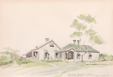
Work on paper - watercolour, John C. Paul, St. Ninian's south elevation c.1841, 1971
Built around 1841, St Ninian’s, located at 10 Miller Street, was one of Brighton’s earliest buildings. It is best known as being the home of merchant shipping agent, politician and former British naval officer, George Ward Cole between the 1840s and 1902. Following the death of George Ward Cole in 1879 and his wife in 1898, their only surviving child, Margaret, sold the property to Sir Thomas Bent, who subdivided the land in the early 1900s. The property was demolished in 1974. John C. Paul, St. Ninian's south elevation c.1841 1971, watercolour, 29.5 x 43 cm. Bayside City Council Art and Heritage Collection. Purchased 1974.st ninian's, brighton, historic house, george ward cole, thomas bent -
 Bayside Gallery - Bayside City Council Art & Heritage Collection
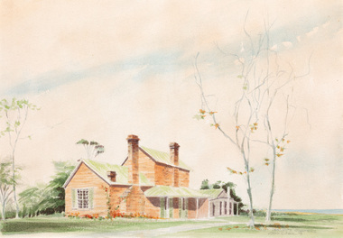
Work on paper - watercolour, John C. Paul, St. Ninian's servants' quarters, 1975
Built around 1841, St Ninian’s, located at 10 Miller Street, was one of Brighton’s earliest buildings. It is best known as being the home of merchant shipping agent, politician and former British naval officer, George Ward Cole between the 1840s and 1902. Following the death of George Ward Cole in 1879 and his wife in 1898, their only surviving child, Margaret, sold the property to Sir Thomas Bent, who subdivided the land in the early 1900s. The property was demolished in 1974. John C. Paul, St. Ninian's servants' quarters 1975, watercolour, 27.5 x 39.6 cm. Bayside City Council Art and Heritage Collectionst ninian's, brighton, historic house, george ward cole, thomas bent, servants' quarters -
 Bayside Gallery - Bayside City Council Art & Heritage Collection
Work on paper - watercolour, John C. Paul, St. Ninian's eastern courtyard c.1841, 1971
Built around 1841, St Ninian’s, located at 10 Miller Street, was one of Brighton’s earliest buildings. It is best known as being the home of merchant shipping agent, politician and former British naval officer, George Ward Cole between the 1840s and 1902. Following the death of George Ward Cole in 1879 and his wife in 1898, their only surviving child, Margaret, sold the property to Sir Thomas Bent, who subdivided the land in the early 1900s. The property was demolished in 1974. John C. Paul, St. Ninian's eastern courtyard c.1841 1971, watercolour, 28.5 x 40.8 cm. Bayside City Council Art and Heritage Collection. Purchased 1974.st ninian's, brighton, historic house, george ward cole, thomas bent, courtyard -
 Sunbury Family History and Heritage Society Inc.
Photograph, 'Glenara' Homestead
'Glenara' is the homestead, which is situated in the Deep Creek valley at Bulla. It was the home of Walter Clark, who moved from NSW to Victoria in 1853 and purchased land on the banks of Deep Creek. Four years later in 1857 his homestead was completed. In the same year Bulla Racing Club held its first annual meet on the property. Later that year, Alister Clark purchased the homestead from the family estate and began developing an extensive rose garden on his property. Alister Clark developed varieties that are adaptable to Australia's climate such as the Lorraine Lee rose and his rose breeding achievements led him to international recognition as a rose breeder of note.A non-digital black and white photograph with a white border of large single story Italianite homestead in a creek valley and surrounded by lightly timbered hillsglenara homestead, bulla bulla, walter clark, alistair clark, roses, rose gardens, deep creek -
 Sunbury Family History and Heritage Society Inc.
Photograph, Ardcloney House
The two storey house is 'Ardcloney. Dr. William Faulkner, formerly from Queensland, had it built for his residence in 1911. The property also included a garage, which accommodated his automobile and accommodation for his chauffeur. Owners in more recent times were Keith Campbell, who previously owned 'Willowbank' in the old Broadmeadows township and Bill Landeroo a former Victorian State MP. The buildings and surrounds have been redeveloped and the property is now the Sunbury Day Care Hospital.'Ardcloney' is one of Sunbury's significant historical properties in the town.A non-digital black and white photograph of a two- storey Californian style mansion in a garden setting. The ground floor is constructed of bricks and the upper storey of timber. The roof is tiled. The image is a copy of an original photograph. ardcloney, dr. william faulkner, sunbury, sunbury day care hospital -
 Warrnambool and District Historical Society Inc.
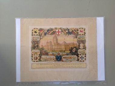
Certificate - Federation Celebration Rolfe invitation, 1901
This invitation to a ‘Conversazione’ to celebrate the Federation of the six colonies in Australia into the six States of Australia in 1901 was sent to the invitees after the event to keep as a souvenir of the occasion. The event was hosted by the Government of Victoria. The certificate was designed by George Brougham Austin, a Melbourne architect and artist employed by the Victorian Department of Public Works. He also designed many of the public decorations displayed in Melbourne during the Federation celebrations. Austin’s original work was lithographed by an artist at Sands and McDougall, Melbourne. This particular invitation was sent to George Rolfe and his wife, Annie. George Rolfe (1836-1919), a tea merchant from Melbourne, began buying blocks of land near the mouth of the Hopkins River in Warrnambool in the 1870s. By the early 1880s he owned 50 acres of land in the town and some nearby farming properties. He used the building on the ]and near the mouth of the Hopkins River as holiday accommodation and called the property, Lyndoch. He improved the property with the additions of stables, jetty, boathouse, bone and chaff sheds, reservoir and windmill and extensive gardens. Rolfe spent most of his later life at Lyndoch. Today the property is the site of an Aged Care facility. This certificate is of considerable importance for two reasons: 1. It is an important and attractive memento of a signal event in the history of Australia – the Federation of the States in 1901. 2. The certificate was an invitation to Mr and Mrs George Rolfe. George Rolfe was a prominent Warrnambool person in the late 19th and early 20th centuries. This is a multi-coloured certificate printed on a cream-coloured card. The certificate has an image of the Exhibition Building surrounded by an ornate border of heraldic shields, portraits of the Duke and Duchess of Cornwall and York, views of the six capital cities of Australia, native flora and fauna, the Royal Crest and the Crest of Australia. The names of the invitees are handwritten in black ink. ‘United Australia 1901 One Flag One Hope One Destiny Australian Commonwealth Celebrations’ ‘The Government of Victoria requests the honor of the presence of Mr & Mrs G. Rolfe at a Conversazione in the Exhibition Building on the Evening of Tuesday 7th May 1901 at 8 p.m.’ george rolfe of lyndoch, warrnambool, federation of australia, history of warrnambool, george rolfe -
 Warrnambool and District Historical Society Inc.
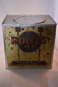
Household, Tea tin, Late 19th century
This tin comes from the Melbourne firm of Rolfe and Co. and would have held tea. Rolfe & Co. was established by George Rolfe (Senior) in 1854 as a wholesale wine, spirit and provisions business. George Rolfe was a member of the Upper House of the Victorian Government from 1860 to 1862 and in 1867. He died in 1871 and his son, also George, succeeded him as the managing director of the business. This George Rolfe (1837-1919) came to Australia with his family in 1849 and lived first in South Australia and then came to Melbourne, joining his father’s business, George Rolfe was a keen farmer and fisherman and after holidaying in Warrnambool for some time, bought, in the early 1870s, the property at the mouth of the Hopkins River which he named Lyndoch after the town in South Australia. He came frequently to Warrnambool. He later extended his farming interests which included the properties of Fairy Hill and Shipley. George Rolfe married Jane Ann Lake in 1891 and the Lyndoch property passed to two of his stepdaughters. Today the Rolfe property is the site of an aged care facility. The business of Rolfe & Co. continued well into the 20th century.This tin is of great interest as a memento of George Rolfe of Lyndoch, Warrnambool and his Melbourne business, Rolfe & Co. George Rolfe was a prominent person in the Warrnambool district in the late 19th and early 20th centuries. This is a metal container, rectangular in shape. It originally held tea. The sides of the tin have painted lettering regarding the contents and the supplier. This paint was originally in yellow, blue and brown tonings. The lid is round and slots into the rounded opening. The tin has been re-painted in a silver colour on the top and inside. The tin, especially the lettering on the sides, is much rusted and in some places the words are illegible. A small hole has been pierced in the top of the tin‘Rolfe’s Tea’ ‘Rolfe & Co. Ltd 300 King Street Melbourne’ rolfe & co, george rolfe senior, george rolfe junior, lyndoch, warrnambool -
 Wodonga & District Historical Society Inc
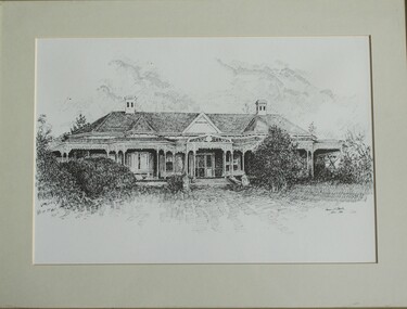
Drawing - Cambourne House, Kevin P. Clark, 1984
Cambourne homestead was built by 1903 for Rebecca S. Carkeek, who purchased the property in Wodonga in 1899. Cambourne is situated on the original Wodonga run which was established in 1836. The township of Belvoir, later renamed as Wodonga. In 1855 the pre-emptive right of 171 acres of the Wodonga run was granted and sold the following year. The allotments on which the five-acre Cambourne property developed, were purchased in 1873 and 1876, coinciding with the opening of the railway from Melbourne. The property was purchased by Rebecca Carkeek in June 1899, wife of William Carkeek, publican of Wodonga and shire councillor. Local architects Gordon and Gordon have been credited with the design of Cambourne. The house at Cambourne was built at some stage between 1900 and 1903 as a large single storey homestead. It was constructed in red brick with corrugated iron roof and encircling verandah. Cambourne is a probable work of architects Gordon and Gordon, it is amongst their best preserved and one of their few surviving buildings in Victoria. Today Cambourne remains on a reduced allotment due to the acquisition of land in 1972 by the Country Roads Board and in 2006 by Vic Roads for road works adjacent to the property.This drawing is significant as a representation of Cambourne in Wodonga. Cambourne is of historical significance due to its links with the early settlement of the district and as an example of closer settlement which occurred in regional centres of the State. Cambourne, Wodonga is also of architectural significance as a largely intact late Victorian style house with elaborate decorative cast iron work and distinctive transverse plan. As a probable work of architects Gordon and Gordon, it is amongst their best preserved and one of their few surviving buildings in Victoria. A framed drawing of historic home, Cambourne in Wodonga. The drawing has been mounted and framed.On bottom right corner" Kevin P. Clark 1984"cambourne wodonga, gordon and gordon architects, historic buildings wodonga, heritage buildings wodonga -
 Surrey Hills Historical Society Collection
Photograph, Grovedale Road Quarry in the 1920s - looking south, c1920
The quarry was part of John Butler Maling's property. He was one of the original settlers of the area and farmed the area between Weybridge Street and Whitehorse Road. Clay was quarried from part of this area and used to make the bricks used in the construction of his home, known as 'Ancyra'. This is still extant at the corner of Weybridge and James Streets. Maling grazed cows and used the quarry as a water source. He was the uncle of John Butler Maling, Mayor of Camberwell. He was married to Kate Conlon in 1882. They had 3 children: Silas Young, Alick and Zillah. Maling was born in c1829 in Shepreth, Cambridgeshire; he died in Surrey Hills on 9 October 1912 and is buried in Box Hill Cemetery - CE-*-0586. Mrs Kate Maling (born c1859 in Co Meath, Ireland) died at the property on 8 March 1921. She is buried in Brighton General Cemetery. Probate was valued at over 10,000 pounds and included other properties in Sandringham, Hawthorn and Macedon. At the time of her death the Surrey Hills property was described as being 23 acres with 2 brick houses, 1 cow, 2 heifers and 40 fowls or chickens. The property was subdivided after her death. The property was subdivided into 110 house blocks in c1923 - see Maling's Estate subdivision flyer on the State Library of Victoria's website. This shows that the Grovedale Park site had been acquired by Camberwell Council by this time. An attached newspaper clipping documents prices realised for a cross-section of blocks. The MMBW map of 1925, also on the SLV website, shows the outline of the clayhole / quarry. The quarry was filled in after several drownings or near drownings and the land is now occupied by a park and playground, known as Grovedale Road Park, maintained by the City of Boroondara. Beckett Park is sited on horizon to the left beyond the trees. This documents the landscape prior to close settlement and is material to early building and farming in the Surrey Hills area.Black and white photo of the quarry between Grovedale Road and James Street taken in the 1920s and looking south. In the foreground is an area of water with reeds in the LH corner. Beyond on the high banks there are single storey houses in the background and (?) some light poles. An object that looks like a tank on posts is in a cutting on the far bank.quarries, grovedale road, james street, clay quarries, farming, kate conlon, kate maling, john butler maling, ancyra -
 Warrnambool and District Historical Society Inc.
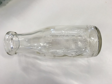
Bottle, Antarctic Ice Milk Bottle, Early /mid 20th century
Antarctic Ice dairy plant was in Kepler St Warrnambool. It sold to Warrnambool Cheese and Butter and Kraft in the 1940’s and was relabeled as Sungold Dairies. They then purchased Kaye Ryan and relocated to Verdon Street.A common item with links to a local manufacturing business.Round bottle with wide neck and thick rim around top. Logo embossed on front of bottle with writing around bottom of bottle as well.Embossed on bottle as follows: This bottle contains milk bottled for sale by Antarctic Ice Products Pty Ltd Warrnambool. Smaller print at bottom reads “Bottle is the property of the above. It is loaned and cannot be legally used by others. One imperial pint on the back.497 and 842 on bottomantarctic ice pty ltd, sungold dairies warrnambool history -
 Warrnambool and District Historical Society Inc.
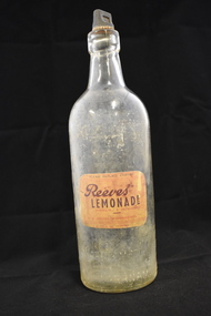
Bottle, Reeves Lemonade - with label, 1940s
This bottle comes from the Warrnambool aerated waters factory of Ralph Reeves. This business was established in Koroit Street, Warrnambool in the 1860s as the Union Cordial Factory by John Davis and then bought by John Fletcher in 1885. Fletcher’s business continued until 1930 when it was bought by Ralph Reeves. Coming to Warrnambool about 1900 Reeves had managed a Banyan Street, Warrnambool factory which had been established by John Rowley. Reeves was joined by his son Reg in Warrnambool and Reg operated the business from 1946 to 1972. The trade name of Reeves was still used after Reg Reeves died in the early 1970s and continued on for some years. This bottle is of interest as an example of an early Reeves bottle. We have few Reeves bottles with the original paper labels. Cordial manufacturing in Warrnambool was an important industry for over 100 years.This is a clear glass bottle with a rounded base and rounded body tapering to a short round neck with a moulded glass top at the opening. The screw stopper is black and made of composite material. The inside of the bottle is discoloured. The details of the manufacturer of the contents are impressed into the glass on the side and there is a paper label pasted on the side of the bottle (black, red, yellow tonings) ‘R.V. Reeves’ (x2) 34’ ‘Lemonade Warrnambool Cordials Pty Ltd’ ‘Bottle not complete without stopper’ ‘This bottle is the property of Warrnambool Cordials Pty Ltd Warrnambool’ ‘Please replace stopper, Reeves lemonade, sparkling & refreshing, R.J. Reeves Warrnambool, bottle 2d. deposit’ ralph reeves, warrnambool, cordial manufacturers in warrnambool, history of warrnambool