Showing 4496 items
matching farms
-
 Eltham District Historical Society Inc
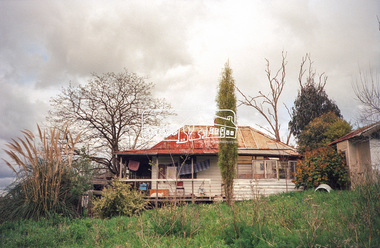
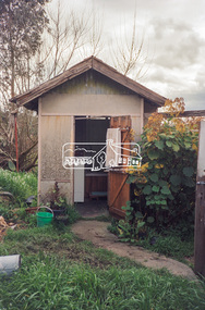
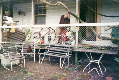
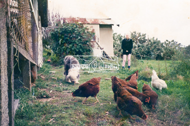
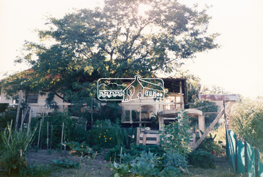
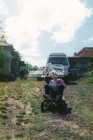
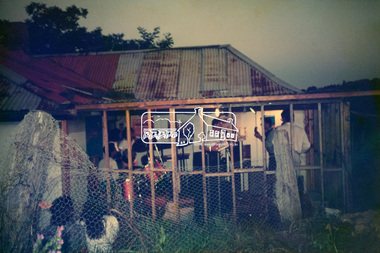
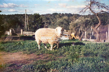
Photograph, Hans Gregory, Original 1860s William West house, Fabbro's Farm, Falkiner Street, Eltham, c.1990
Photos taken by Hans Gregory who along with partner Pauline Steele, rented the original old 1860s William West Cottage situated behind the Fabbro family home. Hans was employed as a Youth officer with the Shire of Eltham at the time and was the last tennant on the property. The property was sold and in 1995 was developed for residential housing as the Riverview Park estate. Guido Quarto Fabbro was born 21 August 1891 at Treppo Grande in the far northeast of Italy, the son of Giacomo Fabbro and Anna Geruzzi. Regina Moretti was born 6 March 1893 at Treppo Grande, Italy, the daughter of Giovanni Battista Moretti and Maria Teresa Coletti. Guido and Regina married about 1917 and they had two sons, Giacomo (John c.1918) and Maurie (c.1920). In 1925 Guido Fabbro departed his homeland from Genoa, arriving in Fremantle, Western Australia in June, travelling 3rd class aboard the ship, Caprera. Regina and their two boys followed a year later along with other family members arriving in Fremantle from Genoa 4 July 1926 aboard the Moncalieri. The Fabbros arrived in Eltham in 1933 and purchased a block of land from William West on the western side of Falkiner Street, extending to Ely and Porter Streets which had formerly been part of the West family orchard and dairy farm. As there was no fencing dividing the two properties, West served notice on Guido in December 1934 to bear half of the cost of £6. When payment was not forthcoming, West sued Guido in the Eltham Court in January 1935. Guido failed to appear and was not represented, and costs were ordered in West’s favour. Guido and Regina built a large Italianesque house on their property. The original 1860s cottage was relocated to the back of the block and was rented out (once to Alistair and Margot Knox). Guido also purchased land extending to the Diamond Creek on the eastern side of Falkiner Street and on the eastern side of Bell Street (opposite Eltham High School). The riparian soil was suitable for market gardening: Guido grew mainly tomatoes, but also pumpkins, cauliflowers, cabbages, peas, beans, lettuce, beetroot and zucchinis. Even the land surrounding the house was used. The produce was carted to Melbourne overnight for sale at the market. Guido died in 1970 and is buried in Eltham cemetery. Regina died 1986. She and their son John Patrick (Giacomo) Fabbro who died in 1984 are also buried at Eltham Cemetery. Guido’s son Maurie continued in his father’s footsteps until 2007, principally growing artichokes in later years. He died in 2009. The land on the eastern side of Falkiner Street now forms part of a Council reserve called “Barak Bushland”, the land on the western side having been sold off for residential subdivision. The Bell Street land is now public open space managed by Nillumbik Shire Council and called “Fabbro Fields”. There have been recent proposals to develop the site for sporting purposes or as a dog park or community garden. Provides an insight into early settler's farmhouses and farming property of the Eltham district.guido quarto fabbro, regina fabbro (nee moretti), william west, maurie fabbro, fabbro's farm, hans gregory, west family orchard, west dairy farm -
 Eltham District Historical Society Inc
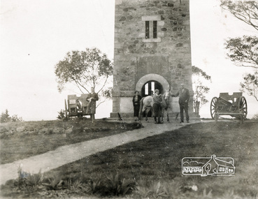
Photograph, Shire of Eltham War Memorial, Memorial Park, Garden Hill, Kangaroo Ground; Eltham Heritage Tour, 24 May 1992, 24/05/1992
ELTHAM HERITAGE TOUR The Society excursion on 24th May 1992 was arranged by David Bick, leader of the team carrying out the Shire's heritage study. David selected a number of sites or buildings identified in the study, some of them lesser known components of the Shire's heritage. The tour commenced at the Eltham Shire Office at 10.00 am. Travel was by private car and mini-bus with stops at about twelve locations for commentary by David.It included a short walk in Hurstbridge and lunch at Kinglake. Highlights of the tour included: - 10 am Leave from Shire Offices - 3 Important Trees - A Physical Link to Eltham's First Settlers - Toorak Mansion Gates - A Surviving Farm House - An Intact Circa 1900 Main Street - First Settlers - Gold Miners, and Timber-getters - An Early Hotel - A Pioneering Homestead - Changing Eltham Shire - 20th Century - 4 pm Afternoon Tea and Finish Tour Extract from ELTHAM CULTURAL HERITAGE TOUR (Newsletter No. 85, July 1992, by Bettina Woodburn) "Now we drove through stands of pines to the Kangaroo Ground Lookout Tower, a most unusual War Memorial, World War I. The tower and a shed/residence (it had a chimney) were built from local sandstone. Below to the south and east of Melbourne spread 'suburbia'. Close by the landscape seemed so contrived - English fields and hedgerows! Although only about twenty inches deep, the soil of this ancient volcano, its crater lost under subsequent weathering, was rich, deserving the name of "Garden Hill". Now native trees are taking over again. In Kangaroo Ground itself stand the inevitable Store, School and Church - and two Norfolk pines and a monkey puzzle tree." On November 11th 1926 the Shire of Eltham War Memorial Tower at Kangaroo Ground was opened. It is regarded as one of Melbourne’s most outstanding lookout towers. It commands a magnificent 360 degree panorama from Kinglake across the Diamond Valley to Macedon and the You Yangs. It is built on a peak which was once a volcano, 237 metres above sea level. After World War one a memorial cairn was erected on the site, and in 1925 a committee of public-minded citizens began to plan for a tower. Many generous donations of material and money were forthcoming so that in 1926 the Governor General Lord Stonehaven was able to unveil the plaque before a crowd of 500 people. There was some concern in the 1960s when the Forests Commission wanted to build a firespotters cabin on the top. At first R.S.L. branches opposed the idea, but it was realised that this use could combine with its use as a tourist attraction, and would ensure its maintenance for the future, Today the Kangaroo Ground tower provides one of the best views around Melbourne and is a fitting memorial to those who died in two world wars. From: Historic items for Diamond Valley Community Radio September 1990 (EDHS collection) Record of the Society's history and activities and highlighting various aspects of the Heritage Study undertaken by David Bick used to create the future heritage overlay for the Shire of Eltham and later Nillumbik Shire.Roll of 35mm colour negative film, 4 stripsKodak Gold 100 5095culture, events, garden hill, kangaroo ground, kangaroo ground memorial, memorial park, shire of eltham war memorial tower, war memorials -
 Flagstaff Hill Maritime Museum and Village
Furniture - Plant Stand, Late 19th Century (1898)
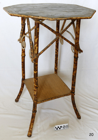
During the years 1869-1935 there were well over 250 registered bamboo furniture producers in Britain. The earliest recorded firm was Hubert Bill of 14 Little Camden St, London N.W., who claimed to have been established in (1869) while Daniel Jacobs & Sons of Hackney Road, London, were still in business in 1915, after 45 years of production. Design, quality, price and methods of construction were fairly consistent throughout the whole period, but it was the imaginative and often eccentric choice of subject matter that marked differentiation between the various firms. While most produced standard tables, stands and fire-screens, the more adventurous offered for sale items such as corner shelve units, charcoal barbecue grills and musical tea tables. Shelves were often covered with embossed leather paper designs, at first imported from Japan and then later produced in England. Some firms incorporated the knobbly roots of the bamboo stems into their designs, generally to form feet. Occasionally handles to drawers and cupboards were made with these roots although they were more commonly carved as imitations. Handles were mostly of cheap metal or brass. The ends of the bamboo canes were capped with stamped metal or turned bone, ivory or wooden discs. Methods of construction fell into three categories. First and most common is that of pegging. Bamboo stems being hollow, thick dowels can easily be glued into the joints. Some firms farmed out this work of `plugging' the ends of the canes to part-time workers at home. The second method, that of pinning, was far less satisfactory as bamboo tends to split lengthwise and therefore the jointed pieces eventually disintegrated. The most efficient method was that patented in 1888 (patent No 2383) by the firm of W. F. Needham in Birmingham. It consisted of metal shoes and covers for all joints which were made by wrapping a metal strip around the stems and soldering the overlapping ends. Some joints were further strengthened by a small pin or screw. Needham was by far the largest and most successful manufacturer and their individual and superior method of construction undoubtedly gained them their reputation. A. Englander & Searle of 34 Gt Eastern St and 31 Mare St, Hackney, London, were a firm particularly concerned with methods of construction. Although they seem to have entered the bamboo furniture market at a comparatively late date, about 1898, they produced inexpensive' bamboo, aimed particularly at the export trade. Stating in their catalogue that bamboo furniture “can be exported in one piece or it can be exported in pieces and put together again. The fixing up is much facilitated by a system of marking and numbering. Further, no glue is required for putting together as the screw system only is applied”. This method of construction best fits the Etagere and this item in the flagstaff collection and it is believed to have been made by A Englander & Searle, exported in a knock down form to Australia, purchased in kit form from a dealer here and put together by the purchaser. The bamboo plant stand is a significant item as it highlight furniture fashion of the late Victorian era. This item was highly sort after in its time and although mass produced, not many examples remain because the item is so fragile so this example is a valuable addition to the Flagstaff collection. It is believed,the construction method used is by a notable and respected maker in England of bamboo furniture that was aimed specifically at the export market and probably came to Australia in kit form to be assembled by the purchaser.Bamboo plant stand with octagonal top edged with tortoise shell bamboo the top is of wood and supported by four tortoise shell bamboo legs joined at the base by a square cane covered shelf. The tortoise shell appearance is brown lacquer. Item is part of the Giles Collection. flagstaff hill, warrnambool, shipwrecked coast, flagstaff hill maritime museum, shipwreck coast, furniture, plant stand, bamboo furniture, etagere, victorian furniture, simulated bamboo, tortise shell, a englander & searle, domestic furniture, giles collection, henry giles, cooramook, mailor’s flat, wangoom, 19th century household goods -
 Melton City Libraries
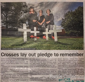
Newspaper, Crosses lay out pledge to remember, 2015
"The outbreak of World War I in August 1914 had an immediate impact on communities across Australia, and it was no different in Melton. Young men began enlisting immediately, and Australia’s initial offer of 20,000 troops was soon exceeded by Victorian enlistments alone. Over the four years of the war, approximately 114,000 Victorians enlisted and around 91,000 servicemen and women were sent overseas. They came not just from Melbourne, but from all over the state; from farms, small towns and suburban areas. They included locals, newly arrived migrants and Indigenous people. The Australian home front was a hive of activity throughout the war, and the Melton community played its part. Following the announcement that Australia was joining the war with Great Britain and its allies on 5 August 1914, the Melton community lost no time in launching into action. A meeting ‘to assist the Red Cross fund’ was held in the Melton Mechanics’ Institute hall on 18 August – just days after the outbreak of the war. Collectors were appointed for each corner of the shire and individual donations were made. A Melton branch of the Australian Red Cross Society was formed in June 1915 and focused its energies on raising funds to purchase material that was used to make clothes for sick and wounded soldiers. A depot was established in Melton to collect clothing and other ‘comfort’ items for the soldiers – including reading material, tobacco, linen, canned foods and soap – and to coordinate the branch’s work and activities. Local cab driver Percival Stubbs volunteered to transport all the packages to the Melton railway station, until he enlisted and departed for the front in 1916. Such were the numbers of people getting involved that branches were also established in Toolern Vale and Rockbank. Regular community events were held to farewell soldiers who were leaving on active service and to welcome those who returned home. Gunner Robert (Bob) Wynne, whose uncle’s family ran the general store in Toolern Vale, was presented with a pair of field glasses (binoculars), a gold watch, inscribed locket and autographed letter by the Toolern Vale community before he set sail for the front in 1916. His mother noted that he ‘sailed away in good spirits with a smile till out of sight’. From June 1915 to June 1919, the Melton Red Cross branch donated 2,156 pairs of socks, 1,357 shirts, 425 kit bags, 251 pillowslips, 224 towels and 121 pairs of pajamas. Countless fundraising events were held, including jumble fairs, concerts and gift evenings. Local schools also encouraged students to contribute through fund-raising and making and collecting comforts for the soldiers. People across the country engaged in similar activities, but Victoria’s rural communities found unique ways of contributing. In Melton, people were encouraged to send rabbits and hares ‘in good condition’ to an exporter in Spencer Street, for export to Belgium ‘for the relief of those suffering". Special Anzac Memorial article featured in the Star Weeklylocal identities, war -
 Melton City Libraries
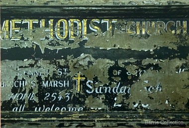
Photograph, Signboard, 1972
Edna Barrie handwritten notes – copied 18th October 2013 web The early story of the Wesleyan Methodist Church in Victoria At Melton between Bal [Ballarat] and Melb [Melbourne] was introduced by the Revd Wlm Blamires in 1862 ably seconded by the late Mrs Westlake (afterwards Mrs Spargo). Mr J James, the active and indefatigable Revd Eb Taylor and such workers as Atkinson Corr and Ferris. Mawson and John Dare 1867 the foundation stone of the present church was laid. Revd D Waugh 1867. Melton and Toolern Vale have benefited by the generous help of Mr J Browne esquire of White Hills Station Diggers Rest and are now comprised in the Sunshine Circuit. Written at a later date – Wesleyan 16-4-1867 then Methodist 3-10-1867. Bluestone building cost Lsd 350-13-6. Seating 40 pounds Rev Ken Moore Methodist opened at Brooklyn Rd Melton South c1940 closed c 1972. Timber Church shifted from Staughton Vale, prior to this Services held in Victoria Hall Melton South. The source of the information – ? and date notes were made On the Chart outlining Melton Churches the following additional notes- At opening (nil Plaster, nil ceiling) Slate roof. Closed 1910-1911- most likely from 1867 Express My research - Melton Express noted 15th Aug 1939 porch added to Church at Melton South making the date earlier than 1940. Photographs taken when the building was being used as the UC Opp Shop and demolition of the building showing the porch. Charles Ernest Barrie was prominent in the life of the Methodist Church and established a thriving Sunday School. He built the Chaff Mills at Melton South in 1900. In 1910 he sold the Mill to Glover Onians and moved to a farm at Trundle NSW, where he lived for about a year. In May 1911 he purchased “Darlingsford” in Melton when it came on the market. The address Elizabeth St Moonee Ponds appears in the family records during this period and during WW 1 they also lived at Ascot Vale where the Lang parents lived. On returning after the war to Melton to occupy the Darlingsford house, which had been occupied by a caretaker. The family joined the Presbyterian Church. Evidenced in the Church Minute Book. 1920 What happened to the Methodist Church between 1910 – 1920? How long did it exist while in the Bluestone building in Palmerston St (Heritage listed 2008) When did the church commence in Victoria Hall? Built 1910 on land donated by C E Barrie. I attended the Methodist Church Melton Sth when monthly services were held in the afternoons. We were members of the Presbyterian Church and also supported the Melton Sth Church during the 1950’s Signboard from Melton South Methodist Churchchurches -
 The Beechworth Burke Museum
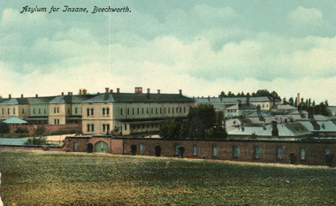
Postcard, C. F. Falk, c.1930
This postcard contains a depiction of the Mayday Hills Hospital in Beechworth, Victoria from the direction of Farm Hill, circa 1930. It was designed by C.F.Falk in Beechworth and printed in Saxony which is a landlocked state of Germany which borders the states of Brandenburg, Saxony-Anhalt, Thuringia, Bavaria and the countries of Poland and the Czech Republic. The depiction is a painting of the Mayday Hill Hospital which portrays the extensive buildings an HaHa wall (many of which have not survived to the present day). It provides a unique opportunity to reconstruct this historical site as it may have looked in approximately 1930. Beechworth's Mayday Hills was chosen as the site of Victoria's newest asylum, at the time, due to the landscape and altitude. The hilltop atmosphere and the native fauna, it was argued, would assist in the cure of the patients kept at the hospital (Wood 1985, 122). The positioning of the hospital had a beneficial effect on the rural town. A pamphlet published by James Ingram and Son (1849) reveal that famous landmarks in Beechworth which included the Post Office, Gaol, Courthouse and Asylum "demonstrate the appreciation of Beechworth by the Government not only as as important district center, but also as a site unrivaled as a sanitarium". There were other locations in contention at the time, but ultimately Beechworth was chosen (Craig 2000, 33). The extent of buildings displayed in this postcard helps convey the imposing and enormity of the structure before decommission. Prior to the creation of the Asylum in Beechworth, those charged with having mental illnesses or, as it was termed, "insanity" were unable to be properly cared for in the Gaol (which is where they were often sent). John Buckley Castieau wrote, in 1861 for the Ovens and Murray Advertiser, that the Gaol was unable to properly care for those classified then as "insane" but that they would endeavor to treat them above the other inmates (which he notes is not always the case in other establishments). Castieau wrote this in favour of supporting the building of the Mayday Hills Hospital in Beechworth. It was stated that at the time the Mayday Hills Hospital was built, there were 83 prisoners kept in the Gaol who were to be rehoused to the Hospital on the grounds of "insanity". The classification as someone as "insane", in this period of time is a reflection on the inability to cure and understand illnesses of the mind during the mid to late 1800s. The title on the obverse of this photograph as "Asylum for Insane, Beechworth" reflects a bygone era and attitude to mental health. Beechworth's Mayday Hills was chosen as the site of Victoria's newest asylum, at the time, due to the landscape and altitude. Opening on the 24th of October 1867, the Mayday Hills Hospital was originally named the "Ovens Lunatic Asylum", a title which is very much a product of its time. Whilst controversial, changes to the name is part of the history of the Hospital and can provide much insight into the understanding of mental illness throughout history and the use/disuse of this term provides information into the reception/changing opinions of mental illness in society. The Hospital would later become known as the "Mayday Hills Asylum" and/or "Mayday Hills Hospital" with the latter being the most commonly used title. An article in the Ovens and Murray Advertiser notes that on the 7th of March 1865, the foundation stone of the Hospital was laid (it would officially open in 1867) and that it was such a moment of accomplishment and joy for Beechworth that a letter to the editor even suggested that there should be a holiday dedicated to the day the foundation stone as laid. This reveals an extent to which the townspeople of early Beechworth valued the construction of the Hospital in their town. It provided the town with a sense of prestige and honour.At first glance, the remains of the Mayday Hills Hospital in Beechworth, Victoria, inspire tragedy, trauma and beauty. The buildings themselves, with their Italianate style Renaissance architecture designed by J.J. Clark (Craig 2000, 49 & Smith 2016, 203) reflect a bygone period of European and Australian history. The gardens provide a sense of tranquility and beauty. The experience of those within these walls remains a valuable area of study to provide a more complete understanding. This particular hospital is considered the fourth of its like and one of three identified as the largest of their kind. The Mayday Hills Hospital is a sister to the Kew and Ararat Asylums in Melbourne which are both located in relative proximity. Understanding the role of the Mayday Hills Hospital in Beechworth history is integral to understanding the development of the goldfields town, but also for providing important information as to the history of caring for, and the reception of, mental illnesses in Australian and wider European history. Mayday Hills provides a case study which can be researched through oral history, an analysis of the grounds/buildings and through images like this postcard which portray the structure in a highly deliberate manner. Images like this depict the strong façade of the Hospital and provide a glimpse into the tranquility of the gardens. This has been done deliberately to provide a sense of comfort and healing about the building to those looking from the outside. Further research into the importance of the Hospital in Beechworth and it's connection to the town will be supported through images like these kept in the Mayday Hills photo album in the collection of the Burke Museum.Colour rectangular postcard printed on cardObverse: Asylum for Insane, Beechworth. / Reverse: C.F. Faulk, Beechworth. Printed in Saxony. POST CARD / ADDRESS ONLY / AFFIX / STAMP / B 2298 / 1997.2457 /mental hospital, insane asylum, mayday hills mental hospital, beechworth, mayday hills, asylum, gold town, north-east victoria, ararat asylum, kew asylum -
 Eltham District Historical Society Inc
Postcard - Photograph postcard, Panorama at Eltham, Vic, c.1923
The Rose Series P. 4284 post card Taken from near what would be present day CLC car park looking southwest across Diamond Street, present-day Andrew Park to the railway station and developing Eltham shopping precinct. Arthur Street visible, Pryor and Luck Street not evident. Sunnybrook, the Taylor home is visible at the top of the hill in Bible Street. Only three residences visible in Arthur Street on the southern side, two of these are the David Harbison Rest Home at 10 and 12 Arthur Street (built and opened in November 1919), present day site of Eltham Mall. There are none on the north side of the street. Based on 1945 aerial view there are 8 buildings on the northern side between Main Road and Bible Street which and given the extent of commercial development on Main Road, it is estimated this image is circa 1925. Luther Haley was the first to build an open a baker and General Store in this location next to the railway station in 1902. However, it took nearly twenty years until the early to mid-1920s when a period of significant growth in the Eltham shopping centre happened with many businesses relocating their operations from the original town centre of Maria Street in Little Eltham as well as new businesses opening. Other stores/buildings noted (L-R) are: Stationmaster's House built circa 1910 Eltham Hardware Store opposite the railway station first opened on Main Road opposite the Railway Station around late 1922. An advertisement placed in the Hurstbridge Advertiser advised that the Hardware Store had just opened with a varied stock of Saws, Hammers, Nails, Shovels, Screw Drivers, and every article required in a house or on a farm. People were also encouraged to try their Jams, Pickles, Sauces, Cups and Saucers, etc. Newsagency with 'Leader' advertising on awning - E. J. Andrew opened his newsagency shop opposite the station in March 1923, advertising for sale stationery, school requisites and periodicals. Bird Brothers Cash Grocer & Fruiterer opposite the railway station offering summer drinks and confectionery a specialty with a full Stock of groceries of the best quality always on hand at city prices opened December 1921 William Capewell's Butcher shop at the corner of Dudley Street. Capewell previously had a small shop in front of the station opposite Luck Street. He enlisted in the AIF during WW1 and returned home in 1919. He re-applied for a slaughtering license in February 1920 and was advertising by October 1922 supplying all districts. Not visible (or not yet identified) but in business by October 1922 were: J.H. Fraser, Carpenter and Builder at Luck Street opposite the station George A. Danslow, Hairdresser and Tobacconist opposite the railway station Miss Barber's 'Blue Gum' Soda Fountain opened October 1922 opposite the railway station (hidden behind Stationmaster's House). It was so named due to its proximity to a tall Blue Gum tree G.H. McDonald Boot Repairer opposite the railway station In December 1923 the first portion of the main street to be formed from Dudley to Arthur streets was almost completed. This is the section in front of Capewell's Butcher shop though it is difficult to fully make out from the photoDigital file only Postcards scanned from the collection of Michael Aitken on loan to EDHS, 2 Sep. 2022michael aitken collection, eltham, postcards, arthur street, david harbison rest home, electrine candles, eltham railway station, eltham shopping centre, lloyd's general store, red rattler, rose series postcard, rose stereograph company, tait train, velvet soap, andrew park, bible street, bird brothers cash grocer & fruiterer, bird brothers cash grocer and fruiterer, butcher, diamond street, dudley street, eltham hardware and timber, eltham hardware store, eltham mall, main road, station masters house, stationmaster's house, sunnybrook, w.j. capewell, w.j. capewell butcher shop -
 Flagstaff Hill Maritime Museum and Village
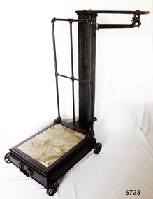
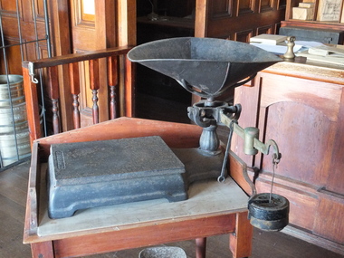
Functional object - Platform Scales
Thaddeus Fairbanks (1796 –1886) was an American inventor. of heating and cook stoves, cast iron ploughs, and other items. His greatest success was the invention and manufacture of the platform scale, which allowed the weighing of large objects accurately. Fairbanks was born in Brimfield, Massachusetts, on January 17, 1796, the son of Joseph Fairbanks (1763–1846) and Phebe (Paddock) Fairbanks (1760–1853). His uncle was Ephraim Paddock, the brother of Phebe Paddock. In 1815 he moved to St. Johnsbury, Vermont, and set up a wheelwright's shop above his father's gristmill. In 1820 he married Lucy Peck Barker and In 1824 he built an iron foundry. his brother Erastus joined him to establish E. and T. Fairbanks, a partnership to manufacture heating stoves, cast iron ploughs a design for which he patented in 1826. In 1830 Fairbanks and Erastus became interested in the raising and processing of hemp. Fairbanks went on to patent a hemp and flax dressing machine and became the manager of the St. Johnsbury Hemp Company. He also built a set of scales that would measure large loads of hemp accurately, as there were no reliable scales at the time. Upon the success of building these scales, his brothers recommended that he make and sell these for general use. Fairbanks' most famous invention then became the platform scale for weighing heavy objects. These are commonly known as the Fairbanks Scales, for which he patented his original design in 1830. Before this time, accurate weighing of objects required hanging them from a balancing beam as a result, particularly heavy or ungainly objects could not be weighed accurately. A platform scale, if large enough, could weigh an entire wagon. By placing a full wagon on the scale, unloading it, and then placing it on the scale when empty, it became possible to easily and accurately calculate the weight and value of farm produce and other loads. In 1834 Fairbanks and his brother formed "E. and T. Fairbanks and Company" to manufacture and sell these platform scales. These scales were well known in the United States and around the world resulting in the company doubling in volume every three years from 1842 to 1857. There was a temporary slow down during the American Civil War, however, the business took off again after the war. Their partnership was incorporated in 1874 into a firm known as "Fairbanks Scale Company". These platform scales revolutionized weighing methods of large loads and have been in use ever since. Portable platform scales are found in almost every hardware store, physician's office, and manufacturing factory throughout the United States and the world. The first railway track platform scale patent was granted to Fairbanks on January 13, 1857, as Patent No. 16,381. In 1916 the company was purchased by ”Fairbanks, Morse and Company”. Ownership of the company has since changed several times, but Fairbanks Scales continue to be made in St. Johnsbury Vermont to this day. Fairbanks had received 43 patents in his lifetime with the last one at the age of 91. He died on April 12, 1886, and is buried at St. Johnsbury, Vermont, at the Mount Pleasant Cemetery. An early example of the first type of platform scale that revolutionised the weighing of goods throughout the world made in the USA around the turn of the 19th century. Commercially built platform scale on wheels. Cast iron base supports iron weighing platform with wooden floor. At back, square hollow wooden post supports a hooded rod which bears the weight of the platform and which hooks onto a brass balancing arm, marked in pounds up to 50. There is a cylindrical sliding weight and on the end a loop for a metal weight holder. The holder is designed for three circular pieces of metal with a slit to the centre. The weights used are 50, 100 and 200 lbs.Embossed to base Fairbanks Patent No 11 1/2, flagstaff hill, warrnambool, shipwrecked-coast, flagstaff-hill, flagstaff-hill-maritime-museum, maritime-museum, shipwreck-coast, flagstaff-hill-maritime-village, platform scales -
 Eltham District Historical Society Inc
Photograph, Monash Bridge, Arthurs Creek Road, Hurstbridge, Eltham Heritage Tour, 24 May 1992, 24/05/1992
ELTHAM HERITAGE TOUR The Society excursion on 24th May 1992 was arranged by David Bick, leader of the team carrying out the Shire's heritage study. David selected a number of sites or buildings identified in the study, some of them lesser known components of the Shire's heritage. The tour commenced at the Eltham Shire Office at 10.00 am. Travel was by private car and mini-bus with stops at about twelve locations for commentary by David.It included a short walk in Hurstbridge and lunch at Kinglake. Highlights of the tour included: - 10 am Leave from Shire Offices - 3 Important Trees - A Physical Link to Eltham's First Settlers - Toorak Mansion Gates - A Surviving Farm House - An Intact Circa 1900 Main Street - First Settlers - Gold Miners, and Timber-getters - An Early Hotel - A Pioneering Homestead - Changing Eltham Shire - 20th Century - 4 pm Afternoon Tea and Finish Tour Extract from ELTHAM CULTURAL HERITAGE TOUR (Newsletter No. 85, July 1992, by Bettina Woodburn) "On the Arthurs Creek Road is a bridge designed by Monash, which we admired before walking across the little park with a mud-brick and timber shelter, to the Hurst family graveyard. There are two marked graves, one, Henry who was shot by Burke the bushranger and a cairn has a plaque listing others buried here from 1866 onwards. Burke was captured and tied to the wheel of a dray under the eucalypt near the waterhose/standpipe. Close by the kindergarten, at this place are three trees on the National Trust Register, a Canary Island pine, a Canadian cedar and probably a spruce. Radiata pines and a thick bolled peppercorn surround the little cemetery. Continuing along Main Street we notice elm trees planted as a war memorial, then on the left a 1930 timber house, a 1910 store and residence, resplendent with wrought iron trim, a double fronted Hardware Store and cypresses on the back alignment of a new vacant block. On the right side of the street is a less interesting attempt at an 'in character' shop. Further on are more early homes, one tucked away at the rear with two tall palms by the front steps. Another curiosity is a rounded veranda corner and there are more galvanised iron sheds or garages, before a mud-brick Dentist's Surgery. Beyond the round-a-about is St Peters Church, of mud-brick construction shared by Catholic and Anglican parishioners, overlooking the river flood plain. Leaving Hurstbridge on the Kinglake Road, we ate our picnic lunch beside the communication tower and enjoyed views of Melbourne, Yan Yean Reservoir and the distant Dandenongs beyond the spreading suburbs. Next we drove to the North West boundary of the Shire at Masons Falls Road towards Whittlesea. On the way to the North East Boundary we passed St Peters, a yellow wooden Church with a Tudor Archway; built in the early 1920's in the style of the 1860's. From the Healesville-Kinglake road the rolling hills had European aspects, the hedged fields and chestnut trees. Then it was back down the Hurstbridge Road through 'Aussie' bush of towering gums, with bracken and scrubby understorey, the Kinglake National Park, before more open country with deciduous trees planted in line, and a creek lined with willows."Record of the Society's history and activities and highlighting various aspects of the Heritage Study undertaken by David Bick used to create the future heritage overlay for the Shire of Eltham and later Nillumbik Shire.Roll of 35mm colour negative film, 4 stripsKodak Gold 100 5095shire of eltham historical society, activities, heritage tour, hurstbridge, monash bridge, arthurs creek road -
 Eltham District Historical Society Inc
Photograph, Memorial Tower, Kangaroo Ground c.1934, 1934c
Sepia photograph of Joyce McMahon and 'Tiny' Carroll at the War Memorial Tower, Kangaroo Ground c.1934. The guns were installed in 1934 and removed in 1942. Taken in the early 1930s, the photograph ... shows the Kangaroo Ground Tower of Remembance with Joyce McMahon, daughter-in-law of Mr. P. J.McMahon, the then Shire of Eltham Secretary, her horse and a very tall person patting the horse. He is ex-serviceman W. "Tiny" Caroll who was the council's caretaker of the surrounding War Memorial Park. He lived in the stone cottage which still stands in the park. "Tiny" is seen as the fictional character "Tiny Bourke" who, in author Alan Marshall's book "This is the Grass", "was a giant of a man, well over six feet high, with huge hands that completely encircled the cup of tea". The bronze casting, which shows the 79 names of those who paid the "supremen sacrifice" in World War 1 (1914-1918), was erecfed above the entrance to the Tower in September, 1930. The Monterey cypress trees which now form the windbreak around the park's fenceline, were just knee high in this photograph. They were planted in August 1926, with all the plantings paid for, and done, by the public as the Tower was being erected. The two field guns have been identified as of German origin, Krupp 77 mm calibre captured on October 4, 1918 at Geneve, France. They were removed in 1943/44 as a wartime requirement of the Australian Govenment. A public notice dated October 16, 1926 by Cr. H Rutter, Chairman of the Eltham Soldiers War Memorial League stated: "On the summit of that central and conspicuous landmark, Garden Hill, there is being erected a massive memorial tower which will, for all time, remind every passerby of the part played by the men of the Shire of Eltham in the Great War. The work has been undertaken by the people of the Shire a a tribute of love and admiration for those who were known and dear to use in the days of their youth and early manhood, who went out from amongst us, never to return, and whose self-sacrifice has made us, each and all, thier ever-lasting debtors" Harry Gilham, Eltham District Historical Society Kangaroo Ground Tower of Remembrance, A Journey in Time: a column about Nillumbik's history, Nillumbik Mail, 9th August, 2000 Since that research the following has been sourced from Eltham and Whittlesea Shires Advertiser and Diamond Creek Valley Advocate, April 8, 1921, p. 3 Retrieved April 25, 2020, from http://nla.gov.au/nla.news-article57639687 Eltham Shire Council From Town Clerk, Melbourne, stating that a light machine-gun captured by the 22nd battalion, A.I.F. at La Motte Farm, near Beaurvoir, on Oct. 3rd, 1918, during the operations which won the Beauvoir line and completed the smashing of the great Hindenburg defence-system, has been alloted to the Shire of Eltham. - On the motion of Crs Hubbard and Smedley, it was decided to have the gun placed in the Memorial Park. Sepia Photographgarden hill, gun, joyce mcmahon, kangaroo ground, memorial tower, shire of eltham war memorial tower, tiny carroll, war memorials, war trophy, william carroll -
 Flagstaff Hill Maritime Museum and Village
Functional object - Platform Scales, Thaddeus Fairbanks, 1880-1910
Thaddeus Fairbanks (1796 –1886) was an American inventor. of heating and cook stoves, cast iron ploughs, and other items. His greatest success was the invention and manufacture of the platform scale, which allowed the weighing of large objects accurately. Fairbanks was born in Brimfield, Massachusetts, on January 17, 1796, the son of Joseph Fairbanks (1763–1846) and Phebe (Paddock) Fairbanks (1760–1853). His uncle was Ephraim Paddock, the brother of Phebe Paddock. In 1815 he moved to St. Johnsbury, Vermont, and set up a wheelwright's shop above his father's gristmill. In 1820 he married Lucy Peck Barker and In 1824 he built an iron foundry. his brother Erastus joined him to establish E. and T. Fairbanks, a partnership to manufacture heating stoves, cast iron ploughs a design for which he patented in 1826. In 1830 Fairbanks and Erastus became interested in the raising and processing of hemp. Fairbanks went on to patent a hemp and flax dressing machine and became the manager of the St. Johnsbury Hemp Company. He also built a set of scales that would measure large loads of hemp accurately, as there were no reliable scales at the time. Upon the success of building these scales, his brothers recommended that he make and sell these for general use. Fairbanks' most famous invention then became the platform scale for weighing heavy objects. These are commonly known as the Fairbanks Scales, for which he patented his original design in 1830. Before this time, accurate weighing of objects required hanging them from a balancing beam as a result, particularly heavy or ungainly objects could not be weighed accurately. A platform scale, if large enough, could weigh an entire wagon. By placing a full wagon on the scale, unloading it, and then placing it on the scale when empty, it became possible to easily and accurately calculate the weight and value of farm produce and other loads. In 1834 Fairbanks and his brother formed "E. and T. Fairbanks and Company" to manufacture and sell these platform scales. These scales were well known in the United States and around the world resulting in the company doubling in volume every three years from 1842 to 1857. There was a temporary slow down during the American Civil War, however, the business took off again after the war. Their partnership was incorporated in 1874 into a firm known as "Fairbanks Scale Company". These platform scales revolutionized weighing methods of large loads and have been in use ever since. Portable platform scales are found in almost every hardware store, physician's office, and manufacturing factory throughout the United States and the world. The first railway track platform scale patent was granted to Fairbanks on January 13, 1857, as Patent No. 16,381. In 1916 the company was purchased by ”Fairbanks, Morse and Company”. Ownership of the company has since changed several times, but Fairbanks Scales continue to be made in St. Johnsbury Vermont to this day. Fairbanks had received 43 patents in his lifetime with the last one at the age of 91. He died on April 12, 1886, and is buried at St. Johnsbury, Vermont, at the Mount Pleasant Cemetery. An early example circa 1900 of the first type of platform scales used in a grocery store. This design for accurately measuring goods that were sold over the counter revolutionised the weighing of goods throughout the world. Platform scale metal black with removable tray & pan. Has horizontal brass arm with a brass slide weight black removable weight hook and 2 x 2 lb. weights. Fairbanksflagstaff hill, warrnambool, shipwrecked-coast, flagstaff-hill, flagstaff-hill-maritime-museum, maritime-museum, shipwreck-coast, flagstaff-hill-maritime-village -
 Wodonga & District Historical Society Inc
Mixed media - John Kenneth Darnton Watson and de Kerilleau Homestead
de Kerilleau was built for William Huon, son of the early pastoralist Paul Huon, in 1870 and named after the family's ancestral estate in France. The original lease of the Wodonga Run was granted to Paul Huon as No. 202 on 7th February 1837, about a year after his cousin Charles Huon had squatted on the land. Kenneth Darnton Watson bought de Kerilleau homestead in 1922 where the Watson family lived for three generations, caring for the land and serving the Wodonga community. Kenneth, his son Ian Darnton Watson and his grandson John Kenneth Darnton Watson all served on the Wodonga Council. The magnificent two storey brick homestead is built on ground above Wodonga Creek. The home of Georgian style consists of eleven rooms and a spacious cellar. At the rear of the main house in a separate single storey building was a large kitchen, pantry and accommodation for a cook and a housemaid. A feature of the homestead is the cast iron lace on the veranda and upper balcony, both supported by caste - iron pillars. The granite foundations of the home were quarried from the hill above the homestead. The enormous Moreton Bay Fig tree which stands to the side of the home was planted when Sir Charles Bowen visited de Kerilleau to mark the opening of the rail line that connects Victoria with New South Wales. Planted in 1873, it is still standing today. This painting was donated to the Wodonga Historical Society by George, Digby & Dugald Watson on behalf of the late John & Chris Watson. John Kenneth Darnton Watson was born on 28 August 1960 in Wodonga. After completing his primary schooling locally, he boarded at Geelong College from 1973. John joined the rowing crews, starting in the 8th VIII crew and reaching the 1st VIII crew in 1978. He received multiple House colours awards for cross country, athletics and rowing and received School colours for rowing. On completion of his schooling, John spent some time jackarooing before studying farm management at Marcus Oldham College in Geelong, Victoria. He then returned home to de Kerilleau, Wodonga to manage the family property. In 1984 John married Christine Honybun, daughter of David Lewis Honybun and Marian Josephine Edkins. John and Christine had three sons. John was community minded and involved in a number of local organisations such as Apex and agricultural societies. He was elected to Wodonga City Council in 1997, serving until 2004. Due to increased pressure on available land to cater for the growth of Wodonga, some of the property was sold and in 2003 John donated 200 ha of Huon Hill ‘s western slopes to the City of Wodonga. After this time, he moved away from farming to become a Hungry Jack's franchisee. In 2009, the hard decision was made to sell de Kerilleau and John and his family moved into Wodonga. After sadly losing Christine to cancer in 2017, John became a member and Deputy Chairperson of the Albury Wodonga Regional Cancer Centre Trust Fund Board and Ambassador for the Sunshine Walk. Tragically after his own cancer battle, John Kenneth Darnton Watson passed away on 24 August 2023, aged 62 years following a life of service to the Wodonga community.This item is significant because it was owned by a prominent Wodonga family and came from a Historic Homestead in WodongaA coloured portrait of John Kenneth Darnton Watson and a painting of de Kerilleau Homestead, the Watson Family home for three generations. The portrait was taken by Peter Charlesworth. The painting is the work of D.K. Ross in 1991.watson family wodonga, de kerilleau homestead, john watson, peter charlesworth -
 Eltham District Historical Society Inc
Photograph, Entrance to Shire of Eltham Memorial Park, Garden Hill, Eltham-Yarra Glen Road, Kangaroo Ground, c.1923
View to south-east from Shire of Eltham Soldiers' Memorial Park showing the carriageway from the road to top of Memorial Park. Accompanying notes state that the entry gate was put in place in May 1921. Eltham and Whittlesea Shire Advertiser and Diamond Creek Valley Advocate Fri 21 May 1920 p 2 reported: Kangaroo Ground Memorial Park "It was decided to arrange for a working bee on Saturday, 29th inst., for the purpose of forming and gravelling the track leading to the Park, and of carrying out other necessary works." A history summary of the Shire of Eltham Soldiers’ Memorial Park • The summit at Garden Hill was a popular tourist lookout and picnic spot from the 1880s. Virtually the entire Shire of Eltham and beyond could be viewed from this location. • A local farmer, Mr Walter A. D. Wippell is credited as being the first to propose the idea of a war memorial park and offered £50 towards the purchase of the land. • The earliest public reference to this project is to be found in the local Advertiser newspaper edition of August 9th, 1918. A report of the August Council meeting records the Eltham Shire President, Cr. Robert White, saying: "some time back it was proposed that the Council obtain and place on an Honour Board in the Council Chamber [at Kangaroo Ground] containing names of the lads who had enlisted. Just recently however, it had been suggested that a more fitting memorial would be the obtaining of a piece of land on the summit of Garden Hill, Kangaroo Ground, and the formation of a memorial park in which a monument could be erected to represent the whole of Shire. If a couple of acres could be obtained a gentleman had promised to donate 50 pounds, and another one would fence it, and other contributions, he was sure, could be obtained." • Councillors were favourable of the proposal and the President, Shire Secretary and Shire Engineer were deputised to wait on Messrs Mess Bros. (the owners of the Garden Hill farm) and ascertain if they would gratuitously give the land. The Mess Bros. land adjoined the farm/stud of Mrs Fanny White (Cr Robert White’s mother), daughter of Andrew Harkness who established their property on Garden Hill around 1846. • Access to the land came in February 1919 when several Councillors and the Shire Engineer surveyed the actual two acres of '5 chains along the road and 4 chains deep'. The Engineer volunteered his services free to do this task. The Mess brothers however demanded £100 per acre but eventually agreed to take £50 per acre. • Entry from the Kangaroo Ground-Yarra Glen road was seen to be a problem and Mrs. White, who owned the land beside the park, was asked to donated a triangle of her property to allow this access. • By September 1919 returned soldiers were employed by the Shire and volunteers were called to clear the hilltop by ploughing up the rocks and clearing the area, the fencing was put into place and in May 1921 the Council erected three gates, within an archway, at the entrance to the drive and pathway to the summit. • Public subscriptions were sought through the Advertiser newspaper to beautify the site. The views of the Curator of the Melbourne Botanical Gardens were sought as to the ‘class of ornamental trees most suitable for planting in the Park area”. • The Memorial Park or Shire of Eltham Soldiers’ Memorial Park was officially opened by Mr. W.H. Everard, M.L.A., 3 September 1921. • In 1922 plans were made to place a War Memorial in the Park. Funds were donated by the Council of £250 and a challenge to the community, to match this money with contributions was met. • On Anzac Day 1923, 1,000 people gathered on the summit in the park for a memorial service. A much smaller group of about 50 people gathered around a newly constructed cairn and flagstaff in the afternoon of Anzac Day 1924 amidst rain and a squally southerly wind, the morning service being cancelled. • A meeting for those interested in establishing a War Memorial monument within the park was held in January 1924 and the Eltham Shire War Memorial League was formed and a design competition decided upon. • The Shire of Eltham War Memorial tower was built in 1926 at a cost of £1,023 and 5 shillings with locally quarried stone donated by Dr Ethel and Professor William Osborne. It was formally known as the ‘Shire of Eltham War Memorial’ and was unveiled on 11 November 1926. The large bronze inscription above the entrance to the tower states: SHIRE OF ELTHAM WAR MEMORIAL THESE MEN DIED FOR THEIR COUNTRY 1914 IN REMEMBRANCE THIS TOWER WAS BUILT 1918 • The Caretaker’s hut was built in 1927 with left over from the tower construction. • A returned soldier was appointed to act as caretaker for the memorials. Tiny Carrol, a huge man, was the first caretaker and lived in the stone hut. There was a push to have alterations made at one stage to provide additional rooms for a married caretaker but was rejected. • A new Caretaker Cottage was built in 1951 at a cost £2,500. The cottage had been subjected to raids by thieves three times during construction until a guard from the Returned Servicemen’s League was posted until its opening. • The War Memorial tower was re-dedicated by Sir Dallas Brooks on 8 November 1951, unveiling new bronze plaques containing the names of those who fell during the Second World War. Sir Dallas also officiated the opening of the new Caretaker’s Cottage. • A toilet block was built in 1965. • A further dedication of the Shire of Eltham War Memorial tower took place 11 November 2001 to recognise the men who fell in subsequent campaigns up to and including Vietnam. • Four land titles are involved: o The purchase of the two acres from owners Ruth Gosling, Alexander Mess, James Johnson Mess and Joseph Mess is recorded in two actions, the first being the payment of £100 for the two acres, the second showing that the Shire of Eltham did not get a transfer of title until 14th January 1952. o The access land donated by Mrs. Fanny White is dated 26 February 1924. A further need to widen the entry came after the deepening of the road cutting and another land donation was given by Sir Herbert Gepp, title dated 15th May 1952. This would have been about the time he sold off the former White ‘Garden Hill’ property. o The land reserve to increase the area and possibly allow a circuit road to be put in place on the western side of the park was purchased by the Shire of Eltham, title dated 16th February 1973. Rare photograph of the entrance to the Shire's Memorial Park during early stages of development prior to the erection of the Shire of Eltham War MemorialSepia photograph printed with white border with slight crack lower left hand corner and three significant vertical cracks fanning from lower centre edge to upper edge Digitally enhanced version to minimise impact of crackseltham-yarra glen road, entrance gate, garden hill, kangaroo ground, shire of eltham memorial park, shire of eltham war memorial, kangaroo ground war memorial park -
 Ringwood and District Historical Society
Map - Public Land Sale by Thomas Ham, 2000 Acres for Sale - Crown Sections 20, 23, 24 - Ringwood, Victoria - 1855
Two 1850s surveyor's maps on cardboard backing showing area from Melbourne extending East beyond Bulleen and Nunawading. Detailed description of lots for sale and navigational directions to the property from Richmond by Thomas Ham, Victorian public servant, map maker, publisher, lithographer and original Ringwood land owner. Inset map enlarging area between Yarra River and Dandenong Creek, with southern boundary of allotments later forming part of Oban Road, North Ringwood.TRANSCRIPT: "This really valuable Property is now offered to the public for sale, in lots to suit purchasers at the Iow rate of £1 per Acre for 80 acres and upwards, and £1.10s per Acre for any smaller portion. Terms of payment Half Cash, Balance in 6 and 12 months, bearing 8 per cent interest. The Estate is well wooded with Gum, Cherry Tree and Stringy Bark, with Wattle in the valleys of the several creeks. Every lot is Staked and Trenched at the corners marked on the Plan thus - The Surveyor has carefully sub-divided the Property, in order to give every Farm a Creek for Water, Valley for Cultivation, and Hills for House and Grass Paddock. The ROADS have been very carefully laid out so as to give a firm, well drained, and nearly level road to each Homestead. Intending purchasers can readily find the property by the following directions, viz: Start from Richmond Bridge, at Hawthorne, then take the left-hand road to KEW. When at the "Woodman Inn", take the Cotham Road to the right, bearing due east, keep this Road, passing Trainor's "White Horse" Inn, and before you leave the fences, you will see calico bills (see margin) nailed to the Trees on the bush track leading to the Upper Yarra country, follow the Bills till you come to the SOUTH boundary line of the Property, which bears East and West (see Plan) where you will see Bills nailed up "THIS PROPERTY FOR SALE, etc." The Bills from Town lead direct to where Mr. Jull is erecting his Store, and arrangements have been made with him to show the lots to intending purchasers free of charge. At the respective corners of the lots the Bills are nailed up double, with numbers to denote the lot, and that the corner stake is adjacent. Any parties wishing to proceed to the property by way of BULLEEN will find Bills nailed on the Trees, commencing at the NEW INN, at "Wilson's Slip Rail." Keep this Track till you come to the Log Bridge, over the Deep Creek at Bloxhome's Paddock; go through the land now being cleared; keep the track over the hill till you come to an Iron House, you will then be on the property, which Iies to the North and East as per Plan. Follow the Bills till you come to Mr. Jull's Store, etc. etc. Further particulars can be had from the Agent for the Property. THOMAS HAM. " -
 Federation University Historical Collection
Book, Ballarat School of Mines Council Minute Book, 1949-1956, 16/11/1949 - 04/10/1956
The Ballarat School of Mines was the first technical school in Australasia..1) Hard green covered book with part leather binding. Finance Committee, Council and one Christian Education (or chaplaincy) on sub-committee minutes Dr James Stewart, 1950, pp. 64, 138, 160 G. Baragwanath, carpenter, 1950 G.W. Barrell, 1950, p. 24 V. Belikov, 1950, p. 35 G.W. Cornell, 1950, pp. 37, 44, 78 R.M. Cutter, 1950 H. Edwards, 1950, pp. 14, 15 Arthur Gouday, 1950, p. 29 J.E. Hewitt, 1950, p. 119 D. Kellock, 1950, p. 117 H.H. Kerr, 1950, p. 74 L. Lederman, 1950, obituary, pp. 19, 28 A,W, Lynch, 1950, p. 24 D. Mullins (plumbing), 1950, pp 44, 78 A.M. Praetz, 1950, p. 95 Kevin White, 1950, p. 75 S.E. Williams, 1950 C.M. Chisholm, 1951 N.F. Dewsnap, 1951 F.A. Farr, 1951 R.P. Flower, 1951, p173 L. Garner, 1951, p128 Douglas R. Mills, 1951, p182 F.G. Proctor, 1951 A.J. Andreartha, 1952 B. Bryan, 1952 D. Cotton, 1952 D. Duggan, 1952 Hans Fumberger, 1952, p260, 287 V.C. Jones, 1952, p248 J.R. Lyall, 1952, p206 E.G. Savage, 1952, p228 Geoffrey F. Stevens, 1952 Albert Watts, 1952, p260 K.C. Webb, 1952, p248 Neon Signs, 1953, p310 William Baragwanath, 1953, p324 Ronald G. Barlyn, 1953, p314 C.M. King, 1953, p272 W. Murton, 1953, p340 F. Ritchie, 1953, p303 J. Turnbull, 1953, p274 J.R. Allsop, 1954 David Morris, 1954, p350 W.J. Paterson, 1954, p424 John Peyton, 1954, p348 William Sadler, 1954, p352 Mrs Connors, 1955 Corbould, 1955, p497, 503, 514, 521, 550 A. Causland, 1955, p507 W.W. Leggatt, 1955, p504 B.D. Ngip, 1955, p462 L.K. O'Down, 1955, p460 R. Rowlands, 1955, p508 J.A. Strange, 1955, p501 L. Wilson, 1955, p459 Harry Brew, 1956, p516 H.L. Coburn, 1956, p571 I.R. Gordon, 1956, p541 B.M. Hearn, 1956, p 550 John Miles, 1956, p571 H.A. Patterson, 1956, p553 Ballarat School of Mines Proposed Gymnasium (Corbould Recreation Hall) 364, 403, 445, 452, 458, 523, 531, 540 Ballarat School of Mines Museum, 1950, p38, 105, 112; Aboriginal Relics, P566 poliomyelitis, 1952 Ballarat School of Mines Agrostology, 1952, p242, 312, 360, 362, 370 Ballarat School of Mines Neon Sign, 1953 Ballarat School of Mines Basketball site, 1953 Hickman Street, Ballarat, Deviation near White Flat, 1954 Ballarat School of Mines Bicycle sheds, 1954 Ballarat Technical School, Norman Street, Ballarat, 1954 Ballarat North Technical School, 1956, p521 Ballarat School of Mines Christian Education, 1956, p569 Blacksmithing, 1956, p523 Ballarat School of Mines Museum Future, 1956, p526, 535, 536, 542, 561, 568 Ballarat School of Mines War Museum, 1956, p516, 542 Fossils, 1955, p462 123 grant Street purchase, 1956, p546 model Farm Smith gift, 1956, p561 Shearing, 1955, p504 Repatriation Students, 1856, p 555 .2) Typed and handwritten documents in plastic envelope at back of book on sundry topics.ballarat school of mines, ballarat school of mines council minutes, ballarat school of mines finance committee, ballarat school of mines christian education, chaplaincy, dr james stewart, g. baragwanath, g.w. barrell, v. belikov, g.w. cornell, r.m. cutter, h. edwards, arthur gouday, j.e. hewitt, d. kellock, h.h. kerr, l. lederman, d. mullins, a.m. praetz, kevin white, s.e. williams, c.m. chisholm, n.f. dewsnap, f.a. farr, r.p. flower, l. garner, douglas r. mills, f.g. proctor, a.j. andreartha, b. bryan, d. cotton, d. duggan, hans fumberger, v.c. jones, j.r. lyall, e.g. savage, geoffrey f. stevens, albert watts, k.c. webb, william baragwanath, ronald g. barylyn, c.m. king, w. murton, f. ritchie, j. turnbull, j.r. allsop, david morris, w.j. paterson, john peyton, william sadler, mrs connors, corbould, a. causland, w.w. leggatt, b.d. ngip, l.k. o'down, r. rowlands, j.a. strange, l. wilson, harry brew, h.l. coburn, i.r. gordon, b.m. hearn, john miles, h.a. patterson, ballarat school of mines gymnasium, corbould recreation hall, polio, poliomyelitis, a.j. andrewartha, pandemic, a.w. lynch, 123 grant street ballarat -
 Eltham District Historical Society Inc
Postcard - Photograph postcard, Old Bridge, Kaylock's Crossing, Brougham Street, Eltham, c.1912
Date estimated to be circa 1912 based on the style of printing on the reverse of the card - Kodak Austral paper for real photo postcards, the paper was manufactured c.1908-1914 (See also POSTCARDS ON KODAK PAPER - IS IT POSSIBLE TO "DATE" THEM? http://tps.org.au/bb/viewtopic.php?t=115) Brougham Street was created in Josiah Holloway's 1851 subdivision of Little Eltham. It was one of several east-west streets shown on the subdivision plan as crossing the Diamond Creek. The western part was named Wellington Street on the subdivision plan but was later changed to conform with the name of the eastern part as acknowledgement of the continuity of the street. It is not known when the first bridge was constructed in Brougham Street however it was certainly mentioned at Council’s meeting of 2 June 1884 as being in a dangerous state of repair. This photo (c.1895) of an old bridge shows a very low-level simple log girder bridge crossing the creek at a right angle and so the approaches involved bends in the road alignment. This bridge was generally known as Kaylocks Bridge or Kaylock’s Crossing after the owner of the adjoining land. It was most likely built from around the mid-1850s, or a crossing of some fashion established as Richard George Kaylock, butcher of Little Eltham and his wife Emily Ann settled there in 1854. His property was in Wellington Street (now Brougham Street) and apparently extended across the Diamond Creek. The land on the western side of the creek was farmed, the house being on the eastern side. Kaylock's Bridge formed part of the original coach road to Eltham and in 1922 was described as an "old rustic bridge". Its low level and insubstantial construction made it susceptible to flood damage, necessitating frequent closures until repairs could be carried out. In September 1922, Council called for tenders for a new timber bridge to be constructed at Kaylock’s crossing. An engineering assessment carried out for the Council by Macleod Consulting at the time of the replacement suggested that the construction details indicate that it was in the 1900s, however this dating could possibly have been the result of numerous repairs undertaken over the years to flood damage. The tender was awarded to Mr Weller of Kangaroo Ground who commenced work in February 1923 on a higher-level timber trestle bridge. Work was slowed due to illness of the contractor and the accidental death of a man in March 1923 following the collapse of the bank after he had jumped into a hole that had just been blasted. The bridge was completed around July 1923 at which point the old structure was pulled up, marking what was described in the ‘Advertiser’ newspaper as the passing of an old and well-loved landmark in the district. In April 1924 the approach to Kaylocks bridge was washed away during the heavy flooding that destroyed the Main Road bridge. The western side was repaired, and an extra span was added to the eastern side using timber from the destroyed Main Road bridge. The bridge was again severely damaged four months later in August 1924 When a lack of finances delayed repairs to the Bridge Street bridge in 1931 (also referred to as Obelisk Bridge at the time), traffic had to detour via Brougham Street for some time. Local residents feared that the Bridge Street bridge might never reopen. Kaylocks Bridge was constantly subject to damage by floods. In the 1934 flood it was submerged by two feet of water. In more recent times the bridge was again severely damaged by flooding and repairs made. A new bridge and adjoining footbridge were constructed in 2009.Digital file only Postcards scanned from the collection of Michael Aitken on loan to EDHS, 2 Sep. 2022michael aitken collection, eltham, postcards, bridge, brougham street, diamond creek (creek), kaylocks bridge, wellington street -
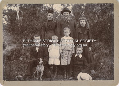 Eltham District Historical Society Inc
Photograph, Nicholes Photographers, Bird family, c.1905
Bird family, c.1905 Back row, L-R: Janet Bird (nee Kilpatrick), George Bird, Ellen May (Nell) Bird Front row L-R: George Hugh Bird, Ernest Reginald Bird, Arthur Andrew Bird, Edwin John Bird Nicholes Photographer, Alphington According to the Sands McDougall Melbourne Directory, George. Nicholes, Photographer was first listed on the north side of Heidelberg Road, Alphington in 1904 and again in 1905. By 1906 he was still listed but with no profession. From 1907 on he was listed as a bicycle agent. On July 23, 1878, George Bird married Janet Kilpatrick (born Ayrshire) at Northcote by Presbyterian minister, Duncan Fraser. The witnesses were daughters of the minister. George gave his profession as farmer. Around 1880 or possibly earlier he acquired the property known as View Hill at the top of Pitt Street, Eltham between Pitt Street and Mount Pleasant Road and what is now Eucalyptus Road. George and Janet developed an orchard and farm around the View Hill home and had 10 children, three of whom died young. George Bird is listed in the 1977 history of the Eltham Methodist Church as Steward and trustee in the early years. In the 1950 history he is mentioned as Sunday School Superintendent. In the early 1900s, Janet regularly went to the church by horse and jinker. Janet died September 2, 1915, age 60 of endocarditis and bronchial pneumonia. At about this time, three children had married (Sarah, George and Ada) and four were living at home. However, Edwin joined the AIF in August 1915 and Ellen married in 1916 leaving two sons, Arthur and Reg, to look after their father and the property although some of the married children may have lived at View Hill for some time. From Edwin's letters, Hilda Pepper, a cousin on their mother's side) stayed with the family for some time to help. In later years, George developed glaucoma and became blind. He died December 6, 1920, aged 75 years, of diabetes mellites. Both Janet and George are buried at Eltham Cemetery, but the gravestone incorrectly gives 1921 for the death of George. The estate was divided into equal portions and distributed to the surviving members with Arthur and Ted Pepper being Executors. Ada Janet Lowe received a portion above what is now Rockliffe Street and Sis Pepper (Sarah Ann nee Bird) the portion below Rockliffe Street. Ernest Pepper built in the 1930s on the Pepper block at the Pitt Street end. George's share was along Wattle Grove and Arthur received the portion at the eastern end. Presumably the other two received portions including the top of the hill and slopes down to Pitt Street, Mount Pleasant Road and Wattle Grove. Read's (at the corner of Pitt Street and View Hill Crescent) was the first additional house brought in on wheels by a Mr Walkenden. The View Hill house was occupied by the Johanssons in the 1930s and was later damaged by fire. Source: Info provided to Marg Ball by Neil and Lyn Pepper (both deceased) abt. 2018. PANEL 1875-1920 Panels began to be produced around 1875, and were particularly suited, because of their larger size, for capturing family, or even larger, groups. They measured 8.5 by 6.5 inches (22 cm x 16.5 cm). - Frost, Lenore; Dating Family Photos 1850-1920; Valiant Press Pty. Ltd., Berwick, Victoria 1991marg ball collection, 1905, arthur andrew bird, bird family, edwin john bird, ellen may (nell) bird, ernest reginald bird, george bird (1845-1921), george hugh bird, janet bird (nee kilpatrick), nicholes photographer alphington, straw boater -
 Eltham District Historical Society Inc
Photograph, Upper Yarra Dam, Spring Tour, 22 Oct 1995, 22/10/1995
EXPLORING THE UPPER YARRA (Newsletter No. 105, November 1995, by Bettina Woodburn) We enjoyed the Spring Excursion, this year "Exploring the Upper Yarra" - in spite of the constant rain and the countryside under the cloud cover, especially in the valleys, being mainly shiny shades of green. The occasional fields of buttercups, clumps of arum lilies and splendid rhododendron and other flowering bushes became very special. The Cobb and Co coach was warm and a cosy retreat as we zig-zagged on the highways and byways to glimpse the Yarra River, upstream and down, its secret places, and particularly the many bridges. Russell excelled as 'Poet Laureate', reading from Dacre Smyth's book. This 1979 publication includes paintings of all the bridges along the river with poems and brief descriptions of each one. Some of the bridges are in out of the way places and are not very well known. We looked forward to hearing the poetry as much as seeing the ' constructions'…Big Pat (was he short or tall, lean or fat? He did win the two hundred pound reward for discovering gold and had the creek named after him), about the 'Eddies'?, and the disliked 'meccano' bridge in Warburton, etc. etc. The hot roast lunch in the old Reefton Hotel was also most welcome. It was easy to imagine it peopled by miners and early settlers. Starting by crossing the new (1974) concrete bridge at Warrandyte we headed through Wonga Park with views to the Christmas Hills and to the escarpment of the Yering Gorge, which causes flood waters to back up through the Yarra Glen plain, so avoiding disasters downstream. At the end of a long driveway we found the wooden, privately owned Henley Bridge (1935 after the 1934 floods). This facilitates access to different parts of Henley Farm and to Lilydale. Everard Park, named after Blanche Shallard's father, a State Member for 17 years, below the Highway Yarra crossing was in need of care. It is 10 miles from Yarra Glen by road but, as "Yarra Marra” canoeists well know, 32 winding miles down by water. After more delightful countryside scenes we joined the Warburton Highway at Woori Yallock. From the old Railway Station at Launching Place the Centennial Trail for walkers, cyclists and ' horse riders has replaced the rails. The line from Lilydale was opened in 1901, and the last diesel freight train ran to Warburton in 1965. It continued to rain as we had morning tea in Warburton in a shelter between footbridges. From here we continued upstream past the Bridge to O'Shannasy Lodge and Reservoir, Starvation Creek, and the Peninsular tunnel (miners dug it as at Pound Bend) which we visited (scrambling down those steps!) on our return after lunch. Our furthermost point was the Upper Yarra Dam Reserve (and vast catchment area). Finished in 1957 after ten years work and 100 years after Yan Yean, it supplies much of Melbourne's water. After crossing the 30m Launching Place Bridge to the Eltham side of the Yarra and Healesville, we saw in the distance the Yarra Glen Timber Trestle Bridge over the river flats "the longest for years in the land it was said!" Harry's dream of "better weather over the Divide" unfortunately didn't come true, but I'm sure we 36 members will retain happy memories of a day that was wet and green and filled with Bridges. Bettina Woodburn - October 1995 Record of the Society's history of activities - Spring 1995 excursionColour photographshire of eltham historical society, activities, upper yarra dam, henley bridge -
 Eltham District Historical Society Inc
Photograph, Upper Yarra Dam, Spring Tour, 22 Oct 1995, 22/10/1995
EXPLORING THE UPPER YARRA (Newsletter No. 105, November 1995, by Bettina Woodburn) We enjoyed the Spring Excursion, this year "Exploring the Upper Yarra" - in spite of the constant rain and the countryside under the cloud cover, especially in the valleys, being mainly shiny shades of green. The occasional fields of buttercups, clumps of arum lilies and splendid rhododendron and other flowering bushes became very special. The Cobb and Co coach was warm and a cosy retreat as we zig-zagged on the highways and byways to glimpse the Yarra River, upstream and down, its secret places, and particularly the many bridges. Russell excelled as 'Poet Laureate', reading from Dacre Smyth's book. This 1979 publication includes paintings of all the bridges along the river with poems and brief descriptions of each one. Some of the bridges are in out of the way places and are not very well known. We looked forward to hearing the poetry as much as seeing the ' constructions'…Big Pat (was he short or tall, lean or fat? He did win the two hundred pound reward for discovering gold and had the creek named after him), about the 'Eddies'?, and the disliked 'meccano' bridge in Warburton, etc. etc. The hot roast lunch in the old Reefton Hotel was also most welcome. It was easy to imagine it peopled by miners and early settlers. Starting by crossing the new (1974) concrete bridge at Warrandyte we headed through Wonga Park with views to the Christmas Hills and to the escarpment of the Yering Gorge, which causes flood waters to back up through the Yarra Glen plain, so avoiding disasters downstream. At the end of a long driveway we found the wooden, privately owned Henley Bridge (1935 after the 1934 floods). This facilitates access to different parts of Henley Farm and to Lilydale. Everard Park, named after Blanche Shallard's father, a State Member for 17 years, below the Highway Yarra crossing was in need of care. It is 10 miles from Yarra Glen by road but, as "Yarra Marra” canoeists well know, 32 winding miles down by water. After more delightful countryside scenes we joined the Warburton Highway at Woori Yallock. From the old Railway Station at Launching Place the Centennial Trail for walkers, cyclists and ' horse riders has replaced the rails. The line from Lilydale was opened in 1901, and the last diesel freight train ran to Warburton in 1965. It continued to rain as we had morning tea in Warburton in a shelter between footbridges. From here we continued upstream past the Bridge to O'Shannasy Lodge and Reservoir, Starvation Creek, and the Peninsular tunnel (miners dug it as at Pound Bend) which we visited (scrambling down those steps!) on our return after lunch. Our furthermost point was the Upper Yarra Dam Reserve (and vast catchment area). Finished in 1957 after ten years work and 100 years after Yan Yean, it supplies much of Melbourne's water. After crossing the 30m Launching Place Bridge to the Eltham side of the Yarra and Healesville, we saw in the distance the Yarra Glen Timber Trestle Bridge over the river flats "the longest for years in the land it was said!" Harry's dream of "better weather over the Divide" unfortunately didn't come true, but I'm sure we 36 members will retain happy memories of a day that was wet and green and filled with Bridges. Bettina Woodburn - October 1995 Record of the Society's history of activities - Spring 1995 excursionRoll of 35mm colour negative film, 3 stripsKodak Gold 200-4shire of eltham historical society, activities, upper yarra dam, henley bridge -
 Eltham District Historical Society Inc
Photograph, Upper Yarra Dam, Spring Tour, 22 Oct 1995, 22/10/1995
EXPLORING THE UPPER YARRA (Newsletter No. 105, November 1995, by Bettina Woodburn) We enjoyed the Spring Excursion, this year "Exploring the Upper Yarra" - in spite of the constant rain and the countryside under the cloud cover, especially in the valleys, being mainly shiny shades of green. The occasional fields of buttercups, clumps of arum lilies and splendid rhododendron and other flowering bushes became very special. The Cobb and Co coach was warm and a cosy retreat as we zig-zagged on the highways and byways to glimpse the Yarra River, upstream and down, its secret places, and particularly the many bridges. Russell excelled as 'Poet Laureate', reading from Dacre Smyth's book. This 1979 publication includes paintings of all the bridges along the river with poems and brief descriptions of each one. Some of the bridges are in out of the way places and are not very well known. We looked forward to hearing the poetry as much as seeing the ' constructions'…Big Pat (was he short or tall, lean or fat? He did win the two hundred pound reward for discovering gold and had the creek named after him), about the 'Eddies'?, and the disliked 'meccano' bridge in Warburton, etc. etc. The hot roast lunch in the old Reefton Hotel was also most welcome. It was easy to imagine it peopled by miners and early settlers. Starting by crossing the new (1974) concrete bridge at Warrandyte we headed through Wonga Park with views to the Christmas Hills and to the escarpment of the Yering Gorge, which causes flood waters to back up through the Yarra Glen plain, so avoiding disasters downstream. At the end of a long driveway we found the wooden, privately owned Henley Bridge (1935 after the 1934 floods). This facilitates access to different parts of Henley Farm and to Lilydale. Everard Park, named after Blanche Shallard's father, a State Member for 17 years, below the Highway Yarra crossing was in need of care. It is 10 miles from Yarra Glen by road but, as "Yarra Marra” canoeists well know, 32 winding miles down by water. After more delightful countryside scenes we joined the Warburton Highway at Woori Yallock. From the old Railway Station at Launching Place the Centennial Trail for walkers, cyclists and ' horse riders has replaced the rails. The line from Lilydale was opened in 1901, and the last diesel freight train ran to Warburton in 1965. It continued to rain as we had morning tea in Warburton in a shelter between footbridges. From here we continued upstream past the Bridge to O'Shannasy Lodge and Reservoir, Starvation Creek, and the Peninsular tunnel (miners dug it as at Pound Bend) which we visited (scrambling down those steps!) on our return after lunch. Our furthermost point was the Upper Yarra Dam Reserve (and vast catchment area). Finished in 1957 after ten years work and 100 years after Yan Yean, it supplies much of Melbourne's water. After crossing the 30m Launching Place Bridge to the Eltham side of the Yarra and Healesville, we saw in the distance the Yarra Glen Timber Trestle Bridge over the river flats "the longest for years in the land it was said!" Harry's dream of "better weather over the Divide" unfortunately didn't come true, but I'm sure we 36 members will retain happy memories of a day that was wet and green and filled with Bridges. Bettina Woodburn - October 1995 Record of the Society's history of activities - Spring 1995 excursionRoll of 35mm colour negative film, 3 stripsKodak Gold 200-4shire of eltham historical society, activities, upper yarra dam, henley bridge