Showing 11745 items matching "palmyro-island"
-
 Flagstaff Hill Maritime Museum and Village
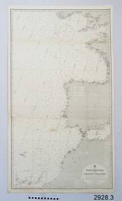
Document - Navigation Chart, Portsmouth to Canary Islands, Ca. 1928
This is an Official British Admiralty Navigation Chart, one of a set of 65 charts donated together with a wooden chart case. It was published and printed in London in 1928 by the British Admiralty. Navigation charts are drawn by professional hydrographers and describe the geography of land and water, enabling a water based navigator on board vessels such as ships to safely negotiate between ports locally and around the world. They are drawn to a particular standard with common symbols noting landmarks. The charts are used in conjunction with other navigational instruments and tools to calculate the vessel’s exact location and a safe route to its destination.The set of charts and their chart are of significance as examples of equipment and documents used to navigate the oceans of the world, particularly to Australia. Migration to Australia is an important part of this country's history.British Admiralty Navigation Chart - Portsmouth to Canary Islands - printed on rectangular white paper. Published in London by the British Admiralty in 1928.warrnambool, shipwreck coast, flagstaff hill, flagstaff hill maritime museum, flagstaff hill maritime village, chart, map, navigate, navigation, location, vessel, 1928, british admiralty, hydrographer, geography, admiralty chart, portsmouth, canary islands -
 Flagstaff Hill Maritime Museum and Village
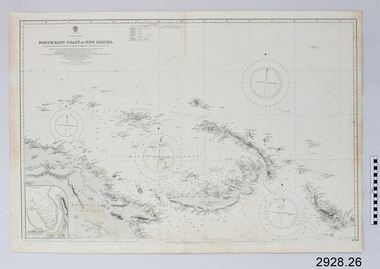
Document - Navigation Chart, North-East Coast of New Guinea with Bougainville, New Britain, New Ireland & Admiralty Islands
British Admiralty Navigation Chart - North-East Coast of New Guinea with Bougainville, New Britain, New Ireland & Admiralty Islandswarrnambool, shipwrecked-coast, flagstaff-hill, flagstaff-hill-maritime-museum, maritime-museum, shipwreck-coast, flagstaff-hill-maritime-village, shipwrecked-artefact, british admiralty navigation chart, navigation chart, new guinea, bougainville, north-east coast of new guinea, new britain, new ireland, admiralty islands -
 Flagstaff Hill Maritime Museum and Village
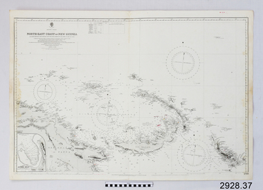
Document - Navigation Chart, North-East Coast of New Guinea
British Admiralty Navigation Chart - North-East Coast of New Guinea with Bouganville, New Britian, New Ireland and Admiralty Islandwarrnambool, shipwrecked-coast, flagstaff-hill, flagstaff-hill-maritime-museum, maritime-museum, shipwreck-coast, flagstaff-hill-maritime-village, shipwrecked-artefact, navigation chart, british admiralty navigation chart, british admiralty, new guinea -
 Phillip Island and District Historical Society Inc.
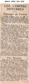
Newspaper clippings, 18/04/1938
Article in The Argus newspaper on 18/04/1938Article on a severe storm at Phillip Island which washed out campers, washed fishing boats ashore and wrecked the ferry ramp.local history, documents, newspapers, storms, phillip island, black & white newspaper clipping, phillip island storm -
 Phillip Island and District Historical Society Inc.
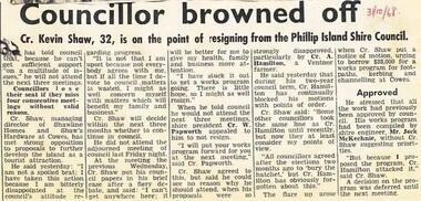
Newspaper Clipping, 31/10/1968
Newspaper clippings 1968Article reporting a threat by Cr Kevin Shaw to resign from Phillip Island Shire Council because of obstruction to his ideas.phillip island, phillip island shire council, cr kevin shaw -
 Phillip Island and District Historical Society Inc.
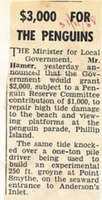
Newspaper Clipping, 31/11/1968
Article from a collection of newspaper clippings from October 1968 to July 1971Article about the Victorian Government offer of $2,000 to help restore damage to the beach and viewing platform at the Penguin Parade Phillip Island.phillip island, penguin beach, penguin parade, mr hamer -
 Queenscliffe Maritime Museum
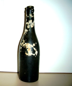
Bottle
Bottle recovered from wreck site of Joseph Sims - wrecked Prime Seal Island, Bass Strait 1/6/1930 -
 Port Fairy Historical Society Museum and Archives
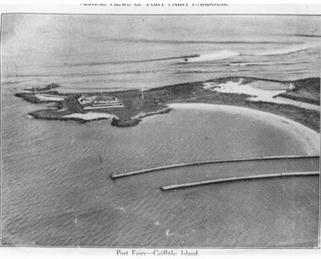
Photograph, C. 1925
Black and white arial photograph of the Moyne river entrance, the original signed by R.W.Golding.Black and white aerial photograph of Griffith island showing the lighthouse keeper’s compound, the large flagstaff and the river training walls in the foregroundHand written on the back "Port Fairy Moyne River Entrance R. W. Golding Handwritten on the back of the copy "Port Fairyb Harbour 1925"local history, photography, photographs, slides, film, arial, moyne river -
 Beechworth RSL Sub-Branch
Clothing - Hat Field Service, Go Fast Cap Peacekeeper- Bougainville, 1998 - 2003
Clothing article worn by Peacekeeping personnel on Operation Bel Isi Bougainville 1998 - 2003Clothing worn by Maj Damien Batty during his involvement with Operation Bel IsiYellow go-fast cap, featuring emblem of a dove holding an olive branch with the Island of Bougainville in the background with black text on the board Front - Peace emblem, embroidered- PEACE / OPERATION BELISI / Back - Embroidered - BOUGAINVILLE / Interior - In black marker - LT / BATTY / CHEclothing item -
 Bendigo Military Museum
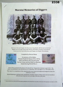
Memorabilia - Morotai - Memory of "Survey Corps" Diggers, Post 1945
.1) CD contains additional photos to compliment the 20 page written report. .2) Written report contains stories and photos of members of the Survey Corps and Air Force personnel based on Morotai during WWII. The photo in the report includes John K Nolan who went on to be Director of the Survey Corps 1972-1975.1) CD of photos. .2) Written report on some of the activities of the Survey Corps on the island of Morotai during WWII (20 pages).audio-visual technology-audio visual appliances, photography-photographs, documents, survey, royal australian survey corps, rasvy, morotai -
 Lakes Entrance Historical Society
Photograph - Star Fire, Hammarstrom Ian, 1990 c
Colour photograph of the catamaran fishing vessel Star Fire at Bullock Island fishing Co-op jetty Lakes Entrance Victoria ships and shipping, fishing industry, jetties -
 Lakes Entrance Historical Society
Photograph, 1950c
Black and white photograph of Bullock Island and rock groynes, Carpenter Town settlement at New Works, and the Entrance at Lakes Entrance, Victoriawaterways, dredging, islands -
 Buninyong & District Historical Society
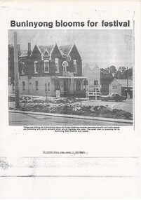
Photograph - Photocopy of cutting from The Courier, 11 Jan 1985 p9, photo of Crown Hotel, Photo Crown Hotel with floral plantings in traffic islands
buildingPhotocopy of newspaper report Crown Hotel with floral plantings in traffic islands, The Courier, Friday January 11, 1985 p.9.Article title; "Buninyong blooms for Festival"gold king festival, crown hotel -
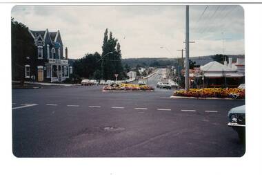 Buninyong & District Historical Society
Photograph - Colour photo, intersection Warrenheip and Learmonth Rds. during Gold King Festival, 1981, Intersection Warrenheip and Learmonth Rds. Buninyong, Gold King Festival, 1981
Events, buildingsColour photo, Intersection Warrenheip and Learmonth Rds. Buninyong, Gold King Festival, 1981, showing garden beds in traffic islandsgold king festival, corner warrenheip and learmonth -
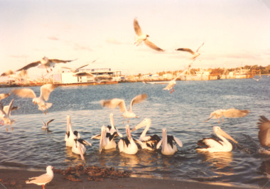 Lakes Entrance Historical Society
Photograph - pelicans and gullson waterfront, L E Tidy Town Committee, Lakes Entrance Victoria, 1990 c
Colour photograph showing pelicans and gulls being fed on waterfront opposite the Fishing Cooperative on Bullock Island Lakes Entrance Victoriabirdlife, waterways -
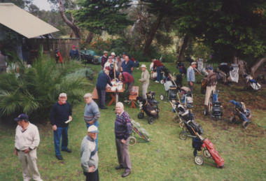 Lakes Entrance Historical Society
Photograph - Golf, Lakes Post Newspaper, 2001
number in album 03611.01Colour photograph group golfers called Ruthless and Toothless visit to Fraser Island before the first tee. Lakes Entrance Victoriagolf club, sports -
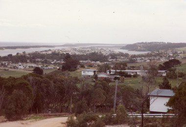 Lakes Entrance Historical Society
Photograph - Township
Colour photograph of township of Lakes Entrance showing North Arm, North Arm Bridge, Jemmys Point, Mount Barclay, Kalimna Heights, Cunningham Arm and sand dunes on left. Looking west to Bullock Island and Rigby Island. Photo taken from near Telecom Tower on Merrangbaur Hill. Lakes Entrance Victoria bridges, waterways, islands, township -
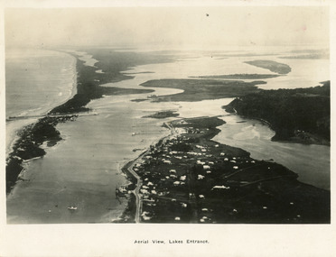 Lakes Entrance Historical Society
Postcard - Lakes Entrance, 1923c
Also large postcard 15 x 20|Also two mini postcard 6 x 9|Also copy black and white 9 x 14.5Black and white postcard of an aerial view of township of Lakes Entrance, showing western end of town, jetties and boat harbours in Cunninghame Arm, the entrance and piers, North Arm bridge, Bullock Island, Rigby, Fraser and Flannegan Islands, and a distant view of Boole Poole, Bunga Arm and Lake King. Lakes Entrance VictoriaAn aerial view showing position of Lakes Entranceaerial photograph, islands, waterways, topography, township -
 Bendigo Military Museum
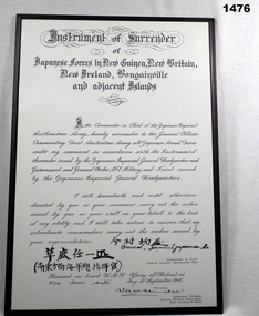
Certificate - CERTIFICATE OF SURRENDER MOUNTED, 6/9/1945
Copy of Instrument of Surrender of Japanese forces in New Guinea, New Britain, New Ireland, Bougainville and Adjacent islands 6th Sept 1945Signed by Vernon Sturdee, LT General First Australian Army and Commander in Chief Japanese Imperial Southeastern Army (signed in Japanese characters).documents-certificates, japan, military history, surrender -
 Flagstaff Hill Maritime Museum and Village
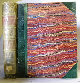
Book, A Descriptive Atlas of the Eucalypts of Australia
Warrnambool's Mechanics' Institute (or Institution as it was sometimes called) was one of the earliest in Victoria. On 17th October 1853 a meeting was held where it was resolved to request the Lieutenant Governor of the Colony to grant land for the erection of a Mechanics' Institutes building. A committee was formed at the meeting and Richard Osburne chaired the first meeting of this committee. The land on the North West corner of Banyan and Merri Streets was granted but there were no funds to erect the building. The Formal Rights of the Warrnambool Mechanics' Institute's encompassed its aims and these were officially adopted in1859; "This Institution has for its object the diffusion of literary, scientific, and other useful knowledge amongst its members, excluding all controversial subjects, religious or political. These objects are sought to be obtained by means of a circulating library, a reading room, the establishment of classes, debates, and the occasional delivery of lectures on natural and experimental philosophy, mechanics, astronomy, chemistry, natural history, literature, and the useful and ornamental arts, particularly those which have a more immediate reference to the colony." The Warrnambool Mechanics' Institute opened its first reading room in November1884 in the National School building at the corner of Banyan and Timor Streets. The Institute was funded by member subscription, payable on a quarterly, half yearly or yearly basis. Samuel Hannaford, the Manager of the Warrnambool Bank of Australasia, was the first Honorary Secretary of the Mechanics' Institutes, and an early President and Vice-President. He also gave several of the early lectures in the Reading Room. Another early Secretary, Librarian and lecturer was Marmaduke Fisher, the teacher at the National School. Lecture topics included The Poets and Poetry of Ireland', 'The Birth and Development of the Earth', 'The Vertebrae - with Remarks on the pleasures resulting from the study of Natural History' and 'Architecture'. In 1856 the Reading Room was moved to James Hider's shop in Timor Street, and by 1864 it was located in the bookshop of Davies and Read. In the 1860's the Mechanics' Institute struggled as membership waned but in 1866, after a series of fund raising efforts, the committee was able to purchase land in Liebig Street, on a site then called Market Square, between the weighbridge and the fire station. A Mechanics' Institute building was opened at this site in August 1871. The following year four more rooms were added to the main Reading Room and in 1873 the Artisan School of Design was incorporated into the Institute. The same year Joseph Archibald established a Museum; however it deteriorated when he was transferred to Bendigo in 1877. In 1880, with Archibald's return to Warrnambool, the Museum was re-established, and in 1885 a new building was built at the back of the Institute to accommodate the re-created School of Design, the Art Gallery and the Museum. In 1887 the Museum section was moved to the former court house in Timor Street (for some time the walls of the building formed part of the TAFE cafeteria but all is now demolished)). In 1911 the Museum was transferred back to the original building and the management of the Mechanics' Institute was handed over to the Warrnambool City Council. The Museum and Art Gallery became one and housed many fine works of art, and the Library continued to grow. The building was well patronised, with records showing that at the beginning of the 20th century there were between 500 and 800 visitors. During World War One the monthly figures were in the thousands, with 3,400 people visiting in January 1915. The Museum was a much loved Institution in Warrnambool until the contents of the Museum and Art Gallery were removed to make room for the Warrnambool City Council Engineers' Department. The contents were stored but many of the items were scattered or lost. When the original building was demolished the site became occupied by the Civic Centre, which included the new City Library. (The library was temporarily located in the old Palais building in Koroit Street.) In the process of reorganisation the Collection was distributed amongst the community groups: -The new City Library took some of the historic books and some important documents, historic photographs and newspapers. -The Art Gallery kept the 19th Century art collection and some of the artefacts from the museum. -The Historic Society has some items -The State Museum has some items -Some items were destroyed -Flagstaff Hill Maritime Village has old newspapers, Government Gazettes, most of the Mechanics' Institute Library, ledgers and documents connected to the Mechanics' Institute Library, some framed and unframed art works and some photographs. The Warrnambool Mechanics' Institute Library book collection is deemed to be of great importance because it is one of the few collections in an almost intact state, and many of the books are now very rare and of great value. A Descriptive Atlas of the Eucalypts of Australia and the adjoining Islands Author: Ferdinand Von Mueller Publisher: Government Printer Melbourne Date: 1879-1884 Label on spine cover with typed text RA 583.4 VONM Pastedown front endpaper has sticker from Warrnambool Mechanics Institute and Free Librarywarrnambool, shipwrecked-coast, flagstaff-hill, flagstaff-hill-maritime-museum, maritime-museum, shipwreck-coast, flagstaff-hill-maritime-village, shipwrecked-artefact, great ocean road, book, warrnambool library, warrnambool mechanics’ institute, mechanics’ institute library, victorian library board, warrnambool books and records, warrnambool children’s library, warrnambool public library, a descriptive atlas of the eucalypts of australia, a descriptive atlas of the eucalypts of australia and the adjoining islands, ferdinand von mueller -
 Phillip Island and District Historical Society Inc.
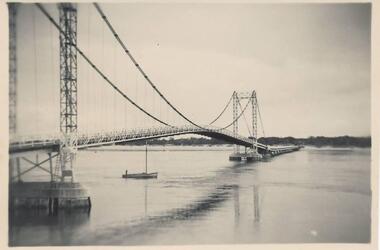
Photograph, Mid 20th Century
One of a collection of 9 photographs/postcards donated by F. WinnBlack & White photograph of the old Suspension Bridge linking San Remo and Newhaven, Phillip Island. Fishing boat sailing under the bridge.suspension bridge phillip island, bridge between san remo and phillip island, phillip island bridge, f winn -
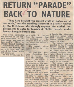 Phillip Island and District Historical Society Inc.
Newspaper Clipping, 28/11/1968
Article from a collection of newspaper clippings from October 1968 to July 1971Report of a letter by Mrs R Osborne to Phillip Island Shire Council criticising the actions of the Penguin committee and the concrete ramps they had built.phillip island, penguin parade, mrs r osborne, phillip island shire council -
 Glenelg Shire Council Cultural Collection
Postcard - Postcard - Casterton Island Park, c. 1946
SOURCED FROM CASTERTON TOWN HALL (FORMER SHIRE OF GLENELG) Sourced from Casterton Town Hall (Former Shire of Glenelg)Black and white photo postcard. Near Island Park, Casterton, during 1946 flood. Tractor towing horse float through floodwatersBack: Purple photographer's stamp. 'Postcard' in purple -
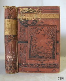 Flagstaff Hill Maritime Museum and Village
Book, The Fifth Continent
The Fifth Continent -with adjacent islands - Australia, Tasmania and New Guinea Author: Charles H Eden Publisher: Society for Promoting Christian Knowledge Label on spine with typed text R.S. 994.02 EDE Inside front cover has a sticker from Warrnambool Mechanics Institute and Free Library warrnambool, shipwrecked-coast, flagstaff-hill, flagstaff-hill-maritime-museum, maritime-museum, shipwreck-coast, flagstaff-hill-maritime-village, shipwrecked-artefact, book, warrnambool mechanics’ institute, the fifth continent, charles h eden -
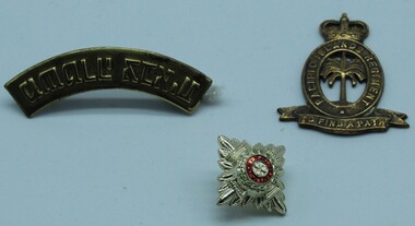 Ringwood RSL Sub-Branch
Badges
00524.1Pacific Island Regt collar badge queens crown 00524.2 Shoulder title brass with Indian writing 00524.3 Anodised officers pip -
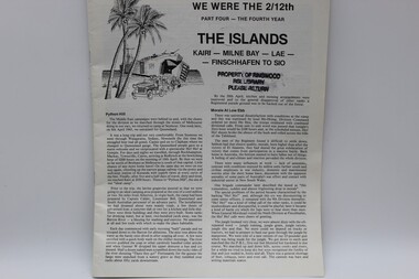 Ringwood RSL Sub-Branch
Document
Paper newsletter. We were the 2/12th. Part Four - The Fourth Year. The Islands Kairi - Milne Bay - Lae - Finschhafen to SIO. -
 Lakes Entrance Historical Society
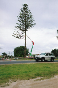
Photograph, 2000
Tree was a landmark during past Christmas and New Year festivities when it was decorated with coloured lights.|Also six other photographs showing various stages of removal of tree.Colour photograph showing the removal of the large Norfolk Island pine tree in the corner of the garden at 12 Roadknight Street, Lakes Entrance, Victoria.maintenance, gardens -
 Flagstaff Hill Maritime Museum and Village
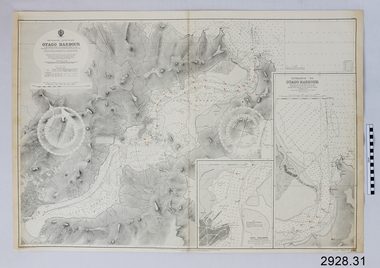
Document - Navigation Chart, British Admiralty, Otago Harbour, Late 19th to Early 20th century
Navigation charts are used by mariners around the world for navigating waterways. This chart was created for Otago Harbour in New Zealand. A ship "Otago' was named after this harbour and was once commanded by renowned maritime author Joseph Conrad. That ship now lies in Otago Bay, in the Derwent River, Tasmania.This navigation chart was published by the British Admiralty cartographer, to aid mariners to navigate the world's water bodies. Navigation charts are still used today, along with other navigational instruments.British Admiralty Navigation Chart - Otago Harbour, South Island, New Zealand. Chart shows insets with finer detail of important sections.warrnambool, shipwrecked-coast, flagstaff-hill, flagstaff-hill-maritime-museum, maritime-museum, shipwreck-coast, flagstaff-hill-maritime-village, shipwrecked-artefact, british admiralty navigation chart, navigation chart, british admiralty, otago harbour, south island, new zealand, otago bay, derwent river, tasmania, joseph conrad -
 Lakes Entrance Historical Society
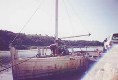
Photograph, Vera Bennett, Lady Harriet barge Lakes Entrance Victoria, 1992
Colour photograph of Lady Harriet barge moored at Bullock Island Jemmys Point in background, Also second photograph taken at different angle Pumping out stone barge 1992boats and boating, barges -
 Lakes Entrance Historical Society
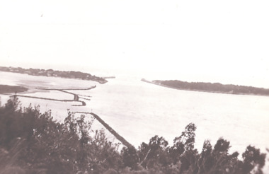
Photograph - View of Entrance from Jemmys Point, 1930 c
Black and white photograph of view of the entrance to the Gippsland Lakes from Jemmys Point showing end of Bullock Island Lakes Entrance Victoria waterways, islands, gippsland lakes