Showing 3604 items
matching street map
-
 Rutherglen Historical Society
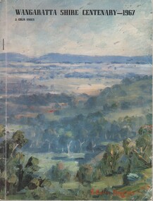
Book, J Colin Angus, A story of the districts included in the Shire of Wangaratta, 1967
Copy of book, autographed by the author, originally from the collection of Brian Jasper105 page book containing black and white illustrations, facsimilies, maps and portraits. Cover is printed in colour showing a painting of a forested landscape. Book presents the history of the Shire of Wangaratta on the occasion of its centenary in 1967.Autographed by the author on the inside of the front cover: "Colin Angus". At top of title page: "Brian S. Jasper"wangaratta shire, wangaratta council, centenary -
 Rutherglen Historical Society
Map, 1908
This is a map produced as part of a book entitled.. It is also stamped on the back in blue ink with an oval ring and the words North of England Institute. Newcastle. Mining & Meterolgical Faculty. Purchased on 23rd July 2017 by the Society after research by member Simon Killeen. Mining map of one of the first mines in Rutherglen area ( Chiltern West)Cream paper, black printing, rectangle with a drawingGeographical Survey of Victoria, Memoir, No6. Plate XX Plan of Underground Workings CHILTERN VALLEY CONSOLS MINE, RUTHERGLEN, PARISH OF CHILTERN WESTgold, rutherglen, mining, chiltern, underground mine map, geological survey, reef drives -
 Rutherglen Historical Society
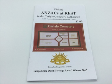
Booklet, David Valentine, Visiting ANZACs at Rest in the Caerlyle Cemetery, 15/4/2015
For thee 2015 Centenary of the Landing at GalipoliA self guided tour booklet for all to be able to locate the WWI Diggers buried in the Carlyle Cemetery. There are articles, letters and brief service descriptions including pre-service occupation, final rank, unit, casualty status, Places of service and date of discharge carlyle cemetery, anazc, wwi, self guided tour, war graves, map -
 Rutherglen Historical Society
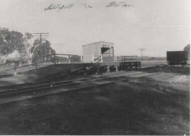
Image, Norman W. De Pomeroy, 1/07/1960
Black and white photograph of the Lilliput siding platform and stationWritten at top of photo: "Lilliput Railway Station: On back of photo: "Lilliput Siding - A solitary truck awaits loading. 1.7.1960" "Located at Map Ref 526 032" Rubber stamp: "Photographed by Norman W. De Pomeroy"railway stations, lilliput -
 Rutherglen Historical Society
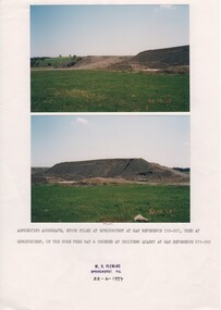
Image, W. H. Pleming, 13/10/1992
Two colour photographs printed on A4 paper with typed caption and a donor stamp. Date of photos in bottom right hand of each image.Date on images: "92-10-13" Caption below photos: "Asphelting aggregate stock piled at Springhurst at map reference 512-927, used at Springhurst on the Hume Free Way & crushed at Chiltern Quarry at map reference 671-969."hume freeway, chiltern quarry, road works -
 Rutherglen Historical Society
Image, 1980
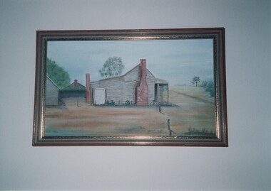
Colour photograph of a painting of a timber buildingWritten on back of photo: "Painted by O.J. Wood 1980 from original photo. Typed on back of photo: "Maddens Wine Hall, & Great Southern Post Office, & Coach Depot Circa 1910. | Located at Map-Ref' 536-074 | (Photo of painting of Mrs O.J. Wood, nee Olcorn)wood family, olcorn family, madden wine hall, great southern post office, coach depot -
 Rutherglen Historical Society
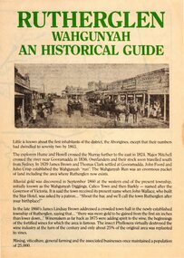
Pamphlet, Rutherglen Development Association, Rutherglen Wahgunyah: An Historical Guide, 1970s
Tourist brochure produced in the late 1970s by the Rutherglen Development Association with the assistance of Rutherglen Shire and Rutherglen Historical AssociationBrochure on A3 paper, folded in quarters, on pale yellow paper. Includes photographs, maps and a food and accommodation guide.rutherglen, wahgunyah, history, tourism -
 Rutherglen Historical Society
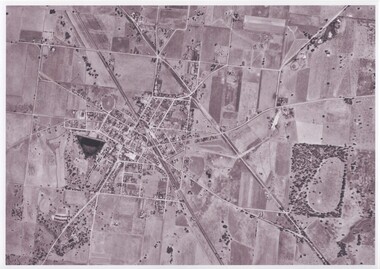
Map - Photocopy of an aerial photograph
Photocopy of an aerial photograph of Rutherglenaerial photographs, rutherglen -
 Rutherglen Historical Society
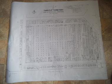
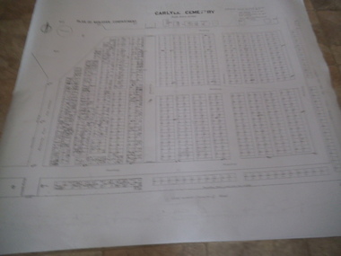
Carlyle Cemetery Map, Plan of Presbyterian Compartment, 1952
This is a map produced to attempt to bring order to the cemetery. Originally the layout was not well defined and it is difficult to use this plan to locate a particular grave, also the fact that not all graves are marked and foot paths are not defined has exacerbated this issue. Photocopy, White paper, black printing, black line work showing lot and compartment boundariesReferences Grid Survey points at 50 feet centres shown (as a cross with the reference mark number in brackets) Lot Number shown at left side of graves. Burial Number shown at right side of grave. Lots with unidentified burials show with dashed cross with in the lot. topographic survey, cadastral survey, carlyle cemetery, burials, graves, lot boundary, rotunda -
 Rutherglen Historical Society
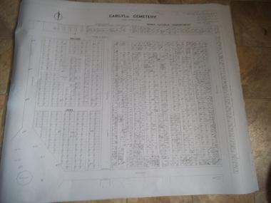
Carlyle Cemetery Map, Plan of Roman Catholic Compartment, 1952
This is a map produced to attempt to bring order to the cemetery. Originally the layout was not well defined and it is difficult to use this plan to locate a particular grave, also the fact that not all graves are marked and foot paths are not defined has exacerbated this issue. Photocopy, White paper, black printing, black line work showing lot and compartment boundariesReferences Grid Survey points at 50 feet centres shown (as a cross with the reference mark number in brackets) Lot Number shown at left side of graves. Burial Number shown at right side of grave. Lots with unidentified burials show with dashed cross with in the lot. topographic survey, cadastral survey, carlyle cemetery, burials, graves, lot boundary, rotunda -
 Rutherglen Historical Society
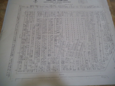
Carlyle Cemetery Map, Plan of Church of England Compartment, 1952
This is a map produced to attempt to bring order to the cemetery. Originally the layout was not well defined and it is difficult to use this plan to locate a particular grave, also the fact that not all graves are marked and foot paths are not defined has exacerbated this issue. Photocopy, White paper, black printing, black line work showing lot and compartment boundariesReferences Grid Survey points at 50 feet centres shown (as a cross with the reference mark number in brackets) Lot Number shown at left side of graves. Burial Number shown at right side of grave. Lots with unidentified burials show with dashed cross with in the lot. topographic survey, cadastral survey, carlyle cemetery, burials, graves, lot boundary, rotunda -
 Rutherglen Historical Society
Carlyle Cemetery Map, Plan of Wesleyan Compartment, 1952
This is a map produced to attempt to bring order to the cemetery. Originally the layout was not well defined and it is difficult to use this plan to locate a particular grave, also the fact that not all graves are marked and foot paths are not defined has exacerbated this issue. Photocopy, White paper, black printing, black line work showing lot and compartment boundariesReferences Grid Survey points at 50 feet centres shown (as a cross with the reference mark number in brackets) Lot Number shown at left side of graves. Burial Number shown at right side of grave. Lots with unidentified burials show with dashed cross with in the lot. topographic survey, cadastral survey, carlyle cemetery, burials, graves, lot boundary, rotunda -
 Rutherglen Historical Society
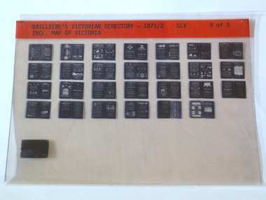
Microfiche, Bailliere's Victorian Directory 1871/2, 1871/72
A directory in Victoriasmall sheet of film SLV Incl. Map Of Victoriatown, names, victoria, map -
 Rutherglen Historical Society
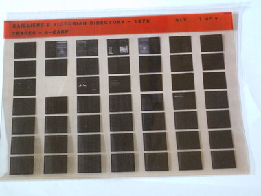
Microfiche, Bailliere's Victorian Directory 1875, 1875
A directory of Trades in Victoriasmall sheet of film SLV Trades - A - Carptown, names, victoria, map -
 Rutherglen Historical Society
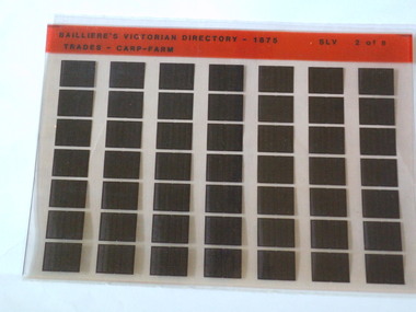
Microfiche, Bailliere's Victorian Directory 1875, 1875
A directory of Trades in Victoriasmall sheet of film SLV Trades - Carp Farmtown, names, victoria, map -
 Unions Ballarat
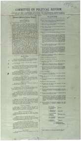
Printed report of the Committee appointed by the Congress to draft a scheme for political reform - the National Political Reform League, 1891
Political reform was high on the agenda of Australian Congress Committees. The report includes the preamble, rules and platform. Ballarat was chosen as the venue for the important 7th Intercolonial Trade Union Congress of Australia in April 1891 at which certain resolutions concerning political action by the workers were passed. The 7th Intercolonial Trades Union Congress in Ballarat is considered to be the beginnings of the Victorian Labor Party and mapped out 'One Big Union' which ultimately led to the formation of the ACTU.Relates to the history of the BTLC, political reform and other Australian Congress Committees - see 0019-26.Paperballarat trades hall, ballarat trades and labour council, political reform, australian congress committees, btlc, national political reform league, 7th intercolonial trades union congress, labor party - victoria, alp, one big union, actu -
 Dandenong/Cranbourne RSL Sub Branch
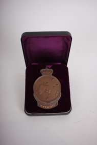
Medal - Medallion with original cardboard box, Unknown
WWI historic history.Bronze medallion presented to 2061 William Henry Elliott. Medallion is in commemoration of the men of ANZAC at GALLIPOLI in 1915 and in recognition of the great debt owed by all Australians. With the compliments of the Government of Australia. Medallion is round with a crown at the top.Cardboard box has typed address to Mrs L. Elliott, 59 Cleeland St, Dandenong from Central Army Records Office.W.H. Elliott. 1915 ANZAC. Simpson and his Donkey embossed at the back. Map of Australia and New Zealand with the stars of the Southern Cross embossed on the front. -
 Dandenong/Cranbourne RSL Sub Branch
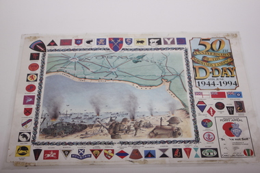
Poster, 50th Anniversary of the Normandy Landings D-Day 6th June 1944-1994, 1994
50th Anniversary of the Landing of the Battle of Normandy.Laminated poster with British WWII unit emblems displayed around the border. In the centre top is a drawn map of Normandy with a drawing of fighting on the shore of Normandy.In the right hand corner is an advertisement Proceeds to the Poppy Appeal with a drawn badge of the Royal British Legion.'Service not Self. -
 Dandenong/Cranbourne RSL Sub Branch
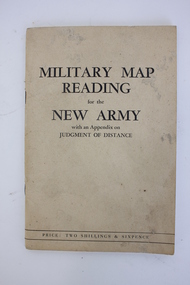
Booklet, Robertson & Mullens Ltd et al, Miltary Map Reading for the New Army with an Appendix on Judgment of Distance, 1941
... Dandenong/Cranbourne RSL Sub Branch 44 – 50 Clow Street ...Beige booklet bound with two staples. White pages within with black illustrations and type. 64 pages.Front: "MILITARY MAP / READING / for the / NEW ARMY / with an Appendix on / JUDGMENT OF DISTANCE / PRICE: TWO SHILLINGS & SIXPENCE"military map reading, orientation, navigation -
 Dandenong/Cranbourne RSL Sub Branch
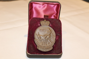
Medal - ANZAC 1915 Medalion, Unknown
WWI Historical significanceANZAC medallion with crown on top and Simpson and his donkey engraved on the medalion1915, ANZAC on one side with a map of Australia and New Zealand with the Southern Cross engraved on the other. The name E. Bourke is engraved on the bottom. -
 Dandenong/Cranbourne RSL Sub Branch
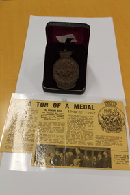
ANZAC Bronze medal, Commemorative Medal, UNKNOWN
SIMPSON AND DONKEY on face of medal. Map of AUSTRALIA / NEW ZEALAND together with Southern Cross on reverse.Heavy bronze medal dated 1915 ANZAC newspaper clipping reason or MedalAWARED TO R.V.FARKENS -
 Dandenong/Cranbourne RSL Sub Branch
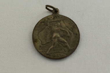
Medal - Victory Medal 1945
Circular Medal with suspension loop. The front of the medal shows a Knight with sword in front of an outline of Australia &1945, The back shows a map of the southern hemisphere showing Australia, Antarctica, New Zealand, South America & South Africa. At the top has words Victory Medal and the bottom manufacturers marking,Victory Medal 1945 -
 Dandenong/Cranbourne RSL Sub Branch
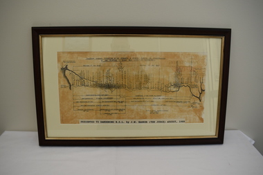
Map - Framed photograph, Diagram of Burma-Siam Railway
Major historical significance.Wooden framed photograph with diagram of the Railway. Illustrates the construction of the Railway. Began in October 1942 and completed on October 1943.Presented to Dandenong RSL by J. W. Barker (The Judge) August 1989. -
 Dandenong/Cranbourne RSL Sub Branch
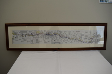
Map - Burma - Siam Railway
Is of Historical significance. This map was put together by T.R.Beaton on the 15th February 2002. He used old railway and road maps to show the route and it took him over 15 months to put together. T.R. Beaton was Manager/Curator of Australian Government Memorial Museum built above " Hellfire Pass " or Konyu Cutting.Framed picture map of the Burma _ Siam Railway. -
 Dandenong/Cranbourne RSL Sub Branch
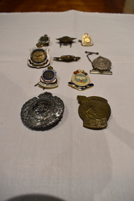
Badge - 10 assorted badges
Various Historical significance.Australian returned from active service badges. 2 x Returned Soldiers and Sailors Imperial League Badges. (1919 - 1947.) 2 x 1971 to 1990 Life Member Badges. Maralinga & Monte Bello Association Badge. Boomerang with Rising Sun badge. Royal Australian Engineers 1930 - 1942 badge. Silver badge "To the Women of Australia. Vintage Turkish Medal. Inscribed To The Women of Australia Crown surrounded by Laurel Leaves with Map of Australia in centre. Returned From Active Service. Two or Three Servicemen shown. RAAF #A1102 - 1942. Boomerang with Rising Sun below Crown. Royal Engineers Badge inscribed "FACIMUS ET FRANCIMUS" encircling GviR in centre Crown over Laurel leaves. -
 Dandenong/Cranbourne RSL Sub Branch
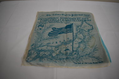
Memorabilia - Instrument of Surrender
Unconditional surrender of Japan. -
 Dandenong/Cranbourne RSL Sub Branch
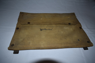
Functional object - Canvas document satchel
Canvas document folder with metal frame. Contents include maps of Gembrook ( Victoria ) and Shoalwater Bay ( Queensland ).Name inscribed on front " L . Chambers." -
 Dandenong/Cranbourne RSL Sub Branch
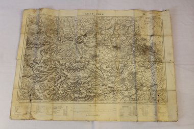
Map - Map of St Omer-France
... Dandenong/Cranbourne RSL Sub Branch 44 – 50 Clow Street ... -
 Dandenong/Cranbourne RSL Sub Branch
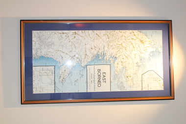
Print - Map of East Borneo
... Dandenong/Cranbourne RSL Sub Branch 44 – 50 Clow Street ... -
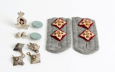 Ringwood RSL Sub-Branch
Uniform, Australian Army Nurse, K.G.Luke buttons, Circa 1950 and 1960
Royal Australian Army WRAAN Corps. 00066 .1 Silver buttons made by K.G.Luke Melbourne Kings crown & map of Australia 1 centremetre x 2 00066.2. Hat badge, Queens crown, white metal, slider fitting. 00066.3 Buttons, grey felt covered, 2 centremeters x2 00066.4 Officers shoulder pips, white metal & enamel. 00066.5 Cloth shoulder boards with maroon officers pips, cut off uniform 10 x 5 centremeters plus buttons x 2