Showing 2851 items matching "wests road"
-
 Bendigo Historical Society Inc.
Photograph - MINING IN BENDIGO COLLECTION: MINING PHOTOGRAPHS
BHS CollectionFolded paper with copies of photos of mines and various mining buildings. On the front is a view from New Chum Hill, looking south in 1890's. Pictured is the Lazarus Crushing Plant and boiler house, Lansell's '222'. Amd the new Chum Mines in the background. On the inside at the top is the New Chum Railway, Golden Square. Pictured is the mine and its buildings, two chimneys, two large wood stacks and other mines in the background. On the left, a man is standing on the side of the railway line beside the mine. The next picture is the United Hustlers and Redan Mine, west of Comet Hill State School, Sandhurst Road. It shows the mine and its buildings, chimney, ore bins, mullock heap and tramway. The middle picture is the Central Deborah, Violet Street, near Bendigo Creek, Golden Square. It shows the poppet legs, buildings and some machinery behind the large building. The large building has eight ventilators in the roof. The buildings are made of corrugated iron. The bottom left picture is the Deborah Mine, Quarry Hill. The picture shows the poppet legs on the hilltop, the buildings beside it, a square chimney behind the poppet legs and some vegetation and a peppercorn tree in the foreground. The far building also has ventilators in the roof. The picture on the right is underground at 1000 feet level in the Deborah Mine. Pictured are three men with a rock drill. On the back, at the top is a picture of a First Motion Winding Engine at Deborah - later at Central Deborah. The picture shows the engine and driver. The middle picture is the South New Moon Mine, Eaglehawk - leading mine in State in 1903. The picture shows the poppet legs, buildings, chimney and a high tramway. In the foreground is a dam. The bottom picture is Victoria Hill looking south to New Chum Hill. In the foreground is Lansell's '180' Mine and Ballerstedt's Open Cut and in the background are the 'New Chum and Victoria', 'Old Chum' and the 'North Old Chum'.photo, mining in bendigo, mining photographs, lazarus crushing plant, lansell's 222, new chum mines, new chum railway, united hustlers and redan mine, comet hill state school, central deborah, deborah mine, first motion winding engine, south new moon mine, lansell's 180, ballerstedt's open cut, new chum and victoria, old chum, north old chum, square chimney -
 Federation University Historical Collection
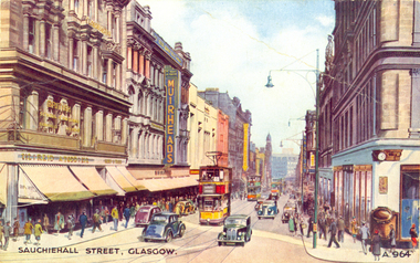
Postcard - colour, Sauchiehall Street, Glasgow
auchiehall Street /ˈsʌxihɔːl/ is one of the main shopping/business streets in the city centre of Glasgow, Scotland. Along with Buchanan Street and Argyle Street, it forms the main shopping area of Glasgow, containing the majority of Glasgow's high street and chain stores.[1] Although commonly associated with the city centre, Sauchiehall street is over 11⁄2 miles (2.5 km) long, finally meeting Argyle Street in the West End, in front of the Kelvingrove Museum, where they form Dumbarton Road which continues through Partick. The two streets run parallel through the city centre, before starting to conjoin westward of the M8 motorway at Charing Cross. (Wikipedia)Colour postcard of a street with cars, double decker buses and four storey buildings. The street is Sauchiehall Street, Glasgow, Scotland.chatham-holmes family collection, glasgow, scotland, double decker bus -
 Federation University Historical Collection
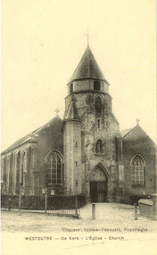
Postcard - black and white, Westoutre Church, France, c1917
Westouter Churchyard and Extension is located 12 Kms south-west of Ieper town centre, on a road leading from the N375 Dikkebusseweg. The village of Westoutre (now Westouter) remained in Allied hands from the early months of the First World War to the Armistice, but in the summer of 1918, after the Battles of the Lys, it was within 2.4 Kms of the front line. The Churchyard and Extension was used by field ambulances and fighting units at intervals from November 1914 to September 1918. It contains 98 Commonwealth burials of the First World War and three German graves.(http://www.ww1cemeteries.com/ww1cemeteries/westouterchurchyardandextension.htm, accessed 11/07/2014) The only Australian buried at the Westoutre churchyard and extension is Gunner J. GRANT (2420) 30/09/1917 Australian Heavy Artillery Australian II. F. 12. (http://www.ww1cemeteries.com/ww1cemeteries/westouterchurchyardandextension.htm, accessed 11/07/2014)A WW1 Australian soldier's memorabiliaBlack and white postcard of a church at WestoutreUitgever: Sansen-Vannest, Poperinghe Westoutre - De Kerk - L'Eglise - Churchwestoutre, westouter, chatham-holmes family collection, france, church -
 Flagstaff Hill Maritime Museum and Village
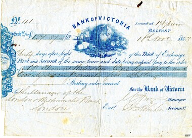
Currency - Banknote Belfast, Bank of Victoria, 1853
The promissory note issued at Belfast, now Port Fairy, Victoria by the “Bank of Victoria” is an early example of currency issued by a private bank. This note was issued in 1853 the same year that the bank commenced business in Belfast. Details of the first production of a banknote backed by the Australian Government occurred on 1 May 1913 following the "Australian Notes Act of 1910" (Australian National Museum). The first building the Bank of Victoria purchased in Belfast was of timber and later sold. Smith & Watts Architects advertised for tenders in the Melbourne Argus on Thursday 29/4/1869 for the erection of a substantial building that is now occupied by Moyne Shire Council in Cox Street. A meeting of the Directors of the Bank of Victoria elected on 1 October 1852. A ballot took place for four directors resulting in Wm. Highett Esq. Wm F. Splatt, Esq. M.L.C., Alex. Wilson, Esq. and W.H. Tuckett” elected as Directors. It was reported from a later meeting in “The Argus” Melbourne on 3 August 1853 that a branch had opened in Swanston Street, Melbourne on 3rd January 1852 with Henry Miller as Chairman of the Board and J. Matheson as the Manager; followed by Geelong on 12 August 1852. Then at the request of “influential inhabitants”, the Belfast branch commenced on 11 May 1853, which had “already met with very general support and encouragement”. This was a colonial bank at the time of vast pastoral runs and gold speculation – how "Mr Thomas [....ton?]" came by his fortune of One Hundred and Twenty-Seven Pound and five shillings can only be wondered at until further research reveals the story. This promissory note records the early colonial system of banking and reflects the economic growth and entrepreneurship of the South West Region of Victoria.Banknote of fine paper. There is a fold multi-crease down the centre top to bottom, lighter creasing across the top and angular creasing to the bottom left and right-hand corners. Yellow spotting is visible across the object breaking through the grey blue colour of the paper. A dark ink blot appears near the top right-hand corner. The left-hand side of the banknote is uneven. The back of the document has darker spotting, a used dirty look patina and some insect spotting. Horizontal crease markings can be seen creating quarter marks. The front of the banknote reads: "No.41/ Exch.ge for £127.57- Bank of Victoria/Issued at 1% prem/Thirty days after Sight of this Third of Exchange/First and Second of the same tenor and date being unpaid pay to the order of/Mr. Thomas [Raliston?]/One hundred and twenty seven pounds five shillings Sterling silver received/To the Manager of the London Westminister Bank London/for the Bank of Victoria [signed?] Manager/Ent.d [?] Robertson Account.t. The blue printed Bank of Victoria logo features a world globe, sailing ships, wool bails, sheep, colonial building and mining tools. flagstaff hill, warrnambool, maritime village, maritime museum, flagstaff hill maritime museum and village, shipwreck coast, great ocean road, promissory notes, bank notes, bank of victoria, smith & watts, smith & watts architects, 1853, william highett, william f. splatt, alex wilson, w.h. tuckett, henry miller, money miller, belfast (now port fairy) -
 Federation University Historical Collection
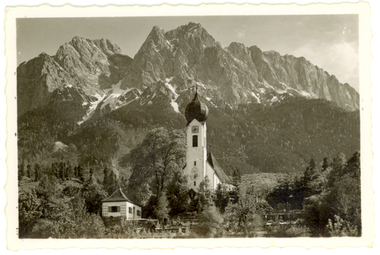
Photograph - Photograph - Black and White, Church at Garmisch-Partenkirchen, Bavaria, Germany
Garmisch (in the west) and Partenkirchen (in the east) were separate German towns for many centuries, and still maintain quite separate identities. Partenkirchen originated as the Roman town of Partanum on the trade route from Venice to Augsburg and is first mentioned in the year A.D. 15. Its main street, Ludwigsstrasse, follows the original Roman road. (Wikipedia)A church stands before large mountains in Garmisch-Partenkirchen, Bavaria, Southern Germanychatham family collection, garmisch-partenkirchen, bavaria, germany, church, alps -
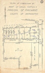 Ringwood and District Historical Society
Map, Plan of Subdivision - Part of Crown Portion 3, Parish of Ringwood, County of Mornington (Undated, circa 1930s)
Hand-drawn map of subdivided allotments in Molan Street and New Street Ringwood, south of railway line.Real estate sales notations on some allotments possibly added post decimal currency changeover date, 1966. Weatherboard shop marked on south-west corner of New Street and Whitehorse Road. -
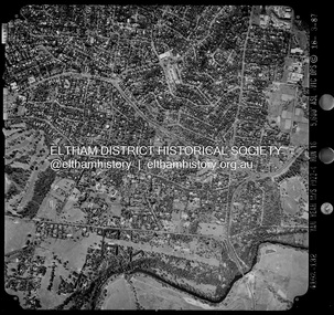
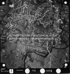 Eltham District Historical Society Inc
Photograph - Aerial Photograph, Landata, Montmorency / Lower Plenty, Jan. 1962
Centred on 147 Old Eltham Road, Lower Plenty bounded by Hurstbridge Railway Line to north, Yarra River to south, Main Road, Eltham to east and Heidelberg Golf Club to west. Historic Aerial Imagery Source: Landata.vic.gov.au Aerial Photo Details: Project No : 539 Project : MELBOURNE-GEELONG PROJECT Run : 6 Frame : 81 Date : 01/1962 Film Type : B/W Camera : RC5 Flying Height : 6000 Scale : 15840 Film Number : 1524 GDA2020 : 37°43'52"S, 145°07'26"E MGA2020 : 334685, 5822354 (55) Melways : 21 D9 (ed. 42)aerial photo, lower plenty, main road, montmorency, phoebe mason collection, eltham, eltham lower park, heidelberg golf club, hurstbridge railway line, main road eltham, yarra river -
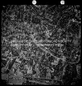
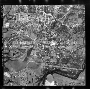 Eltham District Historical Society Inc
Photograph - Aerial Photograph, Landata, Montmorency / Lower Plenty, Feb. 1956
Centred on 20 Panorama Avenue, Lower Plenty bounded by Rattray Road to north, Yarra River to south, Bolton Street to east and Heidelberg Golf Club to west. Historic Aerial Imagery Source: Landata.vic.gov.au Aerial Photo Details: Project No : 250 Project : MELBOURNE OUTER SUBURBS PROJECT Run : 16A Frame : 53 Date : 02/1956 Film Type : B/W Camera : EAG9 Flying Height : 10000 Scale : 12000 Film Number : 1187 GDA2020 : 37°43'47"S, 145°07'25"E MGA2020 : 334645, 5822519 (55) Melways : 21 D9 (ed. 42)aerial photo, lower plenty, main road, montmorency, phoebe mason collection, bolton steet, heidelberg golf club, rattray road -
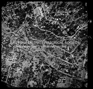 Eltham District Historical Society Inc
Photograph - Aerial Photograph, Landata, Montmorency / Lower Plenty, Jan. 1973
Centred on 385 Main Road, Lower Plenty bounded by Grand Boulevard, Montmorency to north, Old Eltham Road to south, Bolton Street to east and Panorama Avenue to west. Historic Aerial Imagery Source: Landata.vic.gov.au Aerial Photo Details: Project No :1043 Project : MONTMORENCY Run : 2 Frame : 124 Date : 01/1973 Film Type : B/W Camera : RC8 Flying Height : 2200 Scale : 4000 Film Number : 2722 GDA2020 : 37°43'48"S, 145°07'49"E MGA2020 : 335243, 5822507 (55) Melways : 21 E9 (ed. 42)aerial photo, lower plenty, main road, montmorency, phoebe mason collection, bolton steet, grand boulevard, old eltham road, panorama avenue -
 Eltham District Historical Society Inc
Photograph - Aerial Photograph, Landata, Montmorency / Lower Plenty, Mar. 1987
Centred on 354-356 Main Road, Lower Plenty bounded by Rattray Road, Montmorency to north, Yarra River to south, Falkiner Street, Eltham to east and Lower Plenty shops to west. Historic Aerial Imagery Source: Landata.vic.gov.au Aerial Photo Details: Project No :1716 Project : WESTERN PORT FORESHORES Run : 16 Frame : 132 Date : 03/1987 Film Type : B/W Camera : RC10 Flying Height : 5600 Scale : 10000 Film Number : 4102 GDA2020 : 37°43'51"S, 145°07'38"E MGA2020 : 334968, 5822406 (55) Melways : 21 E9 (ed. 42)aerial photo, lower plenty, main road, montmorency, phoebe mason collection, eltham, eltham lower park, falkiner street, lower plenty shops, main road eltham, rattray road, yarra river -
 Eltham District Historical Society Inc
Photograph - Aerial Photograph, Landata, Montmorency / Lower Plenty, Nov. 1975
Centred on 328 Main Road, Lower Plenty bounded by Rattray Road, Montmorency to north, Rosehill Road to south, Falkiner Street to east and Lower Plenty shops to west. Historic Aerial Imagery Source: Landata.vic.gov.au Aerial Photo Details: Project No :1243 Project : (ALSO A.P. 1227) Run : 24A Frame : 146 Date : 11/1975 Film Type : B/W Camera : RC8 Flying Height : 5000 Scale : 10000 Film Number : 2722 GDA2020 : 37°43'40"S, 145°07'32"E MGA2020 : 334820, 5822743 (55) Melways : 21 D8 (ed. 42)aerial photo, lower plenty, main road, montmorency, phoebe mason collection, eltham lower park, falkiner street, lower plenty shops, rattray road, rosehill road -
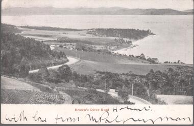 Bendigo Historical Society Inc.
Postcard - Australia, Elliot Collection, 1895 - 1914
Thought to have originated in Austria in 1869, postcards first gained popularity in Australia in the 1890s.They were used to send short messages to friends and family. This collection was generated by Mary Emma Elliot of Talgarno. Talgarno is a rural locality in Victoria, Australia, situated on the southern shoreline of Lake Hume, about 23 km east of Albury-Wodonga. The collection contains postcards from across the world. Mary Emma Sibley was born in Ironbark, Bendigo in 1859. She married James Elliot in 1893 and they settled at “Kelso”, Talgarno. They had two children – Mona and Sibley. Mary Emma Elliot died in Melbourne in 1944, aged 84 years. Australian postcards collected by Mrs. James Elliot between 1898 and 1915. 1405.281 Brown's River Road (Copy No 2) 1405.282 New Norfolk 1405.283 Road Scene near Weldborough, N. E. Coast, Tasmania 1405.284 West Burnie. Tasmania 1405.285 General Post Office, Hobart 1405.286 Above the Rapids, Gordon River, Tasmania 1405.287 St. Patrick's River and Fisherman's Hut. Tasmania 1405.288 Cataract Gorge 1405.289 Cataract Gorge, Launceston 1405.290 Silver Falls, Mt. Wellington, Tasmania 1405.291 A Famous Tourists Resort. Mount Roland and Mount Claude near Sheffield. Tas 1405.292 Picturesque Tasmania 1405.293 Fem Scene - Lobster Creek - near Ulverstone. Tas 1405.294 St. Mary's Pass. East Coast. Tasmania 1405.295 Huonville. Tasmania 1405.296 Russell Falls 1405.297 Government House, Hobart 1405.298 Christ Church, Longford, Tasmania 1405.299 Port Arthur 1405.300 Launceston. Pulpit Rock, Corra Linnpostcards, collecting, collections, talgarno -
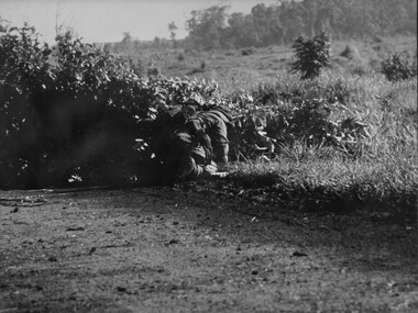 National Vietnam Veterans Museum (NVVM)
Photograph, Gibbons, Denis, Clearing Road Block
Denis Gibbons (1937 – 2011) Trained with the Australian Army, before travelling to Vietnam in January 1966, Denis stayed with the 1st Australian Task Force in Nui Dat working as a photographer. For almost five years Gibbons toured with nine Australian infantry battalions, posting compelling war images from within many combat zones before being flown out in late November 1970 after sustaining injuries. The images held within the National Vietnam Veterans Museum make up the Gibbons Collection.A black and white photograph of an Australian Engineers crawls around a road block constructed by VietCong across the National Highway North West of the Province capital Baria. Once the charges and mines were isolated, the Engineer cleared the obstruction and reopened the roadphotograph, nva/vc, engineers, baria, gibbons collection catalogue, viet cong, national highway, province, land mines, denis gibbons -
 Ringwood and District Historical Society
Photograph, Taken from Eastland access road looking south-west, on 21 April 2009. Showing library and pedestrian walk and crossing
... Taken from Eastland access road looking south-west, on 21... Eastland access road looking south-west, on 21 April 2009. Showing ...Ron Brons photographic study of Ringwood. -
 Bendigo Historical Society Inc.
Photograph - Nell Gwynne Gold Mine site, 1934
The Nell Gwynne mine site was within the Spring Gully Water Reserve, north west of the reservoir near Diamond Hill Road. An abridged prospectus for the Nell Gwynne (B.M.L.) No Liability, was published in the Sun News Pictorial on 7th June 1934, page 26 (Advertising).https://trove.nla.gov.au/newspaper/article/277316940?searchTerm=napoleon%20bmlSignificant to mining history of Bendigo.Black and white photograph of two weatherboard houses in bush setting. Gravel road in foreground. Written in pencil on back of photograph in pencil: 'Nell Gwynne 25.9.34'nell gwynne gold mine -
 Eltham District Historical Society Inc
Document - Property Binder, 1570 Main Road, Research
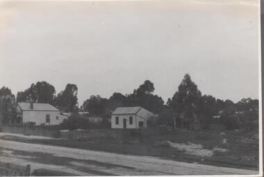
Typed sheets (2 pages): History of Research State School No. 2959, Principal F P Sheehan, historian M Allwood,main road, property, houses, shops, businesses, research (vic.), research state school no. 2959, caledonian gold field, swiper's gully, wallaby town, research gully, discovery gold plenty ranges, fountain of friendship hotel, ray morris, alice russell, norma family, bettison family, reynolds family, william west, joseph m makey, henry james cole, mary jane rodda, florissa milton, f p sheehan, m allwood, research hotel -
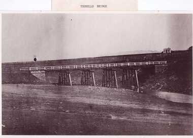 Clunes Museum
Photograph, PURCELL, ROGER, 1994
ORIGINAL PHOTOGRAPH OWNED BY MRS. LENA COOK OF CASTLEMAINE RD. CRESWICK.. THE PHOTOGRAPH WAS TAKEN LOOKING SOUTH WEST, THE SMALL COTTAGE SOUTH EAST OF HOLDING KNOWN AS 'STRAINS' ON THE CORNER OF BALLARAT AND COOK'S ROADS, MAY HAVE BEEN THE TOLL HOUSE. A WELL BESIDE THE COTTAGE IS STILL NEAR THE ROAD. BESIDE THE NEW TOURELLO BRIDGE..1 FRAMED PHOTOGRAPH OF TOURELLO BRIDGE ON BALLARAT RD. OVER COGHILLS CREEK. .2 BLACK & WHITE PHOTOGRAPH (COPY) .3 BLACK AND WHITE COPY OF ABOVE PHOTOGRAPHlocal history, photography, photographs, bridges -
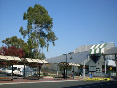
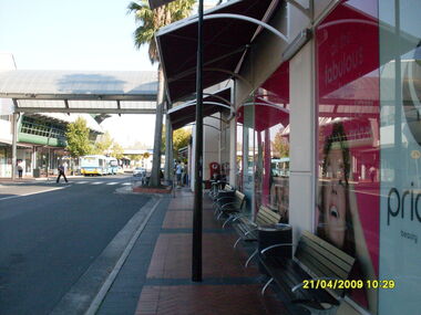
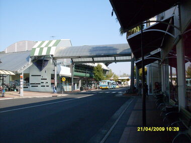 Ringwood and District Historical Society
Photograph, Eastland access road looking west, on 21 April 2009. Showing library on left, shops on right and car overpass. Also Ventura buses and pedestrian crossing to Eastland
... Eastland access road looking west, on 21 April 2009... road looking west, on 21 April 2009. Showing library on left ...Ron Brons photographic study of Ringwood. -
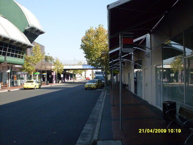 Ringwood and District Historical Society
Photograph, Eastland access road looking west, on 21 April 2009. Showing library on left, shops on right and car overpass
... Eastland access road looking west, on 21 April 2009... road looking west, on 21 April 2009. Showing library on left ...Ron Brons photographic study of Ringwood. -
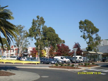
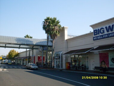 Ringwood and District Historical Society
Photograph, Looking along Eastland access road looking west, on 21 April 2009. Showing entrance to Eastland, cafe and Big W store
... Looking along Eastland access road looking west, on 21... Eastland access road looking west, on 21 April 2009. Showing ...Ron Brons photographic study of Ringwood. -
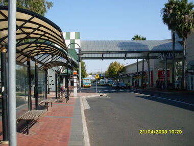 Ringwood and District Historical Society
Photograph, Looking along Eastland access road looking west, on 21 April 2009. Showing bus stop and entrance to Eastland
... Looking along Eastland access road looking west, on 21... Eastland access road looking west, on 21 April 2009. Showing bus ...Ron Brons photographic study of Ringwood. -
 Ringwood and District Historical Society
Photograph, Looking along Eastland access road looking west, on 21 April 2009. Showing pedestrian crossing
... Looking along Eastland access road looking west, on 21... Eastland access road looking west, on 21 April 2009. Showing ...Ron Brons photographic study of Ringwood. -
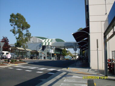
 Ringwood and District Historical Society
Photograph, Looking along Eastland access road towards the south-west, on 21 April 2009. Showing pedestrian crossing to south car park and shops
... Looking along Eastland access road towards the south-west... Eastland access road towards the south-west, on 21 April 2009 ...Ron Brons photographic study of Ringwood. -
 Ringwood and District Historical Society
Photograph, Looking along Eastland access road towards the west, on 21 April 2009. Showing pedestrian crossing to south car park
... Looking along Eastland access road towards the west, on 21... Eastland access road towards the west, on 21 April 2009. Showing ...Ron Brons photographic study of Ringwood. -
 Phillip Island and District Historical Society Inc.
Booklet, Cowes McRae Beach Estate, 1960s
This land was owned by the McRae family, whose wife was a Justice. Hence the street names of McRae and Justice. The weatherboard family home [ originally a guest house called Glen Isle] was at the end of the current Justice Road. The estate was created in the mid 1960s. The house was put on skids and dragged by two tractors and a bulldozer to 364 Church Street while the family home was built at 368 Church Street, Cowes.[ Source Sandra Rocotas, nee McCrae. Facebook Community Noticeboard 5/2/2023. Permission given to use information and photos ] Estate was sold by Rogan Real Estate.HistoricalColoured A4 brochure describing the McRae Beach Estate, including plan of streets and location on Island, photos and description of the Island. Sold by Rogan Real Estate.Cowes McRae Beach Estate - Right in the heart of things .Phillip Island - The Loveliest Isle on Earthhousing, justice family, mcrae family, cowes west, rogan real estate cowes phillip island, glen isla -
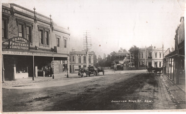 Melbourne Tram Museum
Photograph - Kew Junction looking South West - horse tram, c1900
Photograph, from a postcard titled "Junction High St Kew." shows a horse tram at Kew Junction in Church St about to turn into High St. Buildings in the view are F O Stowe Fruiter Confectioner, Alice cycle works, a tobacconist advertising Havelock tobacco sign, and Collins Kew Hotel. There are three horse-drawn carts, one with a horse eating from a chaff bag.Yields information about Kew Junction c1900.Black and white photograph with notes on the rear.Has on the rear in pencil "Horse tram in Barker Road Kew" and number "185"tramways, horse trams, kew junction, high st kew, church st -
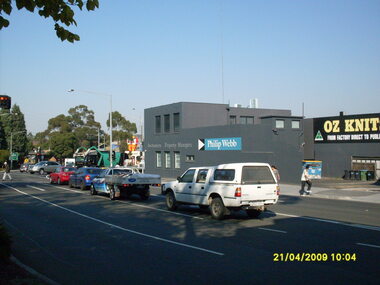 Ringwood and District Historical Society
Photograph, Corner of Maroondah Highway and Ringwood Street looking south, Ringwood on 21 April 2009. Ozknit and Phillip Webb Real Estate on west side of road
... Estate on west side of road.... April 2009. Ozknit and Phillip Webb Real Estate on west side ...Ron Brons photographic study of Ringwood -
Canterbury History Group
Photograph - Canterbury Road looking west
... Canterbury Road looking west... Road looking west ...Circa 1900; copied from Camberwell Library collection Black and white photographcanterbury mansions, horse and carriages, hotels, canterbury post office, street trees -
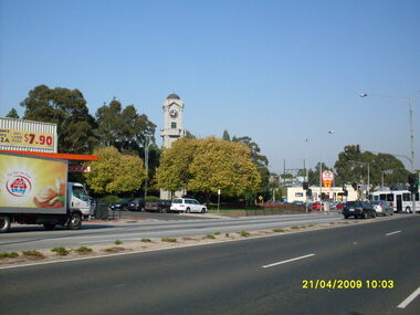 Ringwood and District Historical Society
Photograph, Corner of Maroondah Highway and Wantirna Road looking south-west, Ringwood on 21 April 2009. Memorial Clocktower, Haymes Paint and Johnny Boys Pizza
... Corner of Maroondah Highway and Wantirna Road looking south... of Maroondah Highway and Wantirna Road looking south-west, Ringwood ...Ron Brons photographic study of Ringwood -
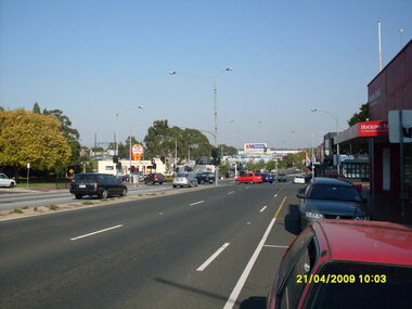 Ringwood and District Historical Society
Photograph, Corner of Maroondah Highway and Wantirna Road looking west, Ringwood on 21 April 2009
... Corner of Maroondah Highway and Wantirna Road looking west... of Maroondah Highway and Wantirna Road looking west, Ringwood on 21 ...Ron Brons photographic study of Ringwood