Showing 6699 items
matching river
-
 Greensborough Historical Society
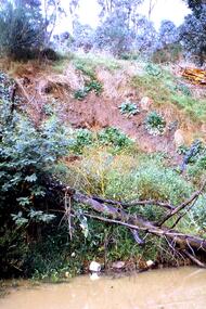
Slide - Photograph, John Ramsdale, Poor riverbank management: Slide 62, 1990s
Photograph shows poor riverbank management along the banks of the Plenty River.Part of the John Ramsdale collection of slides and audio visual material.Colour photograph scanned from slide.No maker's marks. No caption on slide.plenty river -
 Greensborough Historical Society
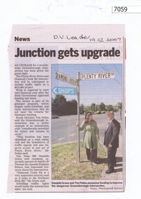
Newspaper Clipping, Junction gets upgrade, 19/12/2007
Article on the upgrade of the Diamond Creek Road and Plenty River Drive intersection. Black and white text, colour imageplenty river drive greensborough, diamond creek road greensborough -
 Greensborough Historical Society
Photograph - Digital image, Marilyn Smith, Partington's Flat, 16/08/2015
Partington's Flat. These photos show the Plenty River Trail at Partington's Flat.Digital copy of colour photographspartingtons flat, plenty river trail -
 Tatura Irrigation & Wartime Camps Museum
Photograph, 1936/02
Photo taken by the photographer for Victoria State Rivers and Water Supply CommissionMedium sized black and white photograph. Eildon Reservoir spillway / Concrete structure centre / rock and earth fill dam wall top half / round concrete tower left midway along wall bank.goulburn, irrigation, photo, victoria state rivers and water supply commission, eildon, eildon weir -
Tatura Irrigation & Wartime Camps Museum
Photograph, 1936
Photo taken by the photographer for Victoria State Rivers and Water Supply CommissionMedium sized black and white photograph. Eildon Weir spillway / Concrete structure of terraced steps and pylons supporting floodgates / rectangular tower on right / Dam water beyond at top of picture.goulburn, irrigation, photo, victoria state rivers and water supply commission, eildon, eildon weir -
Tatura Irrigation & Wartime Camps Museum
Photograph, 1936
Photo taken by the photographer for Victoria State Rivers and Water Supply CommissionMedium sized black and white photograph. Eildon Reservoir dam wall / rock and earth fill wall from above / round concrete tower lower left / water above right / tree covered hill topgoulburn, irrigation, photo, victoria state rivers and water supply commission, eildon, eildon weir -
Tatura Irrigation & Wartime Camps Museum
Photograph, 1936
Photo taken by the photographer for Victoria State Rivers and Water Supply CommissionMedium sized black and white photograph. Eildon Reservoir overall picture - Original reservoir and dam / rock and earth fill dam wall and construction huts left of centre / trees foreground / tree covered hills top left and across top / dam water / with leisure craft near wall.goulburn, irrigation, photo, victoria state rivers and water supply commission, eildon, eildon weir -
Tatura Irrigation & Wartime Camps Museum
Book, Water into Gold, 1965
Depicts pioneers of irrigation, Chaffey Bros., and story of irrigation on the Murray RiverBlue soft cover, depicting aerial photo of farmland, white lettering.water into gold, irrigation, hill e, tatura, books, history, local, rural, industry -
 Tatura Irrigation & Wartime Camps Museum
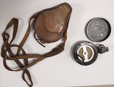
Instrument - Compass and case
Used by John Burke at the State Rivers Tatura in the 1960 - 1970's.Compass: black and silver rimmed round container with removable lid. Bottom section has a clear glass with black rim covering the compass pointer and directions. Has 8 gold screws in black rim. Attached to rim is a hinged section with middle section see through. Opposite hinged section is another hinged section with sight on it. On outside rim of container under second hinged piece, is a black metal ring for holding. Bottom of the container has a flanged circle which attaches to a stand. Case: is tan leather with stitching around all edges. Two pieces, one large which holds the compass and the other is joined to bottom piece to form a lid. A leather strap is joined to the large section to hold the lid down and to make a carrying strap. Inside is red felt.compass, john burke, state rivers tatura -
 Malmsbury Historical Society
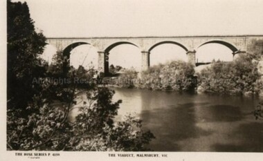
Postcard (Item), "Postcard Of The Viaduct Malmsbury, Rose Series P4159", Malmsbury c1923
Associated with - Rose Series P4159 Buildings - "Viaduct, Coliban River, Gardens" -
 Melbourne Tram Museum
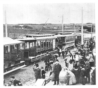
Photograph - NMETL trams at Saltwater River, c1906
The photograph is of a group of two trams and two trailers of The North Melbourne Electric Tramways and Lighting Co. (NMETL) at the Saltwater River terminus for a major event. The river is now the Maribyrnong. Possibly at the time of the opening or soon after as the road surface alongside the trams is unformed, just ballast.Yields information the NMETL trams possibly soon after opening in 1906.Black and white photograph with notes on the rear.In pencil "No 14, 064". tramcars, tramways, v class, u class, trailers, nmetl, saltwater river, maribyrnong river -
 Orbost & District Historical Society
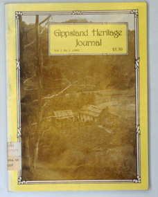
book, E-Gee Printers, 1986
Gippsland Heritage Journal is a journal, produced about every nine - twelve months, for those interested in regional, local and family history in Gippsland, Victoria, Australia. It is compiled by Meredith Fletcher, Debbie Squires and Linda Barraclough and includes a diverse range of articles, both academic and non-academic. Since No.24 it has been a partially refereed journal. Both copies were used at Orbost High School / Orbost Secondary College.This is a useful research tool on the history of Gippsland.Tw copies of a 64 pp magazine, (2322.1 is plastic covered), titled Gippsland Heritage Journal. The front cover is yellow with a b/w photograph of the Culhane house at Crooked River near Grant. The magazine contains photographs, articles on the history of Gippsland. -
 Orbost & District Historical Society
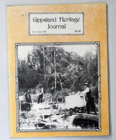
book, E-Gee Printers Pty Ltd, Gippsland Heritage Journal, June 1990
Gippsland Heritage Journal is a journal, produced about every nine - twelve months, for those interested in regional, local and family history in Gippsland, Victoria, Australia. It is compiled by Meredith Fletcher, Debbie Squires and Linda Barraclough and includes a diverse range of articles, both academic and non-academic. Since No.24 it has been a partially refereed journal. This copy was used in the library of Orbost Secondary College. This item is a useful reference tool on the history of Gippsland. A 64 pp magazine, titled Gippsland Heritage Journal No 8 (June 1990). The cost is $6.00. The front cover is pale orange with a b/w photograph of mining on Taraga River, Neerim South. The magazine contains photographs, articles on the history of Gippsland. -
 Kiewa Valley Historical Society
Map - Bogong High Plains - Grazing Runs, Grazing Run Boundaries 1960 - Soil Conservation Authority
Cattle grazing on the Bogong High Plains during summer commenced in the 1840s and continued for many years. The Soil Conservation Authority recorded each family's area boundaries which were updated in June 1972 and continued to be adjusted until cattle were banned in 2005. The tradition of cattle grazing continues to be controversial.Holders of grazing rights for grazing on the Bogong High Plains were allocated specific areas recorded by the Soil Conservation Authority in 1972. Cattle have been banned in the Alpine National Park due to their impact on the environment.White paper with brown print. Bogong High Plains from Feathertop in the west to Mt Nelse in the east showing physical boundaries including the Kiewa Hydro Electric Scheme, roads, rivers and mountains. Names of families with grazing runs and the boundaries are shown.cattlemen, grazing runs, bogong high plains, kiewa valley families -
 Warrnambool and District Historical Society Inc.
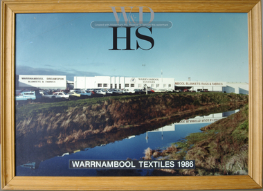
Photograph - Photograph, framed Warrnambool Woollen Mill
In 1869, the Warrnambool Meat Preserving Company commenced their business on the site, where it operated until 1875 when it was sold to the directors of the Warrnambool Woollen Mill Company. After being destroyed by fire in 1882 it wasn’t until 1910 that the Warrnambool Chamber of Commerce was approached by Marcus Saltau and Peter McGennan to invest in a new mill. The original directors were James Dickson, P J McGennan, Robert Swinton, M Saltau, and J W Younger. In 1955 the Warrnambool Woollen Mill formed a partnership with the Wangaratta Woollen Mills. Dunlop bought the mill in 1968. From that time until its closure in 2000 it had a number of different owners, the last being the Smith Family Industries. The Mill site holds significance for Warrnambool as the site was one of the earliest industries established in the town. The Warrnambool Woollen Mill operated for close to 100 years and in that time forged a strong link with the people of Warrnambool. Its product held a significant position in the marketplace.Colour photograph of the Warrnambool Woollen Mill and surrounding area including carparks. The Merri River crosses from lower left to mid right. Aspect is looking easterly. Photo glued to white card mount with text in black underneath. Timber frameWarrnambool Woollen Mill A division of Dunlop Olympic Limited. Manufacturers of Warrnambool/Dreamspun blankets, rugs and fabrics. Registered office South Warrnambool, Victoria. 3280. Australia. P.O. Box 484 Telephone (055)624166. Telex 55820 warrnambool, warrnambool woollen mill, woollen mill, dunlop olympic, marcus saltau, p j mcgennan, james dickson, robert swinton, j w younger, dreamspun -
 Bendigo Historical Society Inc.
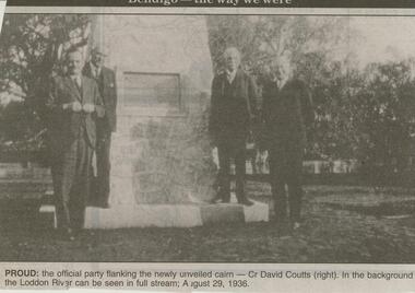
Newspaper - JENNY FOLEY COLLECTION: PROUD
Bendigo Advertiser ''The way we were'' from 2001. Proud: the official party taking the newly unveiled cairn - Cr David Coutts (right). In the background the Loddon River can be seen in full stream; August 29, 1936. The clip is in a folder.newspaper, bendigo advertiser, the way we were -
Bendigo Historical Society Inc.
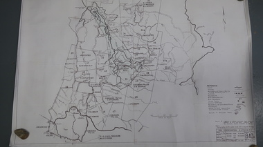
Map - CAMPBELL COLLECTION: BENDIGO AND DISTRICT MAPS
Map. Kimbolton, Parishes of Kimbolton and Lyell, scale 20 chains to 1 inch. Area by Planimeter 6258 acres. Knowsley. 10 1/2 miles to Strathfieldsaye. Campaspe River at bottom right of map. (number 365 in map cupboard 1)map, bendigo, allotments -
 Bendigo Historical Society Inc.
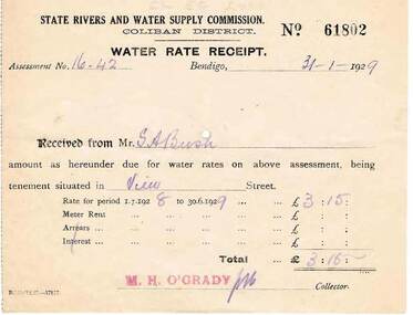
Document - BUSH COLLECTION: RECEIPTS AND NOTICES FOR THE PROVISION OF SERVICES, 1920 - 1930
Collection of approximately 22 receipts and notices pertaining to S. A. Bush. Includes documents from Bendigo Sewerage Authority, State Rivers and Water Supply Commission, Bendigo Gas Company, Plus Dividend Notices from The Colonial Gas Association Limited.person, individual, bush collection - personal -
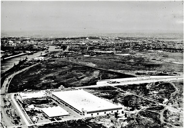 Port Melbourne Historical & Preservation Society
Photograph - Aerial view of Fisherman's Bend circa 1940, circa1940
From the collection of Terry KEENAN. The 9 hole golf course known as the Sandridge Golf Club was part of Victorian Golf Clubs until it moved to Cheltenham in 1927. Trotting 'Speedway' located at top right of photograph.Black and white photograph of Fishermans Bend, Port Melbourne, c. 1940 showing General Motors Holden in the foreground. The original home of the Victoria Golf Club is shown on the left beside the Yarra River winding towards the city & North & South Wharves. built environment, fishermans bend, built environment - industrial, general motors-holden, victoria golf club, sport - golf, sport - horse racing -
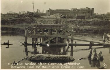 Bendigo Historical Society Inc.
Postcard - ACC LOCK COLLECTION: THE BRIDGE AFTER GERMAN OFFENSIVE BETWEEN BAC ST. MAUR AND CROIX DU BAC, POSTCARD, 1914-1918
Postcard, WW1, B&W image of a ruined wooden bridge over a river between Bac St. Maur and Croix du Bac, after a German offensive. Two piles of timber in front of a damaged building in background. Copy Z 27postcard, postcard, ww1, bac st.maur, croix du bac, france -
 Sunshine and District Historical Society Incorporated
Map (1967), CITY OF SUNSHINE, June 1967, 1967
The City of Sunshine no longer exists. Part of the eastern area has been annexed by the City of Maribyrnong, and the rest of the old City of Sunshine has been amalgamated with the City of Keilor to form the larger City of Brimbank.This 1967 map is a historical record of the City of Sunshine as it existed 27 years before the amalgamation of Councils, and the creation of the City of Brimbank in 1994.Whitish paper map with black printing that is laminated in clear plastic film, and has a wood slat attached to the top edge. The June 1967 map is of the previous CITY OF SUNSHINE showing City and Parish boundaries, streets, railways, creeks, river etc.Purple ink stamps at top left hand and right hand areas showing address and contact details of 'Sunshine Industrial Promotion Centre.'city of sunshine, june 1967, map, city, parish, boundaries, brimbank -
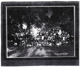 Whitehorse Historical Society Inc.
Photograph, Methodist Sunday School, 3/11/1931 12:00:00 AM
Mitcham Methodist Sunday School Picnic taken 3 November 1931,at what is now Whitefriars College, Donvale. Methodist Sunday School picnic was an annual affair until the mid-1950's to either Seaford beach or the Yarra River at Warrandyte.methodist church mitcham -
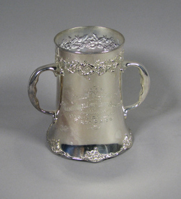 Tennis Australia
Prize cup, 1906
Silver-plated tankard inscribed: '1906/ANNUAL TOURNAMENT/OF THE HUDSON RIVER LAWN TENNIS ASSOCIATION/POUGHKEEPSIE, N.Y./MEN'S DOUBLES/FIRST PRIZE/WON BY'. Stamped on base: 'DERBY SILVER CO/QUADRUPLE PLATE/459'. Materials: Silver/Metaltennis -
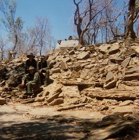 8th/13th Victorian Mounted Rifles Regimental Collection
Photograph
In 1988, as part of a Defence of Mainland Australian policy, defence of facilities of strategic importance in northern Australia were allocated to Army Reserve units. ‘A’ Squadron was allocated the defence of Tindal Air Force base located 15 KM outside Katherine in Northern Territory. Consequently the Squadron deployed on Exercise ‘Northern Explorer’ to gain first-hand knowledge of operating conditions for mounted and dismounted patrolling in the area.Colour photograph of vehicle patrol of ' A " Squadron 8/13 VMR accessing the viability of a crossing point of Ferguson River during Exercise ' Northern Explorer. The patrol decided the Armoured Personnel carrier could descend the shale bank but not climb out again. -
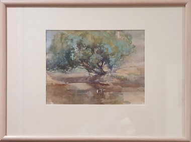 Federation University Art Collection
Painting - Watercolour, McGeorge, Norman, Untitled, c mid 1940s
Norman MacGEORGE (08 July 1872– 2 September 1952) Born Adelaide, South Australia Norman Macgeorge taught drawing at Wesley College, Melbourne from 1902-06. He also taught at Melbourne Teachers' College and at Melbourne Church of England Grammar School. This item is part of the Federation University Art Collection. The Art Collection features over 2000 works and was listed as a 'Ballarat Treasure' in 2007.Framed landscape depicting the confluence of the Darebin Creek and the Yarra River. Purchased by the Ballarat Teachers' College in 1964. This work was exhibited in "Norman MacGeorge: Man of Art" at the Ian Potter Museum of Art, The University of Melbourne, 22 September to 25 November 2001.art, artwork, norman mcgeorge, mcgeorge, watercolour, available, landscape, darebin creek, yarra river, ballarat teachers' college art collection -
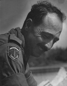 National Vietnam Veterans Museum (NVVM)
Photograph, Gibbons, Denis, AATTV Major
Denis Gibbons (1937 – 2011) Trained with the Australian Army, before travelling to Vietnam in January 1966, Denis stayed with the 1st Australian Task Force in Nui Dat working as a photographer. For almost five years Gibbons toured with nine Australian infantry battalions, posting compelling war images from within many combat zones before being flown out in late November 1970 after sustaining injuries. The images held within the National Vietnam Veterans Museum make up the Gibbons Collection.A black and white photograph of Hue, 1 Corps, South Vietnam 1969. An Australian Army Training Team Vietnam (AATTV) Major looks relaxed as he is paddled up the Perfume River, by members of his unit stationed North West of Hue.photograph, hue, perfume river, 1 corps, aattv, gibbons collection catalogue, denis gibbons, photographer, vietnam war, australian army training team vietnam (aattv), major -
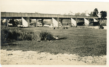 Lakes Entrance Historical Society
Photograph - Bridges, 1925
Black and white photograph showing rail bridge across Mitchell River. Photograph shows side of rail bridge on south side, trees top right hand corner. Left hand side of photograph shows the road bridge. Bairnsdale, Victoriabridges, waterways -
 Bendigo Historical Society Inc.
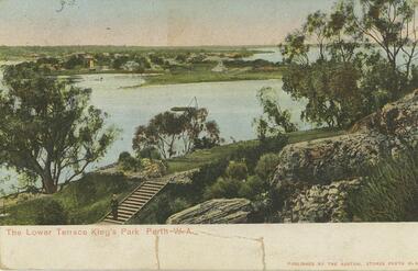
Postcard - Alice McGregor Postcard Collection, 1900 - 1920
Alice McGREGOR Born: 1908; unknown parents. Possibly adopted by the Salter family? Electoral Roll 1936: Highland Terrace Kangaroo Flat. Alice Mary Salter and William Robert Salter living together; presumed to be sister and brother. William Robert Salter was killed in a MVA in Bendigo in 1937 aged 26. In Victoria in 1938, Alice Mary Salter married James Thomas McGregor (born Victoria 1917, died Victoria 1983, buried Fawkner Cemetery) Lived: 1968; 22 Wade Street Golden Square Alice McGregor Died: 1999 aged 91 at Anne Caudle Centre, Bendigo Buried: Kangaroo Flat Cemetery See additional research. Postcard Album of Alice McGregor contained 86 post cards.Postcard Album of Alice McGregor containing 86 post cards. See 1400. Colour photo of The Lower Terrace, King's Park, Perth. W.A. Swan river in middle ground, man standing at bottom of steps. Early years of Perth in background Addressed to Miss A. Stapleton, Arcade, Bendigo, Victoria Sender not given Undated postcard, collector, alice mcgregor -
Lakes Entrance Historical Society
Book, Commonwealth of Australia, Division of Gippsland. Roll of electors for the subdivision of Cunninghame.1905, 1905
Alphabetical list of persons on the electoral roll for Cunninghame, Division of Gippsland in 1905. Gives name, sex, place of living and occupation. Also electoral roll for 1912 also 1985 Orbost Shire rates people living in Reeves River .estimated populdirectories -
 Lakes Entrance Historical Society
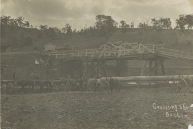
Photograph, John Flynn, Crossing the Buchan, 1906
Bridge was built in 1896 and never finishedBlack and white photograph of bullock team pulling timber jinker with very long logs across the Buchan River beside the footbridge. Several men in charge of team and four girls on the hill, cottage and barn seen, bridge not finished Buchan VictoriaCrossing the Buchantransport, waterways, bridges, people