Showing 22490 items matching " shire"
-
 Otway Districts Historical Society
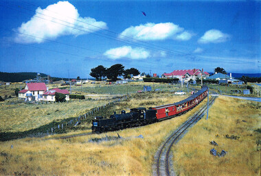
Photograph, Phil A'Vard, Beechy: "Kanyana Special" departing, 1 March 1959
Several "Kanyana Special"s ran from Beech Forest to Colac in the late 1950s to the early 1960s. This photograph of the locomotive G41 and carriages was taken in Beech Forest on 1 March 1959. In the background the Anglicn Church and the Otway Shire Hall and residence are shown.Beech Forest. "Kanyana Special" departing. 1 March 1959. Anglican Church and house, Otway Shire Hall and residence in background. Colour.colac; beech forest; "kanyana special"; anglican church; otway shire hall; locomotive g41; -
 Glenelg Shire Council Cultural Collection
Medal - Medallion - Shire of Heywood, 1863
Copper medallion, Shire of Heywood coat of arms, bordered by 'Shire of Heywood 1863' (modern)medal, medallion, shire of heywood, 1863 -
 Lakes Entrance Historical Society
Photograph - Tambo Shire Councillors, Lakes Post Newspaper, 1990
Black and White Photograph of Shire councillor Bob Crouch Tambo Shire Gippsland Victoriamuincipal history, local government -
 Eltham District Historical Society Inc
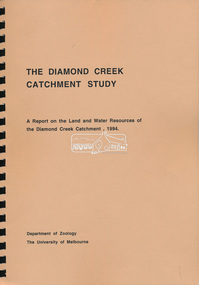
Book, Department of Zoology, The University of Melbourne, The Diamond Creek Catchment Study: A report on the Land and Water Resources of the Diamond Creek Catchment, 1994
Shire of Nillumbik -
 Eltham District Historical Society Inc
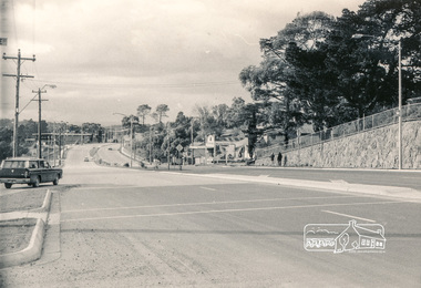
Photograph, Intersection of Main Road and Bridge Street, 1971, 1971
Black and white photograph (2)Shire of Elthambridge street, main road, eltham -
 Eltham District Historical Society Inc
Photograph, Looking down Pryor Street to Main Road, Eltham, c.1960
Eltham Plumbing Supplies (Lennie Whiteway Plumbing) located on the right side of the street. It later became the Eltham Bookshop and sold cane ware as well. On the corner with Main Road is the local branch of the State Bank of Victoria. The building still stands and is the present day Westpac bank branch. The Railway Station Master's house on opposite side was later demolished to make way for a carpark. 27 Aug 1963: Pettion for Bankruptcy re Jeanette Patricia Whiteway of 88 Napoleon Street, Eltham, house duties, and lately carrying on a business at Pryor Street, Eltham in partnership with another as a plumber under the names Eltham Plumbing Supplies and L. & J.P. Whiteway 1963 'SEQUESTRATION ORDERS AND FIRST MEETINGS', Commonwealth of Australia Gazette (National : 1901 - 1973), 12 September, p. 3259. , viewed 10 Jul 2018, http://nla.gov.au/nla.news-article241015035 Orders for discharge of bankruptcy suspended till 23 March 1967 for Leonard Whiteway and Jeanette Patricia Whiteway of 5 John Street, Eltham 1967 'NOTICE OF ORDERS OF DISCHARGE', Commonwealth of Australia Gazette (National : 1901 - 1973), 11 May, p. 2427. , viewed 10 Jul 2018, http://nla.gov.au/nla.news-article241040009Black and white photograph prints (x3) Negative (copy) 4x5 large format Black and White (x2)Shire of Elthampryor street, eltham plumbing supplies, main road, eltham, eltham bookshop, jeanette patricia whiteway, lennie whiteway plumbing, leonard whiteway, state bank of victoria, station masters house, westpac bank -
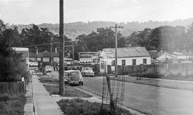
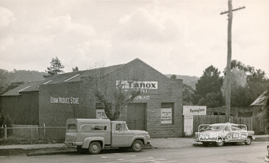 Eltham District Historical Society Inc
Photograph, Eltham Produce Store, c.1960, 1960c
Black and white photographShire of Elthameltham produce store -
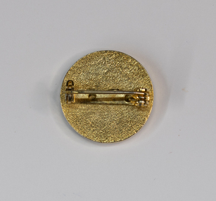 Charlton Golden Grains Museum Inc
Badge - Shire Badge
Gold Toned round badge with logoTHE SHIRE OF CHARLTON -
Bendigo Historical Society Inc.
Map - CAMPBELL COLLECTION: BENDIGO AND DISTRICT MAPS, 21-8-1972
Map. Shire of Strathfieldsaye Locality Plan. Scale 1 inch=1 mile. Drawn by M.Higgs 21-8-1972, Shire of Huntly, Shire of McIvor, City of Bendigo, Shire of Marong, Shire of Maldon, Shire of Metcalfe, Lake Eppalock, Axedale Township, Strathfieldsaye Township, Melbourne to Bendigo Railway Line, Big Hill Tunnel, Mt.Herbert 1596. (number 398 in map cupboard 1)M.Higgs 21-8-1972map, bendigo, locality plan -
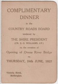 Rutherglen Historical Society
Menu and Toast List, Complimentary Dinner to the Country Roads Board, 1937 (exact)
Dinner was held at the Victoria Hotel, Rutherglen. The Shire President was Cr. S.G. Williams, J.P.Small card folder, with menu and toast list"Complimentary Dinner to the Country Roads Board tendered by the Shire President on the occasion of the opening of the Ovens River Bridge on 24th June, 1937"country roads board, ovens river bridge, opening celebration -
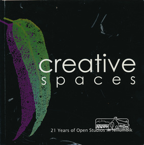 Eltham District Historical Society Inc
Book, Creative Spaces : 21 years of Open Studios in Nillumbik, 2008
Published for the Nillumbik Artists' Open Studio Program. Text edited by Tony Summers and Elizabeth Vercoe. All images by Tony Summers, Upfront Pictures unless otherwise credited. Contents: Nillumbik Artists' Open Studios, Nillumbik: an historic and artistic meander, Open Studio: a reflection, Open Studios: a historic reflection, the artists, the studios, Linda MacAulay, Chris and Mary-Lou Pittard, Linda De Toma, Peter Accadia, Wendy Hicks, Stephanie Mew, Piers Brown, Jane Annois, The Naughty See Monkey, Ona Henderson and Sydd Tunn, Robina and Tony Summers, Peter Oyston, Elizabeth Vercoe, Judy Racz, Veronia Holland, Shaaron Smith, Margaret Summerton, Kim Tarpey, Judy Trembath, Dena Ashbolt, The Bladessin Press, Rob Hayley. The Nillumbik Artists' Studios Program was created in the 1980s by the Shire of Eltham and continues to operate throughout the Shire of Nillumbik in 2018. The program offers the rare opportunity to visit studios and talk to artists about their work in their own working environment.Softcover bound book. Text with colour photographs. Includes profiles of artists from the Shire of Nillumbik. 95 pagesnillumbik artists' open studios, linda macaulay, chris pittard, mary-lou pittard, linda detoma, peter accadia, wendy hicks,, stephanie mew, piers brown, jane annois, the naughty see monkey, ona henderson, syd tunn, ronina summers, tony summers, peter oyston, elizabeth vercoe, judy racz, veronia holland, shaaron smith, margaret summerton, kim tarpey, ev hales, judy trembath, dena ashbolt, baldessin press, rob hayley -
Whitehorse Historical Society Inc.
Document, Lilydale by Marian Aveling, n.d
Copy of a photograph of Melba's return to Lilydale in 1902.Copy of a photograph of Melba's return to Lilydale in 1902 showing her being escorted from a flower-laden rotunda by Shire President Cr A.B. Taylor with David Mitchell following.Copy of a photograph of Melba's return to Lilydale in 1902. mitchell, david, melba, nellie (dame) -
Glenelg Shire Council Cultural Collection
Photograph - Photograph - Councilors at Casterton Town Hall, c. 1963
Sourced from Casterton Town Hall (former Shire of Glenelg)Black and white photo. Three West Riding councilors sitting behind a desk. Honour Board of Past Presidents of Shire of Glenelg, 1863 - 1963, on wall behind them. Council Chambers, Casterton Town Hall.Front: 'D' - pencil Back: 'West Riding Councilors' Blue biro line, arrowed each end, drawn across photo. '3" ' above line -
Glenelg Shire Council Cultural Collection
Clothing - Tie, c. 1996
PArt of the Glenelg Shire Council uniformMen's tie, woven and manufactured in Australia with original Glenelg Shire Logo. Tie is navy blue with red, blue green diagonal stripes and GSC logo embroidered in red and green at the wider point end. In original plastic packaginguniform, civilian, tie, male clothing -
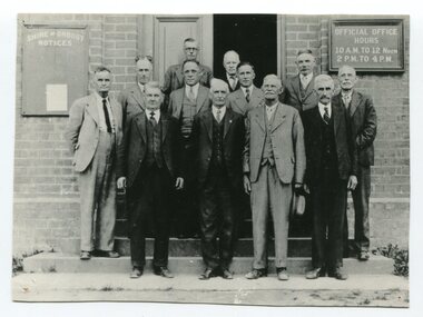 Orbost & District Historical Society
black / white photograph, first half 20th century
This is a photograph of some of the Orbost Shire councillors standing outside their council chambers. This photograph was taken before 1969 outside the previous council offices in Orbost. The current building was opened on Friday 28th February 1969 by the Premier of Victoria, The Hon. Sir Henry E. Bolte, K.C.M.G., M.P. The Shire of Orbost was a local government area about 380 kilometres east of Melbourne, the state capital of Victoria, Australia. The shire covered an area of 9,347 square kilometres and existed from 1892 until 1994. Originally, Orbost was part of the Bairnsdale Road District which was created on 30 April 1867. Splitting away as part of the Shire of Tambo in 1882, Orbost was first incorporated as a shire in its own right as the Shire of Croajingolong on 30 May 1892. It received its present name on 17 February 1893. On 3 January 1913 part of its western riding was annexed to Tambo as its Cunninghame Riding. Local governments play an important role in the lives of citizens in Australia. Local government authorities exist to provide services and amenities to local communities, and are also responsible for regulating and providing services for land and property in their district. This item is representative of a time when Orbost had its own Shire Council. A black / white photograph of a group of men standing in front of an open door of a brick building. On the left of the building is a Shire of Orbost notice board and on the right wall is a notice of the office opening hours - 10AM - 12 NOON 2PM - 4PMorbost-shire-council local government -
Bendigo Historical Society Inc.
Document - Voters' Roll for the Strathfieldsaye Riding of the Shire of Strathfieldsaye, July 1888
Strathfieldsaye Shire Council was located 8km south-east of Bendigo. Its name recalled the Duke of Wellington's Hampshire estate; it was also the name of a migrant ship in 1839 and of William Raymond's station in 1842. Strathfieldsaye became a district in 1861 and a shire in 1866. The shire hall from the nineteenth century still exists.Voters' Roll for the Strathfieldsaye Riding of the Shire of Strathfieldsaye - Four Page Document. Contains 121 names: Surname; Christian Name; Trade ofr occupation; Description and situation of rateable property; Electoral District and Division; number of votes which voter is entitled.history, bendigo, abbott collection, strathfieldsaye, strathfieldsaye riding, shire of strathfieldsaye -
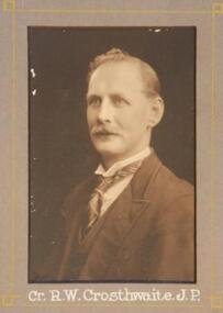 Learmonth and District Historical Society Inc.
Photo - Crosthwaite.R,W, Richards & Co. Photos Ballaarat, Crosthwaite, R.W. Councilor 1934-1935, 1935 (exact)
This photo of Councilor R.W.Crosthwaite,(J.P.) forms part of a composite photo of all Councilors for 1934-1935.He was elected, as a member, to council 1928-47,and was Shire President in 1935-36,1941-42. Original Historic Photo of Councilors for the Year 1934-1935.This Photo Of Councilor R.W.Crosthwaite,(J.P.)on grey mount, is situated left hand side, middle row,of composite photo of all councilors for the year 1934-1935.Collection of photos for the year 1934-1935.shire, council, 1934 1935, crosthwaite, r w j p ballarat -
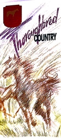 Melton City Libraries
Pamphlet, Thoroughbred Country, c.1985
"Melton has a long and celebrated history of horse breeding and racing. Draught horses were a crucial aspect of life in the early days of European settlement, and were heavily depended upon for both transport and agricultural labour. Peppercorn trees at the corner of Station and Brooklyn roads have been associated with a horse trough installed there to provide a drink to workhorses carting produce to the chaff mills and railway station south of Melton.20 Breeders, trainers and harness drivers in the area later became such an influential force in the equine industry that this came to be a defining aspect of the district’s identity and reputation.Pioneer of the Victorian horse racing industry and early Rockbank squatter William Cross Yuille was one of the earliest importers of stud racehorses in the district in the 1850s. A leading sports editor and writer, Yuille established bloodstock auctioning agency W. C. Yuille & Co. and was involved in the compilation of the first Australian Stud Book, which ensures the integrity of thoroughbred breeding in Australia. According to early Melton chronicler Alexander Cameron, horse races were first organised in the area by Rockbank farmer William Keating. Keating owned racehorses of his own, and many brought horses from Melbourne for the events, which ‘drew large gatherings’.22 Melton Racing Club meetings were held on the Exford Estate with the permission of H. W. Staughton, who built a small wooden grandstand in 1882. Other early races and sports meetings are said to have been held in the vicinity of the current-day Melton golf course.23 An 1884 article reported that Melton’s ‘race programme … equals any put forth by country towns of far greater size’. Ernest Clarke was another important figure in the early horse racing industry in Melton. He established the Melton Stud in 1902, which bred numerous successful racehorses. Perhaps most notably The Welkin, one of the most famous stallions in Australian horse racing in the early twentieth century. The Welkin sired Gloaming, bred by Clarke at the Melton stud in 1915 and one of Australia’s greatest champion racehorses. During a long and prestigious career in both Australia and New Zealand, Gloaming achieved a triumphant 57 wins out of 67 starts and won a record amount of prize money. Ken Cox purchased the Stockwell Stud in Diggers Rest in 1957 and developed it into one of the largest and most renowned thoroughbred breeders in Australia. With its top-class facilities, international design standards and scientific methods, Stockwell became ‘the flagship of the Victorian breeding industry’.26 As well as racing studs, numerous trotting tracks were established on the flat plains around Melton in the 1960s.27 Other studs to play a leading role in the development of Melton as thoroughbred country were Cornwall Park and Merrywood at Toolern Vale, St John’s Lane Stud at Diggers Rest and Birchwood, Teppo Park and Dreelburn in the far north-east of the shire, near Sunbury. By 1985, thoroughbred horse breeding was such big business in Melton that the shire council adopted the slogan ‘The Heart of Thoroughbred Country’, which was used throughout its promotional material.29 But the slogan contained deeper meaning and was not just about Melton’s great equine industry and thoroughbred champions, the council explained: ‘“Thoroughbred Country” should be seen as a new concept of Melton, as a place where people can achieve the “Thoroughbred” ideal, excellence in all aspects of life’. The aim of the council in promoting ‘The Heart of Thoroughbred Country’, was ‘to instil in present and future residents the feeling that this is a place that is better than others. A place to be proud of’. In 1988, Melton’s champion reinsman Gavin Lang won his 176th race of the season, claiming the national harness racing record for the most wins in a single season.The following year, the first Melton Plate was held at Moonee Valley Racecourse, cementing the district’s importance in the harness racing industry. The inaugural winner was Victorys Phil, owned by local Danny Mullan. By the 1990s, Melton had earned the title of the ‘Home of Harness Racing in Victoria’. State-of-the-art, world-class harness racing facility and entertainment complex Tabcorp Park opened in Melton in 2009. In 2011, the Shire of Melton was home to over 140 registered trainers and over 1,200 horses. The municipality’s continuing leadership and influence in the industry today is a testament to the skills, talents and leadership of the local community over its history".Shire of Melton pamphlet of a map and information of the equine industry in Meltoncouncil -
 Port Fairy Historical Society Museum and Archives
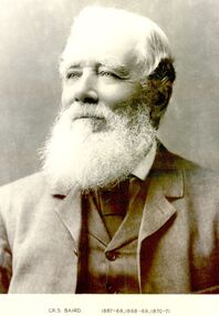
Photograph, Cr S Baird 1867-68,1868-69,1870-71
Councillor Samuel Baird’s residence was the property known as ‘Warrong Station” north of Kirkstall. During the last year of his presidency he played an important part in obtaining the severance of the Shire of Minhamite from the Belfast Shire. Councillor Baird was the first president of the Minhamite Shire.Black and white portrait president, portrait, government, shire, municipal, local-government, minhamite shire, shire of belfast -
 Warrnambool and District Historical Society Inc.
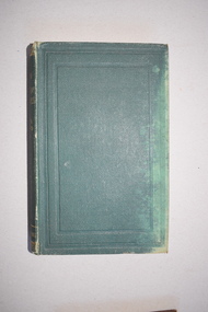
Book, The Theory and Design of Structures, 1921
This book belonged to Rolf Crawley who was an engineer in the employ of the Shire of Warrnambool at the time he acquired this book. In 1926 he was the engineer/secretary for the Minhamite Shire, returning in 1935 to the Shire of Warrnambool as the engineer after the death of his father, John William Crawley Junior. Rolf retained this position until 1968. Rolf’s grandfather, father and uncle had all been engineers or shire secretary for the Shire of Warrnambool, with the Crawley family recording a total of 132 years of service to the Shire of Warrnambool which existed from 1863 to 1994. This book is retained as a memento of Rolf Crawley, the engineer with the Shire of Warrnambool from 1935 to 1968. This is a hard cover book of 626 pages. The cover is green with gold lettering on the spine. The edges of the cover are rubbed. The book contains a preface, 18 chapters of text and an appendix. The pages contain many diagrams and plans. The inscriptions on the first page are handwritten in black ink. There is a label from the bookseller attached to the first page. Rolf L. Crawley 1922 Please return to R.L.Crawley ‘Korongah’ Port Fairy or Shire Hall Warrnambool Tait Book Co. 90 William Street St. Melbourne for Technical Books crawley family, warrnambool, shire of warrnambool, history of warrnambool -
Clunes Museum
Document - REPORT, WENDY JACOBS, QUEENS PARK CLUNES, JUNE 1994
CONSERVATION AND ANALYSIS POLICY. ORIGINALLY PREPARED BY RICHARD AITKEN, REVISED AND REPRINTED BY WENDY JACOBS, HERITAGE ADVISER , SHIRE OF TALBOT AND CLUNES. JUNE 1994.REVISED AND REPRINTED FROM THE CONSERVATION ANALYSIS AND CONSERVATION POLICIES ORIGINALLY PREPAREDT BY RICHARD AITKEN 15 FEBRUARY 1990CONSERVATION ANALYSIS AND POLICIES OF QUEEN'S PARK, CLUNES. 54 PAGE, UNBOUND REPORT.- PHOTOCOPIED. REVISED AND REPRINTED BY WENDY JACOBS, HERITAGE ADVISER, SHIRE OF TALBOT AND CLUNES JUNE 1994report, queens park, cameron street -
 Whitehorse Historical Society Inc.
Article, Parting of the ways, n.d. (original 1925)
Retiring councillors entertained by Shire President following the establishment of the Shire of Blackburn and Mitcham in 1925. Speeches made by many councillors in response to president's proposal of toast to the new shire.local government, young cr, shire of nunawading, shire of blackburn and mitcham, armstrong cr, boyland cr, ellingworth john richard, blood cr, fankhauser cr, husband cr, bayley cr, hurter cr, halliday cr, stevens cr, gawler cr, baker cr, hall cr, horkings cr -
Glenelg Shire Council Cultural Collection
Document - Envelope - Shire of Portland, n.d
Plain white envelope, 'Shire of Portland' top centre, 'Shire Office Heywood', bottom leftshire of portland, administration -
 Hume City Civic Collection
Photograph, 1/11/1974
This building was demolished in 1975 when the extension to the existing Shire Offices were completed later in 1975.Prior to the Sunbury Waterworks Rust occupying this building, a hotel was built on this site in the 1870s and was known as Brown's Hotel. At some stage John McMahon's grandfather owned the hotel.A black and white photograph of a weatherboard house with a tin roof, verandah and paling fence was the home of the Sewerage Authority and Waterworks Trust at the front of the Shire Offices.sunbury sewerage authority, sunbury waterworks trust, shire of bulla, mcmahon, john, burgess, geyer, ronald, sewerage establishments, george evans collection, brown's hotel, john mcmahon -
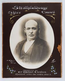 City of Greater Bendigo - Civic Collection
Photograph - Portrait of Councillor Michael Condon, W H Robinson
The district of Strathfieldsaye was proclaimed in 1861 and named a Shire on the 17th September in 1866. It remained a shire until amalgamation in 1994 when it became part of the City of Greater Bendigo. The shire was located 8 km to the south- east of Bendigo and covered an area of 601 square kilometres and extended from the Calder Highway to the Coliban and Campaspe Rivers. The shire's administration centre was in Strathfieldsaye until 1972 when new offices were opened in KenningtonFramed black and white head and shoulder portrait of Councillor Condon with hand coloured and drawn detail. Profile slightly to left. No facial hair. Cut oval brown mount decorated with text, scrolls and flowers. Hand written title top and lower centre.Strathfieldsaye / Shire / Council / W. H. Robinson / Photo / Bendigo / JMB Gribble / Presented by / Cr Michael Condon / President 1889 - 90. 1895-6. 1904 - 5strathfieldsaye shire council, president of strathfieldsaye shire, councillor condon -
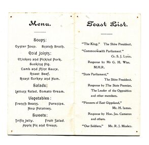 Orbost & District Historical Society
menu, 1916
This event was held on 12th January, 1916 and was held at the Mechanics' Hall. F.A. Nixon was the Shire President. The toast list included toasts to the king, the commonwealth and state parliaments as well as to the pioneers and old soldiers of East Gippsland.This item reflects an event held in Orbost in the early 20th century.A small white menu with black print. On the front are the details of the event, a state parliamentary party dinner with the Orbost Shire emblem at the top. On the back is the menu and the toast list.menu shire-orbost parliamentary-dinner -
Whitehorse Historical Society Inc.
Map, Sample Plan
Sample Plan of Shireroad construction and maintenance -
Glenelg Shire Council Cultural Collection
Photograph - Photograph - Meeting of Viscount de Lisle, Governor General of Australia and Cr. H. D. Mitchell, Shire President, 25/10/1963
Sourced from Casterton Town Hall (former Shire of Glenelg)Coloured photograph of Viscount de Lisle, Governor General of Australia, being greeted by Cr. H. D. Mitchell, Shire President, at Casterton Town Boundary, on 25th Oct. 1963. The photograph is in a cream folder, with green manufacturer's information -
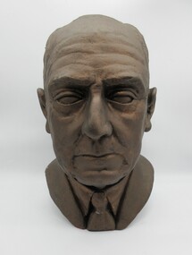 Hume City Civic Collection
Sculpture - Bust, mid 1940's
Sculpture was made by a personal friend of the subject in the mid 1940's and displayed in the home of the subject's son, John B. Crosbie until 2001. Bernard Crosbie (subject) was the nephew of Michael Loeman, former Shire of Bulla President and owner of 'Glen Loeman'. Bernard Crosbie and his brother inherited Glen Loeman from Michael Loeman.Bust of a man, Bernard Michael Crosbie, President of Bulla Shire 1936-1937. Made from plaster of Paris (?) painted metallic brown.crosbie, bernard michael, shire presidents, shire of bulla, loeman, michael, glen loeman, houses, george evans collection -
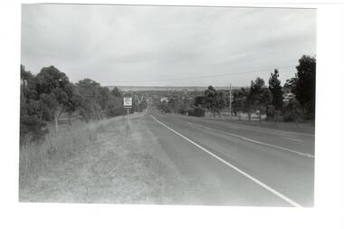 Buninyong & District Historical Society
Photograph - B/W photograph, Mr. Clive J. Brooks, Eastern approach to Buninyong Midland Highway 1994, April 1994
Approach to township of Buninyong prior to amalgamation with Ballarat City Council. Buninyong shire town sign visible in foreground.Record of Buninyong Shire prior to amalgamationBlack and white photograph of the Eastern approach to Buninyong from the Midland Highway taken from opposite Ballantrae looking West. In left foreground is an example of Buninyong shire town sign before amalgamation 1994.buninyong shire, midland highway, street scene