Showing 3605 items
matching street map
-
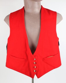 Ringwood RSL Sub-Branch
Uniform, Mess Dress, Evers and Cohen, All three items dated 1963
00134.1 Red Waistcoat with Gold Buttons QE2 crown and map of Australia, 00134.1 Dark Blue Cumbarbun with plastic fittings. 00134.3 Dark Blue Trousers with a single red stripe down the legs -
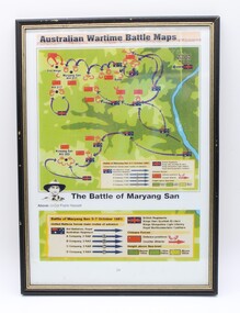 Ringwood RSL Sub-Branch
Map
australian wartime battle maps rectangular frame, the battle of maryang san, -
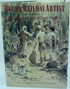 Ringwood RSL Sub-Branch
Book, Burma Railway Artist, 1994
Hard cover with many copies of hand written drawings, maps etc.132 pages, The war drawings of Jack ChalkerFirst published in 1994 in GB by Pen and Sword Books -
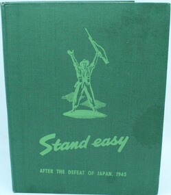 Ringwood RSL Sub-Branch
Book, Stand Easy, 1945
Hard cover with 205 pages containing hand written prints etc with list of contributors. Contains maps supplements.After the defeat of Japan 1945. Published by Australian War Memorial Canberra ACT 1945. -
 Ringwood RSL Sub-Branch
Souvenir card holder
Gold coloured metal case with map of Australia on outside -
 Ringwood RSL Sub-Branch
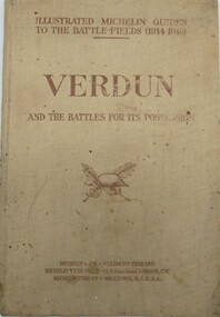
Book, Verdun and the Battles for its Possession, 1919
... Ringwood RSL Sub-Branch 16 Station Street Ringwood ...Maps and details of battles for VerdunSoft cover 116 pagesIllustrated Michelin guide -
 Unions Ballarat
In step with Sturt (Don Woodward Collection), Swan, Keith et al, 1979
The book, targeted at school students, covers the years of Sturt's three expeditions. The authors question Sturt's capability as a surveyor and his leadership.Australian history.Graphic book; 115 pages. Dustjacket: plastic covering; brown and white background; black and white map of Sturt's journey along Murrumbidgee and the Murray River; black, gold and white lettering; authors' names and title. Cover: white and black lettering; authors' names and title.btlc, ballarat trades and labour council, ballarat trades hall, sturt, charles, history - australia, australia - explorers -
Unions Ballarat
Camp Street, Ballarat from Eureka to Federation : a guide to its history and buildings, 2001
A guide to the history of Camp Street Ballarat and its historical buildings. Camp Street has been the location of Unions Ballarat since 1887 - a chapter of the book is dedicated to Trades Hall - and was the home of the former labour newspaper, the Evening Echo. Camp Street was the site of the government camp at the time of the Eureka Stockade. Camp Street is now recognised as an Arts and Education precinct within the city of Ballarat. Headings: Gold fever The CAMPSTREET Project Titanic Bandstand Old Ballarat Free Library Complex "Point to the sky" "Perseus" Former government offices and court house Old Ballarat Court House Alfred Deakin Place Old Police Station (Ballarat Fine Art Gallery) Ballarat Fine Art Gallery Millennium Extension Bluestone Warehouse (Pratt's Warehouse) Old YMCA building Wilson House Ballarat Office Systems Ballarat Trades Hall The ANA Building Freemason's Hall Former Ballarat Trustees and Executors Agency Co. Ltd. Restaurant Former Evening Echo Building Ballarat Savings Bank (now The Ballarat Business Centre) Significant to the history of architecture and social life within the city of Ballarat. Direct relevance to Unions Ballarat building.Book; 48 pages. Cover: blue background; colour photos and maps pertinent to Ballarat; white lettering; title and compiler's name. btlc, ballarat trades hall, ballarat trades and labour council, evening echo, ballarat savings bank, ballarat business centre, freemason's hall - ballarat, ana building - ballarat, ballarat - camp street, wilson house - ballarat, ballarat office systems, ymca building, pratt's warehouse - ballarat, ballarat fine art gallery, old police station - ballarat, alfred deakin place, old courthouse - ballarat, perseus, point to the sky, old ballarat free library complex, titanic bandstand, campstreet project, gold mining - ballarat, architecture - history - ballarat -
Unions Ballarat
Women and children first : an outline of a population policy for Australia, Wallace, Victor Hugo, 1946
Written in 1946, the author presents ways to encourage population increase in Australia. Relevant to social choices and customs in the 1940s.Paper; book. Front cover: red and white with a map of Australia.Front cover: author and title.btlc, ballarat trades hall, ballarat trades and labour council, birth control, population, social policy, social customs, contraception -
Unions Ballarat
Keeping archives, 1987
Guide to archiving practice.Professional practice book.Paperback book. Front cover: grey background; images of a computer, a film and a map of Australia; red and blue lettering.Front cover: Title, organisation and name of editor in chief. Back cover: blurb, title and organisation.archives; archives practice; library, ballarat trades hall, ballarat trades and labour council, btlc -
Unions Ballarat
The ALP : a short history of the Australian Labor Party, McKinlay, Brian, 1981
A concise history of the ALP.Relevant to the history of the ALP and politics.Paper; book. Front cover: orange background with black outlined maps of Australia; black and white photos of various ALP leaders; black lettering.Front cover: title and author's name.btlc, ballarat trades and labour council, ballarat trades hall, alp, australian labor party, history, politics -
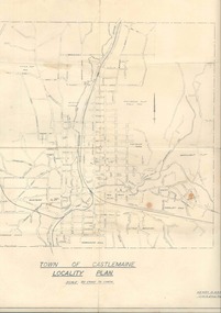 Old Castlemaine Schoolboys Association Inc.
Map, Locality of Castlemaine
-
 Ballarat Heritage Services
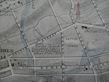
Photograph - Digital photograph, Map Detail Showing the Eureka Stockade site, 1861
... in the affray. eureka site map george street cattle yards eureka street ...Eureka Stockade is the site of the battle between government forces and miners and occurred on 3 December 1854 early one Sunday morning. Around 30 were killed, 130 arrested and 13 tried for High Treason. Many were injured in the affray. digital photographEureka Stockade Engagement between the troops and Ballarat Miners 4th December 1854. * Please note the date is recorded wrongly on the map.eureka site, map, george street, cattle yards, eureka street, ballarat, eureka stockade -
 Hume City Civic Collection
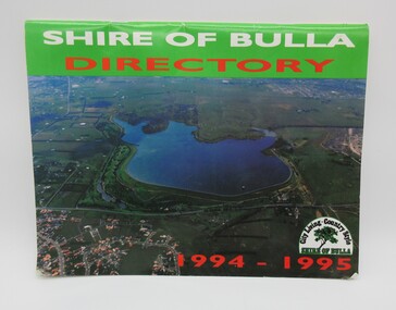
Directory, Shire of Bulla Directory, 1994 - 1995
The Directory was published by the former Shire of Bulla in 1994 - 1995 and was issued to residentsa living withing the Shire. It features details of public services which were available within the area at the time as well as maps of the settlements and some private advewrtisements.A 20 page booklet with an aerial photograph of the Greenvale Dam and surrounding area on the front cover. A green strip is along the spine of the booklet with the words 'Shire of Bulla' printed in white and 'Directory' printed in red. '1994 - 1995' is printed in red across the bottom of the front cover and the Shire of Bulla - 'City Living . Country Style' logo is in the bottom RH corner. The back cover features an advertisement for the Roxburgh housing development.shire of bulla, directory, sunbury, bulla, attwood hill, craigieburn, george evans collection -
Hume City Civic Collection
Booklet - Melbourne Airport
A paperback booklet with a cardboard cover with folding flap on the inside of the front and backnon-fictionmelbourne airport, aviation, airports, tullamarine -
Hume City Civic Collection
Book - Street Directory, Gregory"s Melbourne Street Directory
... and family. Joan Houston Maps Street Directory Roads Suburbs Gold ...This 1972 Gregory's Melbourne Street Directory published by Gregory's Guides & Maps Pty Ltd was used by the donor, her husband and family.A black leather removable cover with gold embossed vintage car on the front enclosing a Gregory's Melbourne Street Directory.Gold embossed vintage car on front cover.joan houston, maps, street directory, roads, suburbs -
Hume City Civic Collection
Print - Street Directory, Gregory"s Melbourne Street Directory, c1972
... & Maps Pty Ltd of 142 Clarence Street, Sydney NSW in c1972 ...This street directory was published by Gregory's Guides & Maps Pty Ltd of 142 Clarence Street, Sydney NSW in c1972. It was used by the donor's family for many years to navigate their way around Melbourne and the metropolitan area. A street directory enclosed in a black leather detachable cover with gold embossing of a car on the front cover.Gold embossed vintage car on front of detachable cover.joan houston, streets, roads, maps, street directory -
Hume City Civic Collection
Map, Sunbury Township 1857
This is a reprint of a 1857 map of the township of Sunbury in the County of Bourke produced by the Public Records Office by courtesy of the Surveyor General in 1978.This is a reprint of a 1857 map of the township of Sunbury.sunbury, shire of bulla, sunbury township, 1850s -
Hume City Civic Collection
Photograph, Rupertswood Gardens
The gardens in the photograph are in the grounds at Rupertswood, the former summer residence of Sir William John and Lady Janet Clarke. Originally the gardens covered 99 acres and included a man-made lake in the shape of a map of Australia.A non-digital black and white photograph with a cream border of the lake and gardens in a spacious area with smaller buildings in the distanc.gardens, william sangster, sir william john clarke, lady janet clarke, trees, salesian college -
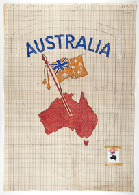 RMIT Design Archives
Mixed media - Drawings, Design for clothing label featuring map of Australia
Cash's first began manufacturing name tags, woven badges and woven labels in Australia in 1913, and since then countless Cash's labels have been sewn onto school and club jumpers. Point paper design featuring map and flag. Corresponding clothing label attachedtextile design, rmit design archives -
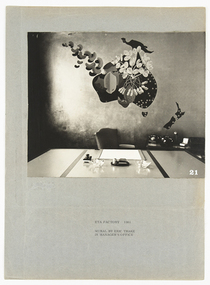 RMIT Design Archives
Photographs, ETA Factory 1961 mural by Eric Thake in manager's office
Eric Thake had a unique way of looking at the world, uniting a singular vision that found the extraordinary in the everyday, with a whimsical sense of humour and refined modernist aesthetic. One of his lesser-known commissions was a mural for the Victorian Manager’s office at the ETA Factory in Braybrook designed by Frederick Romberg in 1957. Photographed here by Kenneth Ross, the mural depicted a stylised map of Australia, with Indonesia above and New Zealand to the south, and showed the peanuts and other raw materials that ETA used in the production of various foodstuffs against a striking and entirely gilded wall. Kirsty Grant, 2017 Black and white photograph of a mural by Eric Thake in the manager's office at the ETA Factory, Melbourne.Typed lower center, 'ETA FACTORY 1961/ MURAL BY ERIC THAKE/ IN MANAGER'S OFFICE'eta, mural, braybrook, manufacturing, architecture, artist -
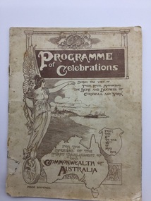 Parliament of Victoria
Programme, Official programme of functions and displays to celebrates the opening of the first Parliament of the Commonwealth of Australia by His Royal Highness the Duke of Cornwall and York, at Melbourne, 1901
Programme of celebrations during the visit of their Royal Highnesses the Duke and Duchess of Cornwall and York for the opening of the first Parliament of the Commonwealth of Australia from the 6th to the 16th May 190148 pages : illustrations, maps, portraits -
Tatura Irrigation & Wartime Camps Museum
Poster, Subdivision of Township Allotments
Poster depicting the land which was being sold by J S Darby on the 3 December 1890. Auctioneer was Martin Cussen and Co. Map shows location of land.Single sheet of paper, laminated. Advertising land subdivision for sale in the township of Rushworth. Being sold by Martin Cussen and Co, auctioneers for J S Darby. Shows map of land subdivision.rushworth, land subdivision, martin cussen and co, j s darby -
Tatura Irrigation & Wartime Camps Museum
Document - Book, H M Rehabilitation Centre Dhurringile: A Conservation Analysis, 1995
A comprehensive book on the life of Dhurringile Mansion from 1800's to late 1900's. Includes maps showing the layout of the Mansion.Printed pages held together with a multiring binder of black plastic. Front cover is clear, back cover is black. Title and black and white photograph of Dhurringile in a square on front.dhurringile mansion, h m rehabilitation centre, winter irving family -
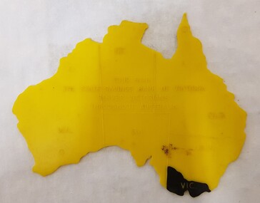 Numurkah & District Historical Society
Equipment - Plastic stencil map/shape of Austalia
Yellow plastic stencil in the shape of Australia, states marked on the map, Victoria painted in blackState Savings Bank of Victoraeducation, school, geography, australia, stencil, drawing -
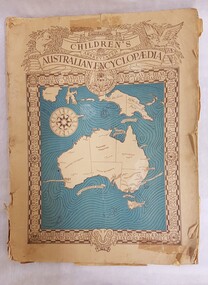 Numurkah & District Historical Society
Book - Children's Encyclopedia, The Sanitarium Children's Abbreviated Australian Encyclopedia (1947)
Paper-covered book with map of Australia on the front coversee photoeducation, school, encyclopedia, general knowlege -
 Brimbank City Council
Manilla Folder
Manilla folder with a number of various sizes envelopes containing black and white phots form around mid 20th century of councillors, residents, street. Aslo number of urban plans and maps. -
Tramways/East Melbourne RSL Sub Branch - RSL Victoria Listing id: 27511
Book, THE WAR OFFICE et al, MANUAL OF MAP READING (AIR PHOTO READING AND FIELD SKETCHING Part1 MAP READING 1955), 1955
-
Tramways/East Melbourne RSL Sub Branch - RSL Victoria Listing id: 27511
Book, THE WAR OFFICE et al, MANUAL OF MAP READING (AIR PHOTO READING AND FIELD SKETCHING PART 11 1958), 1957
-
Tramways/East Melbourne RSL Sub Branch - RSL Victoria Listing id: 27511
Book, THE WAR OFFICE et al, MANUAL OF MAP READING part 111(AIR PHOTO READING AND FIELD SKETCHING PART111 FIELD SKETCHING 1957), 1958