Showing 4312 items
matching ? waller
-
 Bendigo Historical Society Inc.
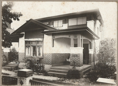
Photograph - T C WATTS & SON COLLECTION: 62 CARPENTER STREET, BENDIGO, 1930
Black and white photographs (s) mounted on rectangular brown board. House, two storey, brick, roughcast above dado height, upper storey has shingles under windows shingles below front gable. Brick verandah piers with wooden freized upperparts. Two stepped masonry approaches, two event verandahs. Roughcast to lower walls below floor level, lower window with six lights [5 leadlighted] On back of photo ' Phillips, Carpenter Street. £2500 sewered with all furnishing including wireless set but not including sewing machine, piano or organ and £3000 with all furniture'. 2012 photo of house attached to record.bendigo, business, t c watts & son -
 Bendigo Historical Society Inc.
Photograph - Kangaroo Flat Gold Mine Collection: underground in Swan Decline, Kangaroo Flat Gold Mine, 2000
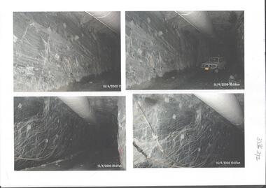
The modern mine is accessed via the Swan Decline, which commences at the Kangaroo Flat site on the southern outskirts of Bendigo and progresses in a north easterly direction between the Deborah and Sheepshead anticlines, reaching a depth of almost 1000 m below the City of Bendigo. Development of this decline commenced in 1998. Swan Decline closed and history preserved In a major rehabilitation milestone at Kangaroo Flat, the Swan Decline Bendigo’s primary gateway to underground mining, was permanently closed in December 2022. Important parts of Bendigo’s gold rush history were also preserved from the onsite office buildings with 19 boxes of records, and 1350 old photos being scanned and provided to the local historical societies and the Goldfields Library Corporation. A volunteer from the Bendigo Historical Society, Kay MacGregor, also scanned approximately 40 bookshelves of newspaper clippings to assist with recording and preserving geological drilling locations.Black and white photocopies of photographs of Swan Decline, showing some stages of underground construction. Eleven images on 3 pages, dated 16/4/2000 (10 a.m.) show decline walls, rock bolts and markout of tunnel shape. One image shows a utility in the tunnel. Final three images on one page, have notations on the photos: 'opposite SP18 LHS decline', 'just up from previous 3 box positions' and 'just up from tank, same side' On bottom RH side 'spots for scale attention, IT required, all lower decline.' All three images dated 12/6/2000.goldmining, kangaroo flat gold mine, western mining corporation, unity mining, swan decline -
 Bendigo Military Museum
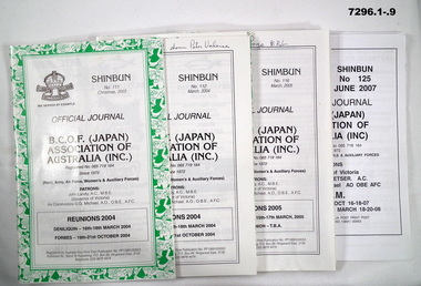
Booklet - BOOKLET -BCOF, B.C.O.F. (Japan) ASSOCIATION OF AUSTRALIA (INC), 'SHINBURN' 'SHIMBUN'
Booklets are the; "OFFICIAL JOURNAL/ BCOF (JAPAN) ASSOCIATION OF/ AUSTRALIA (INC) Since 1972/ (Navy, Army, Air Force, Women's & Auxilliary Forces)" Please note - "SHINBUN - SHIMBUN" - name change on some booklets. Shinbun and Shimbun - is the correct spelling of the word for newspaper in Japanese. Booklets - Items in the collection of Richard William McGILVERY, RAAF. Refer Cat No. 7287P for his service details, photo, awards.SOFT COVER BOOKLET. ALL BOOKLETS - PAPER WITH BLACK PRINT ON FRONT AND BACK. CHRISTMAS ISSUES HAVE DECORATIVE TRIM IN GREEN AND/OR RED PRINT. ILLUSTRATED WITH " BRITISH COMMONWEALTH FORCES" WITH CROWN ON FRONT COVER. All booklets 32 to 50 pages, cut, plain, white paper. Illustrated with black and white photographs, maps and cartoons. 1. No. 111 Christmas 2003. 2. No. 112 March 2004. 3. No. 113 Winter 2004. 4. No, 115 Christmas 2004. 5. No. 116 March 2005. 6. No. 117 June 2005. 7. No. 118 September/Spring 2005. 8. No. 125 June 2007. 9. No. 126 Sept 2007'. 10. No. 129 June 2008. 11. No. 130 September 2008. 12. No. 131 No. December 2008. 13. No. 132 March 2009. 14. No. 133 June 2009. 15. No. 134 September 2009. 16. No. 135 December 2009. 17. No. 136 March 2010. 18. No. 137 June 2010. 19. No. 138 September 2010. 20. No. Front cover - Handwritten notes in black ink. 2/3/4/5/14/15/19/20. 2. "BCOF Memorial shown Peter Valence". 3. "Ron H ??.d Bede Wall writes about". 4. "BCOF Memorial shown to Peter Valence/ S.C.A.P. means/ Supreme Commander of Allied Powers" 5. "Fraternisation Page to Rob". 6. "The Atom Bomb Poem". 14. "BCOF Memorial to show Peter Valence". 15. "Peter Fraser story given to Rob". 19. "19 mags in this lot". 20. 5 mags full of reference/ most of this book". history, booklets, bcof -
 Eltham District Historical Society Inc
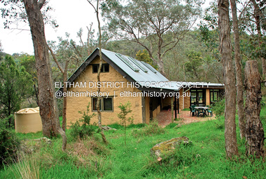
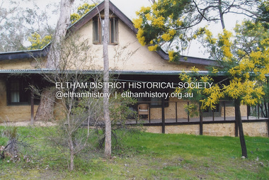
Photograph - Digital Photograph, Jim Connor, Birrarung House, 195 Laughing Waters Road, Eltham, 7 September 2013
Laughing Waters Walk, 7 Sep 2013 This Society excursion was a follow up to the Laughing Waters Story told to us by Jane Woollard at our Annual General Meeting in March 2013. It involved a walk commencing from the corner of Laughing Waters and Overbank Roads along Laughing Waters Road to its eastern end and returning partly over the same route - a total distance of about 2.5km. On the way we visited the two artist in residence properties, River Bend and Birrarung, to view the houses on them that are associated with Alistair Knox, Gordon Ford and others in the local mud brick and artistic community. We also able to walk around the derelict ruin which was once home to Gordon and Sue Ford, Boomerang House. An unexpected afternoon tea was offered to us by the artists in residence at Birrarung House and we had a brief opportunity to view inside the house. Birrarung is situated near the end of Laughing Waters Road. It was built in 1974 by Graeme Rose for Gordon Ford who he had asked to build him a small ‘bach’. Builder Peter Jarvis who did his apprenticeship with Alistair Knox for a couple of years recalled there were no drawings. It evolved as more funds became available. Graeme would source second-hand building materials around which he would shape the house. The fireplace was built with chicken wire over which it was rendered with faro cement. A brick floored glass studio, added later, faces a wall of boulders pressed into a manmade cliff, a large pond the link between the rock wall and glass studio. A waterfall, fed by river water, no longer functions. The property became part of the Laughing Waters Artist in Residency Program with the first artist taking up residency in 2001. For a more in-depth description of the property and biographies of the various artists in residence commencing from 2001 through to 2015, see Jane Woollard's book, "Laughing Waters Road; Art, Landscape & Memory in Eltham" published 2016.2013-09-07, activities, artists in residence, eltham district historical society, heritage excursion, jim connor collection, laughing waters road, birrarung house -
 Eltham District Historical Society Inc
Photograph, Fay Bridge, Birrarung House, 195 Laughing Waters Road, Eltham, 7 September 2013
Laughing Waters Walk, 7 Sep 2013 This Society excursion was a follow up to the Laughing Waters Story told to us by Jane Woollard at our Annual General Meeting in March 2013. It involved a walk commencing from the corner of Laughing Waters and Overbank Roads along Laughing Waters Road to its eastern end and returning partly over the same route - a total distance of about 2.5km. On the way we visited the two artist in residence properties, River Bend and Birrarung, to view the houses on them that are associated with Alistair Knox, Gordon Ford and others in the local mud brick and artistic community. We also able to walk around the derelict ruin which was once home to Gordon and Sue Ford, Boomerang House. An unexpected afternoon tea was offered to us by the artists in residence at Birrarung House and we had a brief opportunity to view inside the house. Birrarung is situated near the end of Laughing Waters Road. It was built in 1974 by Graeme Rose for Gordon Ford who he had asked to build him a small ‘bach’. Builder Peter Jarvis who did his apprenticeship with Alistair Knox for a couple of years recalled there were no drawings. It evolved as more funds became available. Graeme would source second-hand building materials around which he would shape the house. The fireplace was built with chicken wire over which it was rendered with faro cement. A brick floored glass studio, added later, faces a wall of boulders pressed into a manmade cliff, a large pond the link between the rock wall and glass studio. A waterfall, fed by river water, no longer functions. The property became part of the Laughing Waters Artist in Residency Program with the first artist taking up residency in 2001. For a more in-depth description of the property and biographies of the various artists in residence commencing from 2001 through to 2015, see Jane Woollard's book, "Laughing Waters Road; Art, Landscape & Memory in Eltham" published 2016.2013-09-07, activities, artists in residence, eltham district historical society, heritage excursion, laughing waters road, birrarung house, fay bridge collection -
 Flagstaff Hill Maritime Museum and Village
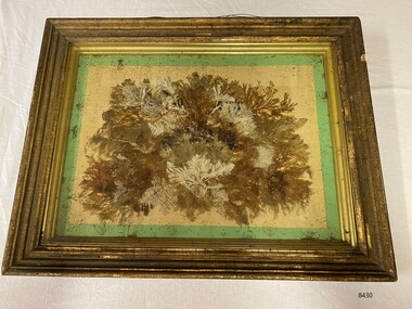
Artwork, other - Diorama with seaweed specimens, Richard Foster Norton, 1860
The diorama of mounted specimens of seaweed was framed by Richard Foster Norton for Thomas Watson and is dated 1860. Watson was the Warrnambool District Surveyor at the time (1860). The inscription on the back of the frame links the artwork to the Pigeon Hill property, which was located on Allansford Road (corner of Staffords Road – north side of the Princes Highway-A1). In the 1860s, the property known as Pigeon Hill was owned by William Wall who was a publican who ran several hotels in Warrnambool and district. In 1860 Wall, was running a hotel in Wangoom, near Pigeon Hill. Further research is required to determine the exact location, but Pigeon Hill could also have been the name for that area and may have had other people living there. Thomas Watson was a member of the local horticultural society. Another possible creator of the artwork is Samuel Hannaford, a biologist with a particular interest in collecting marine flora. Hannaford left Warrnambool in 1857 and went to Geelong, so it is possible he collected the specimens had them framed in Geelong, and then arranged for their return to Watson. The other known seaweed collector was Henry Watts, who lived in Warrnambool in the mid-19th century. The seaweed collection in this box was possibly one of Watts' and could have been prepared for the Victorian Exhibition of 1861, Richard Foster Norton, also known as R.F Norton, was one of only a handful of picture framers in 1850s Melbourne. Norton was born on the 24th of July 1822 in Yelvertoft, Northamptonshire and prior to his arrival in Australia, Norton is listed in England as having the occupation of a painter. It appears that he established his business in Melbourne in 1854 or 1855. Between 1855 and 1865 he operated from 87, then 83, and later 80 Collins Street. In the Argus newspaper, Norton advertised his business as a Print seller, Carver, Gilder and Picture Frame manufacturer, supplying the growing demand for artworks and decorative furnishings in the colony during the Gold Rush. Norton also had a Geelong branch in Market Square, where this work was produced. This framed work is highly significant. Previous research has found that only six frames are in existence that can be attributed to be made Norton, dating from the late 1850’s to the mid 1860’s. Moreover, Thomas Watson the owner of the artwork, is one of the government surveyors of the region during the mid-19th century.Diorama in deep wooden frame, behind glass. Seaweed specimens have been mounted within the frame. The back of the frame has handwritten inscriptions including the framer's label (portions missing). The diorama was framed by Richard Fraser Norton. Printed label; "RICHARD FOS --- Picture Framer and -- MANUF -- CARVER, GILDER, ---- PAINTINGS CLEANED, LINED AND --- GLASSES RESILVERED, FRAMES --- Architectual Decorations created to any design in Paper Mache, Carlton Pierre, or Composition, Country Orders promptly attended to, The Order Suppl ---, BRANCH ESTABLISHMENT, MARKET SQUARE, GEELONG" flagstaff hill, warrnambool, maritime museum, richard foster norton, r.f norton, picture framers, melbourne, geelong, artwork and decorative furnishings, gold rush, seaweed, botanical specimens, 1860, pigeon hill, district surveyor, thomas watson, william wall, wangoom, samuel hannaford, henry watts, victorian exhibition, 1861, yelvertoft, northamptonshire, market square -
![Artwork, other - Artwork, [Heart of a Champ] by Josh Muir, 2014](/media/collectors/530576742162ef0fa09a2288/items/5a583f0221ea6811d47d8349/item-media/5b67ad7a21ea6c034496b4fc/item-fit-380x285.jpg) Federation University Art Collection
Federation University Art CollectionArtwork, other - Artwork, [Heart of a Champ] by Josh Muir, 2014
Josh MUIR (1991-05 February 2022) Yorta Yorta/Gunditjmara/Barkinjl Born Ballarat, Victoria Muir's art draws on hip-hop and street art culture and often depicts the history of indigenous people and European settlers. He spent a lot of time in his teens researching and enjoying public art, especially graffiti. Inspired by the commitment of graffers he was inspired by the concepts they illustrate. He started expressing his own ideas with pen and pad and once the basic concept down and it was tangible and could be converted that to canvas or walls. Muir experimented with spray and stencil work a lot in his teens and later branched out into acrylic paints, paint pens, and digital forms of Art. In 2016 Josh Muir's work 'Still Here', projected onto the front wall of the National Gallery of Victoria was critically acclaimed. At that time he stated: "‘I am a proud Yorta Yorta/ Gunditjmara man, born and living in Ballarat, Victoria. I hold my culture strong to my heart – it gives me a voice and a great sense of my identity. When I look around, I see empires built on Aboriginal land. I cannot physically change or shift this, though I can make the most of my culture in a contemporary setting and use my art projects to address current issues of reconciliation." In 2016 Josh Muir was awarded the second recipient of HMS Trust’s Hutchinson Indigenous Fellowship at University of Melbourne, based at the Victorian College of the Arts (VCA). The Fellowship was created to enable Indigenous artists to undertake significant projects of their choice. He was also a Telstra National Indigenous and Torres Strait Islander Youth Art Award winner. The Koorie Heritage Trust, the National Gallery of Australia, the National Gallery of Victoria, the Art Gallery of the Northern Territory and Federation University Australia all own his work. Digital output on stretched canvas.josh muir, artist, artwork, aboriginal, hutchinson indigenous fellowship -
 Flagstaff Hill Maritime Museum and Village
Document - Plans, Lighthouse Keeper's Quarters Warrnambool, 1858-1909
The set of seven 1858 plans shows proposed plans for the original Lighthouse Complex that was built on Middle Island in 1858-1859. The whole complex was then transferred to Flagstaff Hill in 1871. The plan, dated 1909, is for proposed additions and repairs to the Quarters at Flagstaff Hill. The plan 'Alterations and Additions' shows alternate plans for changes to the quarters at the Flagstaff Hill location. This plan has no date. The Complex comprised the Lighthouse, the Lighthouse Keepers’ Quarters, the Store (now called the Chart Room) and a Privy, which was not included in these plans. The Keeper’s bluestone Quarters was a cottage divided into two compartments, one for each keeper and his family. The bluestone Store was divided into three; a store, a workshop an oil store (or office). The Privy comprised of a small building also divided into two separate, back-to-back toilets, one for each Keeper and his family. The Flagstaff Hill Keeper's Quarters have had extensions and additions at various times, and these have also been removed at various other times. THE PLANS - *Dec. 1858 (12/58) ‘Lighthouse Keepers Quarters No.2 Warrnambool’ (2375.01)* Public Works Office Melbourne – Front and Back elevations, sections, and floor plan. The drawing shows timber walls. [The floor plan is the closest plan to the current building, however, the walls are timber in this plan.] *Nov. 1858 – No.3 ‘Lighthouse Keepers Quarters Warrnambool’ (2375.02)* Office of Public Works, Melbourne – Back and End elevations and section through. The drawing shows stone walls. One side; Senior Keeper’s bedroom, living room and kitchen with storeroom. Another side; is the Assistant’s bedroom, living room and storeroom. *Nov. 1858 - No.4 ‘Lighthouse Stores Warrnambool’ (2375.03)* Office of Public Works – Front, Side and end elevations, centre section. The drawing shows stone walls. *Nov. 1858 – No.4, ‘Lighthouse Stores No. 2 Warrnambool’ (2375.04)* Office of Public Works – Front, side and end elevations, centre section. The drawing shows timber walls. *Nov. 1858 – ‘Details Lighthouse Keepers Quarters No. 2 Warrnambool’ (2375.05)* Public Works Office Melbourne. The plan shows the foundations, joists and eaves. The drawing shows timber walls. (Nov. 1858 – ‘No.4 ‘Lighthouse No. 2 – Warrnambool’ (2375.06)* Public Works Melbourne (Part of the paper is missing). This plan shows an octagonal tower, internal stairs, a balcony landing, and a weather vane on top. *November 1858 – No. 1, ‘Lighthouse – Warrnambool’ (2375.07)* Office of Public Works Melbourne. This plan shows a round tower, including the stairs, windows on the tower and the weather vane on the top. *4/3/9 [1909] – ‘Additions and Repairs, Lighthouse Quarters, Warrnambool, General Plan’ (2375.8)* Department of Public Works Melbourne’s official stamp is signed by Croft. It shows the floor plans of the Store, Upper Lighthouse and the Quarters. The Store building has three sections; a Store, Work-Shop and Office, with an internal wall between them and separate entries. The Quarters are divided into two dwellings. The Senior Keeper’s side on the left has fireplaces in two of the three bedrooms and there is a pantry and wash house. The Assistant’s side has no fireplaces in the bedrooms and there’s no pantry or washhouse. These plans include proposed changes to the buildings. The Senior Keeper’s Quarters would have a partition on bedroom 2, a bath with plumbing and drainage, a wall moved and a built-in side porch. The Store would also have a built-in porch. The undated plan 'Additions and Alterations' (2375.9) shows alternative arrangements for water tanks, plumbing and such. WARRNAMBOOL'S LADY BAY LIGHTHOUSES- In the 1800s ships sailing from England to Australia began to use Bass Strait as a faster route to Melbourne. Small navigation errors led to many tragic shipwrecks. From 1848 lighthouses were operating along Victoria’s southern coast as a guide for sailors. Coastal towns such as Warrnambool grew and the exchange of trade and passengers were of great benefit. However, the uncertain weather changes, relatively shallow waters and treacherous, hidden rocky reefs were not suitable for a Harbour and in the 1840s and 1850s there were many shipwrecks in the area, with some even stranded in its Lady Bay harbour. A jetty was built in 1850 and a flagstaff to guide seafarers was placed up high on what became known now as Flagstaff Hill. In November 1857 the Victorian Government recommended that Warrnambool Harbour had beacons and two lighthouses to guide vessels into and out of the Harbour safely. The white light of the Middle Island lighthouse was to be used for the first time on September 1, 1859. The red light of the Beach Lighthouse, a wooden obelisk structure, was first operated on March 25, 1860, but in 1868 this light was ‘discontinued’ due to it being too low. Melbourne’s Department of Public Works decided to relocate the Middle Island Lighthouse Complex - Lighthouse, Keeper’s Quarters, Privy, Store Room and even water tanks - to Flagstaff Hill. The lower obelisk was shortened, and a protruding gallery, railing, and external ladder were added, as well as the light from the Beach Lighthouse. A green guiding light was erected on the end of the jetty. The transfer of the Complex began in March 1871. Each shaped stone of the lighthouse was carefully numbered, removed then reassembled on Flagstaff Hill. In 1872 the well was sunk behind the Lighthouse Keeper’s Cottage. The Keepers and families had left Middle Island in April and moved to Flagstaff Hill in October 1871. Vessels entering Lady Bay align the Upper and Lower Lighthouse towers during the day and the lights at night. The Upper Lighthouse is a round tower, the Lower Light is square. The Lighthouses were categorised as harbour lights rather than coastal lights, so they remain under the control of the Victorian Government’s Ports and Harbours section. The lights were originally powered by oil, then acetylene gas, later by electricity, and then converted to solar power in 1988. In 1993 the solar panel was replaced by a battery charger. A decision was made in 1936 to replace the lighthouses’ lights with unattended lights that no longer required Keepers and Assistants. At least 29 Keepers had attended to the lighthouse from its opening in 1859 to when the last official Lightkeepers left In April 1916. The Warrnambool Harbour Board rented out the Quarters from 1916 to 1936. The Board closed down but the rentals continued with other unknown landlords. In the 1970s the Flagstaff Hill Planning Board was set up under the chairmanship of John Lindsay. The Board was to make recommendations to the Warrnambool City Council regarding the use of the buildings and the rest of the Crown Land on the site. The Flagstaff Hill Maritime Village opened in 1975 and began renovating the Cottage in stages, during which time evidence of a 1920s fire was found in the eastern section of the cottage. Additions of a porch on the west and a washroom on the east were made in the 1980s. The western part of the building is now a Shipwreck Museum and the east has returned to a late 19th-century Lighthouse Keeper’s cottage and includes the screen made by Assistant Lighthouse Keeper Thomas Hope during one of his two periods of service there. THE LIGHTHOUSE KEEPERS Lighthouse Keepers were responsible for keeping their Lighthouse’s lights shining at night. They kept a lookout for passing vessels and changes in weather. They were expected to clean, polish and maintain the equipment and buildings. They kept regular and detailed records of who was on watch, and the time the light was lit, trimmed and extinguished. They kept a journal about other events that occurred. They keep regular, accurate Meteorological Logs. It was expected that they were competent in Morse code signalling. They would be called to help in times of disasters and shipwrecks, and to give official statements about these events. Many Lighthouse Keepers also volunteered as members of the lifeboat crew. The Lady Bay lighthouses were officially classified as small, so the Keepers had the official titles of Senior Assistant Lighthouse Keeper and Assistant Lighthouse Keeper. They were employed by the Public Service and paid rent to live in the Lighthouse Quarters. They were compulsorily retired at the age of 60, with most receiving a superannuation payment. Despite their time-consuming duties, there was time to follow hobbies and crafts such as growing vegetables, playing musical instruments, making models of buildings including lighthouses, and crafting furniture pieces. An example of a keeper’s skills is the carved fire screen made by /assistant Keeper Thomas Hope in the early 20th century and displayed in the Lighthouse Keeper’s cottage at Flagstaff Hill. The last occupants of the Middle Island Complex were Senior Keeper Robert Deverell, his Assistant Keeper, Andrew Farncombe, and their families. They all became the first occupants at the Lady Bay Lighthouse Keepers’ Quarters on Merri Street. The Warrnambool Lighthouse Complex plans are the origin of what is now the Lady Bay Lighthouse Complex. They are a record of the people, process and departments involved in bringing the complex into fruition. The plans are significant to the Complex, which is now listed on the Victorian Heritage Register, H1520, for being of historical, scientific (technological) and architectural significance to the State of Victoria. The Complex is significant as an example of early colonial development. The plan are significant for their connection with the important navigational function of the Lighthouses, a function still being performed to this day. The plans are also significant as an example of a product from the Public Works Department in Victoria in the mid-to-late 19th century. The structures built to these plans still stand strong. Plans for the Lighthouse Complex in Warrnambool, including Lighthouses, Keeper's Quarters and Stores. Seven of the plans are on thin fragile paper, one is on thicker, stronger paper. The drawings have been made in pens coloured red and black. They originate from Public Works in Melbourne. Seven were drawn in 1858, one in 1904, the other is not dated.Dec. 1858 - Lighthouse Keepers Quarters No.2 Warrnambool. Public Works Office Melbourne. Nov. 1858 - No.3 ‘Lighthouse Keepers Quarters Warrnambool. Public Works Office Melbourne. Nov. 1858 - No.4 ‘Lighthouse Stores Warrnambool. Office of Public Works. Nov. 1858 - No.4, ‘Lighthouse Stores No. 2 Warrnambool. Office of Public Works. Nov. 1858 - Details Lighthouse Keepers Quarters No. 2 Warrnambool. Public Works Office Melbourne. Nov. 1858 - No.4 ‘Lighthouse No. 2 – Warrnambool. Public Works Melbourne. Nov. 1858 - No. 1, Lighthouse - Warrnambool. Office of Public Works Melbourne. 4/3/9 [1909] - Additions and Repairs, Lighthouse Quarters, Warrnambool, General Plan. Department of Public Works Melbourne. SIGNED "Croft" "15A" on reverse [no date] - Lighthouse Quarters Warrnambool, Additions and Alterations. "9A" on reverseflagstaff hill, warrnambool, lighthouse keeper's cottage, lighthouse residence, lighthouse, plans, public works, melbourne, flagstaff hill maritime museum, maritime museum, shipwreck coast, flagstaff hill maritime village, chart room, quarters, privy, middle island, beach lighthouse, obelisk, lighthouse keeper, assistant keeper, lighthouse complex, lady bay, lady bay complex, keepers, upper lighthouse, lower lighthouse, ports and harbours, cottage, harbour board, flagstaff hill planning board, meteorological record, robert deverell, andrew farncombe, warrnambool port, warrnambool harbour, residence, alterations, repairs, department of works -
 Warrnambool and District Historical Society Inc.
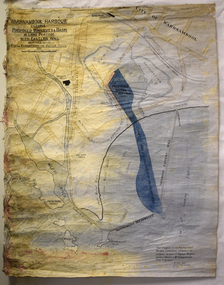
Map - Map of Proposed Alterations to Warrnambool Harbour 1925, Warrnambool Harbour Committee, Warrnambool Harbour Proposed Wharves and Basin in Lake Pertobe with Eastern Wall, 1925
This map was printed in 1925 and contains the Warrnambool Harbour alterations proposed by the Warrnambool Harbour Committee incorporating the original designs of Captain Menzies, the Warrnambool Harbour Master and the City Engineer, Mr A. Lavercombe. The main features of the proposal were the extension of the Eastern Wall to almost enclose the harbour and a basin in Lake Pertobe. The design was to be placed before the Victorian Royal Commission on the Outer Ports which was established partly to examine the allegations of unsatisfactory work carried out in Warrnambool when the Breakwater was extended 300 feet in 1914 and also to make recommendations regarding all regional ports. The Warrnambool Breakwater was completed in 1890 but failed to provide the shipping conditions needed to continue Warrnambool as a viable port. Many plans and proposals for port improvement such as this one were produced in the late 19th century and the first half of the 20th century with the port officially closed in the 1940s. Still today the Breakwater and Warrnambool Harbour conditions remain a source of contention.This map is significant as it shows a 1925 design for Warrnambool Harbour hitherto little-known. It also has markings showing land sites of the time (BayView Hotel, Woollen Mill etc.)This is a map made of thick yellow paper pasted onto a cloth backing. It has two cloth tags at the top for tying up the map when folded. It appears to be a hand-drawn map copied with printed material added. The map is shaded green and red in some areas. Attached by nails to the map are wooden frames, rounded at the bottom and partly curved at the top. The map is torn and partly detached at the top. The top frame has a cord attached for hanging the map.warrnambool harbour, captain menzies, a.lavercombe city engineer, warrnambool breakwater, royal commission on outer ports -
 Eltham District Historical Society Inc
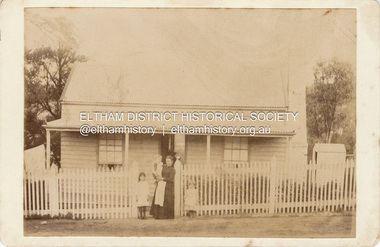
Photograph, Believed to be Sarah Aldous (nee Shillinglaw) with children, Florence, Elizabeth and Percival, c.1888
House at Diamond Creek Aldous Percival John : SERN DEPOT 160 : POB Melbourne VIC : POE Melbourne VIC : NOK F Aldous Charles https://recordsearch.naa.gov.au/SearchNRetrieve/Interface/DetailsReports/ItemDetail.aspx?Barcode=3024310&isAv=N Percival John Aldous was killed in action 19 Aug 1915 at Gallipoli CABINET 1866-1905 The Cabinet photo was introduced in 1866 in answer to a demand for a larger format photograph which could be mounted for a cabinet or on the wall. They were 4.5 inches by 6.5 inches (11.5 x 16.5 cm), more than twice the size of the cdv. They cost about twice as much as a cdv but eventually displaced them. They were not extensively produced until 1880 and had ceased by 1905. Coloured mounts, especially maroon or green, indicate a date between 1880 and 1890. - Frost, Lenore; Dating Family Photos 1850-1920; Valiant Press Pty. Ltd., Berwick, Victoria 1991marg ball collection, shillinglaw family photo album 2, 1888, cabinet photo, elizabeth annie aldous, florence may aldous, house, percival john aldous, sarah aldous (nee shillinglaw 1854-1925) -
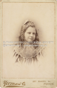 Eltham District Historical Society Inc
Photograph, Believed to be Jean Watson, c.1918
Jean Watson born 1906 was the only child of Christopher and Carrie Watson (nee Shillinglaw). She died at age 14 in 1920 as a result of an accident, cause as yet unknown. According to the Sands Melbourne and Victorian directories, Yeoman and Co operated from 287 Chapel Street, Prahran from c.1890-1923. CABINET 1866-1905 The Cabinet photo was introduced in 1866 in answer to a demand for a larger format photograph which could be mounted for a cabinet or on the wall. They were 4.5 inches by 6.5 inches (11.5 x 16.5 cm), more than twice the size of the cdv. They cost about twice as much as a cdv but eventually displaced them. They were not extensively produced until 1880 and had ceased by 1905. Coloured mounts, especially maroon or green, indicate a date between 1880 and 1890. - Frost, Lenore; Dating Family Photos 1850-1920; Valiant Press Pty. Ltd., Berwick, Victoria 1991cabinet photo, marg ball collection, jean watson (1906-1920), shillinglaw family photo album 3, 1890-1923, 1913, yeoman & co photographer 287 chapel st prahran -
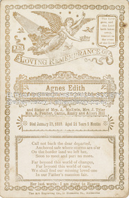 Eltham District Historical Society Inc
Photograph, The Art Engraving Company, Memorial Card: Agnes Edith Hill, 1899
Died January 29, 1899 aged 21 years 9 months Daughter of John and Esther (nee Lewis) Hill Sister to Phoebe Jane, Caroline Elizabeth, Emily Isabella and Albert Richard Ftizsimmons Hill Memorial Cards were commonly handed out to those friends and family paying their respects at the loss of a loved one. CABINET 1866-1905 The Cabinet photo was introduced in 1866 in answer to a demand for a larger format photograph which could be mounted for a cabinet or on the wall. They were 4.5 inches by 6.5 inches (11.5 x 16.5 cm), more than twice the size of the cdv. They cost about twice as much as a cdv but eventually displaced them. They were not extensively produced until 1880 and had ceased by 1905. Coloured mounts, especially maroon or green, indicate a date between 1880 and 1890. - Frost, Lenore; Dating Family Photos 1850-1920; Valiant Press Pty. Ltd., Berwick, Victoria 1991cabinet photo, marg ball collection, memorial card, shillinglaw family photo album 3, the art engraving company, 1899, agnes edith hill -
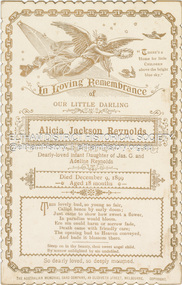 Eltham District Historical Society Inc
Photograph, The Australian Memorial Card Company, Memorial Card: Alicia Jackson Reynolds, 1899
Dearly loved infant daughter of James G.Reynolds and Adeleine (nee Kidd). Died December 9, 1899 aged 18 months. Adeleine Reynolds was the daughter of William Kidd and Sarah Ann Bird Memorial Cards were commonly handed out to those friends and family paying their respects at the loss of a loved one. CABINET 1866-1905 The Cabinet photo was introduced in 1866 in answer to a demand for a larger format photograph which could be mounted for a cabinet or on the wall. They were 4.5 inches by 6.5 inches (11.5 x 16.5 cm), more than twice the size of the cdv. They cost about twice as much as a cdv but eventually displaced them. They were not extensively produced until 1880 and had ceased by 1905. Coloured mounts, especially maroon or green, indicate a date between 1880 and 1890. - Frost, Lenore; Dating Family Photos 1850-1920; Valiant Press Pty. Ltd., Berwick, Victoria 1991cabinet photo, marg ball collection, shillinglaw family photo album 3, memorial card, the australian memorial card company, 1899, adeline reynolds, alicia jackson reynolds, james g. reynolds -
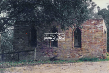 Eltham District Historical Society Inc
Photograph, Old dairy onthe Brinkkotter farm, Research, Vic, Jul. 2001
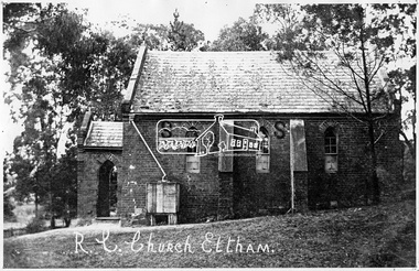
The original St Mary’s Roman Catholic Church (1865-1912) was built of clay brick with buttress walls and a slate roof on the corner of Fordhams Road and Maria Street (Main Road), Eltham South, opposite the present-day Wingrove Park. It was blessed on September 3, 1865. With the arrival of the railway in 1901 and the town centre moving closer to the station, the decision was made to relocate the site of the church to its present-day location on Henry Street at the corner of Main Road. A new timber weatherboard church, also called St Mary's was erected and blessed on October 13, 1912. The church and land cost £1,400 (Evelyn Observer). The original brick church was demolished in the 1920s and the bricks and windows were recycled to build a dairy on the Brinkkotter farm at Research. The timber church was destroyed by fire in 1961 and a new modern architectural (1960s) style church was erected in its place and named Our Lady of Help Christians Church.Colour photographresearch (vic.), brinkkotter, catholic church, eltham, roman catholic church, st marys catholic church -
 Eltham District Historical Society Inc
Negative - Photograph, Tom Prior, St Mary's Roman Catholic Church, Eltham, c.1900
The original St Mary’s Roman Catholic Church (1865-1912) was built of clay brick with buttress walls and a slate roof on the corner of Fordhams Road and Maria Street (Main Road), Eltham South, opposite the present-day Wingrove Park. It was blessed on September 3, 1865. With the arrival of the railway in 1901 and the town centre moving closer to the station, the decision was made to relocate the site of the church to its present-day location on Henry Street at the corner of Main Road. A new timber weatherboard church, also called St Mary's was erected and blessed on October 13, 1912. The church and land cost £1,400 (Evelyn Observer). The original brick church It was demolished in the 1920s and the bricks and windows were recycled to build a dairy on the Brinkkotter farm at Research. The timber church was destroyed by fire in 1961 and a new modern architectural (1960s) style church was erected in its place and named Our Lady of Help Christians Church.This photo forms part of a collection of photographs gathered by the Shire of Eltham for their centenary project book,"Pioneers and Painters: 100 years of the Shire of Eltham" by Alan Marshall (1971). The collection of over 500 images is held in partnership between Eltham District Historical Society and Yarra Plenty Regional Library (Eltham Library) and is now formally known as the 'The Shire of Eltham Pioneers Photograph Collection.' It is significant in being the first community sourced collection representing the places and people of the Shire's first one hundred years. The Reynolds family were early settlers in Research. The Reynolds/ Prior collection of photographs were taken by Tom Prior, the maternal uncle of Ivy Reynolds, around 1900 and the 60 photos in the album give a fine overview of many of the landmarks of Research and Eltham over 100 years ago. lvy lived in the family home for many years at 106 Thompson Cres Research. Ivy's father, Ernst Richard Reynolds and grandfather, Richard Reynolds, lived at the same address. Ivy's father Richard worked for Mr. Trail on his property in Research. Reynolds Road is named after the family. Mr Tom Prior (wife Eva) worked at the Melbourne zoo. He was very innovative and made his own camera, using the black cloth hood to exclude the light. The photographs are a reminder of the rural nature of Research and Eltham and its rich heritage.Digital image 4 x 5 inch B&W Negsepp, shire of eltham pioneers photograph collection, eltham, roman catholic church, brinkkotter, catholic church, church, reynolds prior collection, st marys catholic church -
 Kiewa Valley Historical Society
Photograph Tawonga Hotel, Tawonga Hotel Circa 1940s - 1950s, circa 1940s to 1950s
This photograph shows the "lay back" atmosphere enjoyed in a small country town in the 1940s to the 1950s. Two women and a young boy basking in the warmth of the sun. The unsealed drive way and cars parked close to the entrance was typical of small towns during this period. Open doors and shady trees provided sufficient cooling for most sunny days. The wooden barrel next to the outside wall shows that storage space within the hotel was limited and that metal aluminium barrels had not been in existence. This photograph was taken at a time when children and women had limited access to the major drinking and entertainment facilities within a hotel(pub). Legal drinking age was for patrons 21 years and older and no strict dress codes where applied. The hotel bar was not open on Sundays (God fearing) and opening time restrictions were in place. "In transit" clients were given some leniency when staying in small country hotels as strict liquor laws This photograph presents a window to a life in the 1940s to 1950s, of a small town in the Kiewa Valley. It covers a period when the local hotel or "pub" was the meeting point for local men and women to talk about local events and life in general. It was also a point where "locals' had the first opportunity to meet new arrivals and converse with tourists and "through traffic". The importance of "face to face" verbal communication was a critical part of community life and interaction. The hotel(pub) was in this period the hub of small communities, and together with local churches provided the essential structure for a balanced existence in rural Australia.Black and white photo of Tawonga Hotel. This photo is in itself a photo of a photo and as such lacks fine detail. This reproduction is on "Kodak XtraLife II paper ""outback" hotels, pubs, rural short stay accommodation, tawonga hotel -
 Eltham District Historical Society Inc
Postcard - Photograph, St Mary's Catholic Church, cnr Main Road and Henry Street, Eltham, c.1912
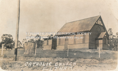
The original St Mary’s Roman Catholic Church (1865-1912) was built of clay brick with buttress walls and a slate roof on the corner of Fordhams Road and Maria Street (Main Road), Eltham South, opposite the present-day Wingrove Park. It was blessed on September 3, 1865. With the arrival of the railway in 1901 and the town centre moving closer to the station, the decision was made to relocate the site of the church to its present-day location on Henry Street at the corner of Main Road. A new timber weatherboard church, also called St Mary's was erected and blessed on October 13, 1912. The church and land cost £1,400 (Evelyn Observer). The original brick church It was demolished in the 1920s and the bricks and windows were recycled to build a dairy on the Brinkkotter farm at Research. The timber church was destroyed by fire in 1961 and a new modern architectural (1960s) style church was erected in its place and named Our Lady of Help Christians Church.PostcardReturn to Garnet Burges, Judge Bookchurches, catholic churches, st marys, main road, henry street, eltham -
 Eltham District Historical Society Inc
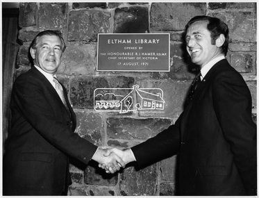
Photograph, Opening of Eltham Library, 17 Aug 1971
Official opening of Eltham Library; The Hon. Rupert. J. Hamer, E.D., M.P. (left) and Cr. G.C. Dreverman (right), 17 August 1971, in front of a plaque reading "Eltham Library opened by the Honourable R. J. Hamer E.D., M.P. Chief Secretary of Victoria, 17 August 1971" on the exterior bluestone wall. The Eltham Branch of the Heidelberg Regional Library Service was opened on 17 August 1971 by Victoria’s Chief Secretary R. J. Hamer. The library was designed by the firm Leith and Bartlett and was the southern wing of the Shire of Eltham Offices in Main Road Eltham. Visitors entered a “book plaza” which embodies the display techniques of a bookshop. Through this area was located a quieter area for reference and the more “purposeful” reader. The library was opened as part of the Shire of Eltham’s centenary celebrations. The library and Shire Offices were demolished exactly 25 years later in 1996. The current library was opened in 1994. This photo forms part of a collection of photographs gathered by the Shire of Eltham for their centenary project book, "Pioneers and Painters: 100 years of the Shire of Eltham" by Alan Marshall (1971). The collection of over 500 images is held in partnership between Eltham District Historical Society and Yarra Plenty Regional Library (Eltham Library) and is now formally known as 'The Shire of Eltham Pioneers Photograph Collection.' It is significant in being the first community sourced collection representing the places and people of the Shire's first one hundred years.Digital imagesepp, shire of eltham pioneers photograph collection, shire of eltham, shire of eltham centenary, eltham library, opening day, cr. g.c. dreverman, the hon. r.j. hamer -
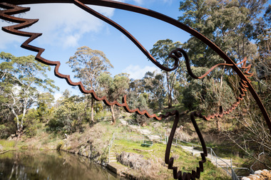 Hepburn Shire Council Art and Heritage Collection
Public Art Work, 'Bunjil' - Russell Petherbridge. 2012, 2012
'Hepburn Pool is a forgotten treasure which many visitors to Hepburn Springs would never be aware of. The owners of the Bellinzona Grange hotel explained that it was once the hotel pool and was built in the 1930's. You can find it behind this hotel, downhill at a street called The Pool Way. Steps and a ramp continue down to the pool itself and the secluded park around it. It was built into Spring Creek and became a competition pool for state swimming championships. A concrete weir separates a shallow children's pool from the main pool. You can still see the numbers of each lane painted on the walls at the deep end. There are plenty of seats and a barbeque area. A sign says this is a sacred aboriginal spot and you can certainly feel something magical about the place. I wouldn't suggest swimming in the former pool, it looks rather murky now.' Review of Hepburn Pool by 'Jolyon67' on 'Tripadvisor', 3 June 2015'The Bunji: The Bunjil sculpture emerged from discussions with local indigneous Elders, as a dreamtime totem to the Sacred Pool at Hepburn Springs. The original idea was to create the 3 totems of the area...the Bunjil, The Crow and The Bat. Russell applied for, a council grant of $3,000 to design, create and install the Bunjil Sculpture to overlook the pool and reflect its powerful image in the water.' Information provided by Russell Petherbridge, December 2015Large scale steel sculpture depicting 'Bunjil', the dreamtime totem of the Hepburn Pool, an eagle in flight.art, public art, sculpture, installation art, aboriginal art, site specific art, hepburn shire, hepburn shire public art collection, russell petherbridge, bunjil, hepburn, hepburn pool, aboriginal significance, steel sculpture -
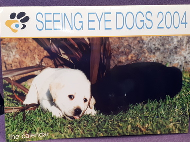 Vision Australia
Functional object - Object, Bartel, Seeing Eye Dogs 2004: the calendar, 2003
a13 month calendar featuring photos of Labrador puppies each month with the wording 'Did you know you can sponsor me or one of my friends? Simply call 1800 787 797'. Calendar has part of the monthly image reprinted on un-used days, and a monthly wall planner inserted in the middle of the calendar. On the back of the calendar, all images are featured as well as a final appeal from the organisation. "Love without the leash. 1800 Puppys - As irresistible as our puppies are, not everyone can care for one. That's why you can sponsor an adorable pup for as little as .50c a day. All contributions are tax deductible, so giving couldn't be easier. Simply call 1800Puppys (1800 787 797)". Common household items were often created to raise money for SEDA and to reinforce the work involved in training dogs from puppy to adult stage.Paper calendar with coloured photographsseeing eye dogs australia, fundraising -
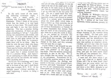 Melbourne Legacy
Document, Letter from GE Milne, Lone Pine ANZAC 18/12/1915, 1915
Black and white photocopy of a typed letter written by Company Sergeant Major (later Captain) George Eric Milne on the second last night at Lone Pine, Gallipoli. The letter to his parents show that he was scheduled to be in the second last party to leave the area during the evacuation. The other papers with this letter show that Legatee Don S (probably Simonson) had attended a planting of a Lone Pine seedling at Scotch College and the Head had read the letter out as part of the service. George Milne had attended school at Scotch College and is commemorated with his name on the wall of the Memorial Hall. From NAA his record shows that he had left Australia as part of the 24th Battalion (on the same ship as Legacy founder Stan Savige), he served at Gallipoli. Later with the 46th Battalion he was wounded in action and died in France on 5 April 1918, and is buried at Gezaincourt Communal Cemetery. Full text of the letter is transcribed and attached.A first hand account of the evacuation of Lone Pine from someone in the same battalion as Stan Savige.Black and white A4 photocopy x 5 pages of a typed letter written by GE Milne and associated research.gallipoli, world war one, george milne, evacuation -
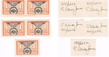 Bendigo Historical Society Inc.
Ephemera - MISS G ALICE JONES COLLECTION: WWII ONE GALLON FUEL RATION CARD, 31/05/1942
WWII One Gallon Fuel Ration Card: 5 x cream cards with blue flecks some attached with perforations in red and black print. At the top in red is "Motor Spirit Ration Ticket" issued under national security (liquid fuel) regulations. 1 One Gallon either side and at the bottom "This ticket must be endorsed by consumer with name and licence number". On a wall of circle shapes with Department of Supply and Development printed. In black ink in the centre is "Valid only until 31st May 1942 Not Transferable". Commonwealth Liquid Fuel Control Board is in a banner around the Commonwealth Emblem. On the back hand written in black ink is "2(e)/4652 G. Alice Jones".Printed by the Authority of the Government of the Commonwealth of Australiaww11. g. alice jones -
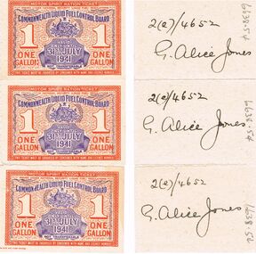 Bendigo Historical Society Inc.
Ephemera - MISS G ALICE JONES COLLECTION: WWII ONE GALLON FUEL RATION TICKET, 31/07/1941
WW1 One Gallon Fuel Ration Ticket: 3 x cream tickets attached. Red and blue print with perforated edges. A border of red print with a wall of circle shapes with Department of Supply and Development printed. At the top in the border is *Motor Spirit Ration Ticket. Issued Under National Security (Liquid Fuel) Regulations. In the centre is 1 One Gallon left and right. Underneath that is *This Ticket must be endorsed by consumer with name and licence number. Over print in blue is *Commonwealth Liquid Fuel Control Board, the Commonwealth Emblem with Valid only until 31st July 1941 Not Transferable. On the back hand written in black ink is 2(e)/4652 G. Alice Jones Box 625government, federal, fuel ration ticket -
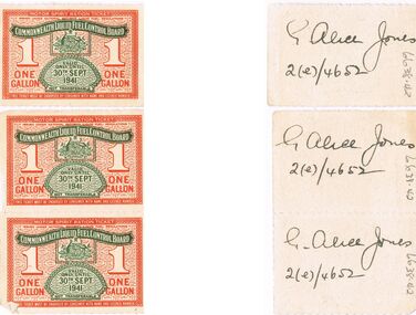 Bendigo Historical Society Inc.
Ephemera - MISS G ALICE JONES COLLECTION: WWII 1 GALLON FUEL RATION TICKETS
WWII 1 Gallon Fuel Ration Tickets: 3 x 1 gallon tickets on cream card with red and green print. Red background of a wall paper of oval shape and Department of Supply and Development. In red print at the top is "Motor Spirit Ration Ticket, issued under National Security (Liquid Fuel) Regulations". 1 One Gallon is in the centre and at the bottom is "This Ticket must be endorsed by consumer with name and licence number". Over printed in green is "Commonwealth Liquid Fuel Control Board, the Commonwealth Emblem and underneath is Valid only until 30th Sept 1941". On the back is "G. Alice Jones 2(e)/4652" on each ticket hand written in black ink.government, federal, fuel ration ticket -
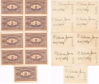 Bendigo Historical Society Inc.
Ephemera - MISS G ALICE JONES COLLECTION: WWII FUEL RATION 2 GALLON TICKETS
WWII Fuel Ration 2 Gallon Tickets: 9 Tickets of cream card with brown and blue print rectangular in shape with perforated edges. The back ground is a wall paper of small oval shapes with "Motor Spirit" printed in brown ink. Over top is "Commonwealth Liquid Fuel Control Board". In the centre, "Motor Spirit two 2 Gals not transferable Ration Ticket. Department of supply & Development. Issued Under National Security Act. 1939-40". Over top again in blue ink is covered in small lines and the words "Consumer must endorse this ticket on the back with signature and Licence number". On the back hand written in black ink is "G. Alice Jones 2(e)/3869".McCracken Australia Stamp Printedgovernment, federal, fuel ration ticket -
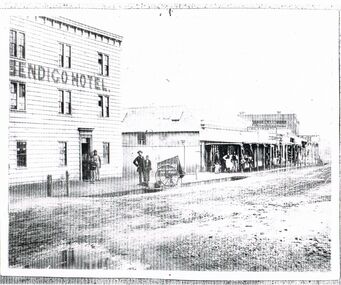 Bendigo Historical Society Inc.
Photograph - BLACK AND WHITE PHOTOGRAPH OF THE BENDIGO HOTEL
Black and white photograph of the Bendigo Hotel located in Bridge street. All nine windows are multi paned. There are two men and a boy standing in the doorway. Opposite the door stand and man and a boy near the cart belonging to Batchelder the Photographer. The man is wearing bowler hat. A corrugated iron fence spans the gap to the next building. The first building in the line is build using corrugated iron for the roof and walls. These retail establishments have a verandah along the footpath. A small group of retail staff are standing around watching the proceedings in the street. Two shops are name; J. Holdsworth and Glass & China warehouse. There may have been recent rain as the roadway appears to be puddled and quite damp.bendigo, history, buildings/streetscapes -
 Bendigo Historical Society Inc.
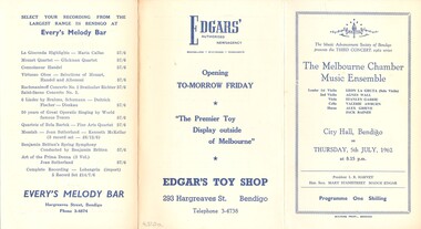
Document - THE MELBOURNE MUSIC CHAMBER MUSIC ENSEMBLE, CITY HALL, BENDIGO, 5 July
The Melbourne Music Chamber Music Ensemble, City Hall, Bendigo. The Music Advancement Society of Bendigo presents the Third Concert, 1962 series. Leader 1st Violin: Leon La Gruta (Solo Violin), 2nd Violin: Agnes Wall, Viola: Stanley Gabrie, Cello: Valerie Awburn, Horns: Alex Grieve & Jack Raines. Thursday, 5th July, 1962 at 8.15 p.m. President L R Harvey, Hon. Secs. Mary Stanistreet & Madge Edgar. Programme One Shilling. Advetisments: Allan's, Allan's Walk, Bendigo. Every's Melody Bar, Hargreaves Street, Bendigo. Edgars' Authorised Newsagency, 293 Hargreaves St. Bendigo. Copies A/ & B/ are the same.Boltons Print., Bendigoprogram, music, music advancement society bendigo, melbourne music chamber music ensemble, city hall, bendigo. music advancement society of bendigo third concert, 1962 series. leader 1st violin: leon la gruta (solo violin), 2nd violin: agnes wall, viola: stanley gabrie, cello: valerie awburn, horns: alex grieve & jack raines. 5th july. president l r harvey, hon. secs. mary stanistreet & madge edgar. advetisments: allan's, allan's. every's melody bar. edgars' newsagency. a/ & b/ are the same -
 Bendigo Historical Society Inc.
Book - VICTORIAN RAILWAYS RECORD OF DRILL SESSIONS ATTENDED 1956 - 1978
Brown paper covered book. On front cover on a label: Mr. T. Chafer, Foreman Boiler maker, Workshop Manager, Bendigo Nth. Inside front cover on an attached flimsy copy is a list of rules for the workshop drill implementation. e.g leader to make a note of nature of work performed at each drill, signed H.L. Wignall, Ambulance Officer. Book contains names of each person who attended a particular drill session, e.g 13.4.56, J. Smith, H. Latimer, N. Henderson, R. Walls, L. Smart, Dave Brown attended a 'poisons' drill session. Dates from 13.4.1956 to 23.5.1978. Also, at intervals in the book, is a summary of sessions attended for each employee.bendigo, railways, bendigo railways -
 Bendigo Historical Society Inc.
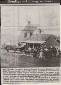
Newspaper - JENNY FOLEY COLLECTION: MALTHOUSE
Bendigo Advertiser "The way we were" from 1999. Malthouse: The Albion Brewery (Steward Brothers), Eaglehawk, circa 1900. The brewery dates back to 1853. James Steward was born in 1830 at Bury-St-Edmonds, Suffolk, England, and was educated in the brewing of ale before he boarded the American ship, the James L. Logert, bound for Australia in 1852. He made his way to the Bendigo diggings where he soon won his share of the precious metal until 1857 when he purchased a brewery in Letherby's Rd, Sailors Gully. The brewery covered five acres, had a house opposite with creeper covered walls and was described as one of the most attractive in the area.newspaper, bendigo advertiser, the way we were -
 Bendigo Historical Society Inc.
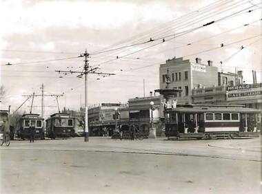
Photograph - PHOTOGRAPH OF CHARING CROSS 1938, October 1938
Black and White Photograph of Charing Cross October 1938. In the Photo are a number of Trams, some of the trams are about to move up High Street in the direction of Golden Square. Photographed are Trams 'No 16 Golden Square', '19 Lake Weeroona' and '13 Quarry Hill'. Off centre left shows the complexity of overhead wiring required to keep the trams moving. Far left man in dark clothing on bicycle. Tram employee standing in front of tram No. 16. Background right Herald, Age, and Leader newsagent signage. E.S.&A. Bank sign. Streader shoe signage. Centre two men leaning on bicycles at Fountain Fence. Taller building has signage for Trustee Company on wall.photograph, charing cross & trams, bendigo trams, bendigo tramways, trams, charing cross