Showing 10531 items
matching land
-
 Whitehorse Historical Society Inc.
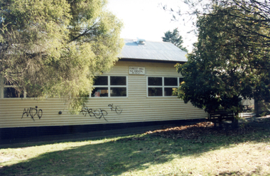
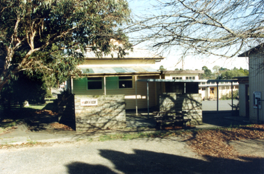
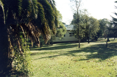
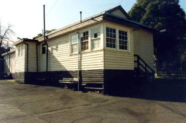
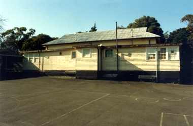
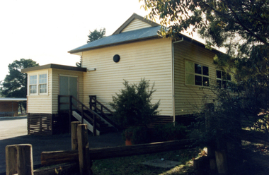
Photograph, Forest Hill State School, 1/08/1993 12:00:00 AM
School closed , demolished and land sold for housing .Coloured Photo of Forest Hill State School No. 4251.Springvale Road, Forest Hill. Since demolished. Part of a group of 24.forest hill state school.no. 4251 -
 Whitehorse Historical Society Inc.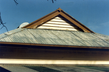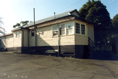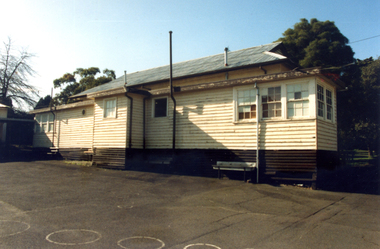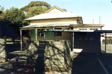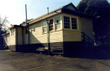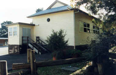
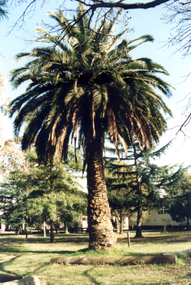
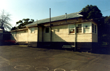
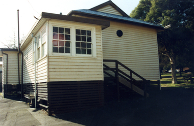
Photograph, Forest Hill State School, 1/08/1993 12:00:00 AM
School closed , demolished and land sold for housing .Coloured Photo of Forest Hill State School No. 4251.Springvale Road, Forest Hill. Since demolished. Part of a group of 24.forest hill state school. no. 4251 -
 Whitehorse Historical Society Inc.
Photograph, Forest Hill State School, 1/08/1993 12:00:00 AM
School closed , demolished and land sold for housing .Coloured Photo of Forest Hill State School No. 4251.Springvale Road, Forest Hill. Since demolished. Part of a group of 24.forest hill state school. no. 4251, school -
 Whitehorse Historical Society Inc.
Photograph, Forest Hill State School, 1/08/1993 12:00:00 AM
School closed , demolished and land sold for housing .Coloured Photo of Forest Hill State School No. 4251.Springvale Road, Forest Hill. Since demolished. Part of a group of 24.forest hill state school. no. 4251 -
 Whitehorse Historical Society Inc.
Photograph, Forest Hill State School, 1/08/1993 12:00:00 AM
School closed , demolished and land sold for housing .Coloured Photo of Forest Hill State School No. 4251.Springvale Road, Forest Hill. Since demolished. Part of a group of 24.forest hill state school. no. 4251, school -
 Whitehorse Historical Society Inc.
Photograph, Forest Hill State School, 1/08/1993 12:00:00 AM
School closed , demolished and land sold for housing .Coloured Photo of Forest Hill State School No. 4251.Springvale Road, Forest Hill. Since demolished. Part of a group of 24.forest hill state school. no. 4251, school -
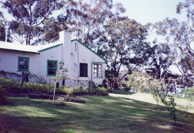 Lakes Entrance Regional Historical Society (operating as Lakes Entrance History Centre & Museum)
Photograph, 1999
Land became freehold, purchased by Jack Phillips.Colour photograph of a white painted brick residence with corrugated iron roof, sash windows, Set in bushland overlooking Lake Tyers, built on the site of the Mill Point saw mill at Mill Point Toorloo Arm Victoriahouses, heritage study -
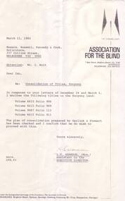 Vision Australia
Letter - Text, Letter regarding Consolidation of titles at Kooyong, 11/3/1982
Letter regarding the consolidation of land titles at Kooyong.1 photocopy of typed letterassociation for the blind, corporation records -
 Bendigo Historical Society Inc.
Photograph - The Young and Wirth Families at Preston Vale, near the Springs Sedgwick, 1880s-1900s
The Phil Wilkin Collection contains a series of 11 Items. The related items can be found by clicking on the reference link below. The following history of the Young family and their descendants who lived at the Springs is provided by Phil Wilkin. His Great Grandparents were Frances Young and August Wirth. Phil has also provided notes on the Wilkin Family and some history of the gold mining in Sedgwick. Frances Young's parents Joseph and Margaret Young owned the property called "The Old Place, Preston Vale or Wellington Flat" at Sedgwick near the Springs. Joseph Young owned and Managed the Standard Brewery which was located at Campbells Creek during the late 1800’s early 1900’s. Joseph and Margaret are buried in the Harcourt cemetery. In 1880 August Wirth lived at Mosquito Creek (Lake Eppalock, Victoria) when he married Frances Young. In 1902 they moved to part of Joseph Young's property. They milked cows and sold cattle for a living. One of their children Charles Wirth (Phil Wilkin's Grandfather) bought the land in 1935 after his parents had died. Charles Wirth was a councillor and also was president of the Shire of Strathfieldsaye. The "Old Place" was part of the property owned by members of the family. The old house at the Springs was burnt out by bushfire in January 1944 and much of the stonework was later vandalized by campers. The original Coliban Water Works were designed in 1863 by the Irish engineer Joseph Brady. The system included 70 kilometres of open water channels, aqueducts, syphons and tunnels to carry water (by gravity) from the Coliban River at Malmsbury, north to Castlemaine and Bendigo. Sedgwick is a locality in Central Victoria, Australia. It is located in the City of Greater Bendigo. Facilities include a public hall that opened in 1958 and CFA Rural fire station. It was named Upper Emu Creek until 1901 when it was renamed as Sedgwick after British geologist Adam Sedgwick.Thirty Four Photos of Joseph Young's property near "The Springs" on the main Coliban water channel from Malmsbury to the Sandhurst Reservoir in Bendigo. This item contains family history of Joeph's descendant Charles Wirth, who was a councillor for the Shire of Strathfieldsaye. The water race descends through a concrete chute, and continues sharply around the contour of the hills. Once it descended into a syphon across the gully. The are 182 photos in this series and can be found at 8683.1 to 8683.11. The series also includes photos of the surrounding farming land and the remains of an old house. There are also some notes on the pioneers of the district.history, bendigo, coliban water, joseph brady, irrigation, the springs, sedgwick, charles wirth, preston vale, joseph and margaret young, standard brewery campbells creek harcourt, phil wilkin collection -
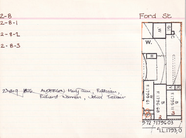
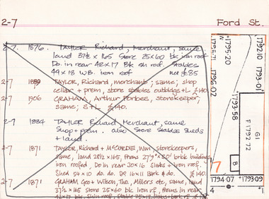 The Beechworth Burke Museum Research Collection
Card (Series) - Index Card, George Tibbits, Ford Street, Beechworth, 1976
George Tibbits, University of Melbourne. Faculty of Architecture, Building and Town & Regional PlanningIndex system that support the research for Beechworth : historical reconstruction / [by] George Tibbits ... [et al]Arranged by street names of BeechworthEach index card includes: street name and number of property, image of property, allotment and section number, property owners and dates of ownership, description of the property according to rate records, property floor plan with dimensions.beechworth, george tibbitsbeechworth, george tibbits -
 City of Moorabbin Historical Society (Operating the Box Cottage Museum)
Document, laminated List of Pioneers Moorabbin Parish, c1985
This list shows the names of the Pioneer settlers with the amount of Acres, the date purchased from The Crown and the Lot or Portion Number in the Land of the Henry Dendy Special Survey of Brighton 1841, in the County of Bourke , Victoria. The Squatters ,who arrived in the area first, used the land for grazing sheep and cattle. The Squatters had the right to graze unoccupied Crown land for ₤10 per year rental and a per capita payment for animals grazed. They could develop , improve and clear the land for the purpose of the tenancy but ownership was not permitted. When the land became useful The Crown put it on the market and the developers took over whilst the Squatters lost the improved land, dwellings and out buildings, there being no compensation paid. Squatters named John and Thomas Martin 1840-41; Richard and John King 1840- 1854 ; M.N.M.Moysey and M.J.Bickford 1841-1852 ; James McMahon 1846-1853 ; Daniel MacKinnon 1839- 1840. The 5120 Acres of the Henry Dendy Special Survey 1841were divided into approx. 83 Portions / Lots with varying acreage . Josiah Holloway, a speculator purchased 625 acres of the King Brothers run and re-sectioned the land into 2 acre Lots for Sale as market gardens. It was called The Two Acre Village later known as Cheltenham. A List of the names of The Pioneers in County of Burke Victoria c1841-1887 compiled by Lesley A. Schumer in 1985 A 3 Laminated display on wall in room 2 THE PIONEERS, Signed L.A. Schumer moorabbin, brighton, cheltenham, bentleigh, market gardeners, pioneers, early settlers, dendy henry, henry dendy's special survey 1841, squatters, king john, martin john, mcmahon james, two acre village, holloway josiah, were jonathan binn, grazing, cattle, sheep, market gardens, -
 Tatura Irrigation & Wartime Camps Museum
bottles, unknown
all bottles found in old well on site of old Bartlett's Cordial Factory on corner of Francis Street and Service Street, Tatura opposite Lake Bartlett in 1999 by owners of the land who were clearing land to build units9 bottles, 7 glass and 2 pottery - 1)pottery, colour stone & light tan, inscription in black "drink good old ginger beer brewed by J. Bartlett & Co Tatura" and "This bottle is the sole property of J.Bartlett & Co. and must not be used by any other persons."|2)pottery, colour stone & brown, inscription in black "drink good old ginger beer made by J. Bartlett & Co Tatura" and "This bottle is the sole property of J.Bartlett & Co. Tatura" Stamped into pottery is oval stamp with words "Govancroft of Glasgow" and the number 1.|3)clear glass bottle with inscription in glass "J.Bartlett & Co. J.B. Rushworth & Tatura" and "This bottle is the property of J.Bartlett & Co" and "Lemonade" and a small number 2. On base is "M5 29, a symbol and M".|4)clear glass bottle with inscription in glass "J.Bartlett & Co. J.B. Rushworth & Tatura" and "This bottle is the property of J.Bartlett & Co" and "Lemonade" and a small number 2. On base is "M5 29, a symbol and M".|5)green glass bottle with marble in neck with inscription in glass "J.Bartlett & Co. JB & Co Trade Mark Rushworth & Tatura" and "This bottle is the property of J.Bartlett & Co" and "Lemonade" . On base is letter "M".|6)green glass bottle with inscription in glass "J.Bartlett & Co. J.B. Rushworth & Tatura" and "This bottle is the property of J.Bartlett & Co" and a small number 4 . On the base is letters M750, M and ACM.|7)clear glass bottle with inscription in glass "J.Bartlett & Co. J.B. Rushworth & Tatura" and "This bottle is the property of J.Bartlett & Co". On base is ACM.|8)clear glass bottle with inscription in glass "J.Bartlett & Co. J.B. Rushworth & Tatura" and "This bottle is the property of J.Bartlett & Co" and small number 1. On base is M749, M and ACM.|9)clear glass bottle with fancy pattern on neck with inscription in glass "J.Bartlett & Co. J.B. Rushworth & Tatura" and "This bottle is the property of J.Bartlett & Co". On base is L567, M and ACM.tatura, bartlett, drink, bottle, glass, pottery, industry, smith, reynolds, technology, bottles, ceramics, stoneware -
 The Beechworth Burke Museum Research Collection
Card (Series) - Index Card, George Tibbits, 39 Ford Street, Beechworth, 1976
George Tibbits, University of Melbourne. Faculty of Architecture, Building and Town & Regional PlanningIndex system that support the research for Beechworth : historical reconstruction / [by] George Tibbits ... [et al]Arranged by street names of BeechworthEach index card includes: street name and number of property, image of property, allotment and section number, property owners and dates of ownership, description of the property according to rate records, property floor plan with dimensions.beechworth, george tibbitsbeechworth, george tibbits -
Federation University Historical Collection
Booklet, Education Department Victoria, Victorian Education Department Course of Study of primary Schools: Social Studies, 1954 and 1956
.1) 18 page booklet relating to the Victorian Education Department Course of Study of Primary Schools: Social Studies grades 1 to 6. Topics include family and home, how the community lives and works, Beyond the Neighbourhood (Africa, Canada, New Guinea, India, China, Italy, English factory town), The World About Me (School, home, food, clothes), Our Own Land (The Australia Our Ancestors Found - unknown interior, sheep, riches from underground, water, grain, cows, meat, tropics, tall timbers, manufacture, Melbourne, travel), The Land of Our Fathers (British Descent, From other Countries .2) Victorian Education Department Course of Study of primary Schools: Social Studies, Grades VII and VIII 6 page printed bookleteducation department, social studies, education -
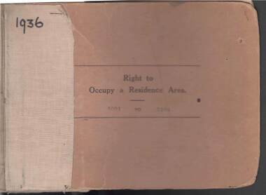 Bendigo Historical Society Inc.
Book - RIGHT TO OCCUPY RESIDENCE AREA COLLECTION: REGISTER 1936
COLLECTION OF RIGHT TO OCCUPY A RESIDENCE AREA -LAND (RESIDENCE AREAS ) Act 1935 / thick cardboard book -cloth and string binding / written on front in texter '1936' / numbers 5001 to 5100 / inside - stubs of documents showing Granted to , of, period, Date of Right , Description of Land , Allotment, Section, City, Town , Borough , Township of , Parish of , Authorised Person . Rubber stamps show The interest of this Right has been transferred to /one stub shows Department of Lands and Survey note on Bendigo Historical Society Catalogue Sheet dated 12.6.2008 All buts completed and original application forms removed. Note -forms were originally in triplicate on one page with serrations for removal of two parts; butts remain .Residence areas in Central Goldfields.Bendigo City Council - Acquisition 1990organization, government, official -
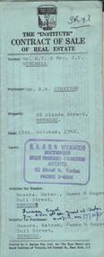 Bendigo Historical Society Inc.
Document - H.A. & S.R. WILKINSON COLLECTION: CONTRACT OF SALE
Contract of sale of real estate between Mr. R.T. & Mrs J.V. Mitchell (Vendor) and Mr. R.W. Stretton (purchaser) for property at 28 Olinda Street, Bendigo dated 12th October, 1962. Solicitor for vendor: Messrs Watson, James & Rogers - Bull Street Bendigo. Solicitor for purchaser: Messrs. Watson, James & Rogers of Bull Street, Bendigo. Sale of piece of land part of Crown allotment 6, section 68c land described in Certificate of title volume 4472, folio 399, together with a right of carriageway over the road coloured brown on the map drawn on the said certificate of title, together with all floor coverings, blinds, curtains, electric light fittings and shades, gas fire and gas copper. Price 1,850 pounds.organization, business, h.a. & s.r wilkinson real estate