Showing 7474 items
matching the road to lower plenty
-
 Greensborough Historical Society
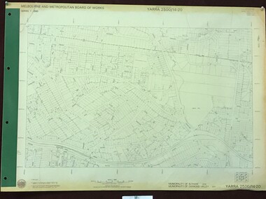
Map, Melbourne and Metropolitan Board of Works. Survey Division, MMBW, Yarra 2500 / 14.23. Diamond Creek, Sutherland Homes, 1979_05
... Greensborough Historical Society 34A Glenauburn Road Lower ...Melbourne and Metropolitan Board of Works. Yarra 2500 [base map] 14.23. Diamond Creek, Sutherland Homes. Parish of Morang 3183 and Nillumbik 3310. Municipality of Diamond Valley 257. Prominent streets Aqueduct Road, Diamond Creek Road, Yan Yean Road and McLaughlans Lane. Features include the abandoned Maroondah aqueduct and Sutherland Cottages.MMBW Map in 1:2500 [scale] series. Cream parchment with green tape reinforcing on edges and punched holes on left edge.mmbw, melbourne and metropolitan board of works, shire of diamond valley, plenty - maps, sutherland homes, maroondah aqueduct -
 Greensborough Historical Society
Map, Melbourne and Metropolitan Board of Works. Survey Division, MMBW, Yarra 2500 / 14.22. St Helena, St Katherine's Church, 1979_08
... Greensborough Historical Society 34A Glenauburn Road Lower ...Melbourne and Metropolitan Board of Works. Yarra 2500 [base map] 14.22. St Helena, St Katherine's Church. Parish of Nillumbik 3310. Municipality of Diamond Valley 257. Prominent streets St Helena Road, Weidlich Road, Yan Yean Road and Allumba Drive. Features include St Katherine's Church of England and the St Helena Secondary College site.MMBW Map in 1:2500 [scale] series. Cream parchment with green tape reinforcing on edges and punched holes on left edge.mmbw, melbourne and metropolitan board of works, shire of diamond valley, st helena - maps, st katherines church st helena -
 Greensborough Historical Society
Map, Melbourne and Metropolitan Board of Works. Survey Division, MMBW, Yarra 2500 / 14.21. St Helena, Weidlich Road, 1979_08
... Greensborough Historical Society 34A Glenauburn Road Lower ...Melbourne and Metropolitan Board of Works. Yarra 2500 [base map] 14.21. St Helena, Weidlich Road. Parish of Nillumbik 3310. Municipality of Diamond Valley 257. Prominent streets St Helena Road, Weidlich Road, Karingal Drive and Progress Road. Features include the Blair Reserve.MMBW Map in 1:2500 [scale] series. Cream parchment with green tape reinforcing on edges and punched holes on left edge.mmbw, melbourne and metropolitan board of works, shire of diamond valley, st helena - maps -
 Greensborough Historical Society
Map, Melbourne and Metropolitan Board of Works. Survey Division, MMBW, Yarra 2500 / 14.20. Montmorency, Sherbourne Road, 1977_06
... Greensborough Historical Society 34A Glenauburn Road Lower ...Melbourne and Metropolitan Board of Works. Yarra 2500 [base map] 14.20. Montmorency, Sherbourne Road. Municipality of Diamond Valley 257 and Eltham 238. Prominent streets: Sherbourne Road, Karingal Drive and Calrossie Avenue. Features include Montmorency Station and Meruka Park.MMBW Map in 1:2500 [scale] series. Cream parchment with green tape reinforcing on edges and punched holes on left edge.mmbw, melbourne and metropolitan board of works, shire of diamond valley, montmorency - maps -
 Greensborough Historical Society
Map, Melbourne and Metropolitan Board of Works. Survey Division, MMBW, Yarra 2500 / 13.28. Mernda, Wilton Vale, 1977_08
... Greensborough Historical Society 34A Glenauburn Road Lower ...Melbourne and Metropolitan Board of Works. Yarra 2500 [base map] 13.28. Mernda, Wilton Vale. Municipality of Diamond Valley 257 and Whittlesea 239. Prominent streets: Wilton Vale Road. Features include Yan Yean Pipe Track and SEC Transmission Lines. The abandoned rail line (old Whittlesea line) is in the top left corner.MMBW Map in 1:2500 [scale] series. Cream parchment with green tape reinforcing on edges and punched holes on left edge.mmbw, melbourne and metropolitan board of works, shire of diamond valley, mernda - maps -
 Greensborough Historical Society
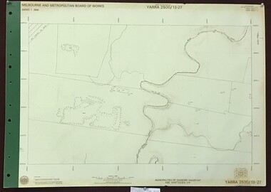
Map, Melbourne and Metropolitan Board of Works. Survey Division, MMBW, Yarra 2500 / 13.27. Morang wetlands, 1977_09
... Greensborough Historical Society 34A Glenauburn Road Lower ...Melbourne and Metropolitan Board of Works. Yarra 2500 [base map] 13.27. Morang wetlands. Municipality of Diamond Valley 257 and Whittlesea 239. Features include the Plenty River and SEC Transmission Line easement. MMBW Map in 1:2500 [scale] series. Cream parchment with green tape reinforcing on edges and punched holes on left edge.mmbw, melbourne and metropolitan board of works, shire of diamond valley, morang - maps -
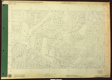
 Greensborough Historical Society
Map, Melbourne and Metropolitan Board of Works. Survey Division, MMBW, Yarra 2500 / 14.25. Plenty, Heard Road, 1978_02
... Greensborough Historical Society 34A Glenauburn Road Lower ...Melbourne and Metropolitan Board of Works. Yarra 2500 [base map] 14.25. Plenty, Heard Road. Parishes of Greensborough 2724, Nillumbik 3310 and Morang 3183. Municipality of Diamond Valley 257. Prominent streets include: Heard Road, Seymour Drive and Yan Yean Road.MMBW Map in 1:2500 [scale] series. Cream parchment with green tape reinforcing on edges and punched holes on left edge.mmbw, melbourne and metropolitan board of works, shire of diamond valley, plenty - maps -
 Greensborough Historical Society
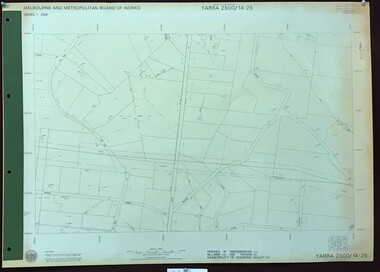
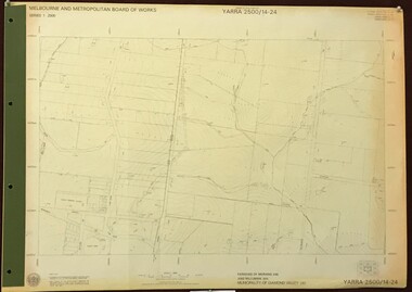
Map, Melbourne and Metropolitan Board of Works. Survey Division, MMBW, Yarra 2500 / 14.24. Plenty, 1979_05
... Greensborough Historical Society 34A Glenauburn Road Lower ...Melbourne and Metropolitan Board of Works. Yarra 2500 [base map] 14.24. Plenty. Parishes of Nillumbik 3310 and Morang 3183. Municipality of Diamond Valley 257. Prominent streets include: Heard Road, Hillmartin Road and Yan Yean Road. Features include Plenty Primary School and Plenty Park.MMBW Map in 1:2500 [scale] series. Cream parchment with green tape reinforcing on edges and punched holes on left edge.mmbw, melbourne and metropolitan board of works, shire of diamond valley, plenty - maps -
 Greensborough Historical Society
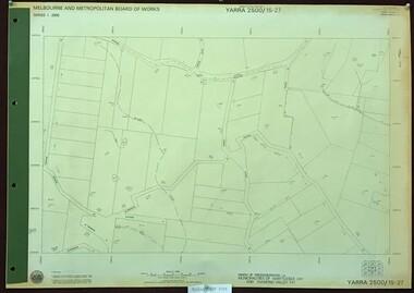
Map, Melbourne and Metropolitan Board of Works. Survey Division, MMBW, Yarra 2500 / 15.27. Yarrambat, De Fredricks Lane, 1977_10
... Greensborough Historical Society 34A Glenauburn Road Lower ...Melbourne and Metropolitan Board of Works. Yarra 2500 [base map] 15.27. Yarrambat, De Fredricks Lane. Parish of Greensborough 2724. Municipality of Diamond Valley 257 and Whittlesea 239. Prominent streets include: De Fredricks Lane, Astons Road and Bannons Lane. Features include Scrubby Creek.MMBW Map in 1:2500 [scale] series. Cream parchment with green tape reinforcing on edges and punched holes on left edge.mmbw, melbourne and metropolitan board of works, shire of diamond valley, yarrambat - maps -
 Greensborough Historical Society
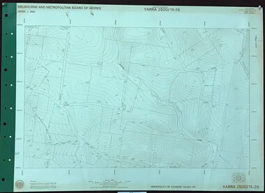
Map, Melbourne and Metropolitan Board of Works. Survey Division, MMBW, Yarra 2500 / 15.26. Yarrambat, Hacketts Road, 1978_07
... Greensborough Historical Society 34A Glenauburn Road Lower ...Melbourne and Metropolitan Board of Works. Yarra 2500 [base map] 15.26. Yarrambat, Hacketts Road. Municipality of Diamond Valley 257. Prominent streets include: Black Gully Road, Hacketts Road and Collins Lane. Features include Scrubby Creek.MMBW Map in 1:2500 [scale] series. Cream parchment with green tape reinforcing on edges and punched holes on left edge.mmbw, melbourne and metropolitan board of works, shire of diamond valley, yarrambat - maps -
 Greensborough Historical Society
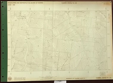
Map, Melbourne and Metropolitan Board of Works. Survey Division, MMBW, Yarra 2500 / 15.25. Yarrambat, Black Gully Road, 1978_07
... Greensborough Historical Society 34A Glenauburn Road Lower ...Melbourne and Metropolitan Board of Works. Yarra 2500 [base map] 15.25. Yarrambat, Black Gully Road. Municipality of Diamond Valley 257. Prominent streets include: Black Gully Road, Ironbark Road and Murray Road. MMBW Map in 1:2500 [scale] series. Cream parchment with green tape reinforcing on edges and punched holes on left edge.mmbw, melbourne and metropolitan board of works, shire of diamond valley, yarrambat - maps -
 Greensborough Historical Society
Map, Melbourne and Metropolitan Board of Works. Survey Division, MMBW, Yarra 2500 / 15.24. Diamond Creek, Grassy Flat Road, 1978_02
... Greensborough Historical Society 34A Glenauburn Road Lower ...Melbourne and Metropolitan Board of Works. Yarra 2500 [base map] 15.24. Diamond Creek, Grassy Flat Road. Parish of Nillumbik 3310. Municipality of Diamond Valley 257. Prominent streets include: Everleigh Drive, Broad Gully Road and Clyde Street. Features include the Diamond Creek, Nillumbik Park and Diamond Creek Reservoir.MMBW Map in 1:2500 [scale] series. Cream parchment with green tape reinforcing on edges and punched holes on left edge.mmbw, melbourne and metropolitan board of works, diamond creek - maps, shire of diamond valley -
 Greensborough Historical Society
Newspaper Clipping, Diamond Valley Leader, Hell On Wheels: Cyclists safety concerns, 06/03/2019
... Greensborough Historical Society 34A Glenauburn Road Lower ...Diamond Valley cyclists are calling for better safety as they negotiate one of the area's busiest roads. A bike lane needs to be continuous along Main Road Eltham. News article 1 page, black text.eltham, diamond creek, greensborough, cyclists, bike lanes -
 Greensborough Historical Society
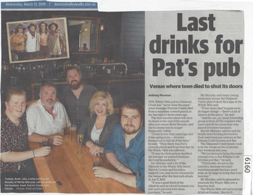
Newspaper Clipping, Diamond Valley Leader, Last drinks for Pat's pub, 13/03/2019
... Greensborough Historical Society 34A Glenauburn Road Lower ...The Windy Mile pub in Diamond Creek has 'never been the same" since teenager Patrick Cronin died from a senseless coward punch at the bar almost three years ago.The Windy Mile will serve its last drink on Sunday, March 31 2019.News article 1 page, black text.windy mile, diamond creek, patrick cronin, cronin family -
 Greensborough Historical Society
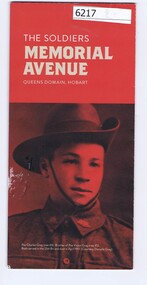
Pamphlet, The Soldiers Memorial Avenue, Queens Domain, Hobart, 2015_
... Greensborough Historical Society 34A Glenauburn Road Lower ...History, description and maps of the Soldiers Memorial Avenue Hobart. Includes map, with location of memorial trees.Single sheet printed in colour both sideswar memorials, hobart -
 Greensborough Historical Society
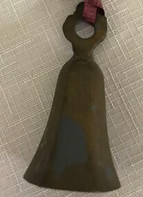
Bell, Brass bell, 1920s
... Greensborough Historical Society 34A Glenauburn Road Lower ...Ornamental brass bellOrnamental brass bell, Benares ware, with iron tonguebell -
 Greensborough Historical Society
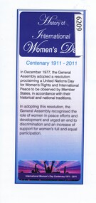
Leaflet, History of International Women's Day: Centenary 1911-2011, 2011_
... Greensborough Historical Society 34A Glenauburn Road Lower ...Short history of International Women's Day, presented to participants in the IWD Dinner 2011.Leaflet, printed in colour both sides, laminatedinternational womens day -
 Greensborough Historical Society
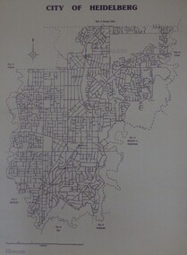
Maps, City of Heidelberg 1989, 1989_05
... Greensborough Historical Society 34A Glenauburn Road Lower ...Map of City of Heidelberg as at 18/11/1994Blueprint, Scale 1km: 8 cmcity of heidelberg, heidelberg -
 Greensborough Historical Society
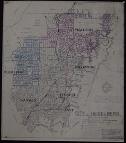
Maps, City of Heidelberg 1974, 1974c
... Greensborough Historical Society 34A Glenauburn Road Lower ...City of Heidelberg showing Municipal and Ward boundaries, prepared by City Engineers Department. Made for Council use; copies available for sale to the public.Blueprint, 2 copies, one with some roads hand coloured, showing municipal and ward boundaries. Scale: 20 chains to 1 inchG. M. Hutchins. Authorised charge 50c.city of heidelberg, heidelberg -
 Greensborough Historical Society
Booklet, AWA (Amalgamated Wireles (Australasia) Limited), AWA Deep Image Television Receiver, Instructions, 1972_06
... Greensborough Historical Society 34A Glenauburn Road Lower ...Owner's manual for the Deep Image Television Receiver (1970s).8 p., black and white text and illusrations.television, owners manuals -
 Greensborough Historical Society
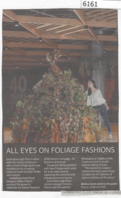
Newspaper Clipping, Diamond Valley Leader, All Eyes on Foliage Fashions, 20/03/2019
... Greensborough Historical Society 34A Glenauburn Road Lower ...Greensborough Plaza is alive with the colours of autumn after a fresh foliage gown was installed at the shopping centre to mark the start of the new season.News article 1 page, black text.greensborough plaza, colours of autumn, gillian pollard -
 Greensborough Historical Society
Article - Website, National Trust of Australia (Victoria), Mont Park: Statement written by National Trust of Australia (Victoria), 17/09/2010
... Greensborough Historical Society 34A Glenauburn Road Lower ...Statement of Cultural heritage Significance for Mont Park acquired by Victorian state government in 1909 and used as a mental hospital complex comprising Larundel Kingsbury and Greswell facilities, finally decommissioned in1969. Contains extensive descriptions of regionally significant indigenous and exotic vegetation, landscaped by designer Hugh Linaker.2p. typescriptmont park, larundel, gresswell, hugh linaker -
 Greensborough Historical Society
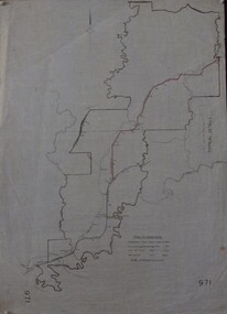
Maps, Shire of Heidelberg, 1920s
... Greensborough Historical Society 34A Glenauburn Road Lower ...Map of main roads within Shire of Heidelberg, probably those for which the Shire was responsible for maintainingMap of main roads within Shire of Heidelberg, hand coloured, and Hurstbridge rail line. 40 chains: 1 inch971shire of heidelberg, heidelberg -
 Greensborough Historical Society
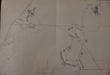
Maps, Mont Park, Gresswell, Larundel, 01/08/1949
... Greensborough Historical Society 34A Glenauburn Road Lower ...Map of Mont Park area, including Larundel, Gresswell and Kingsbury Farm, between Plenty Road and Waiora Road, as at 1949, including buildings. Map of Mont Park area, including Larundel, Gresswell and Kingsbury Farm. Ink & pencil. Scale: 200': 1 inch49/147, R. G. H.mont park, larundel, gresswell watsonia, kingsbury -
 Greensborough Historical Society
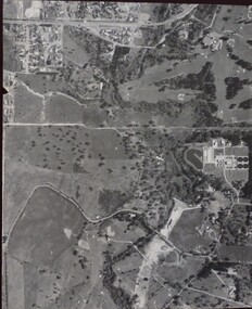
Aerial Photograph, Banyule Road / Lower Plenty Road, 1972c
... Banyule Road / Lower Plenty Road...Viewbank, Rosanna and Lower Plenty area, showing Lower... Plenty Lower Plenty melbourne Aerial Photograph Banyule Road ...Viewbank, Rosanna and Lower Plenty area, showing Lower Plenty Road and Banyule RoadAerial survey photograph, black and whiteviewbank -
 Greensborough Historical Society
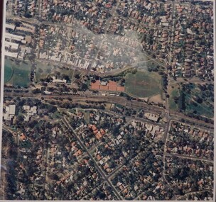
Aerial Photograph, Macleod, 1980c
... Greensborough Historical Society 34A Glenauburn Road Lower ...Covers Macleod area. Section of 5994.Laminated colour aerial photographmacleod -
 Greensborough Historical Society
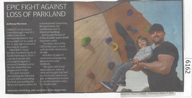
Newspaper Clipping, Diamond Valley Leader, Epic Fight Against Loss of Parkland, 27/03/2019
... Greensborough Historical Society 34A Glenauburn Road Lower ...Families are flocking to Greensborough's new $13 million Civic Drive recreational precinct, but many might not be aware of the 12 year fight involved in ensuring its creation.News article 1 page, black text.greensborough, civic drive greensborough, playgrounds - greensborough, parks - greensborough -
 Greensborough Historical Society
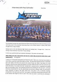
Article, Rosie Bray et al, Interview with Paul Schindler, by Rosie Bray, 2018_
... Greensborough Historical Society 34A Glenauburn Road Lower ...Interview with Paul Schindler, by Rosie Bray; with newspaper cutting "Games with positive impact", by Peter Taylor. Paul Schindler has been the coach of the Yarra Plenty Swimming Club and coached the Australian Swimming Team at the Invictus Games in Sydney 2018 5 p. typescript, with colour photos; with newspaper cuttingyarra plenty swimming club, paul schindler -
 Greensborough Historical Society
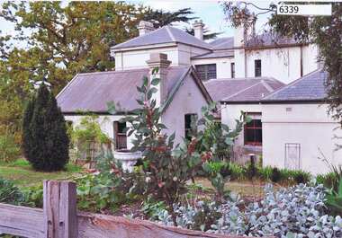
Photograph, Ian McLachlan, Yallambie House 2014, 2014_
... Greensborough Historical Society 34A Glenauburn Road Lower ...Photograph of Yallambie House, Tarcoola Drive GreensboroughColour photographyallambie homestead, yallambie -
![Newspaper Clipping, Hurstbridge Advertiser, Greensborough [1933], 13/04/1933](/media/collectors/4f729f5697f83e03086015b8/items/5cb7c7fe21ea6d10e4906526/item-media/5cbc311221ea670d00ab0d18/item-fit-380x285.jpg) Greensborough Historical Society
Greensborough Historical SocietyNewspaper Clipping, Hurstbridge Advertiser, Greensborough [1933], 13/04/1933
... Greensborough Historical Society 34A Glenauburn Road Lower ...Article with local Greensborough news about Grace Park Golf Club, Greensborough Football Club, Progress Association, Mother's Club, Greensborough Cricket Club and Scrivens Testimonial1 p. photocopy of article in Advertiser 13 April 1933greensborough, grace park golf club