Showing 3905 items matching "bricker"
-
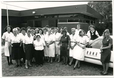 Royal District Nursing Service (now known as Bolton Clarke)
Photograph - Photograph, black and white, c.1980
This photograph is taken outside the Royal District Nursing Service (RDNS) Rosebud Centre which was opened in the mid 1970s. This photograph is a record of Rosebud RDNS staff in the 1980s. The Sisters are wearing their summer uniforms, some with white frocks with a blue pattern and a red belt, others with a white blouse with a red pattern on it and a royal blue skirt. The Health Aides uniform is a royal blue dress with white piping.Gradually over the years, Melbourne District Nursing Service (MDNS), later known as Royal District Nursing Service (RDNS), from 1966 when they received Royal patronage, opened Centres throughout the Melbourne Metropolitan area. Their Trained nurses (Sisters) left from these Centres each morning to carry out their nursing visits in a specific area,(district) taking any sterilized equipment needed with them. They returned at the end of the day to write up their patients nursing histories, clean and reset any equipment used ready for sterilization, and contact other medical and community personal as necessary. Most of the RDNS cars were housed at each Centre, only a few being driven home by a Sister. In 1980, a Home Health Aide ‘Pilot study’, funded by the Federal Government, the Brotherhood of St. Laurence and RDNS, with the program written and taught by RDNS Principal Nurse Educator. Pat (Paddy) Rowley was evaluated as successful. Following this Pilot study, Home Health Aides were employed by RDNS, and after instruction in the RDNS Education department, joined RDNS Centres and worked under the supervision of the RDNS Sisters. The Sister assessed each client, then introduced and supervised the Health Aide in the client procedure required. The Sister wrote out clear, concise procedural instructions on a work card which the Health Aid followed each visit. If the Health Aide noticed any change in the client’s condition, this was reported immediately and the Sister visited. The Sister made routine visits to the client for review at least monthly. Black and white photograph showing Royal District Nursing Service (RDNS), staff outside a brick building with a flat roof. A white RDNS car is on the right hand side of the photograph with "RDNS" in capital letters on the door. A tree is in the background. The twenty-five, some partly hidden, RDNS staff are wearing their uniforms. Some are wearing white patterned short sleeve dresses with a dark belt, and others white patterned short sleeve blouses and dark skirts. The letters "RDNS" are displayed in capital letter on the left hand upper pocket of the Sisters. Two Health-aides are present and are wearing dark coloured frocks with white piping. mdns, melbourne district nursing service, rdns, royal district nursing service, rdns centres -
 Tarnagulla History Archive
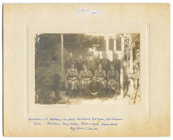
Photograph: (probably) 'Evening Strollers' Club, Tarnagulla, circa 1919
Donald Clark Collection. A sepia photograph of men and women posed in front of the verandahe entrance of a brick house. All of subjects were Tarnagulla residents. Most performed on more than one occasion as 'The Evening Strollers' in performances at the Victoria Theate, Tarnagulla. The matching outfits worn by the subjects in this photo may relate to this Club (The Strollers Club). Subjects are: L to R Back row: Alf Radnell, Clive Bock?, Clem Theobald, Syd Taylor, William 'Bill' Jackson Front row: Dolly Comrie, Daisy Jackson, Rachel / Rachael Clark, Dorrie Bock. Front seated on ground: Reg 'Skeeter' Smith. Original photograph, mounted on card. tarnagulla, entertainment, clubs, music, theatre -
 Bendigo Military Museum
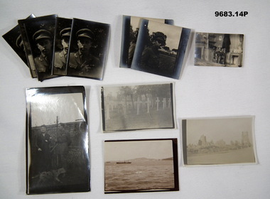
Photograph - VARIOUS PHOTOGRAPHS, WW1, C.1916 - 1919
These photos were in the collection relating to C.J.C. McQuie MM, refer Cat No 9680P for his service details. .1) - .7) Portraits are of McQuie MM. .8) .9) McQuie MM. .10) Identity unsure. .11) McQuie MM. .12) The first grave on the left is No 860 S.S. Scott 6th Bn, D.O.W's 12.6.1918..1) - .7) Six B & W portrait photos of an Officer in a peak Cap wearing ribbons one being the "MM". .8) - .9) Two B & W photos of an Officer with a building in the background. .10) B & W photo of an Officer sitting in a chair in a house. .11) B & W photo shows a Lady and an Officer with a brick wall in the background, the Officer is wearing ribbons and "A" for ANZAC on his shoulder patch. .12) B & W photo of a grave yard with 6 graves in one row. .13) Sepia photo of a bombed town. .14) Sepia photo showing a ship on the ocean with land in the background. photos, mcquie -
 Melbourne Tram Museum
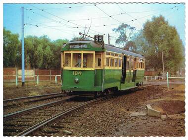
Postcard, Nu-color-Vue, L 104 on the Zoo line, 1980's
Full colour gloss finished postcard with a serrated edge of L 104 on the Zoo line, showing West Coburg via William St (route 55) as its destination. Photo has the Zoo brick wall in the background. On the rear of the card has the details of the tram type and the tramcar itself. Photographer (Ron Scholten). Produced by the TMSV in association with Nucolorvue. Has space for stamp and address details. NCV 1389 Used by Kevin Tierney to return a donator form and a note on the Hawthorn flyers distributed by the Connies at the Melbourne Town Hall on the 26 July 2014 Open House Day. 2 copies held.trams, tramways, l class, zoo tram, tram 104 -
 Bendigo Historical Society Inc.
Document - NORTH DEBORAH MINE - GT SOUTHERN ENGINE HOUSED AT NORTH DEBORAH MINE
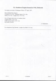
Handwritten notes and typed copies of same, on Great. Southern Engine housed at Nth Deborah. 'For details, see copy of Catalogue of Sale, 10th April, 1947. Have checked these figures:- Cylinders 22 in dia. Catalogue figures 24 in dia. Stroke 5 ft 0 ins. Length of cyl 5 ft 6 ins. Size of Engine Bed at the St Southern Mine. Length of Bed 23 ft 6 ins. Width across Centres 14 ft 2 ins. Bed made of bricks. A Richardson. For comparison, Big Deborah - Length of cylinder 3 ft 6 ins'. Albert Richardson Collection. document, gold, the north deborah gold mine co, north deborah mine, gt southern engine housed at north deborah mine, gt southern mine, a richardson, big deborah -
 Ballarat Heritage Services
Photograph - Church, Clare Gervasoni, Ebenezer St John's Presbyterian Church, 28/09/2020
Ebenezer Presbyterian Church is located in Armstrong Street South, Ballarat. The earliest church on the site was wooden church was and built in 1857 for the miners Gold Rush. In 1862 the wooden building was replaced by the bluestone church still in use today. The bluestone church was designed by architect Henry Richards Caselli in Lombardic Romanesque style. It features tall windows with paired round headed lights, buttresses and huge brackets. The porch and gallery were added in the 1880s to cater for an increase in the size of the congregation and are the only additions to the church. The 1880s porch features bracketted gables, finial, piers, string course and triple windows. The Ebenezer Church is important architecturally for its interior as well as its exterior, as it has a Classical Revival design that is both distinctive and unusual in Australia. The Ebenezer Presbyterian Church Hall built to the right of the church was constructed in 1892 and is made of locally produced red brick, which was more fashionable at the time. It too has been built in Lombardic Romanesque style in sympathy with the church building and features tall arched windows. The double-storey presbytery, built on the left of the church dates around the 1880s and is also constructed of red brick. Built in Victorian Classical Freestyle, it has elegant quoining on its corners, large windows upstairs, and prominent bay windows on the ground floor. The Armstrong Street facade is sheltered from the sun by a verandah and balcony featuring fine cast iron columns and lacework. The whole complex is surrounded by its 1880s cast iron paling fence. Henry Richards Caselli is perhaps best known in Ballarat for the large number of churches in Victoria that he designed, with two Lombardic Romanesque examples in Ballarat, the Ebenezer Presbyterian church, Armstrong Street South between 1862 and 1863 and the Lutheran Church in Doveton Street in 1876. This photograph was taken during the Covid19 pandemic and the associated shutdowns.Colour photographs of Ebenezer St John's Presbyterian Church.ebenezer st john's presbyterian church, ebenezer, church, ballarat, henry richards caselli -
 Surrey Hills Historical Society Collection
Photograph, Grovedale Road Quarry in the 1920s - looking south, c1920
The quarry was part of John Butler Maling's property. He was one of the original settlers of the area and farmed the area between Weybridge Street and Whitehorse Road. Clay was quarried from part of this area and used to make the bricks used in the construction of his home, known as 'Ancyra'. This is still extant at the corner of Weybridge and James Streets. Maling grazed cows and used the quarry as a water source. He was the uncle of John Butler Maling, Mayor of Camberwell. He was married to Kate Conlon in 1882. They had 3 children: Silas Young, Alick and Zillah. Maling was born in c1829 in Shepreth, Cambridgeshire; he died in Surrey Hills on 9 October 1912 and is buried in Box Hill Cemetery - CE-*-0586. Mrs Kate Maling (born c1859 in Co Meath, Ireland) died at the property on 8 March 1921. She is buried in Brighton General Cemetery. Probate was valued at over 10,000 pounds and included other properties in Sandringham, Hawthorn and Macedon. At the time of her death the Surrey Hills property was described as being 23 acres with 2 brick houses, 1 cow, 2 heifers and 40 fowls or chickens. The property was subdivided after her death. The property was subdivided into 110 house blocks in c1923 - see Maling's Estate subdivision flyer on the State Library of Victoria's website. This shows that the Grovedale Park site had been acquired by Camberwell Council by this time. An attached newspaper clipping documents prices realised for a cross-section of blocks. The MMBW map of 1925, also on the SLV website, shows the outline of the clayhole / quarry. The quarry was filled in after several drownings or near drownings and the land is now occupied by a park and playground, known as Grovedale Road Park, maintained by the City of Boroondara. Beckett Park is sited on horizon to the left beyond the trees. This documents the landscape prior to close settlement and is material to early building and farming in the Surrey Hills area.Black and white photo of the quarry between Grovedale Road and James Street taken in the 1920s and looking south. In the foreground is an area of water with reeds in the LH corner. Beyond on the high banks there are single storey houses in the background and (?) some light poles. An object that looks like a tank on posts is in a cutting on the far bank.quarries, grovedale road, james street, clay quarries, farming, kate conlon, kate maling, john butler maling, ancyra -
 Wodonga & District Historical Society Inc
Photograph - Stonleigh, Wodonga
Stonleigh is one of Wodonga’s earliest buildings and stands on land granted to Daniel Rhodes in 1854, in one of the first land sales conducted in Wodonga. The building commenced soon after with the stone walls being 18 inches (46cm) thick. It was a four-room granite rubble stone building with central door and a window on either side, with a separate kitchen, as was typical of the worker's cottage of the day. The original roof would have been shingles but it was replaced with corrugated iron. It passed through several owners including Paul Huon in 1858. Peter Tenner, a farmer and vigneron took over in 1866 when it was described as “built of stone and having a cellar and a detached kitchen plus outside toilet, and a shed or two.” In the late 1880’s it was owned by William Smith who had come to Wodonga as a missionary for the Presbyterian Church and who, together with John Whan, storekeeper, was instrumental in building the Presbyterian Church nearby. Between 1890 and 1910 further buildings were added, consisting of double brick walls, two bedrooms, kitchen, laundry with brick and copper, bathroom and side verandah. William Smith established Wodonga Cordage Works in the Stonleigh buildings. The front room of the house was the display room for the business which manufactured and sold fishing lines, various types of cordage and water bags, the latter being of hand-sewn canvas. After 1954 Stonleigh became a bottle depot and bottle museum under ownership of Ramon Porta. At one stage he had over 50,000 bottles on display. In 1991 it was purchased by Mark Fraser, a cabinet maker, who made extensive renovations at the rear of the premises and internally, but left the façade untouched. Over recent times, Stonleigh was the home of several business including a florist, a patchwork maker and a café. Stonleigh was sold in 2021 and is now a private residence.These images capture one of Wodonga's oldest buildings.A series of photos, both colour and black and white, showing the building "Stonleigh' at different periodsstonleigh wodonga, old buildings wodonga, wodonga businesses, wodonga pioneers -
 Flagstaff Hill Maritime Museum and Village
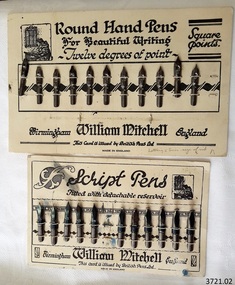
Pen Nibs, 1920's
The two cards of nibs are retail display cards of the dip pen nibs that William Mitchell Calligraphy produced, dating back to around the 1920’s, which was the time of the Great Exhibition in the UK. At that time dip pens with steel nibs were the main writing instruments. British Pens Ltd. had recently formed as a company and its subsidiaries included the the company William Mitchell, which is why British Pens Ltd. is named on the cards as well. One card (1) has the Round Hand nib, which is widely used today for calligraphy scripts. The other card (2) has the Script nib that has round upturned points for monocline or unshaded lettering that is also used for calligraphy. The nibs also have a detachable reservoir. The pen nibs are shaped to fit into a slot in the base of a wooden or Bakelite pen holder. The hole at the front of the nib is for collecting ink from a well, which is then stored in a reservoir at the back of the nib. The nibsare stamped with their nib size and Pedigree (what type of nib it is) and maker’s details. William Mitchell Calligraphy still makes these nibs today with a slightly difference finish. (ref: Sales and Marketing Director of William Mitchell Calligraphy in 2016). HISTORY of the Ink Pen Quills and ink were common writing tools until the early 19th century when the pen trade began mass producing steel nibs and pens. The steel nibs each have a hole in the middle that acts like a well for the ink. When the nib is dipped into the ink well the writer needs to ensure that it is dipped to only just past that well. India Ink was one of the most popular inks used with the nib pens, notable for its satin-like smooth flow. This ink is composed of a particularly fine carbon mixed with water; it can also be obtained as a dry stick that is then crushed and mixed with water as required. The Jewellery Quarter of Birmingham had the largest concentration of independent jewellers in Europe. Birmingham became the centre of the world’s pen trade for many years -, during the 1800’s over 100 factories, employing 1000s of skilled workers, manufactured the ‘Birmingham Pen’. ABOUT WILLIAM MITCHELL CALLIGRAPHY LTD.* (*The following text is quoted from the William Mitchell Calligraphy website) British based William Mitchell Calligraphy has been designing and manufacturing exceptional pens for almost 200 years. The William Mitchell heritage in making pen nibs began whilst working with his brother John Mitchell in the early 1820s. William Mitchell established his own business in 1825 to become one of the leading nib manufacturers and famous for lettering pens. Almost 100 years later William Mitchell merged with Hinks, Wells & Co, another pen manufacturer, to form British Pens, employing around 1000 people in the Bearwood Road area of Birmingham. During the early 1960s British Pens acquired the pen business of other pen manufacturers Perry & Co and John Mitchell, once again reuniting the two brothers. Joseph Gillott, who were famous for their artist drawing and mapping nibs, amalgamated with British pens in 1969. William Mitchell and Joseph Gillott established in Birmingham during the early part of the nineteenth century and [their products] are still proudly made here. British Pens were subsequently purchased by its current owner Byron Head, the owner of William Mitchell (Sinkers) in 1982, and was subsequently renamed William Mitchell (calligraphy) Ltd. Established in 1827 Joseph Gillott was one of the pioneers of mass steel pen nib manufacturing. The company was particularly strong in the American market, prompting Elihu Burrit, the American consul, to write “In ten thousand school houses across the American continent between two oceans, a million children are as familiarly acquainted with Joseph Gillott as with Noah Webster” (The compiler of the famous American dictionary). The company consequently received visits from many notable Americans, including president Ulysses S Grant. The early 19th century invention and mass production of pen nibs such these in our collection had a large impact on education and literacy because the nibs could be produced in great numbers and affordable prices.Pen nibs; 2 cards of steel dip pen nibs from the 1920’s. The steel nibs are attached to cards by 2 rows of entwined cotton cord. Reverse sides of cards have some hand written marks. Manufacturer; William Mitchell, Birmingham, England. Card issued by British Pens Ltd. Nibs have shaped ends, a hole in the centre with a well on the underside, and the tops are shaped approximately quarter circle. Inscriptions are pressed into each nib. The script pens have detachable reservoirs made of a metal different to the nib. (Card 1) Round Hand Pens, 11 nibs remain from card of 12. Printed on card “Round Hand Pens for Beautiful Writing, Twelve degrees of point, Square points. William Mitchell, Birmingham, England. This card is issued by British Pens Ltd. MADE IN ENGLAND” Also printed on top left of card is a pen drawing of a person writing at a desk, background of decorative 3-paned window in brick wall. (Card 2) Script Pens; 11 nibs remain from card of 12. “Script pens fitted with detachable reservoir. William Mitchell, Birmingham, England. This card is issued by British Pens Ltd. MADE IN ENGLAND” Also printed on top right of card is a pen drawing of a person writing at a desk, background of decorative 3-paned window in brick wall. On Card 1, - each nib is stamped with its size, and “Wm MITCHELLS / PEDIGREE / ROUND HAND / ENGLAND” - hand written on front bottom of card in ball point pen “Lettering 5 times size of nib” - hand drawn on back of card in red and blue ball point pen are scribbled lines On Card 2 - each nib is stamped with its size, and “WILLIAM / MITCHELLS / SCRIPT PEN / ENGLAND” - a black circle corresponding to the nib is printed on the card above each nib. - hand written on back of card in black felt tip pen are numerals - hand drawn on back, 4 parallel lines in red ball point pen with the numbers “10” between 2 of the lines flagstaff hill, warrnambool, shipwrecked coast, flagstaff hill maritime museum, maritime museum, shipwreck coast, great ocean road, william mitchell calligraphy ltd, british pens ltd., pen nib, writing implement, dip pen, round hand nib, script nib, birmingham manufacturer, communication in writing, mass produced pen nibs -
 Kew Historical Society Inc
Plan, Melbourne & Metropolitan Board of Works : Borough of Kew : Detail Plan No.1568, 1905
The Melbourne and Metropolitan Board of Works (MMBW) plans were produced from the 1890s to the 1950s. They were crucial to the design and development of Melbourne's sewerage and drainage system. The plans, at a scale of 40 feet to 1 inch (1:480), provide a detailed historical record of Melbourne streetscapes and environmental features. Each plan covers one or two street blocks (roughly six streets), showing details of buildings, including garden layouts and ownership boundaries, and features such as laneways, drains, bridges, parks, municipal boundaries and other prominent landmarks as they existed at the time each plan was produced. (Source: State Library of Victoria)This plan forms part of a large group of MMBW plans and maps that was donated to the Society by the Mr Poulter, City Engineer of the City of Kew in 1989. Within this collection, thirty-five hand-coloured plans, backed with linen, are of statewide significance as they include annotations that provide details of construction materials used in buildings in the first decade of the 20th century as well as additional information about land ownership and usage. The copies in the Public Record Office Victoria and the State Library of Victoria are monochrome versions which do not denote building materials so that the maps in this collection are invaluable and unique tools for researchers and heritage consultants. A number of the plans are not held in the collection of the State Library of Victoria so they have the additional attribute of rarity.Original survey plan, issued by the MMBW to a contractor with responsibility for constructing sewers in the area identified on the plan within the Borough of Kew. The plan was at some stage hand-coloured, possibly by the contractor, but more likely by officers working in the Engineering Department of the Borough and later Town, then City of Kew. The hand-coloured sections of buildings on the plan were used to denote masonry or brick constructions (pink), weatherboard constructions (yellow), and public buildings (grey). Plan No.1568 covers the area bounded by Cotham Road, John Street, Sackville Street, and Edward Street. Alfred Street and Rowland Street are in shown in the middle of the plan. The two most notable buildings shown are ‘St Helliers’, the home of the Dumaresq family, and St Hilary’s Church and school. While the colours used to indicate St Hilary’s are grey as in other civic/public buildings, the first St Hilary’s Anglican Church was at this stage constructed in weatherboard. At the left of the plan, facing Sackville Street is a house named ‘Glencara’. The 1988 ‘Kew Conservation Study’ recorded that “The first documentary evidence of this house comes from Rate Books which record that in 1893 a Mrs Treadway was the owner of this building with an N.A.V. of £81? At that date the occupier of the house was Charles B. Kelly, a clerk, while by 1910 Kelly had become the owner of the property described in that year ‘as a six-roomed stone, brick and wood house with stables and outbuildings’”. Contrary to this description, the 1905 plan indicates that the house was entirely constructed of masonry.melbourne and metropolitan board of works, detail plans, mmbw 1568 -
 Eltham District Historical Society Inc
Photograph - Digital Photograph, Alan King, St Margaret's Anglican Church, Pitt Street, Eltham, 30 January 2008
St Margaret’s Church of England was officially opened on December 12, 1861. It is the oldest intact church building in Eltham. At the time it was known as Christ Church until its consecration in 1871, when it was completely free of debt (£1,700 for the church and parsonage) despite the district’s poverty. This was largely due to the free labour and materials, including locally made bricks donated by local artisans and others. The church is historically significant because it is the oldest church in the former Shire of Eltham and has associations with the philanthropist and founder of Brighton, Henry Dendy (who donated the land on which the church is built), the architect Nathaniel Billing and the prominent local builder, George Stebbing. The church is architecturally and aesthetically significant because it is constructed in the Gothic Revival style with several stained-glass windows of various dates and is also a very early use of polychromatic brickwork in Victoria. Billing was one of the first Melbourne architects to employ polychromatic brickwork and an important early architect. The rear wall was intended to be temporary. A major feature of the design is the large buttresses with long, steeply graded upper faces. The overall design is well proportioned with the surface brick patterns relieving an otherwise austere design. The church is spiritually and socially significant because it has been an important place of worship for the people of Eltham for almost 150 years. The land on which the buildings stand was donated by Henry Dendy. Dendy arrived in Melbourne in 1841 after purchasing in England eight square miles at Brighton under the system of "special surveys". After this land passed out of his hands, Dendy moved about Victoria, visited England, then returned to settle in Eltham where he purchased a flour mill. Dendy chaired the meeting held in 1860 “for the purpose of devising such means as may be expedient for the establishment of a Church of England in the township of Eltham”. He became chairman and treasurer of the church committee. Unlike the establishment of many early churches in Victoria where a vicar was appointed to a parish and later a permanent church was constructed, the population at Eltham initiated action to build a church. The nearest church at that time was at Heidelberg and the Eltham settlement was part of the parish of St Johns Heidelberg. Isolation and the tedious, time consuming journey between Heidelberg and Eltham resulted in the Eltham community taking its own action. The original vicarage (Dendy House) at the rear of the church is also an important part of the cultural significance of this place because it is connected to the church and the development of the Eltham area. Together, the church and the vicarage are aesthetically significant because they form a significant streetscape feature. The mud-brick community hall designed by Robert Marshall was added in 1978. In 2014 the original temporary rear wall was removed as part of a modern extension designed by Architects Atelier Wagner and constructed by Conrad Construction and Management. Covered under Heritage Overlay, Nillumbik Planning Scheme. National Trust of Australia (Victoria) State significance Victorian Heritage Published: Nillumbik Now and Then / Marguerite Marshall 2008; photographs Alan King with Marguerite Marshall.; p67This collection of almost 130 photos about places and people within the Shire of Nillumbik, an urban and rural municipality in Melbourne's north, contributes to an understanding of the history of the Shire. Published in 2008 immediately prior to the Black Saturday bushfires of February 7, 2009, it documents sites that were impacted, and in some cases destroyed by the fires. It includes photographs taken especially for the publication, creating a unique time capsule representing the Shire in the early 21st century. It remains the most recent comprehenesive publication devoted to the Shire's history connecting local residents to the past. nillumbik now and then (marshall-king) collection, eltham, st margaret's anglican church, st margaret's church, christ church -
 Eltham District Historical Society Inc
Slide - Photograph, Eltham Courthouse, 730 Main Road, Eltham, c.May 1988
Built in 1860, the Eltham Courthouse is the oldest public building remaining in Eltham. In its early days the building was used as the meeting place and office of the Eltham District Road Board and as an overflow classroom for the local school. The Eltham Courthouse ceased operational duties in 1984 and is now used by various community groups including Eltham District Historical Society. It was listed on the Victorian Heritage Register (Number H0784) in 1982. The building is of architectural significance because it retains intact early features. These include use of handmade bricks, simple decoration, roof trusses, timber ceiling boards, original windows, doors and associated hardware and a collection of court furniture. Additions to the court house have been done in a manner which did not interfere with the fabric of the original building. It is a fundamental asset in the Eltham Justice Precinct and is being fully restored in 2021 thanks to Nillumbik Shire Council.35mm colour positive transparency (1 of 23) Mount - Kodak EktachromeProcess Date MAY 88Meltham, eltham courthouse, main road -
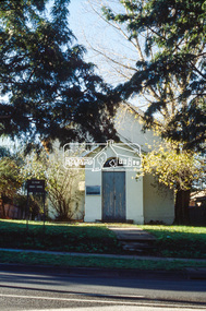
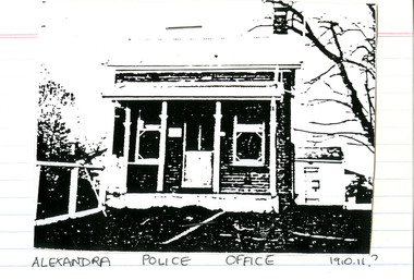 Victoria Police Museum
Police Stations (Alexandra)
Alexandra is a regional centre in the Shire of Murrindindi in Victoria, Australia and 130 kilometres north east of Melbourne. Alexandra Police Station opened in the Benalla Police District on 8 May 1867 in Bon Street, on the north side near Grant Street. When the station opened it was staffed by one Senior Constable; one 1st Constable (Mounted); one Foot Constable. The original building was a nine-roomed brick building with an iron roof on land measuring 84' x 97’. The house included a wash-house, pantry, bathroom, office, one W.C., stabling for three horses, a lock-up with two rooms and a single man's room. It closed in June 1977 and was replaced by a new police station which opened on 16 June 1977 in Bon Street, on land adjacent to the old police station. For a list of Officers in Charge 1871 to 1943 contact Victoria Police Museum1 black and white photo and 3 colour photospolice stations; alexandra police station -
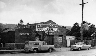 Eltham District Historical Society Inc
Photograph, Eltham Produce Store, ca 1960
Two vehicles including a Holden FC Special Sedan and ca 1958 Ford 100 truck are parked outside the Eltham Produce Store, Main Road, Eltham near Arthur Street. The brick building has signage to promote Tanox Paint and Permoglaze products. It also sold hay and grain. Operated by John McLean and Son. Situated just south from opposite Arthur Street, opposite the Eltham Village Shopping Centre. To the right was Garnet Burgess' second hand scrap metal and bottles, then the blacksmith shop, which was later taken over by Garnet with second hand furniture and next door to that was Ray Staff's grocery store. The store was demolished by 1963 for the BP Evergreen Service Station. See also: Cross Ref 00161 (print) and 01831-15 (negative duplicate) and SEPP_0785, See 00161, 01831-15, 01895-21This photo forms part of a collection of photographs gathered by the Shire of Eltham for their centenary project book, "Pioneers and Painters: 100 years of the Shire of Eltham" by Alan Marshall (1971). The collection of over 500 images is held in partnership between Eltham District Historical Society and Yarra Plenty Regional Library (Eltham Library) and is now formally known as 'The Shire of Eltham Pioneers Photograph Collection.' It is significant in being the first community sourced collection representing the places and people of the Shire's first one hundred years.Digital image. Copy of original photograph.sepp, shire of eltham pioneers photograph collection, eltham, eltham produce store, main road, tanox paint, permoglaze, holden fc special sedan, ford 100 truck -
 Federation University Historical Collection
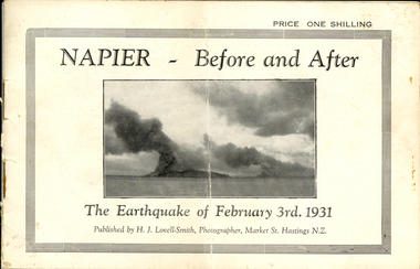
Booklet, Nelson Stedman, Napier Before and After the Earthquake of February 3rd 1931, c1931
The earthquake at Napier, also known as the Hawke's Bay Earthquake, took place on 03 February 1931 at about 10.45 am. There was no warning before the ground started to heave and roll in waves. It was not possible to stand without support, and the violent motion caused stone and brick buildings to collapse into the streets causing death and injury to hundreds who were going about there daily business. Fires started almost immediately, and with the water mains shattered, the fire fighters were powerless to stop or prevent the spread of the flames. Within twelve hours the greater part of the business area of Napier and its port was totally destroyed. As a result of the pressure which caused the upheaval, the levels of the town and the surrounding district have been altered. The town and the harbour were raised from five to seven feet, and many parts of the inner harbour became dry land. Small booklet of 18 pages with photographic comparisons of New Zealand's Napier region before and after the 1931 earthquake.napier, new zealand, earthquake, lovell-smith, stedman, boston, port ahururu, westshore, clive square, hawke's bay -
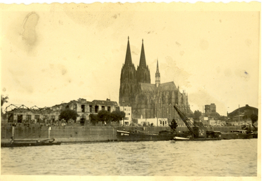 Federation University Historical Collection
Photograph - black and white, Cologne Cathedral from the Rhine, c1950
Cologne Cathedral is a renowned monument of German Catholicism and Gothic architecture and is a World Heritage Site. It is Germany's most visited landmark, attracting an average of 20,000 people a day. (Wikipedia) Though not targeted itself, the cathedral was very near to the central railway station and suffered fourteen hits by aerial bombs during World War II. Badly damaged, it nevertheless remained standing in an otherwise completely flattened city. The twin spires were an easily recognizable navigational landmark for Allied aircraft bombing deeper into Germany, which may explain why the cathedral was spared. Repairs were completed in 1956. An emergency repair on the northwest tower's base carried out in 1944 using poor-quality brick taken from a nearby ruined building remained visible until 2005 as a reminder of the war, when it was decided to restore the section its original appearance. (Wikipedia) Black and white photograph showing a grand cathedral from a waterway. It is Cologne (Koln) Cathedral from the Rhine. To the left of the photo bombed buildings are evident. The photograph is believed to have been taken by Frank Wright.cologne cathedral, koln, germany, rhine, bombing, world war two, frank wright -
 Nillumbik Shire Council
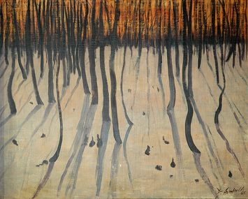
Painting: David ARMFIELD (b.1923 Melb AUS - d. 2010 Melb AUS), David Armfield, Panton Hill, c.1980
David Armfield studied at the National Gallery School in the 1940s and turned to full time painting in 1965. RMIT printamking. He has won several art awards, including the Ramsay Prize - NGV School, the Redcliffe and in 1980 the Eltham Prize. Armfield is represented in the National Gallery collection, Art Gallery of NSW, Tasmanian Art Gallery, several regional art galleries across Australia as well as private collections. David Armfield first came to Eltham in the late 1903s on painting trips and used to camp on the banks of the Diamond Creed. He returned to Eltham in 1957 with his wife Joan who has subsequently become one of the district's potters, and built a mud brick house and studio in John Street on land adjoining Peter Glass. He has painted many landscapes in the district including intimate studies of the bush floor and the aftermath of bush fires.Oil on canvas painting depicting a Panton Hill bush scape.Signed: D. Armfield in lower right hand corner. Not dated.david armfield, eltham art prize, panton hill -
 Nillumbik Shire Council
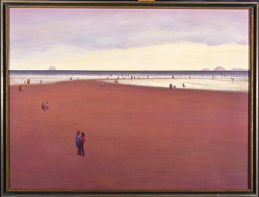
Painting: David ARMFIELD (b.1923 Melb AUS - d. 2010 Melb AUS), David Armfield, Untitled (Beach), c. 1975
David Armfield studied at the National Gallery School in the 1940s and turned to full time painting in 1965. RMIT printamking. He has won several art awards, including the Ramsay Prize - NGV School, the Redcliffe and in 1980 the Eltham Prize. Armfield is represented in the National Gallery collection, Art Gallery of NSW, Tasmanian Art Gallery, several regional art galleries across Australia as well as private collections. David Armfield first came to Eltham in the late 1903s on painting trips and used to camp on the banks of the Diamond Creed. He returned to Eltham in 1957 with his wife Joan who has subsequently become one of the district's potters, and built a mud brick house and studio in John Street on land adjoining Peter Glass. He has painted many landscapes in the district including intimate studies of the bush floor and the aftermath of bush fires.'Untitled' by David Armfield an oil on canvas painting depicts sand, sea, distant mountains and various figures scattered about in a typical Armfield landscape. The figures tend to be annonymous, sometimes included more to establish the scale than for a narrative purpose. The figures are well clothed and it could be assumed that it is not a hot summer's day. Depth is established by changing of colours and diminishing the size of the figures.david armfield, beach, eltham, nillumbik shire council -
 Nillumbik Shire Council
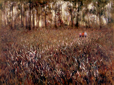
Painting: David ARMFIELD (b.1923 Melb AUS - d. 2010 Melb AUS), David Armfield, Eltham 1965, 195
David Armfield studied at the National Gallery School in the 1940s and turned to full time painting in 1965. RMIT printamking. He has won several art awards, including the Ramsay Prize - NGV School, the Redcliffe and in 1980 the Eltham Prize. Armfield is represented in the National Gallery collection, Art Gallery of NSW, Tasmanian Art Gallery, several regional art galleries across Australia as well as private collections. David Armfield first came to Eltham in the late 1903s on painting trips and used to camp on the banks of the Diamond Creed. He returned to Eltham in 1957 with his wife Joan who has subsequently become one of the district's potters, and built a mud brick house and studio in John Street on land adjoining Peter Glass. He has painted many landscapes in the district including intimate studies of the bush floor and the aftermath of bush fires. Painting: oil on canvas. Depicting the desolate aftermath of a bushfire in Eltham. Trees are bare and burnt, foreground is sparse, whilst background is fiery red.david armfield, eltham, bushfire -
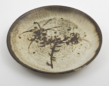 Nillumbik Shire Council
Ceramic (plate): Joan Armfield & David Armfield, David Armfield, Platter with dolomite glaze and Grevillia decoration, c.1975
David Armfield: David Armfield studied at the National Gallery School in the 1940s and turned to full time painting in 1965. RMIT printamking. He won several art awards, including the Ramsay Prize - NGV School, the Redcliffe and in 1980 the Eltham Prize. Armfield is represented in the National Gallery collection, Art Gallery of NSW, Tasmanian Art Gallery, several regional art galleries across Australia as well as private collections. David Armfield first came to Eltham in the late 1930s on painting trips and used to camp on the banks of Diamond Creed. He returned to Eltham in 1957 with his wife Joan who has subsequently become one of the district's potters, and built a mud brick house and studio in John Street on land adjoining Peter Glass. He has painted many landscapes in the district including intimate studies of the bush floor and the aftermath of bush fires.Ceramic stoneware. Reduction fired, dolomite glaze, wax resist decoration over iron. Decorated/painted by David Armfield. Cast by Joan Armfield. -
 Bayside Gallery - Bayside City Council Art & Heritage Collection
Work on paper - watercolour, John C. Paul, St. Andrew's Brighton, 1971
St Andrew’s Anglican Church, located at 228 New St, Brighton, is the oldest continuous Anglican Church in Victoria. Opened on St Andrews day in 1842, it was one of the earliest Christian churches established in the Port Phillip District. A second church building was erected on the site in 1851, followed by a third building and schoolhouse in 1857 which was enlarged in 1886. A fire in 1961 engulfed the building and renowned Australian church architect Louis Williams was appointed to be the architect of the new building. The present church complex is amongst the largest church buildings in Australasia. Using over 500,000 bricks and over 16,000 roof tiles, this space consisted of three areas: the main church building, the Pioneer chapel and the Lady chapel. The large arcaded cloister, seen in this painting, with an internal cloister garden, is extremely rare in any church in Australasia, and links the Pioneer Chapel to the narthex of the new building.John C. Paul, St. Andrew's Brighton 1971, watercolour, 44 x 30.5 cm. Bayside City Council Art and Heritage Collection. Purchased 1974.brighton, john c paul, st andrews, church, anglican, cloister, arcade -
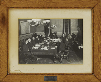 Kew Historical Society Inc
Photograph - Framed Photograph, Kew Town Council, circa 1903, c. 1904
Medical practitioner Sir Stanley Seymour Argyle (1867-1940) was a man ‘much admired’ for his civic contribution to Kew. To ensure ‘pure [uncontaminated]’ milk for Kew, he co-foundered the Willsmere Certified Milk Company in 1898. His mayoralty of Kew, 1902-04, exhibited superior leadership. In association with local chartable institutions and churches he ensured the unemployed of Kew were not distressed. He also agitated for the removal of the Kew Lunatic Asylum. After a long stint as a doctor in the Army Medical Corps with the Australian Expeditionary Force, Kew formally welcomed him back home in 1918. However, in 1919 he left his two-storey red brick home, on the ‘corner of Gellibrand Street’ for Toorak. He went on to have an outstanding career in radiology at the Alfred Hospital and in Victorian politics. He was cremated following a State funeral. (SMcW)An important photograph of local and statewide historical significance showing Sir Stanley Argyle, Mayor of Kew. Argyle was later to be Premier of Victoria. This is a commemorative photograph, presented by Argyle to the Town of Kew.An early, important photograph of the Kew Councillors at a meeting in the Council Chamber of the Kew Town Hall in Walpole Street. The framed photograph was donated by Sir Stanley Seymour Argyle (1867-1940) who was Mayor of Kew in 1902-03 and 1903-04. Stanley Argyle, later to be Premier of Victoria, is in the mayoral chair wearing his robes of office. The photograph was once displayed in the Kew Town Hall. Brass Plaque: "Presented by / Cr Stanley S. Argyle / Mayor 1902-3 & 1903-4".sir stanley argyle (1867-1940), kew town council, council chamber (kew town hall) -
 Vision Australia
Text, AFB Loddon Mallee Regional Committee minutes: 8/7/1996 - 11/3/1997, 1996-1997
Held at the 'Mirridong' Home for the Blind, McIvor Rd, Bendigo, these minutes contain information on attendees, meeting chair, apologies, confirmation of minutes, reports including from Auxiliaries and the Building, house and grounds, matters arising from reports, recommendations, Life Governors awards, general business and the date of the next meeting. It was noted that a fundraising campaign had been established to raise $100,000 from the Mildura District community for a Radio station for the Print Handicapped at Mildura. The "Paving the Way" program which was designed to help build the National Information Centre at Kooyong had been launched. For a gift of $100, individuals, businesses and organisations may have their names permanently inscribed on the brick pavers used to create the area. The Centenary Appeal was in action to raise $750,000 to enable commencement of the re-development of the Mirridong Home for the Blind - Amy Bayne Wing. 1 volumemirridong home (bendigo), association for the blind -
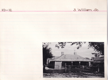 The Beechworth Burke Museum Research Collection
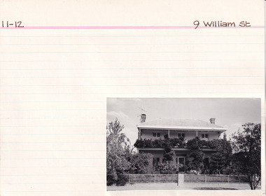
Card (Series) - Index Card, George Tibbits, 3 William Street, Beechworth, 1976
George Tibbits, University of Melbourne. Faculty of Architecture, Building and Town & Regional PlanningIndex system that support the research for Beechworth : historical reconstruction / [by] George Tibbits ... [et al]Arranged by street names of BeechworthEach index card includes: street name and number of property, image of property, allotment and section number, property owners and dates of ownership, description of the property according to rate records, property floor plan with dimensions.beechworth, george tibbitsbeechworth, george tibbits -
 The Beechworth Burke Museum Research Collection
Card (Series) - Index Card, George Tibbits, 9 William Street, Beechworth, 1976
George Tibbits, University of Melbourne. Faculty of Architecture, Building and Town & Regional PlanningIndex system that support the research for Beechworth : historical reconstruction / [by] George Tibbits ... [et al]Arranged by street names of BeechworthEach index card includes: street name and number of property, image of property, allotment and section number, property owners and dates of ownership, description of the property according to rate records, property floor plan with dimensions.beechworth, george tibbitsbeechworth, george tibbits -
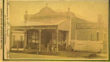 Bacchus Marsh & District Historical Society
Photograph, Pearce Brothers Store Main Street Bacchus Marsh 1883
This store was built in 1881 and opened as a branch of Pearce Brothers main store which was further along in Main Street, Bacchus Marsh. The store in this image opened around early June 1881 and was described in the Bacchus Marsh Express as "quite above the usual standard of stores in towns of a similar or even much larger size. The building is most substantially built of brick, and measures 58 feet by 26 feet, with walls fourteen feet high inside. The interior is most elaborately fitted with shelves and glass cases covering both side walls and two ends formed by small offices separated from the main store by glass and wood panelled partitions, with a passage way between to the storeroom at the rear", Express, (Bacchus Marsh, 11 June, 1881, page 2). The building was designed by one of its proprietors T. G. Pearce and was entirely constructed by local contractors and workers.Small sepia unframed photograph on card with gold border framing photograph. Housed in the album, 'Photographs of Bacchus Marsh and District in 1883 by Stevenson and McNicoll'. The image depicts a general store with a double-front of windows. Goods such as spades, shovels, tubs and wringers are arrayed on the footpath in front of the store. At the front of the shop under a verandah stands a man, possibly one of the Pearce brothers who owned this business. Next to the store is a vacant block of land with a white picket fence. A sign erected above the fence advertises: “ Pearce Bros. Chaff. Hay & Oats. Produce. Dealer. “On the front: Stevenson & McNicoll. Photo. 108 Elizabeth St. Melbourne. COPIES CAN BE OBTAINED AT ANY TIME. On the back: LIGHT & TRUTH inscribed on a banner surmounted by a representation of the rising sun. Copies of this Portrait can be had at any time by sending the Name and Post Office Money Order or Stamps for the amount of order to STEVENSON & McNICOLL LATE BENSON & STEVENSON, Photographers. 108 Elizabeth Street, MELBOURNE. pearce family bacchus marsh, general stores bacchus marsh, shops bacchus marsh, pearce brothers general store bacchus marsh, stevenson and mcnicoll 1883 photographs of bacchus marsh and district -
 Bendigo Historical Society Inc.
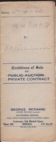
Document - H.A. & S.R. WILKINSON COLLECTION: CONDITION OF SALE
Conditions of sale by private contract issued by George Pethard dated 15th April, 1924, between George Pethard acting on behalf of The Manchester Unity Independent Order of Oddfellows Bendigo District Widows and Orphans Fund as Mortgagees and Henry Archibald Wilkinson (buyer), land situate at no. 121 Mundy Street Bendigo at present occupied by Mr. Spencer as tenant. Crown allotment 10 of section 8c Parish of Sandhurst city and county of Bendigo described in certificate of title volume 2732 folio 546267 having a frontage of 125 links by a depth of 200 links. Together with six-roomed brick house and all sundry. Price 500 pounds.organization, business, h.a. & s.r wilkinson real estate -
 Bendigo Historical Society Inc.
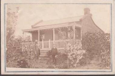
Photograph - HOUSE
Small photograph of a house with a man and a boy standing in the garden. The house is an Early Victorian style. House is made of bricks with sides extending higher than the roof which is iron. The front door is centre front and windows placed centrally between the door and the side walls. The veranda has six poles to hold it up and iron lace. The veranda, which has five steps up to it, has a fence at the edge and a gate. The garden has a number of bushes and shrubs. The boy is wearing a suit and is holding a hat in his hand. The man is wearing a suit with a longish jacket. The photo is mounted on white card with a blue border. Written on the back is: 492 x 6 Hall.buildings, house, homes, house, hall -
 Bendigo Historical Society Inc.
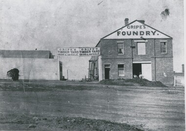
Photograph - GRIPES FOUNDRY, 1861
black and white photo: 2 storey brick building on right. Large central double door ground floor. Door in first storey with beam for raising materials. 2 windows first storey, one on each side of door. Small door and small window on lhs ground floor. Gripes Foundry on gable steps on side to top storey. Entrance gate centre of photo. Double inscription ' Gripes Timber Yard Iron & on sale over gate. Single storey building on left. 2 males in front. Batchelder cart left hand side. In image ' Gripes Foundry' 'Gripes Timber yard, iron & c on sale'batchelderorganization, business, gripes foundry -
 Bendigo Historical Society Inc.
Painting - OIL PAINTING BY HARRY CLARKE
Original oil painting, by Harry Clarke of mud brick house & outbuildings near Eaglehawk Golf Course, in a timber frame, signature bottom right corner, with note stuck on rear. Harry Clark lived in Lobb St North Bendigo with his wife and son Max in 1940s. He moved around working for thre mines including Central Deborah (managing or as an inspector). he lived in Alice Springs for a while. He shifted to Wangaratta where he died aged in his 80s. H eloved painting buildings and old houses and landscapes in Central and Goldmines Districts. Information from note attached to painting. Note not signed.Harry Clarkeartwork, oil painting, landscape, victoria-history-eaglehawk