Showing 8509 items
matching snowy-river-dry-cleaners
-
 Glen Eira Historical Society
Article - Toyne, Gilbert
This file contains two documents. Typewritten letter from Peter Cuffley providing background on Gilbert Toyne, manufacturer of the QUICK-DRY Rotary Clothes Hoist in Dandenong Road. Envelope attached. Computer print-out on HUNG OUT TO DRY the book, written by Peter Cuffley. Interview with him on ABC Ballarat Radio. Small black and white photo of hoist.toyne gilbert, quick dry rotary clothes hoist, toyne trading co., farrier, vernegie, ellimatta road, morton road, caulfield racecourse -
 Lakes Entrance Historical Society
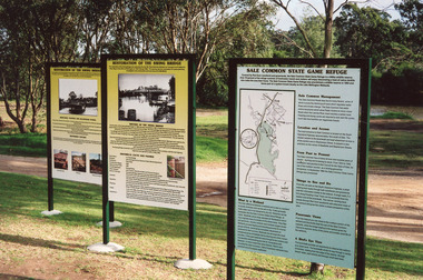
Photograph - Bridges, 2003
Also thirteen other photographs showing bridge open and closed.Colour photograph showing information boards giving the history of the iconic bridge and its relationship to the Gippsland Lakes historic swing bridge over the Latrobe River. The South Gippsland Highway no longer uses the swing bridge since two new bridges have been built a little upstream on the Latrobe River. Longford Victoria.bridges, waterways, local history, display -
![Scene near Corranderrk Station / [by] Nicholas Caire, circa 1876](/media/collectors/550653872162f11fb04854aa/items/57774ae0d0cdd10a5c12f2d7/item-media/57774b61d0cdd10a5c132dac/item-fit-380x285.jpg) Kew Historical Society Inc
Kew Historical Society IncPhotograph, Anglo-Australasian Photographic Company, Scene near Corranderrk Station, c. 1876
Nicholas Caire was born on Guernsey in the Channel Islands in 1837. He arrived in Adelaide with his parents in about 1860. In 1867, following photographic journeys in Gippsland, he opened a studio in Adelaide. From 1870 to 1876 he lived and worked in Talbot in Central Victoria. In 1876 he purchased T. F. Chuck's studios in the Royal Arcade Melbourne. In 1885, following the introduction of dry plate photography, he began a series of landscape series, which were commercially successful. As a photographer, he travelled extensively through Victoria, photographing places few of his contemporaries had previously seen. He died in 1918. Reference: Jack Cato, 'Caire, Nicholas John (1837–1918)', Australian Dictionary of Biography. The 1860s marked the beginning of the era of reserves and missions. Six Aboriginal reserves were established during the 1860s. These were under the control of the Board for the Protection of Aborigines. Four were Christian missions receiving government aid. These were Lake Tyers (Anglican) and Ramahyuck (Presbyterian/Moravian) in eastern Victoria for the Gunai/Kurnai clans; Ebenezer (Moravian) in north-west Victoria for the clans of the Wimmera and Lower Murray; and Lake Condah (Anglican) in south-west Victoria. The other two were secular government controlled reserves: Framlingham which, like Lake Condah, was established for the Mara-speaking Gunditjmara and Kirrae-wurrung people of south-west Victoria; and Coranderrk, located about 60 kilometres north-east of Melbourne, for the Kulin clans of central Victoria. In 1863, after a period of devastation to the Kulin people, Coranderrk was established at the junction of the Yarra River and Badger Creek. Reference: http://coranderrk.com/, accessed 24 December 2016An original, rare photograph from the series 'Views of Victoria: General Series' by the photographer, Nicholas Caire (1837-1918). The series of 60 photographs that comprise the series was issued c. 1876 and reinforced a neo-Romantic view of the Australian landscape to which a growing nationalist movement would respond. Nicholas Caire was active as a photographer in Australia from 1858 until his death in 1918. His vision of the Australian bush and pioneer life had a counterpart in the works of Henry Lawson and other nationalist poets, authors and painters.Albumen silver photograph mounted on boardprinted in ink on support l.c.: SCENE NEAR "CORRANDERRK" STATION. / COPYRIGHT REGISTERED. printed in ink on support reverse c.: VIEWS OF VICTORIA. / (GENERAL SERIES.) / No. 9. / SCENE NEAR "CORRANDERRK" STATION. / This scene was taken from the hill near Rourke's Bridge, on the Healesville Road, and displays in the foreground / the River Yarra. The roadway which is seen in the mid-distance has lately been constructed by the Government, / as the old tracks which formerly existed, were liable to be swamped by the periodical overflowing of the River. Mount / Ridell can be seen in the extreme distance immediately behind the roadway. / Corranderrk is the local habitation / for the natives of this district, and is situated on the right hand side of the picture, about a mile and a half / from the roadway. printed in ink on support reverse l.c.l.: J.W. FORBES, Agent, printed in ink on support reverse l.c.: ANGLO-AUSTRALASIAN PHOTOGRAPHIC COMPANY, MELBOURNE. printed in ink on support reverse l.c.r.: 10 Temple Court, Collins Street West.nicholas caire (1837-1918), coranderrk aboriginal station, aborigine, yarra river, badger creek, first peoples, aboriginal and torres straight islander -
 Broadmeadows Historical Society & Museum
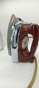
Domestic object - Steam Iron
Hoover Steam or Dry Iron - vintage 1950s or 1960s. It is a compact and heavy iron with electric cable. Model 4554This is an early electric stem iron, with a cloth covered power cable.Old Hoover iron with different settingsThe Hoover Iron trademark, model 4554, Ser No RF71510, 240V. 1000 watts A.C. only. Made at Meadowbank, Sydney, NSW, Hoover (Australia) Pty Limitediron, steam iron, electric, hoover brand -
 Port of Echuca
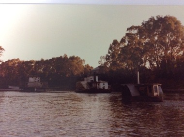
Colour negative, coloured photograph and coloured enlargement, 03/04/1984
These photographs and negative show the P. S. Adelaide travelling from Paddlewheel Park up to the Echcua wharf, immediately after being re-launched into the Murray River on 03/04/1984. The P.S.Adelaide had been displayed in the Hopwood Gardens, as a static display since 1960. The P.S Adelaide is the second oldest wooden hulled paddle steamer, still operative, in the world. The P.S Pevensey is leading the way up to the wharf, and an unknown smaller paddle steamer follows behind. This photograph is significant because it shows the P.S Adelaide back in the Murray River after 24 years as a static display in the Hopwood Gardens. The P.S Adelaide is the second oldest wooden hulled paddle steamer, still operative in the world. In July 2016 it celebrated its 150th birthday. These images relate to P000059.3, P000060.3, P000061.3, P000062.2, P000063.3, P000070.2, P000071.Colour negative and two different sized photographs showing three paddle steamers travelling upstream towards the Echcua Wharf. There is a small unidentifiable paddle steamer in the foreground. The P.S Adelaide is sailing between the other two paddle steamers. The P.S Pevensey is in the background. The P.S Murray Queen is in the foreground. All three boats are heading towards the wharf, immediately after the re-launch of the P.S Adelaide from the Hopwood Gardens, back into the Murray River on 03/04/1984.p.s pevensey, p.s adelaide, p.s philadelphia, echcua wharf, p.s murray queen -
 Orbost & District Historical Society
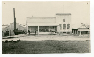
black and white photograph, 1917
This photograph shows the Orbost Butter factory, which in 1917, installed a very successful electric light. the dark heap to the left of the road is Supposedly the grave of "Dan the Cook" who was speared by Aborigines in 1857. Dan Moylan, known as "Dan the Cook"was speared to death in 1851 at Orbost Station, Snowy River as punishment for kidnapping a young Aboriginal girl and holding her for three days, refusing to release her. The men of the tribe congregated at Dan's hut. When Dan came outside, a volley of spears was launched at him, killing him. In the tragic aftermath, the camp at Milly Creek was attacked in retribution and a number of Gunai/Kurnai people were killed. The Orbost Butter and Produce Co. Ltd was registered on June 1st 1893 and was an important source of income to the Orbost district. These photos are pictorial records of the Orbsot Butter Factory.A black / white photograph showing a large white building and factory beside it. on the verandah are about thirty milk churns. There are three men standing astride bicycles in front of the verandah. On the left hand side is a mound of dark soil?? -
 Kiewa Valley Historical Society
Set of 4 photographs of SECV Clerical staff, 1940 - 1941
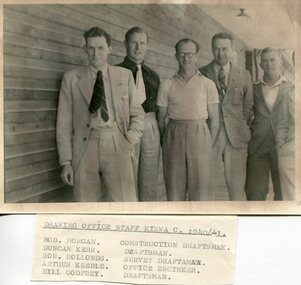
The Kiewa Hydroelectric Scheme is the largest hydro-electric scheme in Victoria and the second largest in mainland Australia after the Snowy Mountains Scheme. The scheme is situated in the Australian Alps in north-eastern Victoria about 350 km from Melbourne and is wholly owned by AGL Energy. The scheme was originally constructed between 1938 and 1961 by the State Electricity Commission of Victoria although it was privatised in the 1990s. The scheme was originally developed solely for electricity generation, unlike the Snowy Mountains Scheme, which was also intended to direct water west of the Snowy Mountains for purposes of irrigation. From 1937 to 1944 the construction of dams at Pretty Valley, Rocky Valley and the Junction Dam were undertaken requiring large numbers of planning and support staff to see the projects successfully completed. Planning and support staff were the backbone of the successful completion of the Kiewa Valley Hydro Electric Scheme and contributed significantly to the development of the Kiewa Valley area. Many descendants of the men in the photographs still living and working in the local areaSet of 4 black and white photographs of SECV clerical staff – Circa 1940/1941Typed on note glued to back of each photo, Numbers handwritten in blue ink in top left hand corner 1. DRAWING OFFICE STAFF KIEWA C. 1940-41 Bob Morgan – Construction Draftsman; Duncan Kerr – Draftsman; Rob Hollands – Survey Draftsman; Arthur Keeble – Office Engineer; Bill Godfrey – Draftsman 2. CLERICAL OFFICE STAFF KIEWA Peter Harnetty – Clerical; Bert Connors – Clerical; John Martin – Stores Clerical; Ken Calder – Head Storekeeper; Bill black – Construction Records 3. CLERICAL OFFICE STAFF KIEWA Jack Norman, Herb Kendall, Jack Bray – Stores Clerical; Ken Calder – Head Storekeeper; Jim Swain, George Milner – Stores Clerical; Jim Gleeson – Storekeeper; John Martin – Stores Clerical 4. OFFICE STAFF KIEWA C. 1940 Don Faulkner – Cadet Engineer; Tas Davies – Survey Draftsman; Bob Morgan – Construction Darftsman; R.J. Martin, Arthur Keeble – Office Engineers; Rob Hollands – Survey Draftsman; Jack Wollard – Head Surveyor; Harry Wilson – Plan Officer. Printing Plans Handwritten in red ink on back of photo 4 – Refer Rob Hollands secv clerical staff -
 Kiewa Valley Historical Society
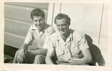
Photograph of Ray Esdaile and unidentified man, 1950
The Kiewa Hydroelectric Scheme is the largest hydro-electric scheme in Victoria and the second largest in mainland Australia after the Snowy Mountains Scheme. The scheme is situated in the Australian Alps in north-eastern Victoria about 350 km from Melbourne and is wholly owned by AGL Energy. The scheme was originally constructed between 1938 and 1961 by the State Electricity Commission of Victoria although it was privatised in the 1990s. The scheme was originally developed solely for electricity generation, unlike the Snowy Mountains Scheme, which was also intended to direct water west of the Snowy Mountains for purposes of irrigation. From 1937 to 1944 the construction of dams at Pretty Valley, Rocky Valley and the Junction Dam were undertaken requiring large numbers of planning and support staff to see the projects successfully completed. Planning and support staff were the backbone of the successful completion of the Kiewa Valley Hydro Electric Scheme and contributed significantly to the development of the Kiewa Valley area. Many descendants of the original SECV workers are still living and working in the local areaBlack and white photograph of 2 men, one identified as Ray Esdaile at Mt Beauty SEC Camp in 1950Handwritten on back of photograph in blue ink: Ray Esdaile and self (unidentified) 1950 Mt Beauty Camp SECray esdaile, secv, mt beauty -
 Bendigo Military Museum
Memorabilia - PHOTOGRAPHS, 5) 1942
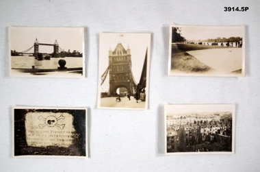
Photos taken by Frederick Gardner DAVEY whilst in UK, c.1942 Item re Frederick Gardner DAVEY DFC No 410533 RAAF. Refer Reg No 3536P for his service details.Series of 5 black / white photos depicting scenes of London & Brighton. .1) Tower Bridge with River Thames in foreground. .2) One of the Tower Bridge towers. People & vehicles crossing the bridge. .3) People sitting on the edge of the Serpentine River, Hyde Park. .4) Plaque. .5) View of a row of terrace houses in Brighton.Handwritten in black ink of back of each: .1) London Bridge .2) Tower Bridge, London .3) Serpentine, Hyde Park, London .4) Plaque in Tower of London .5) Roof top view of Brighton. End. 1942photography, london, wartime -
Federation University Historical Collection
Map, Otways Walks and Waterfalls Map, 2013, 06/2013
Tourist map of the Otways showing the townships of Colac, Lorne, Apollo Bay, Beech Forest, Forrest, Barwon Downs, Deans March, Winchelsea, Gellibrand, Lavers Hill, POrt Campbel, Princetown, Johanna, Timboon, Cobden, Camperdown, Swan Marsh, Simpson, Birregurra, Beeac, Marengo, Wye River, Kennett River, Skenes Creek, Peterboroughcolac, lorne, apollo bay, beech forest, forrest, barwon downs, deans march, winchelsea, gellibrand, lavers hill, port campbel, princetown, johanna, timboon, cobden, camperdown, swan marsh, simpson, birregurra, beeac, marengo, wye river, kennett river, skenes creek, peterborough< marriners falls, beauchamp falls, hopetoun falls, triplet falls, little aire falls, stevensons falls -
 Bendigo Historical Society Inc.
Map - FRED COWIE COLLECTION: AERIAL MAPS OF HEATHCOTE/EPPALOCK, 28-9-60
Map, Heathcote C3, Aerial Survey of Victoria, Photo-map prepared by Department of Crown Lands and Survey from photographs taken in 1960.Copied photographically at the Central Plan Office. Date 28-9 60, C.P.O.Neg. No.21588.Campaspe River, Coliban River. Flower Hill. Fred Cowie,46 McIvor Rd.Bendigo (Not located 29.9.2022)Central Plan Office.map, heathcote, fred cowie -
 Kew Historical Society Inc
Photograph - Victorian Canoe Club, V.C.C. site, Studley Park, 1920-30
Canoeing on the River Yarra at Melbourne was an important and widespread recreational pursuit for Melbournians, especially in the first half of the twentieth century. The Victorian Canoe Club was formed in 1912 at a meeting in Melbourne and its first committee elected in the same year. Records indicate that the Club continued into at least the 1950s .The album has historic and social significance as a record of recreational activities (as well as canoe making) in the early years of the twentieth century. It has local significance as the site of the headquarters of the Club was in Studley Park. A number of photographs in the album provide vistas of Kew on the Yarra that are otherwise unavailable.One of 24 labelled photos in part album, originating from the Victorian Canoe Club, which had its headquarters in Studley Park, Kew. The album includes a photographic record of canoe construction and also locations in Studley Park and Kew where the canoes were used. The subject of this photograph is identified as 'V.C.C. site, Studley Park'.The panoramic view shows a number of important landmarks during this period. On the left of the photograph is one of the remaining buildings of the Yarra Bend Asylum. Stretching across the river is a suspension bridge on the site of the present Kane's Bridge. The reference to the V.C.C. site is unclear within the context of the photo which appears to be taken from the vicinity of the Johnston Street Bridge."V.C.C. site, Studley Park"victorian canoe club, river yarra, canoe clubs, yarra bend asylum, suspension bridge -- kew, kane's bridge, studley park -
Glenelg Shire Council Cultural Collection
Postcard - Postcard - Casterton, Victoria, c. 1946
SOURCED FROM CASTERTON TOWN HALL (FORMER SHIRE OF GLENELG)Black and white photo postcard. Casterton 1946 flood. Man in overalls in foreground behind barbed wire fence, several 44 gallon drums. Buildings on left, tractor towing horse float, whole area flooded, no dry land visible.Back: Purple stamp 'POSTCARD' Purple photographer's stampcasterton, flood, 1946, tourism -
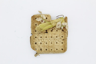 Warrnambool RSL Sub Branch
Ornamental biscuit, Phoenix Co, 1914-1918
This biscuit is called a 'Dog Biscuit' and was produced during WWI. It was part of a rashion kit to accompany another biscuit and a tin of Bully beef. The original owner was presumably a serviceman called Jack was and he created a souvenir for a loved one using this biscuit, accompanied by another biscuit with an inlaid photograph of himself. This object is a rare and precious piece. It is rare for items composed of edible goods to remain almost perfectly intact after a century after creation. The use of the biscuit as a souvenir, with the addition of a artificial flowers, is presumably unique and imparts great social significance to the item.Dry biscuit with artificial flower decoration. The flowers are of light green and cream coloured fabric, wire and are attached in the top right hand corner of the biscuit. There are fabric strips attached to the back and tied with cotton string through holes in the lower right corner.Inscriptions on the front read: "Phoenix Co. Melbourne" biscuit, dog biscuit, military rations, ww1, world war 1, world war one, the first world war, the great war -
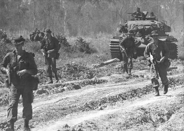 National Vietnam Veterans Museum (NVVM)
Photograph, Gibbons, Denis, Operation Goodwood
Denis Gibbons (1937 – 2011) Trained with the Australian Army, before travelling to Vietnam in January 1966, Denis stayed with the 1st Australian Task Force in Nui Dat working as a photographer. For almost five years Gibbons toured with nine Australian infantry battalions, posting compelling war images from within many combat zones before being flown out in late November 1970 after sustaining injuries. The images held within the National Vietnam Veterans Museum make up the Gibbons Collection. A black and white photograph of Diggers of 1st Battalion, Royal Australian Regiment, conducting Operation Goodwood move out with Centurian tank support from 1st Armoured Regiment, during this, the dry season. Operations with the tanks was a hot and very dusty affair.photograph, 1 rar, 1st armoured regiment, operation goodwood, centurion tank, gibbons collection catalogue, 1st battalion, diggers, denis gibbons -
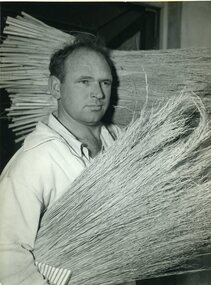 Vision Australia
Photograph - Image, QIIB workers and millet brooms
Three Queensland Industrial Institute for the Blind workers holding raw millet (name unknown), millet brooms (possibly Snowy Willis) and working a loom (Manix O'Reagan).3 x B/W photographs of people with millet or weavingE18302-2622 F26922-1564 E18300-2622queensland industrial institute for the blind, manix o'reagan, snowy willis, employment -
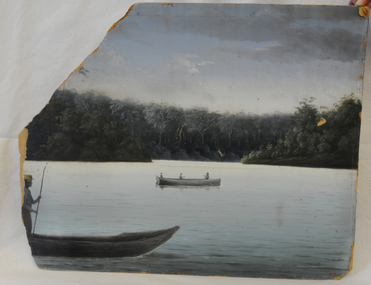 Orbost & District Historical Society
oil painting, 1889
Unframed oil painting on thick cardboard. Painting is of three men in a rowing boat on a river in background and close up of one man in boat.painting lake-tyers illustrations-oil -
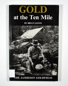 Marysville & District Historical Society
Book, Gold at the Ten Mile-The Jamieson Goldfield, 1995
A history of the Jamieson gold fieldPaperback. Black cover. Front cover has a photograph of a man gold panning with his dog in a river. In the background is an old wooden house.To the memory of my great grandfather Tom Allen,/ my grandfather Jim, Wray, my father Ben Lloyd and/ his uncle, Charlie Lloyd - all seekers of gold at the/ Ten Mile. Stamp of the Marysville & District Historical Society Inc / P.O. Box 22 / Marysville 3779 Stamp of the Marysville & District / Historical Society Inc.gold mines, gold mining, victoria, jamieson district, australia, history -
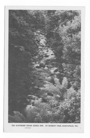 Marysville & District Historical Society
Postcard (item) - Black and white postcard, Rose Stereograph Company, At Murray Pass, Marysville, Vic, 1913-1967
A postcard in a series produced by the Rose Stereograph Company in Victoria, Australia as a souvenir of Marysville.An early black and white photograph of the Taggerty River from Murray Pass near Marysville, Victoria. Murray Pass is located on the Lady Talbot Drive. Lady Talbot Drive a 24 kilometer scenic rainforest car journey which passes a number of walks and waterfalls in the Yarra Ranges National Park. Lady Talbot Drive is named after Lady Sarah Elizabeth, the wife of Sir Reginald Talbot, who was the Governor of Victoria from 25th April, 1904 to 6th July 1908. This postcard was produced by the Rose Stereograph Company as a souvenir of Marysville.POST CARD. Correspondence Addressmarysville, victoria, photograph, taggerty river, murray pass, lady talbot forest drive, southern cross series, 2309, postcard, souvenir, lady talbot drive, sir reginald talbot, sarah elizabeth talbot -
 Bendigo Military Museum
Card - XMAS CARD, C.1969 - 71
Hand written inside. "Murray, I will never forget you, how are you? I hope you are always well! My regards to your mother. I hope to one day see you again in V.Nam. Sister Augustine". The card relates to Geoff Murray No 3411521, 3 Cav Regt Vietnam 27.11.67 to 22.10.68, Survey Corp Vietnam 15.10.69 to 15.10.70. On his 2nd tour with Survey Corp Geoff procured a lot of food etc for the Baria Orphanage. Refer 610.2P, 611.8, 1866.3 re the Orphanage and Sister Augustine also 638P.Christmas card with river scene painted on front. .1) Heavy card outer pages. .2) Fine tissue paper inner pages..1) "Greetings" .2) "Merry Christmas and Best Wishes for a Happy New Year"cards, xmas, vietnam -
Lorne Historical Society
Souvenir - Souvenir China Jug
Cream China ,handled milk jug with coloured transfer of Lorne overlooking the mouth of the Erskine River on one side.Gold leaf around the mouth.jugs, souvenirs -
Glenelg Shire Council Cultural Collection
Document - Document - A Trip to Donovan's, 1930s
Two page description of a road trip to Nelson and river cruise to Donovan's; part 2 of two contributions to a newspaper Observer, writer unknown -
Glenelg Shire Council Cultural Collection
Negative - Glass Plate Negative - Picnic scene, c. 1890
Glass plate negative. Image sgows a group of 2 men and 4 women, sitting on rugs 'picnicking' on banks of a river. Buggy in background. -
 Greensborough Historical Society
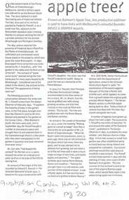
Article, Batman Apple Tree, 11/12/2002
Details some versions of the history of the 'Batman Apple Tree'. Also the condition and lack of maintenance of the tree in 2002. Highlights Nillumbik Shire's ignorance of the existence of the tree; which is within one kilometre of the Nillumbik Shire Offices.It is possibly the oldest European planted tree in Victoria. It was planted as a young tree in 1841.A4 photocopies of 3 articles relating to the condition and origin of the "Batman Apple Tree", located on the eastern bank of the Plenty River, north of Greensborough.Blue pen annotations on one article.apples, john batman, robert whatmough, frederick nevin flintoff, plenty river, 1841, rome beauty, rymer apples, winter majetin, apollo parkways primary school -
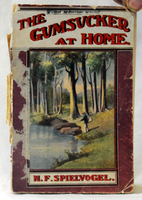 Orbost & District Historical Society
book, George Robertson & Co, The Gumsucker At Home, 1914?
Nathan Frederick Spielvogel (1874-1956), teacher, writer and historian, was born on 10 May 1874 at Ballarat, Victoria. as well as his stories he published a number of Books about the history of Ballarat. Spielvogel taught at Orbost for at least a year and this book reflects that time. Spielvogel was a teacher, writer and historian. As a country schoolteacher, he traveled widely in the eastern Australian outback and also made a journey to London. Spielvogel gained distinction as one of the only Australian Jewish writers of his time. Many of his early books were best-sellers. He has an association with the history of Orbost having spent a year as a teacher at Orbost. The book also has an association with J.W. Bird an early auctioneer and estate agent in Orbost.A small 124 pp book with a pink, white and red cover with an illustration of a fisherman at a river. It is titled "The Gumsucker at Home" by N. F. Spielvogel.inside cover - J. W. Birdspielvogel-nathan the-gumsucker-at-home australian-literature -
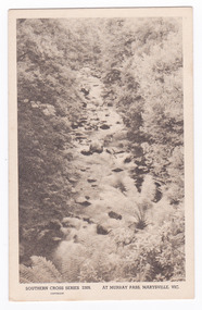 Marysville & District Historical Society
Postcard (item) - Black and white postcard, Rose Stereograph Company, At Murray Pass, Marysville, 1913-1967
A postcard in a series produced by the Rose Stereograph Company in Victoria, Australia as a souvenir of Marysville.An early black and white photograph of the Taggerty River from Murray Pass near Marysville, Victoria. Murray Pass is located on the Lady Talbot Drive. Lady Talbot Drive a 24 kilometer scenic rainforest car journey which passes a number of walks and waterfalls in the Yarra Ranges National Park. Lady Talbot Drive is named after Lady Sarah Elizabeth, the wife of Sir Reginald Talbot, who was the Governor of Victoria from 25th April, 1904 to 6th July 1908. This postcard was produced by the Rose Stereograph Company as a souvenir of Marysville.SOUTHERN CROSS SERIES 2309/ COPYRIGHT/ AT MURRAY PASS, MARYSVILLE, VIC. POST CARD. Correspondence Addressmarysville, victoria, photograph, taggerty river, murray pass, lady talbot forest drive, southern cross series, 2309, postcard, souvenir, lady talbot drive, sir reginald talbot, sarah elizabeth talbot -
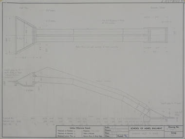 Federation University Historical Collection
Student's Technical Drawing, Engineering Drawings, 1971, 1971
.1) Pencil on paper student's technical drawing 'Sliding roof' .2) Pencil on paper student's technical drawing 'Drainage inlet to river'ballarat school of mines, technical drawing, astbury, donald john, donald astbury, ballarat institute of advanced education, alumni -
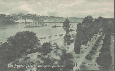 Bendigo Historical Society Inc.
Postcard - THE BOTANIC GARDENS AND BRISBANE RIVER
The Botanic Gardens and River Brisbane. To Florrie (Miss Anderson, Brazier Street Eaglehawk from aunty Ruby, (New Yr, Xmas Wishes). -
Port Melbourne Historical & Preservation Society
Photograph - Yarra River, Ron Laing, 1990s
Part of Ron Laing's collection of photographs recording Port Melbourne over a thirteen year period. Donated to the PMH&PS by the photographer. nb Includes photographs of Victoria Dock in the period of time after the commercial shipping had gone but before the start of the proposed high-rises. The Bolte Bridge which caused this closure of Victoria Dock, North and South Wharves is covered in photos 1319.01-.35.A set of 47 colour photogaphs of the Yarra River at various locations from the old Sandridge Railway Bridge westward to the power house at Newportyarra river, built environment, transport - shipping, ron laing -
Port Melbourne Historical & Preservation Society
Photograph - Ground work for new marina on south side of Yarra, Ron Laing, 1990s
Part of Ron Laing's collection of photographs recording Port Melbourne over a thirteen year period. Donated to the PMH&PS by the photographer.A set of 26 colour photographs covering the ground work for the new marina on the south side of the river below the new harbour control toweryarra river, built environment, ron laing