Showing 5249 items
matching view road
-
 Ringwood and District Historical Society
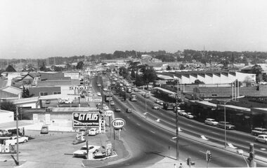
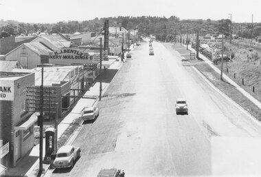
Photograph, Maroondah Highway West, Ringwood- 1969. Westward view from Ringwood Clocktower, cnr Maroondah Hwy and Wantirna Road
Black and white photographWritten on back of photograph: "Dec. 1969 from clock tower - looking west" -
 Ringwood and District Historical Society
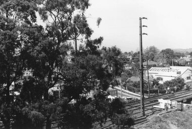
Photograph, View from Ringwood Clocktower overlooking Wantirna Road railway bridge and Thanet Street corner - Dec. 1969
Black and white photographWritten on back of photograph: "Wantirna Rd. from clocktower, 1969." -
 Ringwood and District Historical Society
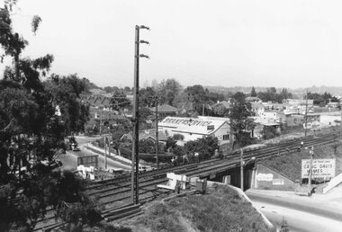
Photograph, View from Ringwood Clocktower overlooking Wantirna Road railway bridge and Thanet Street corner - Dec. 1969
Black and white photographWritten on back of photograph: "Wantirna Rd bridge. from clocktower, 1969". Thanet Street corner. -
 Ringwood and District Historical Society
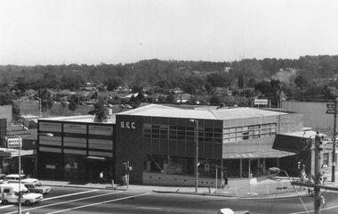
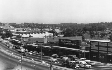
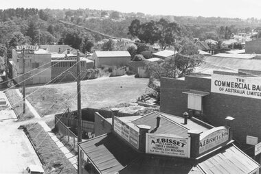
Photograph, Maroondah Highway West, Ringwood- 1969. View from Ringwood Clocktower overlooking Commonwealth Bank and SEC offices, cnr Maroondah Hwy and Ringwood Street, Ringwood - Dec. 1969
Black and white photographNil -
 Ringwood and District Historical Society
Photograph, Maroondah Highway West, Ringwood- 1969. View from Ringwood Clocktower overlooking Main Shopping Centre and Holeproof, Maroondah Hwy
Black and white photographWritten on backing sheet: "Dec. 1969. Holeproof at left". -
 Ringwood and District Historical Society
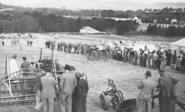
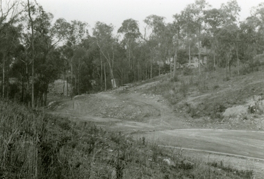
Photograph, Ford Industry Field Day - Loughnan's Hill, Ringwood - April, 1952
Black and white photographWritten on backing sheet- "Mail 10 April 1952. Ford Industry comes to Ringwood. Panoramic view of field day organised and arranged by Allan Coffey Motors showing tractors in operation slashing grass." Included with image- Copy of article in Ringwood Mail dated April 10, 1952,agriculture -
 Ringwood and District Historical Society
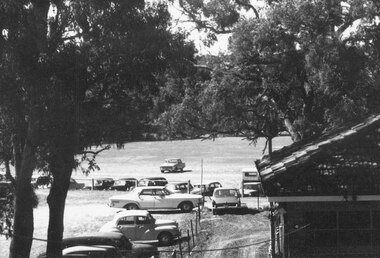
Photograph, View overlooking Ringwood Oval from rear of Town Hall, Maroondah Highway, Ringwood - c.1960s
Ringwood Oval written on back of photograph. -
 Ringwood and District Historical Society
Photographs, 1979-80 MMBW pipe line project at Hubbard Reserve, North Ringwood � View along line work in Hibberd's and Chalkley's
Part of a 43-photo record of the MMBW�s engineering feat in drilling a 12 inch pipe line up to 40 feet deep through rock hardened by volcanic action associated with geological fault that occurs along the line. The work took place from October 1979 to May 1980 on the southern boundary of Hubbard Reserve, North Ringwood. The collection was presented to the Ringwood Historical Research Group by J Clarke on 9th June 1980.E560 N27 Jan 1980 A43 View along line work in Hibberd's and Chalkley's (lot 9 and 8) -
 Ringwood and District Historical Society
Photographs, 1979-80 MMBW pipe line project at Hubbard Reserve, North Ringwood � View behind no. 39 Burlock Avenue showing compressor, mole pit cover and the big box tree
Part of a 43-photo record of the MMBW�s engineering feat in drilling a 12 inch pipe line up to 40 feet deep through rock hardened by volcanic action associated with geological fault that occurs along the line. The work took place from October 1979 to May 1980 on the southern boundary of Hubbard Reserve, North Ringwood. The collection was presented to the Ringwood Historical Research Group by J Clarke on 9th June 1980.E560 N26 Jan 1980 A43 View behind no. 39 Burlock Avenue showing compressor, mole pit cover and the big box tree -
 Ringwood and District Historical Society
Photographs, 1979-80 MMBW pipe line project at Hubbard Reserve, North Ringwood � View east, sewer work line showing grate over pit
Part of a 43-photo record of the MMBW�s engineering feat in drilling a 12 inch pipe line up to 40 feet deep through rock hardened by volcanic action associated with geological fault that occurs along the line. The work took place from October 1979 to May 1980 on the southern boundary of Hubbard Reserve, North Ringwood. The collection was presented to the Ringwood Historical Research Group by J Clarke on 9th June 1980.E560 N30 Feb 1980 A43 View east, sewer work line showing grate over pit -
 Ringwood and District Historical Society
Photographs, 1979-80 MMBW pipe line project at Hubbard Reserve, North Ringwood � View along MMBW work line in east end of Hibberd's, showing grating over mole boring pit
Part of a 43-photo record of the MMBW�s engineering feat in drilling a 12 inch pipe line up to 40 feet deep through rock hardened by volcanic action associated with geological fault that occurs along the line. The work took place from October 1979 to May 1980 on the southern boundary of Hubbard Reserve, North Ringwood. The collection was presented to the Ringwood Historical Research Group by J Clarke on 9th June 1980.E560 N29 Feb 1980 A43 View along MMBW work line in east end of Hibberd's, showing grating over mole boring pit -
 Ringwood and District Historical Society
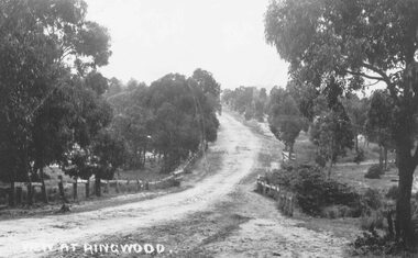
Photograph, Maroondah Highway East, Ringwood- 1870. Sandy Creek, now Ringwood Lake
3 photographs (2 large black and white, 2 small- 1 black and white, 1 sepia) Written on all photographs, "View at Ringwood" Typed below large photograph: "Main St looking east. Right hand side of gully now Ringwood Lake. Written on back of sepia print: "1870, Sandy Creek now Ringwood Lake" -
 Ringwood and District Historical Society
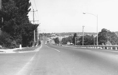
Photograph, Maroondah Highway East, Ringwood in 1973. Eastward view along Maroondah Highway towards Mount Dandenong Road
Black and white photographTyped on back of photograph: "Maroondah Highway by the lake. Looking east towards Mt. Dandenong Rd. - 1973". Ringwood Lake is on the right hand side of the highway. -
 Ringwood and District Historical Society
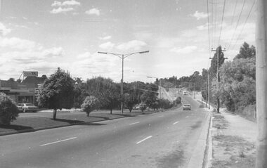
Photograph, Maroondah Highway East, Ringwood- 1973. Westward view from Braeside Avenue along Maroondah Highway
Black and white photographWritten on rear of backing sheet: "Ringwood from Braeside Av. 9/73". -
 Ringwood and District Historical Society
Photographs, 1979-80 MMBW pipe line project at Hubbard Reserve, North Ringwood � Viewing east from Debbie Place
Part of a 43-photo record of the MMBW�s engineering feat in drilling a 12 inch pipe line up to 40 feet deep through rock hardened by volcanic action associated with geological fault that occurs along the line. The work took place from October 1979 to May 1980 on the southern boundary of Hubbard Reserve, North Ringwood. The collection was presented to the Ringwood Historical Research Group by J Clarke on 9th June 1980.E568 N18 13 May 1980 A43 Viewing east from ridge above Debbie Place -
 Ringwood and District Historical Society
Photographs, 1979-80 MMBW pipe line project at Hubbard Reserve, North Ringwood � View east up the gully
Part of a 43-photo record of the MMBW�s engineering feat in drilling a 12 inch pipe line up to 40 feet deep through rock hardened by volcanic action associated with geological fault that occurs along the line. The work took place from October 1979 to May 1980 on the southern boundary of Hubbard Reserve, North Ringwood. The collection was presented to the Ringwood Historical Research Group by J Clarke on 9th June 1980.E568 N19 13 May 1980 A43 View east up the gully, when all the work was finished -
 Ringwood and District Historical Society
Photograph, Maroondah Highway East, Ringwood- 1960. North-easterly view from Ringwood Clocktower, cnr Maroondah Hwy and Warrandyte Road
Black and white photographWritten on back of photograph: "View from clocktower, 1960". -
 Ringwood and District Historical Society
Photographs, 1979-80 MMBW pipe line project at Hubbard Reserve, North Ringwood � View east from Debbie Place
Part of a 43-photo record of the MMBW�s engineering feat in drilling a 12 inch pipe line up to 40 feet deep through rock hardened by volcanic action associated with geological fault that occurs along the line. The work took place from October 1979 to May 1980 on the southern boundary of Hubbard Reserve, North Ringwood. The collection was presented to the Ringwood Historical Research Group by J Clarke on 9th June 1980.E558 N29 13 May 1980 A43 View east from Debbie Place -
 Ringwood and District Historical Society
Photograph, Maroondah Highway East, Ringwood- 1960. Easterly view from Ringwood Clocktower
Black and white photograph (2 copies)Written on back of photographs: "View from clock tower looking east - 1960." -
 Ringwood and District Historical Society
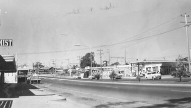
Photograph, Maroondah Highway west, Ringwood- 1965. Easterly view towards Esso petrol station and cool stores on opposite corners of Wantirna Road
Black and white photographWritten beneath photograph, "1965 - Looking east to old cool store site." Written on rear of backing sheet, "1965. Cool store site, corner Maroondah Highway and Wantirna Road". -
 Ringwood and District Historical Society
Photographs, 1979-80 MMBW pipe line project at Hubbard Reserve, North Ringwood � View towards Debbie Place
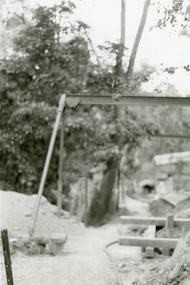
Part of a 43-photo record of the MMBW�s engineering feat in drilling a 12 inch pipe line up to 40 feet deep through rock hardened by volcanic action associated with geological fault that occurs along the line. The work took place from October 1979 to May 1980 on the southern boundary of Hubbard Reserve, North Ringwood. The collection was presented to the Ringwood Historical Research Group by J Clarke on 9th June 1980.E561 N15 3 March 1980 A43 View towards Debbie Place, showing 2 swivel cranes at shafts, timber of manhole in creek, the tracked drill rig and its compressor caravan. -
 Ringwood and District Historical Society
Photographs, 1979-80 MMBW pipe line project at Hubbard Reserve, North Ringwood � Boring mole pit
Part of a 43-photo record of the MMBW�s engineering feat in drilling a 12 inch pipe line up to 40 feet deep through rock hardened by volcanic action associated with geological fault that occurs along the line. The work took place from October 1979 to May 1980 on the southern boundary of Hubbard Reserve, North Ringwood. The collection was presented to the Ringwood Historical Research Group by J Clarke on 9th June 1980.E561 N14 3 March 1980 A43 View west behind No. 29 Burlock Avenue, showing gantry over manhole 38 feet deep. -
 Ringwood and District Historical Society
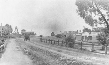
Photograph, Maroondah Highway Central, Ringwood. Main Street looking west from Warrandyte Road- 1908
Black and white photograph (2 copies)Written in lower right corner of photograph, "View near Railway Stn. Ringwood". Typed below one photograph: "Maroondah Hwy looking towards city with Warrandyte Rd coming in from right. Old Station Master's residence on left. Road had two levels here." Bank is E.S. & A. Agency. Bamford's Timber on right. Station Masters house on left. -
 Ringwood and District Historical Society
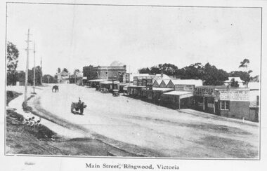
Photograph, Maroondah Highway Central, Ringwood. Main Street, looking west from Warrandyte Rd, c1924
Black and white photograph (2 copies- 1 large, 2 small) Typed below large photograph: "Main St looking west from Warrandyte Rd, c1924." Typed on back of one small photograph: "Coped from a circular for Mountain View Estate, J. Press, vendor, Second Av. Kew. In Mullum Rd, 90 yds from Oban Rd. Press, Rangeview & Mountview Avenues. Winnington just completed. 1924." -
 Ringwood and District Historical Society
Photograph, Maroondah Highway, Ringwood - View of Town Hall - Dec 1969 - 2 Photographs
Black and white photograph of street looking towards Midway Arcade and old town hall.Written on reverse of VC777-1 "Dec 1969 OLD TOWN HALL" -
 Ringwood and District Historical Society
Photographs, 1979-80 MMBW pipe line project at Hubbard Reserve, North Ringwood � View from Debbie Place, preliminary sewer work
Part of a 43-photo record of the MMBW�s engineering feat in drilling a 12 inch pipe line up to 40 feet deep through rock hardened by volcanic action associated with geological fault that occurs along the line. The work took place from October 1979 to May 1980 on the southern boundary of Hubbard Reserve, North Ringwood. The collection was presented to the Ringwood Historical Research Group by J Clarke on 9th June 1980.E561 N13 28 Feb 1980 A43 View from Debbie Place, preliminary sewer work -
 Ringwood and District Historical Society
Photograph, Ringwood Railway Station pedestrian ramp and bridge views - 1976
Two black and white photographs, taken from the pedestrian crossing over the Ringwood railway stationDate written on back of photograph, "Mid 1976". -
 Ringwood and District Historical Society
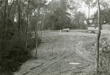
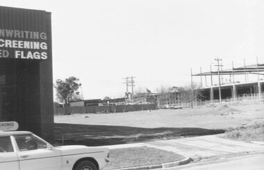
Photograph, Construction work at Target Square, NE corner of Maroondah Hwy and New Street, Ringwood - 1981, 1981
Two views of Target Square shopping complex building under construction.Written on back of photographs - V134a "29-6-81 View from Verstegen's no - New St across Brambles lot at the centre of Target building cnr of Charters-New St on right below Target." - V134b "30-6-81. Looking south from Brambles across Charter St. west end of Target. New St. just out of picture right". -
 Ringwood and District Historical Society
Photograph, Ringwood Oval, Ringwood Street - circa 1918, 1918
Ringwood Oval circa 1920, showing Ringwood Reserve grand stand, tennis courts on the left, and view towards Ringwood Street and Charter Street in the centre backgroun.. The school master's house behind courts was formerly in the Heatherdale Road school in 1885. It was moved in 1892. (See history of Ringwood State School No. 2997).Typed below photograph, "The old Ringwood Reserve grand stand. Tennis courts on the left, looking towards Ringwood and Charter St. in the centre background. ... 1920. (Site) later developed as Eastland carpark, south-west corner." -
 Ringwood and District Historical Society
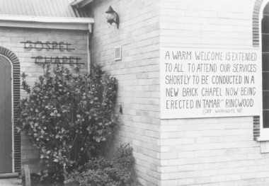
Photograph, Notice of Upcoming Closure of Ringwood Gospel Chapel in Warrandyte Road, Ringwood - 1974, 1974
... (off Warrandyte Road)." Exterior view of Ringwood Gospel Chapel ...Exterior view of Ringwood Gospel Chapel in Warrandyte Road, Ringwood, prior to relocation in 1974.Written on back of photograph, "5.10.74". The board on the Church says, "A warm welcome is extended to all. To attend our services shortly to be conducted in a new brick Chapel ... being erected in Tamar Street, Ringwood (off Warrandyte Road)."