Showing 3596 items
matching white city
-
 City of Kingston
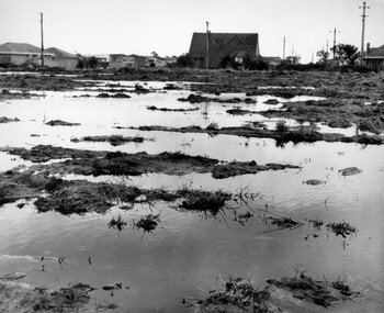
Photograph - Black and white, c. 1958
Unsealed roads and drainage problems created difficulties for those living in Beaumaris during the 1950sBlack and white image depicting the Balcombe Road and Haywood Street, Beaumaris. Unsealed roads and drainage problems have created boggy slushy land. There are houses in the background, indicating people live in the area.Handwritten in red ink on reverse: 90% Handwritten in blue ink on reverse: 2193beaumaris, roads, drainage, water logged, housing -
 City of Kingston
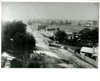
Photograph - Black and white, Percy Fairlam, c. 1910
Black and white image of Cheltenham in the early 20th Century depicts an almost idyllic life. This photo was taken by Percy Fairlam, who climbed a tall pine tree to achieve the aerial view. The tree was a well recognised feature of the Cheltenham skyline but was cut down some time before World War II.Cheltenham was established as a rural market gardening community. The development of the railway was crucial to the ongoing development of the area. Community life sprung up around the railway line which is evident in the proximity of shopping and leisure.Black and white image depicting aerial view down Charman Road, Cheltenham, including the unsealed road, level crossing and shopping centre. What appears to be a cricket pitch is located behind the shops.Handwritten in black ink on a red round sticker adhered to the reverse, and then crossed out: X14 Handwritten in blue ink on reverse: A8 Handwritten in red ink on reverse: 85%cheltenham, railway crossing, roads, housing, shopping strip -
 City of Kingston
Photograph - Colour, 31 January 1993
Patterson Lakes is a suburb in the City of Kingston that is built one kilometre upstream of the mouth of the Patterson River. The area is bordered by the Patterson River and Eel Race Drain which enters the Kananook Creek. The suburb consists predominantly of newer housing developments and the tidal canal system of the development joins Port Phillip Bay. Patterson Lakes and the Kananook Creek were previously part of the extensive Carrum Carrum Swamp. The area was once a source of fish and eels for the Mayone-Bulluk clan of the Bunurong people. Over time the area was drained and in 1973 investigations commenced into the development of a unique residential area that would be built adjacent to canals and waterways. It was originally proposed to be known as "Gladesville". The development would give the suburb's homeowners access to Port Phillip Bay "from their back door". Circa 1974, the area was rezoned from rural to residential and named Patterson Lakes. Development has been continuous since the 1970s with construction of residential housing, schools, shopping centres, marinas, a hotel and library.Laminated colour aerial photograph of the Carrum and Patterson Lakes region within City of Kingston. This 1993 image includes Patterson River Secondary College, Roy Dore Reserve, Kananook Creek and Nepean Highway. The railway line can be seen as it veers inland from Eel Race Road, Seaford. The section of Ocean Reef Drive and Palm Beach Drive in Patterson Lakes appears to be a recent development with many spare blocks and new houses under construction.Black typed lettering on white adhesive label: 31.1.93 Black typed lettering on white adhesive label: 27E/7140 31/1/93 12.55 pm Black typed lettering on white label: 7140 Yellow round adhesive label located on left sidepatterson lakes, seaford, kananook creek, carrum carrum swamp, canals and waterways -
 City of Kingston
Photograph - Black and white, Public Transport Corporation, c. 1960
This image is part of a larger collection of images from the Public Transport Corporation displaying train stations and streetscapes in what is now the City of Kingston.The development of the railway was crucial to the ongoing development of the area. Community life sprung up around the railway line which is evident in the proximity of shopping and leisure.Black and white photograph of railway gates at Centre Road, Bentleigh.Black printed text on a small, round, white sticker on reverse: 227 Handwritten in red ink on reverse: 50% Black typed text on a strip of white paper stuck on reverse: Gates Centre Road Bentleigh / mid 1960 / $50 reproduction fee applies Blue ink stamped on reverse: COPYRIGHT / Public Transport Corporation / For re-ordering photographs / Please quote negative No H 3407 / Enquiries C/- PTC Photographic Unit / Telephone switchboard 619 1111bentleigh, railway crossing, trains, suburbs, shopping strip -
 City of Kingston
Photograph - Black and white, c. 1950
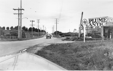
This image shows a sealed road running along South Road, although with a wide gravel shoulder. The railway crossing gates were hand operated. This image is one of many in the collections that focuses on the railway. The development of the railway was crucial to the ongoing development of the area. Community life often sprang up along and beside the railway.Black and white photograph of the railway crossing at South Road, Moorabbin, viewed from Nepean Highway. Handwritten in blue ink on reverse: 217 Handwritten in red ink on reverse: 80%moorabbin, railway, railway crossing -
 City of Kingston
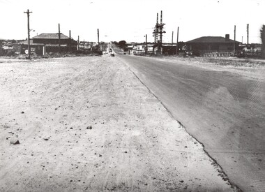
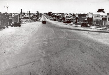
Photograph - Black and white, 1950
This photograph depicts the increasing urbanisation of a once rural area at Moorabbin.This image is one of many in the collections that focuses on either roads or the railway. The development of roads and the railway was crucial to the ongoing development of the area. Black and white photograph of South Road, Moorabbin, with Station Street to the right and Jasper Road further down to the left. Along both sides of the road are retail spaces which become homes on the left hand side, after Jasper Road.Handwritten in red ink on reverse: 80% Handwritten in blue ink on reverse: 216moorabbin, roads, cars, shopping strip, housing -
City of Kingston
Photograph - Colour, 29 January 1993
Bonbeach is a small beachside suburb located between Chelsea and Carrum. The station was opened in 1926 and was the last to be established in the group from Aspendale to Carrum. Urban growth began after World War II. State primary and high schools were opened in 1958 on land in Breeze Street that was once occupied by The Australian Glass Manufacturers. Immediately east of the school sites is the Patterson River Golf Club. The Bonbeach sports reserve has five ovals and is home to the Bonbeach football and baseball clubs. The suburb borders the Edithvale-Seaford Wetlands which is the remnant site of the Carrum Carrum swamp, once the home of the Bunurong people.Bonbeach was originally a seaside destination for holidaymakers and the housing comprised of holiday homes and gradually more permanent residents. It was not until 1926 that Bonbeach had its own railway station. From 1906 until the late 1940s sand was quarried on the east side of the railway line and used in the manufacture of glass. The Australian Glass Manufacturers sold this land in residential blocks and Bonbeach's permanent population spread from the coastal strip across to the other side of the railway line. Laminated colour aerial photograph of the suburb of Bonbeach and also the southern section of neighbouring Chelsea within the City of Kingston. The extent of this 1993 aerial image includes: Top left - Maury Road at the south end of the Chelsea shopping Centre; Top right - Scotch Parade Chelsea Bottom left - Monica Avenue in Bonbeach; Bottom right - Patterson River Golf Club. Landmarks include St Joseph's Church and Primary School, Chelsea Primary School, Bonbeach Station, Bonbeach Fotball Club sports playing fields and Bonbeach Life Saving Club. The Edithvale Wetlands is featured prominently to the right-hand side of the image. Black typed writing on white adhesive label: No. 6662 Black typed writing on white adhesive label: 26E/6662, 29/1/93, 4.25 pm Black typed writing on white adhesive label: 29-1-93 Black typed writing on white adhesive label: P000109 Circular yellow adhesive sticker bonbeach, chelsea -
 City of Kingston
Photograph - Black and white, c. 1950
This image highlights the rural nature of the area during the 1950s where areas that are now major highways and intersections appear like country roads.Black and white photograph of the intersection of Warrigal Road and Centre Road in Oakleigh. There is a truck travelling south toward the camera along Warrigal Road which is a sealed road. On the right hand side is a Caltex petrol station with a street sign for Centre Road.Handwritten in blue ink on reverse: 2191 Handwritten in red ink on reverse: 72%oakleigh, cars, roads, suburbs -
 City of Kingston
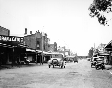
Photograph - Black and white, c. 1925
This image explores the relationship between the train lines and community development. Cheltenham's retail centre is connected to the train station.Black and white image of Charman Road, Cheltenham, depicting a car and truck travelling toward the level crossing near the train station. There is another car already waiting at the crossing gates. Cars are parked on either side of the road along a shopping strip.Black printed text on a white round sticker adhered to the reverse: 141 Handwritten in red ink on reverse: 50% Black typed text on a white strip of paper adhered to reverse: Charman Road, Cheltenham / circa late 1920's/early 1930's / $50 reproduction fee applies Blue ink stamped on reverse: COPYRIGHT / Public Transport Corporation / For re-ordering photographs / Please quote negative ADV 485 / Enquiries C/- PTC Photographic Unit / Telephone switchboard 619 1111cheltenham, trains, railway, railway crossing, shopping strip, cars -
City of Kingston
Photograph - Colour, 1993
Carrum is a suburb in the City of Kingston bordered by the Patterson River in the north and Kananook Creek in the south. To the east the suburb is adjacent to Patterson Lakes. The Carrum Station was opened in 1882, when the railway line from Mordialloc was extended to Frankston. In the early 20th century, it was a destination for holidaymakers occupying tents and cabins. The area now consists of older housing and over time there have been many new housing developments.Carrum is located in the area that was originally part of the Carrum Carrum Swamp. The district had originally been the home of the Bunerong people who fished, gathered food and found refuge in the sand dunes. The Swamp was drained in 1879 when the Patterson Cut was formed and became known as Patterson River. Apart from local farmers, fishermen and hotel-keepers, there were few permanent residents until the early 20th century when it had become popular as a beach resort. In the 1920s and 1930s the area became occupied by more permanent residents.Laminated aerial colour photograph of Carrum and Patterson Lakes in the City of Kingston. The photograph also includes Kananook Creek and the northern section of Seaford. Prominent features include Roy Dore Reserve, Carrum Primary School, Patterson River Secondary College, Keast Park Seaford, the Seaford Swamp Drain and a section of Downs Estate situated on the traditional lands of the Bunurong people.Black type on white adhesive sticker: No. 7140 Black type of white adhesive sticker: 31-1-93 Black handwritten ink (marker): * [an asterisk] Yellow circular adhesive stickerpatterson lakes, seaford, carrum carrum swamp -
City of Kingston
Photograph - Colour, 29 January 1993
Bonbeach, Carrum and Patterson Lakes are suburbs in the City of Kingston. Bonbeach and Carrum were holiday destinations in early 20th century and over time the housing has converted to permanent residential structures. In Patterson Lakes, the area consists predominantly of newer housing developments and the tidal canal system which is accessible to many dwellings joins Port Phillip Bay.Bonbeach, Carrum and Patterson Lakes were previously part of the extensive Carrum Carrum Swamp. The area was once a source of fish and eels for the Mayone-Bulluk clan of the Bunurong people. Over time the area was drained and this allowed farming at Carrum and Bonbeach, although the area was prone to flooding. In the early 1920s and 30s the land was converted to residential dwellings. In 1973 investigations commenced nearby to Bonbeach and Carrum into the development of a unique residential area comprising canals and waterways. It was originally proposed to be known as "Gladesville". Circa 1974, the area was rezoned from rural to residential and named Patterson Lakes. Development has been continuous since the 1970s with staged construction of the waterways, residential housing, and supporting infrastructure and facilities.Laminated colour aerial photograph of the Bonbeach, Carrum and Patterson Lakes region within City of Kingston. This 1993 image includes Bonbeach High School prior to demolition, Bonbeach Primary School and Patterson River Golf Club. Sections of Patterson Lakes are not yet developed, including Rhode and Staten Islands. Long Island Point appears to be a recent development with many spare blocks and new houses under construction. The Patterson River marina is prominent and the river mouth as it meets Port Phillip Bay. The Carrum railway station is visible.Black type on white adhesive sticker: No. 6661 Black type on white adhesive sticker: 26E/6661, 29/1/93, 4.25 pm Black type on white adhesive sticker 29-1-93 Yellow circular adhesive stickerbonbeach, carrum, patterson lakes, patterson river, carrum carrum swamp, canals and waterways -
 City of Kingston
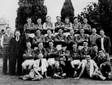
Photograph - Black and white, c. 1940
Members of the Bentleigh football team after presumably winning a premiership as the man seated in the front is holding a cup.Black and white photograph with four rows of men, and one child, grouped together in a traditional sporting photo. Most men are wearing the Bentleigh Football Club uniform but on either side of the third row there are men in street clothes, as are the two men sitting at the front.Black printed text on white round sticker adhered to reverse: 210 Handwritten in red ink on reverse: 72%bentleigh, football, team, sport -
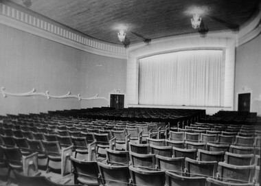
 City of Kingston
Photograph - Black and white, c. 1948
Located in the southern Melbourne suburb of Bentleigh, on the corner of Centre Road and Nicholson Street. The Bentleigh Theatre was opened in 1924. By 1946 it was operated by Hoyts Theatres and was modernised in 1948. It was closed in 1984 and has since been demolished.Black and white photograph of the entrance foyer of the Hoyt's theatre in Bentleigh. On the right hand side is a poster for the movie 'Mother Wore Tights' starring Bette Grable. To the left is the start of a staircase which presumably turns to the left taking movie-goers upstairs.Black printed text on white round sticker adhered to the reverse: 188 Handwritten in red ink on reverse: 80%theatre, movies, entertainment -
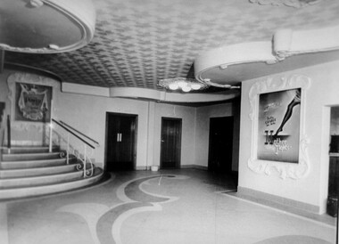
 City of Kingston
Photograph - Black and white, c. 1948
Located in the southeast Melbourne suburb of Bentleigh, on the corner of Centre Road and Nicholson Street. The Bentleigh Theatre was opened in 1924. By 1946 it was operated by Hoyts Theatres and was modernised in 1948. It was closed in 1984 and has since been demolished.Black and white photograph taken from the ground level inside the theatre, with a view of the screen.Black printed text on white round sticker adhered to reverse: 189 Handwritten in red ink on reverse: 72%theat, movies, entertainment -
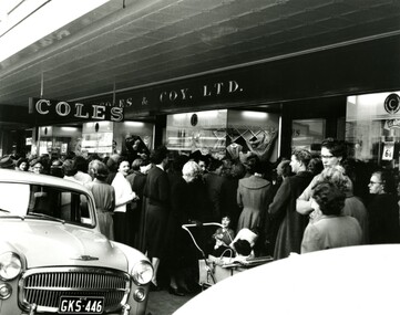 City of Kingston
Photograph - Black and white, 13 September 1956
The newly opened Coles store in Bentleigh attracted a huge crowd of women on opening day.Black and white photograph depicting a crowd of women, some with prams and children, at the entrance to the newly opened Coles store in Bentleigh.Handwritten in blue ink on a white sticker adhered to the reverse: COLES BENTLEIGH / OPENING DAY 13/9/1956 Handwritten in red ink on reverse: 165% Printed black text on a white round sticker adhered to the reverse: 200suburbs, domesticity, shopping, consumerism -
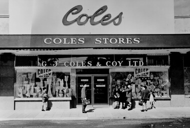 City of Kingston
Photograph - Black and white, 1949
The Coles store in Moorabbin opened in 1949.Black and white photograph depicting the as yet unopened Coles store in Moorabbin with a group of boys standing around the front. The boys don't appear to be taking any particular interest in the store but the photograph provides an excellent view of the facade of the store.Handwritten in blue ink on white sticker on reverse: COLES MOORABBIN / 1949 Printed black text on white sticker on reverse: 203 Handrwitten in red ink on reverse: 70%shopping, consumerism, suburbs -
 City of Kingston
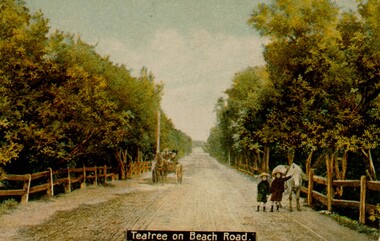
Photograph - Digital image, c. 1914
Digital copy of hand tinted image of two young girls playing on Beach Road, which is lined on either side by tea tree bushes. The girls have a white pony with them and a carriage is coming along the road behind them. -
 City of Kingston
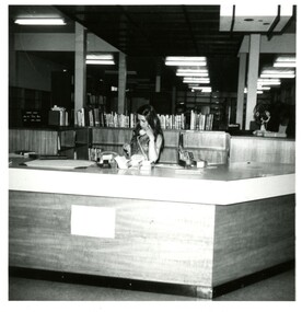
Photograph - Black and white, c.1973
Photograph shows the interior of a library with a presumed staff member on the telephone behind the circulation deskBlack and white photograph showing the interior of a library. A large desk is in the foreground, covered in stationery items and a phone, and with a woman holding a telephone receiver to her ear is standing on the inside of the desk. There are books located on the shelves behind the desk. Fluorescent lights appear at intervals on the ceiling.Printed in grey ink: | 526B Printed in grey ink: 15.11.73library, libraries, staff -
 City of Kingston
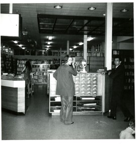
Photograph - Black and white, c.1973
Photograph shows the interior of a library with a woman and man facing the camera and a presumed staff member in the background behind the circulation deskBlack and white photograph of library interior. A woman stands in front of the library catalogue drawers and a man stands to the right of them. Both are looking at the camera. There is a pedestal fan on top of the catalogue drawers. A second woman stands further back, facing away from the camera behind a large desk. Shelves of books can be seen in the background. Printed in grey ink: | 526B / 15.11.73library, libraries, staff -
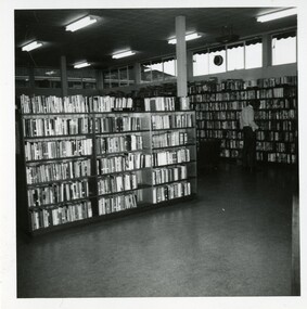
 City of Kingston
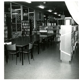
Photograph - Black and white, c.1973
This photograph shows the interior of a libraryBlack and white photograph of the interior of a library showing a large table surrounded by chairs with bookshelves around it Printed in grey ink: |526B / 15.11.73library, librarians, staff -
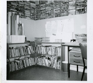
 City of Kingston
Photograph - Black and white, c.1973
This photograph shows the interior of a libraryBlack and white photograph showing the interior of a library. A desk with piles of books on it appears in the right-hand foreground, whilst two large shelves filled with books stand perpendicular to one another in the background. A curtain hangs from the ceiling between the two shelves. Two narrow benches with a pile of books on each stand in the middle of the room.Printed in grey ink: | 526B / 15.11.73library, libraries -
 City of Kingston
Photograph - Black and white, c.1973
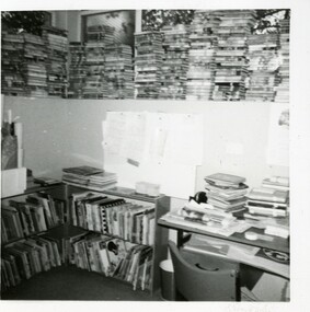
This photograph shows the interior of a library filled with books.Black and white photograph showing two small bookshelves with picture books on them next to half a desk and chair. Above the bookshelves are several rolled up items. Stacked on top of the wall are dozens of books with spines facing inwardslibrary, libraries -
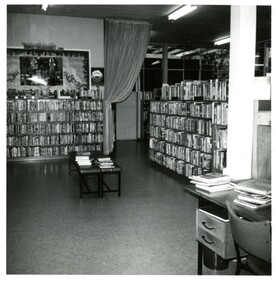
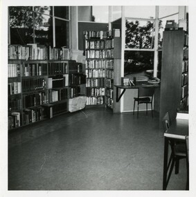
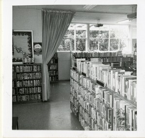 City of Kingston
Photograph - Black and white, c.1973
This photograph shows the interior of a library Black and white photograph of a library interior showing several bookshelves full of books. There is a curtain hanging from the ceiling to the rear of the photograph in front of large windows which are letting in light. A small sign to the left of centre reads 'TEENS CORNER'library, libraries -
 City of Kingston
Photograph - Black and white, c.1978
This photograph shows the interior of a library, including a person looking at the shelvesBlack and white photograph showing the interior of a library with tall bookshelves. A person stands in front of the shelves to the right of the photograph, facing away from the camera and towards the books. A band of high windows looks out onto the sky and the roof of a building next door. Printed in grey ink:| 526B / 15.11.73library, libraries -
 City of Kingston
Photograph - Black and white, c.1978
This photograph shows the interior of a library with desks available for use.Black and white photograph showing the interior of a library. Shelves full of books sit below a window and raise up into a corner. There is a small desk and chair against another window behind a perpendicular shelf filled with books. The corner of a desk can be seen in the right foreground of the photograph. Printed in grey ink: | 526B / 15.11.73library, libraries -
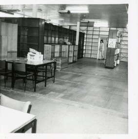 City of Kingston
Photograph - Black and white, c.1973
This photograph shows the interior of a library, possibly a storeroom.Black and white photograph of a library interior, showing tables and chairs, empty floorspace and with empty bookshelves stacked against the left hand wall. There is a box on one of the tables. A woman is walking through a doorway next to a bookshelf containing books in the background of the photograph.Printed in black ink: 868Elibrary, libraries -
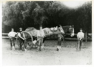 City of Kingston
Photograph - Black and white, c 1900
Black and white photograph of workers with a horse and card preparing the Sandringham Oval, possibly for football. Person 2 and 3 (from L to R) identified as William John Selby and [no first name] McInerneyHandwritten in red ink on reverse: 55% Black printed text on white round sticker adhered to reverse: 48sport, horse, manual labour -
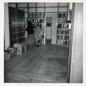 City of Kingston
Photograph - Black and white, c.1973
This photograph shows a library interior with three women in the back corner. Black and white photograph of the interior of a library. There are empty shelves along the left hand wall with boxes on the floor in front of them. Three women are standing in the back corner, two facing away from the camera and one looking towards it. An open door shows a refrigerator in another room. The back wall is shelved with books. There is a large amount of open floor space in the foregroundPrinted in grey ink: | 526B / 15.11.78library, libraries -
 City of Kingston
Photograph - Black and white, c.1973
This photograph shows the interior of a libraryBlack and white photograph of a library interior showing low bookshelves containing picture books, a chair and desk covered in books and stationery. A low wall surrounds the area, on top of which are balanced tall stacks of books with spines facing inwards.library, libraries -
 City of Kingston
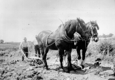
Photograph - Black and white, c. 1920
Horses were frequently used to assist in the manual labour of farming right up to the mid twentieth century. This image was taken while ploughing market garden fields in Moorabbin.Black and white image of two Clydesdale horses attached to harness and pulling a plough. Two men are behind the horses, one is holding the handles of the plough and the other is standing next to him with his hands on his hips.Handwritten in red ink on reverse: 70% Printed in black text on white round sticker adhered to reverse: 41horses, manual labour, farming, moorabbin