Showing 10388 items
matching plan
-
 Port Melbourne Historical & Preservation Society
Document - City of Port and City of South Melbourne, Community Services forward plan, Beris Campbell Collection, 1974 - 1993
Collection of files from Beris CAMPBELL; Port's first Social Worker. Includes local newspapers, flyers and reportsCity of Port Melbourne and City of South Melbourne. Community Services forward plan 1986local government - city of port melbourne, health - general health, politics, public action campaigns, port melbourne citizens action group, port melbourne social welfare centre, city of south melbourne, beris campbell -
Port Melbourne Historical & Preservation Society
Map - West and North Melbourne, MMBW, 21 Feb 1936
Melbourne and Metropolitan Board of Works plan No 24 of West and North Melbourne Docklands,1936signed A.W. Walkermmbw, melbourne and metropolitan board of works, a w walker -
Port Melbourne Historical & Preservation Society
Document - Assignment, Evolution of planning controls for the Port Melbourne foreshore, 1994-2002, Janet Bolitho, May 2002
Assignment (completed while working on post graduate degree) arises from the author's experience of campaigning against high rise development for Port Melbourne as a member of Residents for Responsible Development, 1990sAssignment on the evolution of planning controls for the Port Melbourne foreshore, 1994-2002; 13pp with attachmentstown planning, built environment, public action campaigns, residents for responsible development, janet bolitho, samdy nominees (bayshore), envelope factory (bayview), becton, teac, hmas lonsdale -
Port Melbourne Historical & Preservation Society
Photograph - Sandridge City Development Company plan for proposed Bayside development, Alison Kelly, 1988
Photograph of Sandridge City Development Co. original plan of Bayside development as proposed 1987Has been glued onto MIssion Arts Centre letterhead, then removedtown planning - proposals shelved - bayside, alison kelly, sandridge city development co pty ltd, scdc -
 Cockatoo History & Heritage Group
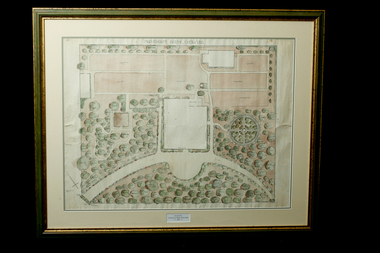
Landscape Plan, Providence House Cockatoo, 1930's
The Presbyterian Church owned three lots of land bounded by Pakenham Road and the northern side of Dorchester Road, between 1927 and 1964. Providence House opened in 1927 as a peaceful country rest home for “tired mothers” from the inner suburbs, and their children. It was also used, at different times, for kindergarten groups and in 1955 for a girls Bible Class for Easter “studies, fun and fellowship.”Cockatoo had several guest houses which took paying guests. Providence House did not charge fees, but is the best-documented of the large houses which provided accommodation.Framed landscape design plan under glass, with detailed plant listings. Original watercolourDonated by Victoria & Digby Newcombe 2003presbyterian church, rest home, landscape plan, garden design, cockatoo victoria, providence house, black n.c, -
 Bendigo Historical Society Inc.
Document - BHS ADMINISTRATION COLLECTION: BRAC FLOOR PLAN, 2008 - 2010
Floor plan of the Bendigo Regional Archive Centre 84 - 86 Nolan Street Bendigo. -
Bendigo Historical Society Inc.
Map - MARONG ALLOTMENTS, 25/08/1906
Map: Plan of Allotments at Marong, Parish of Marong, County of Bendigo. Hand draughted mapmap, bendigo, parish plan, marong, parish of marong -
Bendigo Historical Society Inc.
Map - TOOLLEEN ALLOTMENTS, circa 1870
Map: Parish plan showing Village allotments at Toolleen, Parish of Toolleen, County of Rodneymap, rodney, toolleen, parish of toolleen, county of rodney -
Bendigo Historical Society Inc.
Map - NERRING, August 1952
Map: Nerring, County of Bendigo. Parish plan ( number 180 in Map Cupboard 1)map, bendigo, parish plan, nerring, county of bendigo -
Bendigo Historical Society Inc.
Map - HAWKESTONE, 17/11/1915
Map: Hawkestone, County of Talbot. Parish plan ( number 178 in Map Cupboard 1)map, talbot, parish plan, hawkestone, county of talbot -
Bendigo Historical Society Inc.
Map - HARCOURT, September 1951
Map: Harcourt, County of Talbot. Parish plan ( number 177 in Map Cupboard 1)map, talbot, parish plan, harcourt, county of talbot -
Bendigo Historical Society Inc.
Map - KIMBOLTON, 24/05/1921
Maqp: Kimbolton, County of Bendigo. Parish plan ( number 175 in Map Cupboard 1)map, bendigo, parish plan, kimbolton -
Bendigo Historical Society Inc.
Map - KIMBOLTON, No date Visible
Map: Kimbolton, County of Bendigo. Parish plan ( number 172 in Map Cupboard 1)map, bendigo, parish plan, kimbolton -
Bendigo Historical Society Inc.
Map - WHIRRAKEE, 1971
Map: Whirrakee, County of Bendigo. Parish plan ( number 171 in Map Cupboard 1)map, bendigo, parish plan, whirrakee -
Bendigo Historical Society Inc.
Map - EPPALOCK, 15/11/1928
Map: Eppalock, County of Bendigo. Parish plan ( number 170 in Map Cupboard 1)map, bendigo, parish plan, eppalock -
Bendigo Historical Society Inc.
Map - EGERTON, 1/03/1890
Map: Egerton, County of Bendigo. Parish plan ( number 169 in Map Cupboard 1)map, bendigo, parish plan, egerton -
Bendigo Historical Society Inc.
Map - HUNTLY, August 1945
Map: Huntly, County of Bendigo, Parish plan ( number 168 in Map Cupboard 1)map, bendigo, parish plan, huntly, county of bendigo -
Bendigo Historical Society Inc.
Map - BAGSHOT, November 1948
Map: Bagshot, County of Bendigo. Parish plan ( number 167 in Map Cupboard 1)map, bendigo, parish plan, bagshot, county of bendigo -
Bendigo Historical Society Inc.
Map - LYELL, 16/04/1935
Map: Lyell, County of Bendigo. Parish plan ( number 166 in Map Cupboard 1)map, bendigo, parish plan, lyell, county of bendigo -
Bendigo Historical Society Inc.
Map - MARONG, June 1953
Map: Marong, County of Bendigo. Parish plan ( number 164 in Map Cupboard 1)map, bendigo, parish plan, marong, county of bendigo -
Bendigo Historical Society Inc.
Map - DARGILE, November 1953
Map: Dargile, County of Rodney. Parish plan ( number 162 in Map Cupboard 1)map, rodney, parish plan, dargile , county of rodney -
Bendigo Historical Society Inc.
Map - BENDIGO SHEET 5, May 1949
Map: Bendigo sheet 5 . Parish plan ( number 209 in Map Cupboard 1)map, bendigo, parish plan, bendigo -
Bendigo Historical Society Inc.
Map - BENDIGO SHEET 7, May 1949
Map: Bendigo sheet 7. Parish plan. ( number 208 in Map Cupboard 1)map, bendigo, parish plan, bendigo -
Bendigo Historical Society Inc.
Map - BENDIGO SHEET 7, 1949 ?
Map: Bendigo sheet 7. Parish plan ( number 207 in Map Cupboard 1)map, bendigo, parish plan, bendigo sheet 7 -
Bendigo Historical Society Inc.
Map - SANDHURST SHEET 3, 27/05/1925
Map: sandhurst sheet 3. Parish plan ( number 202 in Map Cupboard 1)map, bendigo, parish plan, sandhurst -
Bendigo Historical Society Inc.
Map - SANDHURST SHEET 3, No date visible
Map: Sandhurst sheet 3. Parish plan ( number 199 in Map Cupboard 1)map, bendigo, city streets, sandhurst -
Bendigo Historical Society Inc.
Map - SANDHURST SHEET 4, January 1947
Map: Sandhurst sheet 4. Parish plan ( number 198 in Map Cupboard 1)map, bendigo, city streets, sandhurst -
Bendigo Historical Society Inc.
Map - SANDHURST SHEET 5, Circa 1940's
Map: Sandhurst sheet 5. Parish plan ( number 197 in Map Cupboard 1)map, bendigo, city streets, sandhurst -
Bendigo Historical Society Inc.
Map - SANDHURST SHEET 6, 1947
Map: Sandhurst sheet 6. Parish plan ( number 196 in Map Cupboard 1)map, bendigo, city streets, sandhurst -
Bendigo Historical Society Inc.
Map - BENDIGO IRRIGATION SETTLEMENT, 20/10/1908
Map: Bendigo Irrigation Settlement, Parishes of Sandhurst and Wellsford, County of Bendigo, Parish planmap, bendigo, irrigation settlement, bendigo irrigation settlement