Showing 5833 items
matching 36
-
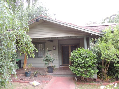
 Surrey Hills Historical Society Collection
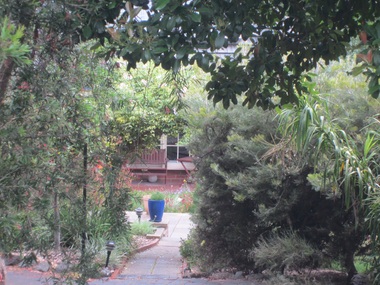
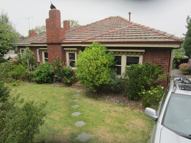
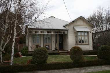
Photograph - 36 Arundel Crescent, Surrey Hills, The Street Where You Live Project
Photos documenting this address as part of a photographic series undertaken by volunteer photographers during 2013 and 2014 for The Street Where You Live Project. This was organised through the Surrey Hills Neighbourhood Centre and covered the postcode 3127 in the cities of Boroondara and Whitehorse.These photos provide a snapshot of real estate in the suburbs of Mont Albert and Surrey Hills during a period of rapid change with many properties on large blocks demolished to create higher density residential development or renewal of single dwellings. At particular risk were properties not covered by heritage overlays, especially interwar housing and post 1950's housing. -
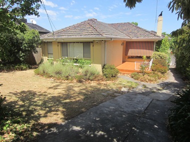
 Surrey Hills Historical Society Collection
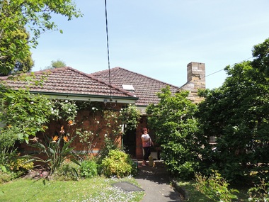
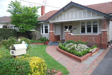
Photograph - 36 Kenmare Street, Mont Albert, The Street Where You Live Project
Photos documenting this address as part of a photographic series undertaken by volunteer photographers during 2013 and 2014 for The Street Where You Live Project. This was organised through the Surrey Hills Neighbourhood Centre and covered the postcode 3127 in the cities of Boroondara and Whitehorse.These photos provide a snapshot of real estate in the suburbs of Mont Albert and Surrey Hills during a period of rapid change with many properties on large blocks demolished to create higher density residential development or renewal of single dwellings. At particular risk were properties not covered by heritage overlays, especially interwar housing and post 1950's housing. -
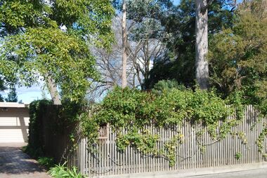
 Surrey Hills Historical Society Collection
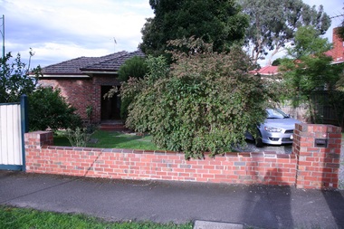
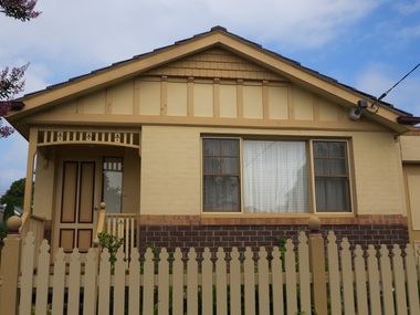
Photograph - 36 High Street, Mont Albert, The Street Where You Live Project
Photos documenting this address as part of a photographic series undertaken by volunteer photographers during 2013 and 2014 for The Street Where You Live Project. This was organised through the Surrey Hills Neighbourhood Centre and covered the postcode 3127 in the cities of Boroondara and Whitehorse.These photos provide a snapshot of real estate in the suburbs of Mont Albert and Surrey Hills during a period of rapid change with many properties on large blocks demolished to create higher density residential development or renewal of single dwellings. At particular risk were properties not covered by heritage overlays, in particular interwar housing and post 1950's housing. -
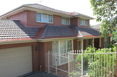
 Surrey Hills Historical Society Collection
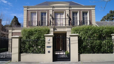
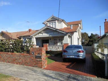
Photograph - 36 Victoria Crescent, Mont Albert, The Street Where You Live Project
Photos documenting this address as part of a photographic series undertaken by volunteer photographers during 2013 and 2014 for The Street Where You Live Project. This was organised through the Surrey Hills Neighbourhood Centre and covered the postcode 3127 in the cities of Boroondara and Whitehorse.These photos provide a snapshot of real estate in the suburbs of Mont Albert and Surrey Hills during a period of rapid change with many properties on large blocks demolished to create higher density residential development or renewal of single dwellings. At particular risk were properties not covered by heritage overlays, in particular interwar housing and post 1950's housing. -
 Surrey Hills Historical Society Collection
Photograph - 36 Lorne Parade, Surrey Hills, The Street Where You Live Project
Photos documenting this address as part of a photographic series undertaken by volunteer photographers during 2013 and 2014 for The Street Where You Live Project. This was organised through the Surrey Hills Neighbourhood Centre and covered the postcode 3127 in the cities of Boroondara and Whitehorse.These photos provide a snapshot of real estate in the suburbs of Mont Albert and Surrey Hills during a period of rapid change with many properties on large blocks demolished to create higher density residential development or renewal of single dwellings. At particular risk were properties not covered by heritage overlays, especially interwar housing and post 1950's housing. -
 Surrey Hills Historical Society Collection
Photograph - 36 Shepherd Street, Surrey Hills, The Street Where You Live Project
Photos documenting this address as part of a photographic series undertaken by volunteer photographers during 2013 and 2014 for The Street Where You Live Project. This was organised through the Surrey Hills Neighbourhood Centre and covered the postcode 3127 in the cities of Boroondara and Whitehorse.These photos provide a snapshot of real estate in the suburbs of Mont Albert and Surrey Hills during a period of rapid change with many properties on large blocks demolished to create higher density residential development or renewal of single dwellings. At particular risk were properties not covered by heritage overlays, especially interwar housing and post 1950's housing. -
 Surrey Hills Historical Society Collection
Photograph - 36 Wandsworth Road, Surrey Hills, On The Street Where You Live Project
Photos documenting this address as part of a photographic series undertaken by volunteer photographers during 2013 and 2014 for The Street Where You Live Project. This was organised through the Surrey Hills Neighbourhood Centre and covered the postcode 3127 in the cities of Boroondara and Whitehorse.These photos provide a snapshot of real estate in the suburbs of Mont Albert and Surrey Hills during a period of rapid change with many properties on large blocks demolished to create higher density residential development or renewal of single dwellings. At particular risk were properties not covered by heritage overlays, especially interwar housing and post 1950's housing. -
 Surrey Hills Historical Society Collection
Photograph - 36 Graham Street, Surrey Hills, The Street Where You Live Project
Photos documenting this address as part of a photographic series undertaken by volunteer photographers during 2013 and 2014 for The Street Where You Live Project. This was organised through the Surrey Hills Neighbourhood Centre and covered the postcode 3127 in the cities of Boroondara and Whitehorse.These photos provide a snapshot of real estate in the suburbs of Mont Albert and Surrey Hills during a period of rapid change with many properties on large blocks demolished to create higher density residential development or renewal of single dwellings. At particular risk were properties not covered by heritage overlays, in particular interwar housing and post 1950's housing. -
 Surrey Hills Historical Society Collection
Photograph - 36 Erasmus Street, Surrey Hills, The Street Where You Live Project
Photos documenting this address as part of a photographic series undertaken by volunteer photographers during 2013 and 2014 for The Street Where You Live Project. This was organised through the Surrey Hills Neighbourhood Centre and covered the postcode 3127 in the cities of Boroondara and Whitehorse.These photos provide a snapshot of real estate in the suburbs of Mont Albert and Surrey Hills during a period of rapid change with many properties on large blocks demolished to create higher density residential development or renewal of single dwellings. At particular risk were properties not covered by heritage overlays, especially interwar housing and post 1950's housing. -
 Surrey Hills Historical Society Collection
Photograph - 36 Grovedale Road, Surrey Hills, The Street Where You Live Project
Photos documenting this address as part of a photographic series undertaken by volunteer photographers during 2013 and 2014 for The Street Where You Live Project. This was organised through the Surrey Hills Neighbourhood Centre and covered the postcode 3127 in the cities of Boroondara and Whitehorse.These photos provide a snapshot of real estate in the suburbs of Mont Albert and Surrey Hills during a period of rapid change with many properties on large blocks demolished to create higher density residential development or renewal of single dwellings. At particular risk were properties not covered by heritage overlays, especially interwar housing and post 1950's housing. -
 Surrey Hills Historical Society Collection
Photograph - 36 Russell Street, Surrey Hills, The Street Where You Live Project
Photos documenting this address as part of a photographic series undertaken by volunteer photographers during 2013 and 2014 for The Street Where You Live Project. This was organised through the Surrey Hills Neighbourhood Centre and covered the postcode 3127 in the cities of Boroondara and Whitehorse.These photos provide a snapshot of real estate in the suburbs of Mont Albert and Surrey Hills during a period of rapid change with many properties on large blocks demolished to create higher density residential development or renewal of single dwellings. At particular risk were properties not covered by heritage overlays, especially interwar housing and post 1950's housing. -
 Surrey Hills Historical Society Collection
Photograph - 36 Ross Street, Surrey Hills, The Street Where You Live Project
Photos documenting this address as part of a photographic series undertaken by volunteer photographers during 2013 and 2014 for The Street Where You Live Project. This was organised through the Surrey Hills Neighbourhood Centre and covered the postcode 3127 in the cities of Boroondara and Whitehorse.These photos provide a snapshot of real estate in the suburbs of Mont Albert and Surrey Hills during a period of rapid change with many properties on large blocks demolished to create higher density residential development or renewal of single dwellings. At particular risk were properties not covered by heritage overlays, especially interwar housing and post 1950's housing. -
 Surrey Hills Historical Society Collection
Photograph - 36 Redvers Street, Surrey Hills, The Street Where You Live Project
Photos documenting this address as part of a photographic series undertaken by volunteer photographers during 2013 and 2014 for The Street Where You Live Project. This was organised through the Surrey Hills Neighbourhood Centre and covered the postcode 3127 in the cities of Boroondara and Whitehorse.These photos provide a snapshot of real estate in the suburbs of Mont Albert and Surrey Hills during a period of rapid change with many properties on large blocks demolished to create higher density residential development or renewal of single dwellings. At particular risk were properties not covered by heritage overlays, especially interwar housing and post 1950's housing. -
 Kew Historical Society Inc
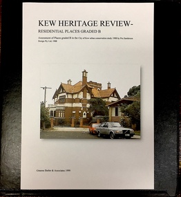
Archive (Sub-series) - Subject File, Kew Heritage Review, Residential Places Graded B, Volume 1, 1999
Graeme Butler & AssociatesProject FilesProvenance OrderBlack 4-Ring binder that includes research about, and an assessment of buildings previously graded B in the City of Kew Urban Conservation Study 1988 by Pru Sanderson Design Pty Ltd. The files were created by the heritage architect Graeme Butler and the paper files include maps, correspondence, title searches, readings, reviews of prior classifications, newspaper and journal articles, directories etc for each property assessed.graeme butler, heritage reviews - kew, 20 yarra street, 8 yarra street, 33 wills street, 25 wellington street, 11 wellington street, 118 walpole street, 84 walpole street, 83 walpole street, 63 walpole street, 52 walpole street, 51 walpole street, 14 vista avenue, 12 tara avenue, 89 studley park road, 75 studley park road, 44 studley park road, 25 studley park road, 13 studley avenue, 21 stoke avenue, 71 stevenson street, 34 stevenson street, 12 stevenson street, 36 stawell street, 11 second avenue, 3 second avenue, 2 second avenue, 34 rowland street, 21 redmond street, 11 redmond street, 16 queen street, 27 princess street, 82 molesworth street, 28 miller grove, 26 miller grove, 24 miller grove, 24 milfay avenue, 8 milfay avenue, 4 merrion grove, 25 mary street, 24 lister avenue, 2 john street, 9 hume street, 7 hume street, 24 howard street, 20 howard street, 19 howard street, 10 howard street, 2 howard street, 26 holroyd street, 12 holroyd street, 73 high street, 69 high street, 35 high street, 6 high street, 53 harp road, 6 gellibrand street, 48 foley street, 9 eglinton street, 25-27 edgecombe street, 21-23 edgecombe street, 5-7 edgecombe street, 23 dunlop avenue, 167 derby street, 8 denmark street, 1 denmark street, 2 daracomb avenue, 2 danielle place, 340 cotham road, 294 cotham road, 241 cotham road, 221-229 cotham road, 208 cotham road, 193 cotham road, 180 cotham road, 171 cotham road, 167 cotham road, 161 cotham road, 135-137 cotham road, 46 clyde street, 4 cameron court, 1291 burke road, 1223 burke road, 1205 burke road, 5 bowen street, 35-37 belford road, 389 barkers road, 387 barkers road, 311 barkers road, 231 barkers road, 83-85 barkers road, 15 adeney avenue, 6 a'beckett streetgraeme butler, heritage reviews - kew, 20 yarra street, 8 yarra street, 33 wills street, 25 wellington street, 11 wellington street, 118 walpole street, 84 walpole street, 83 walpole street, 63 walpole street, 52 walpole street, 51 walpole street, 14 vista avenue, 12 tara avenue, 89 studley park road, 75 studley park road, 44 studley park road, 25 studley park road, 13 studley avenue, 21 stoke avenue, 71 stevenson street, 34 stevenson street, 12 stevenson street, 36 stawell street, 11 second avenue, 3 second avenue, 2 second avenue, 34 rowland street, 21 redmond street, 11 redmond street, 16 queen street, 27 princess street, 82 molesworth street, 28 miller grove, 26 miller grove, 24 miller grove, 24 milfay avenue, 8 milfay avenue, 4 merrion grove, 25 mary street, 24 lister avenue, 2 john street, 9 hume street, 7 hume street, 24 howard street, 20 howard street, 19 howard street, 10 howard street, 2 howard street, 26 holroyd street, 12 holroyd street, 73 high street, 69 high street, 35 high street, 6 high street, 53 harp road, 6 gellibrand street, 48 foley street, 9 eglinton street, 25-27 edgecombe street, 21-23 edgecombe street, 5-7 edgecombe street, 23 dunlop avenue, 167 derby street, 8 denmark street, 1 denmark street, 2 daracomb avenue, 2 danielle place, 340 cotham road, 294 cotham road, 241 cotham road, 221-229 cotham road, 208 cotham road, 193 cotham road, 180 cotham road, 171 cotham road, 167 cotham road, 161 cotham road, 135-137 cotham road, 46 clyde street, 4 cameron court, 1291 burke road, 1223 burke road, 1205 burke road, 5 bowen street, 35-37 belford road, 389 barkers road, 387 barkers road, 311 barkers road, 231 barkers road, 83-85 barkers road, 15 adeney avenue, 6 a'beckett street -
 Kew Historical Society Inc
Archive (Sub-series) - Subject File, Kew Heritage Review, Residential Places Graded B, Volume 2, 1999
Graeme Butler & AssociatesProject FilesProvenance OrderBlack 4-Ring binder that includes research about, and an assessment of buildings previously graded B in the City of Kew Urban Conservation Study 1988 by Pru Sanderson Design Pty Ltd. The files were created by the heritage architect Graeme Butler and the paper files include maps, correspondence, title searches, readings, reviews of prior classifications, newspaper and journal articles, directories etc for each property assessed. graeme butler, heritage reviews - kew, 25 mary street, 4 merrion grove, 24 milfay avenue, 24 miller grove, 26 miller grove, 28 miller grove, 82 molesworth street, 27 princess street, 16 queen street, 20 yarra street, 84 walpole street, 118 walpole street, 11 wellington street, 83 walpole street, 25 wellington street, 8 yarra street, 33 wills street, 63 walpole street, 14 vista avenue, 89 studley park road, 12 tara avenue, 75 studley park road, 21 redmond street, 52 walpole street, 51 walpole street, 71 stevenson street, 34 rowland street, 21 stoke avenue, 34 stevenson street, 44 studley park road, 25 studley park road, 13 studley avenue, 2 second avenue, 11 second avenue, 3 second avenue, 36 stawell street, 12 stevenson streetgraeme butler, heritage reviews - kew, 25 mary street, 4 merrion grove, 24 milfay avenue, 24 miller grove, 26 miller grove, 28 miller grove, 82 molesworth street, 27 princess street, 16 queen street, 20 yarra street, 84 walpole street, 118 walpole street, 11 wellington street, 83 walpole street, 25 wellington street, 8 yarra street, 33 wills street, 63 walpole street, 14 vista avenue, 89 studley park road, 12 tara avenue, 75 studley park road, 21 redmond street, 52 walpole street, 51 walpole street, 71 stevenson street, 34 rowland street, 21 stoke avenue, 34 stevenson street, 44 studley park road, 25 studley park road, 13 studley avenue, 2 second avenue, 11 second avenue, 3 second avenue, 36 stawell street, 12 stevenson street -
 Kew Historical Society Inc
Archive (Sub-series) - Subject File, Kew Heritage Review, Residential Places Graded B, Volume 3, 1999
Graeme Butler & AssociatesProject FilesProvenance OrderBlack 4-Ring binder that includes research about, and an assessment of buildings previously graded B in the City of Kew Urban Conservation Study 1988 by Pru Sanderson Design Pty Ltd. The files were created by the heritage architect Graeme Butler and the paper files include maps, correspondence, title searches, readings, reviews of prior classifications, newspaper and journal articles, directories etc for each property assessed.graeme butler, heritage reviews - kew, 4 cameron court, 2 hodgson street, 20 fellows street, 26 fellows street, 23 highbury grove, kew lunatic asylum, kew mental hospital, willsmere, 36 stawell street, 13 studley avenue, 16 studley avenue, 20 studley avenue, raheen, studley park road, beament house, 33 uvadale road, 20 yarra streetgraeme butler, heritage reviews - kew, 4 cameron court, 2 hodgson street, 20 fellows street, 26 fellows street, 23 highbury grove, kew lunatic asylum, kew mental hospital, willsmere, 36 stawell street, 13 studley avenue, 16 studley avenue, 20 studley avenue, raheen, studley park road, beament house, 33 uvadale road, 20 yarra street -
![Borough of Kew - Gazetted Streets [1865-1937]](/media/collectors/550653872162f11fb04854aa/items/59614050d0cdd511a09c84a0/item-media/59614577d0cdd511a09e80c0/item-fit-380x285.jpg) Kew Historical Society Inc
Kew Historical Society IncDocument, Borough of Kew / Gazetted Streets, 1865-1937
The Melbourne suburb of Kew gained independence from the Boroondara Roads Board in 1860, being declared a Municipality in that year. Kew became a Borough in 1863, a Town in 1910, and a City in 1921. The former City of Kew became part of a newly declared City of Boroondara in 1994. This very fragile document records the following information about streets in Kew - Name, Total Width, Width of Carriageway, Description, Government Gazetted - Year & Page.While the name of a street was formally acknowledged and published in the Victorian Government Gazettes, this document, compiled by a public officer, probably in the Town Clerk's Department, is the earliest known local record listing street names in the Borough, later Town, then City of Kew. The front page indicates that in 1865, the responsibility for an initial 36 streets in Kew was taken over by Council. The final annotation in the document was made in 1937. The document is an important record for researchers seeking to understand the dating of streets in the district.27-page document compiled by officers of the Borough, Town and City of Kew, listing the names of streets taken over by Council, and providing details of their proportions and gazettiing. The document covers the period of 1865 to 1937. Handwritten documentborough of kew, streets -- kew (vic.) -
 Queenscliffe Maritime Museum
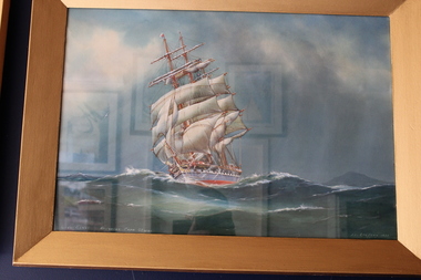
Painting - Water colour painting of the Loch garry, Loch Garry, 1933
Arthur V Gregory b.1867, d.1957 worked from studio at 326 Albert Road South Melbourne established by his father G F Gregory in 1852In her latter years she was still making good passages under Captain Horne, in spite of a shortage of good crews. The following runs are recorded: 1892 Tuskar to Cape Otway 71 days 1894 Downs to Melbourne 77 1895 Lizard to Melbourne 77 1895 Melbourne to Prawle Point 80 1900 Melbourne to Prawle Point 85 1901 Adelaide to Cape Otway 48hr 1903 Port Phillip Heads to Lizard 74 days 1904 Melbourne to Dover 77 1905 Tuskar to Cape Borda 73 1905 Equator to Leeuin 36Water colour painting in painted gilt frameLoch Garry rounding Cape Otway A.V. Gregory 1933a.v gregory, loch garry, water colour -
 Eltham District Historical Society Inc
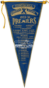
Pennant, Panton Hill Cricket Club 1935-1936 Premiers, 1935
President: H. Howard Secretary: W. Muir Vice Presidents: R. Rogers, A. Duff, G. Muir, R. Howard, G. Hallett, A. Sublet, S. Cracknall, A. Motschall The Team: Albert Howard (Captain), R. Cummings (Vice Captain), R. Cracknall, A. Cummings, R. Cummings Jnr., A. Glennon, Allen Howard, J. Howard, R. Howard, B. Masefield, A. Motschall, F. Motschall, H. Motschall, F. Smith, J. SmithDigital file only - scanned by EDHS from item on loan1935-36 premiers, a. cummings, a. duff, a. glennon, a. motschall, a. sublet, albert howard, allen howard, b. masefield, f. motschall, f. smith, g. hallett, g. muir, h. howard, h. motschall, j. howard, j. smith, lew howard collection, panton hill cricket club, r. cracknall, r. cummings, r. cummings jnr., r. howard, r. rogers, s. cracknall, w. muir -
 Moorabbin Air Museum
Archive (Item) - Box Baa 36 Boeing (Gaf / Asta) Collection
Description: - JINDIVIK DRAWINGS B3B-84-440 TO B3B-84-455 Level of Importance: National. Historical Details: DAP/GAF/ASTA constructed many overseas designs under licence in Australia (Beaufort, Beaufighter, Lincoln, Canberra and F18) however they also designed and constructed a number of significant local designs that were successful in oversea's markets includiEngineering -
Moorabbin Air Museum
Photograph (item) - Photo P547D Thunderbolt ,9th (E.T.O), 36 F.G,23F.S, Photo P547D Thunderbolt
-
Moorabbin Air Museum
Document (Item) - Newsletters 486, 36, 37 Squadrons
Description: ISBN: 0642 244 20 0 Date: 21/07/1995 Author: J. Grimes and B. Lyman Pages: 144 Binding: Permanent - Soft Level of Importance: National. -
Clunes Museum
Work on paper - LEAFLET, 2001
During these celebrations the launch was held of the book "16 Tons of Gold; A History of Port Phillip Mine by author John Woodland. Guests were informed of the dress code for the Colonial Ball .1 A4 buff coloured, printed invitation to 150th Discovery of Gold Celebrations on July 1, 2001 .2 School of Mines Roster for entire week of 150th Discovery of Gold Celebrations .3 Document contains information of the Clunes Colonial Ball held to commemorate 150th Discovery of Gold .4 Invitation to the Miners Walk from Ascot to Clunes Diggings Sunday July 1 2001150th celebrations, school of mines roster 2001, clunes colonial ball guest information, discovery of gold celebration -
Clunes Museum
Document - MINUTES
A4 sheet with details of a meeting held 23 May, 2001 about a Clunes Primary School reunionreunion, clunes primary school, 2001 -
Clunes Museum
Document
The model was returned to Clunes for the 150th Gold Celebrations and installed at the Clunes Primary School for the duration of the celebrations. It has been returned to Melbourne Museum and is stored in their archive. It was build by Carl Nordstrom, Artisan, who built the model in 1858. It took six months to complete at a cost of 215 Pounds. Built on a scale of 3/8 inch to 1 foot.5 x A4 pages containing the history and description and key to the model of the Port Phillip gold mine provided by the curator of the Melbourne Museum.Nilport phillip mine, 1858, nordstrom, scale model -
Clunes Museum
Book - SCRAPBOOK
The newspaper cuttings were taken from publications from 1880-1973 and the subject matter was Clunes, Victoria, AustraliaBrown hardback covered album with cord holding the album together. The album contains newspaper cuttingsnewspaper cuttings, scrapbooks -
Clunes Museum
Magazine, The Local, 2019
Karolina was an artist in Clunes who inspired the refurbishment of the palliative care suite in Creswick HospitalAdvertorial magazine August 26, 2019 Issue 157, page 6, article on Karolina Artistkarolina artist, palliative care -
Clunes Museum
Memorabilia - TICKET, "GUARDIAN" PRINT, CLUNES
Buff coloured with red printing, ticket No.95 for entrance to a patriotic concert held at the Clunes Town Hall for Empire Day 25th May, 1908. Ticket has images of the King and Queen printed on it.concert ticket, clunes town hall -
Clunes Museum
Financial record - LEAFLET, Shire of Talbot & Clunes
The Shire of Talbot & Clunes is now part of Hepburn ShirePrinted leaflet containing information about the Shire of Talbot & Clunes Council's financial revenue and expenditure, (Ratepayer Report 1973)ratepayer's report, shire of talbot & clunes -
Clunes Museum
Programme - CATALOGUE, CTDA, 1974
Catalogue, of paintings, woven articles, pottery for an exhibition 9th November to 16th November 1974. Printed on front cover "The Clunes Tourist and Development Association Catalogue"Some items have a blue biro asterix beside them exhibition, ctda