Showing 25659 items
matching plenty-township-estate
-
 Port Fairy Historical Society Museum and Archives
Photograph
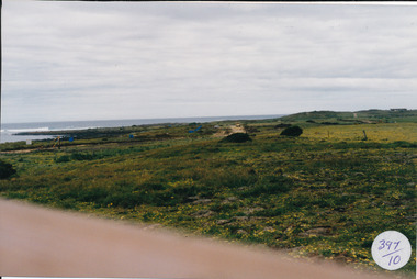
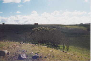
South Beach Development Coloured photograph of South beach estate, blue marks are tree plantings along track397/10 (since removed 2021)south beach, development, road, road making, estate -
 Canterbury History Group
Ephemera - The Enchanted Garden, 1995
Real Estate advertisement for 70 Balwyn Road Canterbury, includes interior and exterior photographs.canterbury, balwyn road, sinclair -
Canterbury History Group
Letter - Letterhead for L. G. Stevens Real Estate Agent, c1920
Photocopy of letterhead of L. G. Stevens Real Estate Agent, Theatre Buildings Canterburycanterbury, maling road, estate agents, l. g. stevens real estate agent, theatre buildings -
Canterbury History Group
Photograph - Street view of shop at No. 2 Bryson Street, Jan Pigot, 1994
Coloured photograph of the street view of Sinclair's Estate Agents shop at No. 2 Bryson Streetcanterbury, bryson street, shops, signs -
Tarnagulla History Archive
Photograph - Photograph: Workers at Tarnagulla Gold Estates N.L, c.1905
Williams Family Collection. Monochrome photograph of workers at Tarnagulla Gold Estates N.L. An original photograph, mounted on card. Handwritten on from: "Tarnagulla Dredge".tarnagulla, people -
Canterbury History Group
Map - Map of Canterbury, Surrey Hills, Mont Albert and Camberwell, c1930s
Map produced and distributed by White & Clarke Real Estate Agents in Canterbury c 1930canterbury, canterbury road, surrey hills, mont albert, camberwell, maps, real estate agents -
Canterbury History Group
Document - The Canterbury - the canterbury, com.au, 1/09/2010 12:00:00 AM
Real estate advertisement for the sale of new development The Canterbury, Canterbury Road September 2010canterbury, canterbury road, jellis craig -
Canterbury History Group
Ephemera - Maling's Estate, 1923
Copy of the advertisng brochure for the sale of 110 building blocks comprising the Maling Estate. c1924surrey hills, duncan & weller, malings estate, whitehorse road, ross street, weybridge street, grovedale road, james street, maling family, land sales, land subdivision -
 Melbourne Legacy
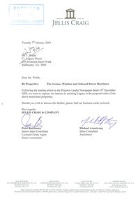
Letter - Document, letter, Sale of properties, 22 Selwood St, Hawthorn East, 9 The Avenue, Windsor, 2003
Two documents that show that in 2003 Melbourne Legacy decided to sell two of its properties, 22 Selwood St, Hawthorn East and 9 The Avenue, Windsor. This decision was taken due to rising maintenance costs and that the money raised from the sale of the properties could be used to benefit all 24,000 widows under their care. One document was a statement by President Tony Parkes about the decision and the other a letter from Jellis Craig offering to be involved in the sale. They had read about the decision in the Leader newspaper. No time frame had been set and all residents of these two properties would be consulted by Legacy personnel with a family member present. Also photocopies of the two land titles for the properties.This shows the commitment of Melbourne Legacy to ensure that residents individual circumstances, accomodation, needs preferences and location were considered in the move, and cause as little disruption to the residents as possible.Cream A4 paper, plus brochure from real estate agent, Jellis Craig,Stamped 'Received 09 JAN 2003 Melbourne Legacy' in blue ink, top left hand corner. Top centre Jellis Craig letter head. Letter signed Peter Batrouney and Micheal Armstrong (Jellis Craig).widows, properties, titles -
 Ballarat Tramway Museum
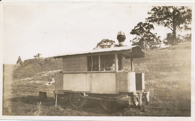
Photograph - Former Bendigo Steam motors at David Mitchell Estate, Ray Pearson, c1930
Two black and white photographs of former Bendigo steam motor No. 2 at the David Mitchell estate railway, Lilydale district, photographed c1930. Reference Light railways 208, August 2009, page 9.Yields information about a former Bendigo steam motor.Black and White copy print contained within the Wal Jack Bendigo and Geelong Album, see Reg Item 5003 for more details. .1 - On rear in ink "Steam motor from the Bendigo steam tramway's (rebuilt). This was taken at the David Mitchell Estate at Lilydale used to run to the Mt Evelyn about 6 miles. Broken up after this photo was taken" Similar notes on rear of Ken Magor collections with the additional detail of photographer - Ray Pearson.trams, tramways, bendigo, steam trams, light railways, tram 2 -
Kew Historical Society Inc
Plan - Charteris Estate, Ivanhoe [East], 1927
Subdivision plans and real estate flyers/brochures reveal a number of aspects of urban development and history. The Kew Historical Society's collection of these plans, as well as advertisements extracted from magazines, cover key aspects of community development and architectural history of Kew and Kew Eat as well as surrounding suburbs. While most of the plans in the collection were gifted to the Society by the former City of Kew, a number of other plans and advertisements have been donated by individuals, of which this is an example.Original 4-page bifold handout advertising 43 residential lots for sale in the Charteris Estate subdivision in Ivanhoe [now classified as Ivanhoe East]. This brochure was created to sell the third section of the estate which it labels as 'The Most Superb Section'. Streets within the subdivision include: Burke Road North, McArthur Road, Castella Street, and the Government Boulevard. In addition to the overall plan spread across pages 2 and 3, each page includes a number of interesting photographs including: a number of the new Burke Road Bridge, a sports ground, Hoyts Picture Theatre in Ivanhoe, a croquet ground, and Ivanhoe shopping centre [named Motor Cross Junction].charteris estate - east ivanhoe (vic), subdivision plans -- ivanhoe east (vic.), d.c. mcarthur, charterisville -
 Federation University Historical Collection
Photograph, Ballarat 1852
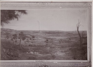
Photograph of a framed oil painting titled 'Ballarat 1852 Tent Settlement from Black Hill. Shows Ballarat Flat, Golden Point township. Black Hill Flat and Sebastopol.ballarat, black hill, golden point, ballarat flat, tents, settlement, black hill flat, sebastopol -
Phillip Island and District Historical Society Inc.
Newspaper clippings, 1888
Griffith Point had earlier been so named after Mr Griffiths, a fisherman.The Argus, July 9, 1888. At a public meeting, the inhabitants of Griffiths Point decided unanimously on the suggestion of Mr Fraser that the name of the newly proclaimed township should be named San Remo.local history, documents, newspapers, griffiths point, black & white newspaper clipping, griffiths point, the argus july 9 1988 -
Glenelg Shire Council Cultural Collection
Painting, George H.L Pentland, Casterton 1889, 1889
Casterton & District Historical Society Inc.Painting, oil on canvas showing a 'bird's-eye' view' of the township of Casterton in the late 19th century. It shows the Glenelg River, the bridge, main street and rolling landscape of the Western District.casterton, oil painting, landscape -
 Kiewa Valley Historical Society
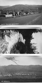
Photos - Mt Beauty and surrounds
B & W photos - Mt Beauty township; Earthmoving Equipment opposite workshops; Kiewa River; Mt Bogong view all with the titles written on the bottom left hand cornerKiewa River; Mt Bogong; Earth Moving Equipment; Mt Beauty -
Glenelg Shire Council Cultural Collection
Photograph - Photograph - Portland central township and Portland Harbour, 05/03/1971
Port of Portland Authority archivesFront: (no inscriptions) Back: (no inscriptions)port of portland archives, portland harbour, portland central town, no6 berth development, ocean pier demolition, baths demolition -
 Bendigo Historical Society Inc.
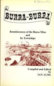
Book - STRAUCH COLLECTION: BURRA BURRA
Soft covered book titled Burra - Burra, Reminiscences of the Burra Mine and Its Townships compiled and edited by Ian Auhl, 160 pages with maps, black and white photographs & illustrations.Ian Auhlhistory, australian, burra burra, history-south australia-burra-mining -
 Bendigo Historical Society Inc.
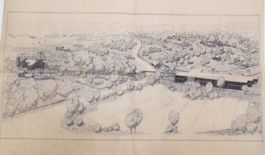
Drawing - MINING IN BENDIGO COLLECTION: SKETCH OF MINING AREA
Pen and ink sketch of a mining scene. Sketch shows poppet legs and mine buildings, overhead mine structures, railway, township, miners cottages in a bush setting. Artist unknownart, mining in bendigo, sketch of mining area -
Lakes Entrance Regional Historical Society (operating as Lakes Entrance History Centre & Museum)
Book, Johnsonville Primary School, Johnsonville Primary School No 2761 Centenary 1886-1986, 1986
A detailed description of Township of Johnsonville Victoria. Giving the original details of the school and building surrounding with names of the original settlers. Many descriptive and captioned homesteads date range 1886-1986.schools, settlers, township, boats and boating -
Lakes Entrance Regional Historical Society (operating as Lakes Entrance History Centre & Museum)
Book, Judy Hartley, Stories from Wairewa, 2018
A collection of photographs facts and history from the proclamation of the settlement and township in the Victorian Gazette of December 1888 until becoming the thriving community in 1988 Nowa Nowa East Gippsland Victoriatownship, timber industry, railways -
Lakes Entrance Regional Historical Society (operating as Lakes Entrance History Centre & Museum)
Postcard, A Cooper photograph, 1910 c
Easter Greetings written on back of card to Dear Will from your loving girl DorisSepia toned postcasrd of view of North Arm bridge and looking across township Cunninghame Arm to hummocks hand coloured flowers down the left side Lakes Entrance Victoriatransport, roads and streets -
 Clunes Museum
Photograph, 2006
16 COLOURED PHOTOGRAPHS OF POWDER MAGAZINE, SITUATED IN A PADDOCK ON SMEATON ROAD APPROX, 2KM FROM TOWNSHIP ON LEFT HAND SIDE. IN DISTANCE TREES IN THE FOREGROUND SOME BOULDERS SHOWN.local history, photography, photographs, mining -
 Clunes Museum
Photograph, KODAK, 1999
VIEW OF POWDER MAGAZINE USED IN MINING DAYS AT CLUNES TO STORE EXPLOSIVES. BUILDING MATERIALS SOLID BRICKCOLOURED REPRINT OF POWDER MAGAZINE, SITUATED IN A PADDOCK ON SMEATON ROAD APPROX. 2 KM. FROM TOWNSHIP ON LEFT HAND SIDE. IN DISTANCE TREES IN THE FOREGROUND SOME BOULDERS SHOWN.local history, photography, photographs, mining -
 Lakes Entrance Regional Historical Society (operating as Lakes Entrance History Centre & Museum)
Photograph, Phillips, Miss L, 1910c
Black and white photograph of North Arm. It shows the reedy shoreline in foreground, jetty to island in lake, two small boats on water, distant view of township. Lakes Entrance Victoriawaterways, topography, vegetation -
 Lakes Entrance Regional Historical Society (operating as Lakes Entrance History Centre & Museum)
Photograph, Nelson Joan, 1980c
Colour photograph of a crowd on the beach at the southern shore of Cunninghame Arm. It shows many people enjoying the sand and water, footbridge and northern shore of township in distance. Lakes Entrance Victoriawaterfront, parks, restaurant -
Lakes Entrance Regional Historical Society (operating as Lakes Entrance History Centre & Museum)
Photograph
Black and white photograph SHOWING TRACK THROUGH VEGETATIONON SAND HUMMOCKS WITH DISTANT OCEAN Part of western end of township across Cunninghame Arm in distance Lakes Entrance Victoriatopography, information -
Lakes Entrance Regional Historical Society (operating as Lakes Entrance History Centre & Museum)
Photograph, 2005
Colour aerial photograph showing North Arm, township, eastern end of Cunninghame Arm across to the ocean beach, Ninety Mile beach, Bass Strait Lakes Entrance Victoriaaerial photograph, aircraft -
Clunes Museum
Map - CLUNES 1987, PRODUCED BY CHARLES FENTON, 1987
.1 .2 A MAP OF CLUNES TOWNSHIP - ORIGINAL AND COPY - 1987. ALL STREETS AND BIRCH'S CREEK MARKED WITH ALLOTMENT NUMBERS. .3 SAME MAP SHOWING PATH OF BUSHFIRE IN 1944CLUNES 1987local history, document, maps, clunes township -
Clunes Museum
Photograph, TOWN OF CLUNES, 1886
CLUNES TOWNSHIP IN 1886BLACK WOODEN FRAMED PHOTOGRAPH OF CLUNES. HAND TINTED WITH A NARRATIVE WHICH WAS GLUED ONTO THE GLASS. VIEW LOOKING SOUTH NEAR THE PRESENT DAY SCENIC ROAD LOOKOUT.colonial and indian exhibition in london 1886, bute & downes amalgamated, buildings, mining -
 Wangaratta RSL Sub Branch
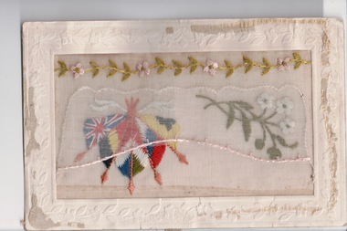
Embroidered Postcard, c. 1916
Postcard from WWI soldier William West (1268) of the 29 Infantry Battalion, 5th Pioneers Battalion while posted in France to his family at home.Embroidered silk postcards were first made in 1900 for the Paris Exposition. The popularity of silk postcards peaked during the First World War 1914 - 1918.They were mostly embroidered by French women in their homes and then sent to the factories for cutting and mounting on cards. Many of the cards were illustrated with patriotic symbols, flags, slogans, or sentimental texts. During the First World War, many Allied officers and soldiers based in France sent silk embroidered postcards to their loved ones back homeWhite rectangular postcard with embroidered flags, foliate and flowers. Handwritten message on back.Back: "My dear Alice / just a PC to let you ???? Joe ??? well and hope you are all the same / plenty of beer / best love Will xxxx"wwi, postcard, embroidered postcard, carte postale