Showing 10728 items
matching sites
-
 Cheese World Museum
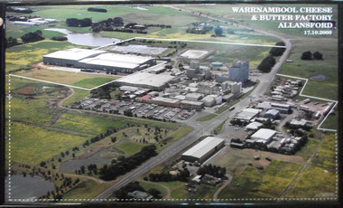
Photograph, Warrnambool Cheese and Butter Factory Co Ltd site 2000 -aerial view, 2000
Warrnambool Cheese and Butter Factory Company was formed by a group of Warrnambool business men. The company was registered in May 1888 and commenced commercial production in November 1888. The company retained its independence for more than 125 years until acquired by Canadian firm Saputo. It has operated from the same site since its inception and also has an office in Japan. Milk processing is undertaken by Sungold. Milk powder for export is also produced on-site. Cheese World is a retail arm of the company operates on a connected site selling company products, local food products, wine and cheese tasting. Cheese World Museum operates under the Cheese World umbrella.Aerial colour photograph of Warrnambool Cheese and Butter Factory in wooden frame. Shows buildings and surrounds. Lines indicate factory boundaries, dotted lines indicate property extension. Date is recorded on the image.17.10.2000allansford, warrnambool cheese and butter factory company, saputo, dairyiing, dairy manufacturing, diary manufacturers, cheese, butter -
 Ballarat Tramway Museum
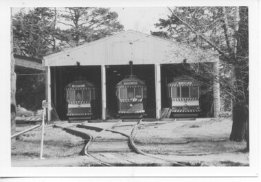
Photograph - Black & White Photograph/s - set of 8, late 1978, early 1978
Yields information the construction of the depot fan and access track to Wendouree Parade and has a strong association with the workers in the photograph.Set of eight Black and white photographs of the extensions to the tram depot and commencement of the trackwork to lay the King points, late 1978, early 1979. .1 - View from south of the level crossing showing the depot front - note the road numbers and sign at the front have been taken down. The steelwork for the depot extension has been erected. .2 - site for the King points with the track materials lay roughly out alongside . .3 - No. 27 in front of 40 on 3 road. .4 - sleepers interlaced for the King Points .5 - all the future materials laid out on the avenue - was like this for a long time .6 - King point materials looking with the mound of earth in the background. .7 - close up of the site of the King point, with the trolley in the background. .8 - rear view of the depot showing the steelwork that had erected. trams, tramways, depot construction, btps, operations, trackwork, tram 27 -
 Kew Historical Society Inc
Album - Victorian Canoe Club : Album 2, 1920-30
Canoeing on the River Yarra at Melbourne was an important and widespread recreational pursuit for Melbournians, especially in the first half of the twentieth century. The Victorian Canoe Club was formed in 1912 at a meeting in Melbourne and its first committee elected in the same year. Records indicate that the Club continued into at least the 1950s .The album has historic and social significance as a record of recreational activities (as well as canoe making) in the early years of the twentieth century. It has local significance as the site of the headquarters of the Club was in Studley park. A number of photographs in the album provide vistas of Kew on the Yarra that are otherwise unavailable.24 labelled photos in part album, originating from the Victorian Canoe Club, which had its headquarters in Studley Park, Kew. The album includes a photographic record of canoe construction and also locations in Studley Park and Kew where the canoes were used. Descriptive titles in the album include (sometimes referring to two photos): Steaming gear / Mould for racer / Ribs bent on mould / Planking [3] / Planking racer / Planking Nagha / Planking completed / Off mould / Built-up ends and deck frames / Racer completed (Retriever) / Nagha & Dnapna completed / V.C.C. Studley Park / On the Yarra / Through the rapids / Yarra near Bourke [sic] Rd [2] / Camp site near Bourke [sic] Rd / Dyghts [sic] Falls, Studley Park [2] / V.C.C. site, Studley Park / Y.M.C.A. Camp, Mornington.Each photograph is labelled in white inkvictorian canoe club, canoe making, river yarra, burke road, mornington, studley park, kew -
 Kiewa Valley Historical Society
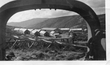
Photograph - Pretty Valley camp including workman's huts, Pretty Valley
At the Pretty Valley Dam site erection of staff quarters was completed in April, 1947 and accommodation for workmen commenced in 1948 but suspended on 11th May for winter and resumed on 9th November. Construction of this camp was completed in 1949. A large dam was proposed at this site but was never constructed. Instead a small diversion dam was built which diverts water either to Rocky Valley Dam or to McKay Creek Power Station.An historical record of the type of accommodation provided for workmen during the construction of the Kiewa Hydro Scheme during the 1940's/50'sBlack and white photograph of Pretty Valley camp showing workman's huts and construction materials.Handwritten on back of photograph in blue pen - Pretty Valleypretty valley, workmen's huts, victorian alps, secv -
 Warrnambool and District Historical Society Inc.
Document, Sticker Warrnambool Botanic Gardens 150 years A Growing Legacy, 2016
This sticker was issued to celebrate the 150th anniversary of the Warrnambool Botanic Gardens. These Gardens were first established in the early 1850s on a site near the mouth of the Hopkins River but this site proved unsuitable and the Gardens were moved to the present location (Cockman Street/ Botanic Road) in 1866. In 1877 William Guilfoyle was commissioned to provide a plan for the Botanic Gardens . A prominent curator was Charles Scoborio 1872 to 1906. This sticker is a minor interest as a memento of the 150th anniversary in 2016 of the Warrnambool Botanic Gardens A white sheet of paper containing a circular shaped sticker with blue print and a logo in green and purple. The printing is in black and purple.Warrnambool Botanic Gardens 150 years A GROWING LEGACYwarrnambool botanic gardens, william guilfoyle -
 Kiewa Valley Historical Society
Photograph of Pretty Valley Camp, Pretty Valley Camp, circa 1948
At the Pretty Valley Dam site erection of staff quarters was completed in April, 1947 and accommodation for workmen commenced in 1948 but suspended on 11th May for winter and resumed on 9th November. Construction of this camp was completed in 1949. A large dam was proposed at this site but was never constructed. Instead a small diversion dam was built which diverts water either to Rocky Valley Dam or to McKay Creek Power Station.An historical record of the type of accommodation provided for workmen during the construction of the Kiewa Hydro Scheme during the 1940's/50'sBlack and white photograph of Pretty Valley Camp showing general terrain and the huts built to accommodate workmen employed on the Kiewa Hydro Electric Scheme.pretty valley, dam, water, workmen, camp -
 Federation University Historical Collection
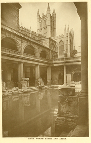
Postcard - Postcard - Sepia, Bath, Roman Baths and Abbey
The Roman Baths complex is a site of historical interest in the English city of Bath. The house is a well-preserved Roman site for public bathing. The Roman Baths themselves are below the modern street level. There are four main features: the Sacred Spring, the Roman Temple, the Roman Bath House and the Museum, holding finds from Roman Bath. The buildings above street level date from the 19th century. Three sepia postcards with a photographic impressions of the Roman Baths, Abbey, and Grand Pump Room, Bath. All postcards unwritten..3) Bath. Roman Baths and Abbey. Within the distance of a few yards are the Roman Baths, built about A. D. 55 ; the Abbey, erected in 1499 : the King's Bath of 17th and 18th century construction, and the modern Bathing establishment containing the latest scientific appliances for the administration of the radio-active waters for the cure and relief of many complaints.bath, roman baths, roman, archeaology -
 Federation University Historical Collection
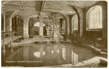
Photograph - Black and White, The Photochrome Co. Ltd, Bath
The Roman Baths complex is a site of historical interest in the English city of Bath. The house is a well-preserved Roman site for public bathing. The Roman Baths themselves are below the modern street level. There are four main features: the Sacred Spring, the Roman Temple, the Roman Bath House and the Museum, holding finds from Roman Bath. The buildings above street level date from the 19th century. . Two black and white postcards of views of Bath. .1) Roman Circular Bath .2) Empire Hotel and Bridge, Bathchatham family archive, roman, bath -
Federation University Historical Collection
Plan, Proposed New Buildings for the Ballarat School of Mines, 1966, 05/1966
The Diploma Subjects Building was designed to be erected on the M.B. John Factory site (Lydiard Street towards Armstrong St), to provide facilities for the tertiary sector of the Ballarat School of Mines. This proposal was aborted when the Mount Helen Campus site was acquired and a new campus started there in 1967. Many of the laboratories shown in these plans were incorporated, in modified form, in single-storey buildings on Mt Helen campus.Plans for proposed building for Diploma students at the Ballarat School of Mines. The building was not built.ballarat school of mines, proposed buildings, l.h. vernon and associates -
 Hume City Civic Collection
Photograph - Our Lady of Mt. Carmel School
The building is Our Lady of Mount Carmel School which is attached to the Catholic Church of the same name. Initially a school was established on this site in 1877 with classes conducted in the church. A new two roomed brick building was erected on the site on 23rd January 1916 and were opened by Archbishop Mannix. There were further additions to the school as enrolments increased in 1925. The school caters for primary school aged students. The school has been functioning in Sunbury for almost 150 years.A coloured of a single storey red brick building with white trims and a red painted iron roofour lady of mount carmel church, our lady of mount carmel primary school -
 Sunbury Family History and Heritage Society Inc.
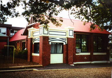
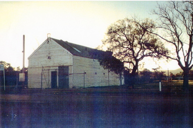
Photograph, c 1940s
The building was the former Sunbury Fire Station. It was in Evans Street on the site where the shopping square has been built. Mount Holden can be seen in the background. A newer building was built for the CFA on the opposite side of Evans Street and closer to Macedon Street. As the shopping centre expanded and Sunbury grew, the CFA moved from the town centre to a site in Jackson Street and another one in Elizabeth Drive.Over the years the CFA has played an important role in numerous fire fighting activities over summer months.A scanned coloured photograph with a fine white border of an old weatherboard building with a metal roof by an unmade roadway. A hill is in the background and two bare trees are growing near the building.sunbury cfa. -
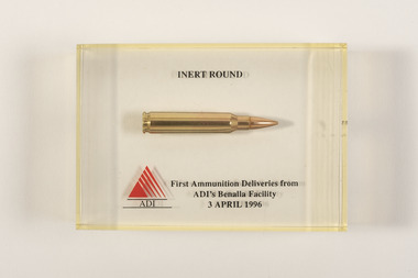 Beechworth RSL Sub-Branch
Souvenir - Cartridge, Memorial, 3 April 1996
Australian munitions is the largest supplier of explosive munitions to the Australian Defence Force. Australian Munitions can trace its ammunition heritage back to the late 19th century, through the establishment of the Colonial Ammunition Company in Victoria. Manufacturing is based at two main regional sites – Benalla in Victoria and Mulwala in New South Wales. The Benalla site produces ammunition, explosive ordnance and other munitions.This cartridge represents the first ammunition delivery from the site upon its opening in 1996.Single 5.56mm cartridge, encased in resin. Text and images on resin."INERT ROUND" "First Ammunition Deliveries from" "ADI'S Benalla Facility" "3 April 1996"cartridge, ammunition, round, adi, australian munitions, bullet -
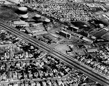 City of Kingston
Photograph - Black and white, c. 1970
The Highett Gas Works were a landmark along the Nepean Highway for many years. With the cessation of the gasification of coal and the introduction of natural gas to Victoria, the gas holders were demolished and the Sir William Fry Reserve was developed on the southern end of the site. The Gas and Fuel redeveloped the northern end of the site with modern offices and laboratories for the organisation's scientific services. At this time, the chimney and retort house were retained.The Highett Gasworks had its beginning in 1939 operated by the Central Brighton and Moorabbin Gas Co Ltd. The company had expanded its gas production facilities to Highett where it had purchased 45 acres of land adjacent to the Melbourne-Frankston railway line. The first gasholder was erected on the Highett site in 1927 and connected with high pressure mains to the Brighton Gas Works. In 1939 the building program including gasometers, the vertical retort house and coal store was completed and gas making commenced. Its area of supply covered approximately 70 square miles and included the municipalities of Brighton, Sandringham, Moorabbin, Mordialloc, Chelsea and part of Dandenong. The Gas and Fuel Corporation eventually took over operations and with the disaggregation and privatisation of the organisation, the site was eventually closed c. 2002.Black and white aerial photograph featuring the Highett Gas Works with gasholders and retort house. In the top right-hand corner, a former Highett Primary School on Graham Road can be viewed. Photograph includes Bay Road, Royal Avenue, Princess Avenue and Jackson Road (Highett) and Alfred, Turner and Sandford Streets (Moorabbin).Handwritten in black ink: [indecipherable] in a circle Handwritten in red ink: 70% Four velcro display adhesivesgasification of coal, gas and fuel corporation of victoria, gasholders, highett, moorabbin, utilities -
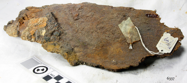 Flagstaff Hill Maritime Museum and Village
Wood encrustation, 1855
The object is a mass of small shipwreck debris that has been concreted together by sediment and marine growth. It was retrieved from the wreck-site of the SCHOMBERG, which ran aground near the mouth of the Curdies River near Peterborough in 1855. The conglomerate of preserved wood impressions, rusted metal pieces, a small square of copper alloy, and black glass-like stones, presents too disjointed a collection to provide information on their purpose or function on the ship. The natural and gradual process of limestone accretion is a significant feature of the wreck-site, which was rediscovered by fishermen and skindivers in 1973. In his book “Exploring Shipwrecks of Western Victoria”, experienced diver and former director at Flagstaff Hill, Peter Ronald writes that the SCHOMBERG’s “triple layered wooden hull has disintegrated almost without trace…The turbulent shallow waters have promoted particularly heavy marine growth which tend to disguise the wreckage…the most prominent feature being a corroded mass of railway iron…Close inspection reveals small artefacts firmly embedded in the marine concretion which…is quite literally as hard as iron”. The huge oblong mass of concretion that now distinguishes the site covers the remains of this heavy cargo. A contemporary account of the SCHOMBERG’s fate (told by two of her passengers to the Melbourne Argus) alleges the ship “was overloaded, drawing over 25 feet when she left, and the cargo was chiefly iron and plant for the Geelong Railway”. The SCHOMBERG was a 2,000 ton clipper ship, specifically designed for the Australian immigration trade (back-loading wool for Britain’s mills), and constructed in Hall’s shipyard in Aberdeen, Scotland. She was owned by the Black Ball Line and launched in 1855. Alexander Hall & Son were renowned builders of sleek and fast 1,000 ton clippers for the China trade (opium in, tea out) and were keen to show they could also outclass the big North American ships built by Donald Mackay. Consequently the SCHOMBERG was ‘overbuilt’. Her hull featured five ‘skins’ of Scotch Larch and Pitch Pine overlaying each other in a diagonal pattern against a stout frame of British Oak. Oak has been favoured by builders of wooden ships for centuries. Its close, dense grain made it harder to work, but also gave it great strength and durability. In addition, the lateral spread of its branches supplied a natural curvature for the ribs of a vessel’s hull, as well as providing the small corner or curved pieces (‘knees’ and ‘elbows’) that fit them together. The shape and texture of this wood sample suggests a dense hardwood like Oak. The timber has been cut off at one end since its recovery from the sea, exposing a smooth and almost shiny surface. Seasoned English Oak has a similar light brown colour and tight grained finish. At the launch the SCHOMBERG’s 34 year old master, Captain ‘Bully’ Forbes, had promised Melbourne in 60 days, "with or without the help of God." James Nicol Forbes was born in Aberdeen in 1821 and rose to fame with his record-breaking voyages on the famous Black Ball Line ships; MARCO POLO and LIGHTNING. In 1852 in the MARCO POLO he made the record passage from London to Melbourne in 68 days. There were 53 deaths on the voyage but the great news was of the record passage by the master. In 1954 Captain Forbes took the clipper LIGHTNING to Melbourne in 76 days and back in 63 days, this was never beaten by a sailing ship. He often drove his crew and ship to breaking point to beat his own records. He cared little for the comfort of the passengers. On this, the SCHOMBERG’s maiden voyage, he was going to break records. SCHOMBERG departed Liverpool on her maiden voyage on 6 October 1855 flying the sign “Sixty Days to Melbourne”. She departed with 430 passengers and 3000 tons cargo including iron rails and equipment intended to build the Melbourne to Geelong Railway and a bridge over the Yarra from Melbourne to Hawthorn. She also carried a cow for fresh milk, pens for fowls and pigs, 90,000 gallons of water for washing and drinking. It also carried 17,000 letters and 31,800 newspapers. The ship and cargo was insured for $300,000, a fortune for the time. The winds were poor as she sailed across the equator, slowing SCHOMBERG’s journey considerably. Land was first sighted on Christmas Day, at Cape Bridgewater near Portland, and Captain Forbes followed the coastline towards Melbourne. Forbes was said to be playing cards when called by the Third Mate Henry Keen, who reported land about 3 miles off, Due in large part to the captain's regarding a card game as more important than his ship, it eventually ran aground on a sand spit near Curdie's Inlet (about 56 km west of Cape Otway) on 26 December 1855, 78 days after leaving Liverpool. The sand spit and the currents were not marked on Forbes’s map. Overnight, the crew launched a lifeboat to find a safe place to land the ship’s passengers. The scouting party returned to SCHOMBERG and advised Forbes that it was best to wait until morning because the rough seas could easily overturn the small lifeboats. The ship’s Chief Officer spotted SS QUEEN at dawn and signalled the steamer. The master of the SS QUEEN approached the stranded vessel and all of SCHOMBERG’s passengers and crew were able to disembark safely. The SCHOMBERG was lost and with her, Forbes’ reputation. The Black Ball Line’s Melbourne agent sent a steamer to retrieve the passengers’ baggage from the SCHOMBERG. Other steamers helped unload her cargo until the weather changed and prevented the salvage teams from accessing the ship. Later one plunderer found a case of Wellington boots, but alas, all were for the left foot! Local merchants Manifold & Bostock bought the wreck and cargo, but did not attempt to salvage the cargo still on board the ship. They eventually sold it on to a Melbourne businessman and two seafarers. In 1864 after two of the men drowned when they tried to reach SCHOMBERG, salvage efforts were abandoned. Parts of the SCHOMBERG were washed ashore on the south island of New Zealand in 1870, nearly 15 years after the wreck. The wreck now lies in 825 metres of water. Although the woodwork is mostly disintegrated the shape of the ship can still be seen due to the remaining railway irons, girders and the ship’s frame. A variety of goods and materials can be seen scattered about nearby. Flagstaff Hill holds many items salvaged from the SCHOMBERG including a ciborium (in which a diamond ring was concealed), communion set, ship fittings and equipment, personal effects, a lithograph, tickets and photograph from the SCHOMBERG. One of the SCHOMBERG bells is in the Warrnambool Library. This object is listed on the Shipwreck Artefact Register, No S/49, and is significant because of its association with the ship SCHOMBERG. The SCHOMBERG collection as a whole is of historical and archaeological significance at a State level, listed on the Victorian Heritage Register VHR S612. Flagstaff Hill’s collection of artefacts from the SCHOMBERG is significant for its association with the Victorian Heritage Registered shipwreck. The collection is primarily significant because of the relationship between the objects, as together they have a high potential to interpret the story of the SCHOMBERG. The SCHOMBERG collection is archaeologically significant as the remains of an international passenger ship. The shipwreck collection is historically significant for representing aspects of Victoria’s shipping history and its potential to interpret sub-theme 1.5 of Victoria’s Framework of Historical Themes (living with natural processes). The collection is also historically significant for its association with the shipwreck and the ship, which was designed to be fastest and most luxurious of its day. The SCHOMBERG collection meets the following criteria for assessment: Criterion A: Importance to the course, or pattern, of Victoria’s cultural history. Criterion B: Possession of uncommon, rare or endangered aspects of Victoria’s cultural history. Criterion C: Potential to yield information that will contribute to an understanding of Victoria’s cultural history. The object is an aggregate of limestone sediment that formed at the wreck-site of the SCHOMBERG (1855). It is an irregularly shaped conglomerate of sand, shell-grit and marine worm casings from the ocean floor, but also incorporates an assortment of manufactured metal pieces and pipe fittings (corroded with red rust), a small rectangular piece of copper sheet, some ‘petrified’ wood remains (hardened and a soft brown colour), and pieces of black shiny stone (roughly cube shaped and possibly glass or porcelain remnants). There is an impression left in the stone of a joist or plank end but the original timber that the sediment formed around has since been dispersed by the sea.flagstaff hill, warrnambool, shipwrecked-coast, flagstaff-hill, flagstaff-hill-maritime-museum, maritime-museum, shipwreck-coast, flagstaff-hill-maritime-village, schomberg, shipwreck timber, alexander hall and son, shipwreck debris, black ball line, 1855 shipwreck, aberdeen clipper ship, captain forbes, peterborough shipwreck, ss queen -
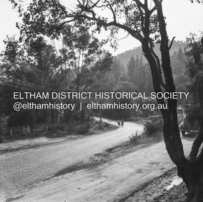 Eltham District Historical Society Inc
Negative - Photograph, J.A. McDonald, Heidelberg-Kinglake Road, 11 May 1961
Silvan Road Bridge Looking northwards before reconstruction View centreline to left of old bridge site 11 May 1961Record of various Shire of Eltham infrastructure works undertaken during the period of 1952-1962 involving bridge and road reconstruction projects, sometimes with Eltham Shire Council Project Reference numbers quoted. It was during this period that a number of significant improvements were made to roads and new bridges constructed within the shire that remain in place as of present day (2022). In many situations, the photos provide a tangible visible record of infrastructure that existed throughout the early days of the Shire. The album was put together by or under the direction of the Shire Engineer, J.A. McDonald.1961-05-11, heidelberg-kinglake road, infrastructure, bridge construction, shire of eltham, reconstruction works, road construction, silvan road bridge -
 Eltham District Historical Society Inc
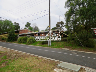
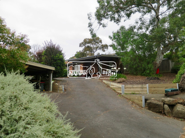
Photograph, Jim Connor, Main Road, Eltham, 14 Jan 2017
Eltham Gateway, Unit complex, 836 Main Road, Eltham at corner of York Street - site of the original old bakehouse and shopTomorrow's history documented todayeltham, jim connor collection, main road, eltham gateway, york street -
 Eltham District Historical Society Inc
Photograph, Jim Connor, Main Road, Eltham, 14 Jan 2017
Eltham Gateway, Unit complex, 836 Main Road, Eltham at corner of York Street - site of the original old bakehouse and shopTomorrow's history documented todayeltham, jim connor collection, main road, eltham gateway, york street -
 Bendigo Military Museum
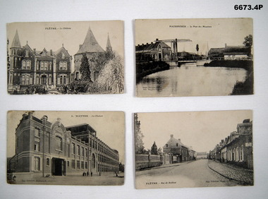
Postcard - POSTCARDS, PHOTOGRAPHIC, C.1914 - 18
Photographs of regional towns in Northern France that were sites of important battles in WW1 and WW2. Both towns are locations of Military Cemeteries.1. B & W photo of French Chateau in Fletre, Flanders, France. 2. B & W photo of Hazebrouck- Le Pont De Meuniers. A waterway in Northern France. 3. B & W photo of Hazebrouck - Watten- La Filature Carts Theatre in Northern France. 4. B & W photo of Fletre - Rue De Bailleul - Street of town in Northern France.1. Headed Fletre - La Chateau. 2. Headed Hazebrouck - Le Pont Des Meuniers. 3. Headed 3. Watten - La Filature. At bottom Imp. Gobrecht Hazebrouck. 4. Bottom - Fletre - Rue De Baillel and Imp Gobrecht Hazebrouck.passchendaele barracks trust, postcards, flanders -
 Greensborough Historical Society
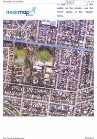
Photograph, Nearmap.com, Nearmap: Greensborough, 27/09/2012
Aerial photographs of the Watsonia area, land owned by Black and Families, including sites of Loyola College, Loyola Reserve and Gresswell ReserveFour coloured aerial photographswatsonia, black family, loyola college, gresswell forest reserve -
 Greensborough Historical Society
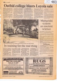
Newspaper Clipping, Diamond Valley News, Outbid college blasts Loyola sale, and, Panel backs shire on Loyola, 07/09/1994
These articles detail the changes to planning regulations around the Loyola seminary site and its sale by the state government to the Maharishi organisation in 1994.These articles show the community interest in the Loyola site and its buildings and form part of the ongoing history of this site.2 newspaper articles. Text only.loyola college, loyola seminary watsonia, ignatian, maharishi -
 Greensborough Historical Society
Newspaper clipping, Diamond Valley Leader, Nurturing creativity, 17/12/1996
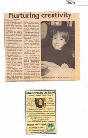
The Maharishi School was due to open in Bundoora in February 1997. This school was on the Loyola College site before Loyola acquired the building and land.Promotional article with photograph (17 December 1996), and advertisement (10 December 1996)transcendental meditation, maharishi school bundoora, loyola college -
![Photograph - Digital image, Marilyn Smith, Mont Park: Central Block [tiled verandah], 30/07/2017](/media/collectors/4f729f5697f83e03086015b8/items/5a0ff00421ea67165ce8f630/item-media/5a0ff03f21ea67165ce912cc/item-fit-380x285.jpg) Greensborough Historical Society
Greensborough Historical SocietyPhotograph - Digital image, Marilyn Smith, Mont Park: Central Block [tiled verandah], 30/07/2017
Mont Park: Central Block - tiled verandah / walkway. Part of a collection of photographs of the original buildings at the Mont Park Hospital site. Digital copy of colour photographmont park hospital -
![Photograph - Digital image, Marilyn Smith, Mont Park: Central Block [garden], 30/07/2017](/media/collectors/4f729f5697f83e03086015b8/items/5a0ff18921ea67165ce9ad52/item-media/5a0ff1ae21ea67165ce9b6f8/item-fit-380x285.jpg) Greensborough Historical Society
Greensborough Historical SocietyPhotograph - Digital image, Marilyn Smith, Mont Park: Central Block [garden], 30/07/2017
Mont Park: Central Block - buildings in their garden setting. Part of a collection of photographs of the original buildings at the Mont Park Hospital site. Digital copy of 2 colour photographsmont park hospital -
 Greensborough Historical Society
Newspaper clipping, Miner killed and rescue effort, 17/12/1936
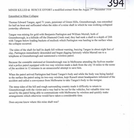
Describes the mine collapse that killed Thomas Edward Tangee of Green Hills, Greensborough, in 1936. The site of this mine is unknown in the 21st century.Includes information about the part-time police presence in Greensborough.One page article modified from the Argus 17th December 1936.mine collapse, thomas edward tangee, greenhills, greensborough, police -
 Eltham District Historical Society Inc
Photograph, Hurstbridge. Beside Railway Station, 1916
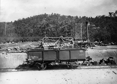
Empty railway truck or wagon on line at Hursbridge parked alongside a site with workmen cutting logs with a circular saw in a rural setting. This photo forms part of a collection of photographs gathered by the Shire of Eltham for their centenary project book, "Pioneers and Painters: 100 years of the Shire of Eltham" by Alan Marshall (1971). The collection of over 500 images is held in partnership between Eltham District Historical Society and Yarra Plenty Regional Library (Eltham Library) and is now formally known as 'The Shire of Eltham Pioneers Photograph Collection.' It is significant in being the first community sourced collection representing the places and people of the Shire's first one hundred years.Digital imagesepp, shire of eltham pioneers photograph collection, hurstbridge, railway truck, railroad, railroad car, sawmills -
Port Melbourne Historical & Preservation Society
Photograph - Prize winning entry, Sugar Shed competition, Elizabeth Rodda, May 1999
May 1999 Sugar Shed photographic competition was held in conjunction with John Sheridan, developer of the site, who donated the $200 prizePrize winning photograph from the 1999 Sugar Shed competition, attached to black paper frame. Titled 'Street Corner' by Elizabeth Rodda. Colour digital print of Rouse and Johnston Street sign (second prize)Title taped on backbuilt environment - domestic, built environment - industrial, elizabeth rodda -
Port Melbourne Historical & Preservation Society
Photograph - Prize winning entry, Sugar Shed competition, Rob Faulkner, May 1999
May 1999 Sugar Shed photographic competition was held in conjunction with John Sheridan, developer of the site, who donated the $200 prizePrize winning photograph from the 1999 Sugar Shed competition, attached to black paper frame. Titled 'Old Sugar Shed 8.15am Winter' by Rob Faulkner. Black and white print of shed, man and dog. (First prize)Title taped on backbuilt environment - domestic, built environment - industrial, rob faulkner -
Port Melbourne Historical & Preservation Society
Photograph - Princes Street, Port Melbourne, Ron Laing, 1999
Ron Laing at the request of the Society photographed the same view as item 799.01 in 1999, prior to the Borer's Bakery site being redevelopedColour photograph taken of Princes Street from the same viewpoint as 1933 photograph of construction workers in the excavation for the main drain in Princes Street (799.01 & .02).built environment, ron laing -
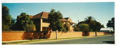 Tatura Irrigation & Wartime Camps Museum
Photograph, Convent of Mercy Tatura
Shows site of old Sacred Heart School, corner of Frances and Casey Streets, Tatura. Shows back of St Mary's and Convent.Colour photograph showing Convent of Mercy, Hogan Street, Tatura. Photograph stuck onto piece of white cardboard. hogan street tatura, convent of mercy tatura, catholic convent tatura -
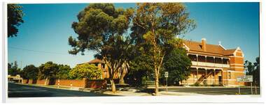 Tatura Irrigation & Wartime Camps Museum
Photograph, Convent of Mercy Tatura
Shows site of old Sacred Heart School, corner of Frances and Casey Streets, Tatura. Shows back of St Mary's and Convent.Colour photograph showing Convent of Mercy, St Mary's church and school car park, Hogan Street, Tatura. Photograph stuck onto piece of white cardboard. hogan street tatura, convent of mercy tatura, catholic convent tatura