Showing 3609 items
matching street map
-
 Bendigo Historical Society Inc.
Slide - DIGGERS & MINING. DIGGERS AND MINERS, c1850s
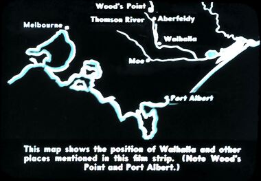
Diggers & Mining. Diggers and miners. Walhalla - Gold Town. This map shows the position of Walhalla and other places mentioned in this film strip. (Note Wood's Point and Port Albert.) Markings: 6 995 WAL. Used as a teaching aid.hanimounteducation, tertiary, goldfields -
 Bendigo Historical Society Inc.
Slide - DIGGERS & MINING. DIGGERS AND MINERS, c1850s
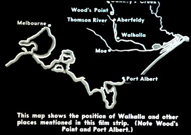
Diggers & Mining. Diggers and miners. Walhalla - Gold Town. This map shows the position of Walhalla and other places mentioned in this film strip. (Note Wood's Point and Port Albert.) Other places on map; Melbourne, Moe, Thomson River, Aberfeldy. Markings: 5 995 WAL. Used as a teaching aid.hanimounteducation, tertiary, goldfields -
 Bendigo Historical Society Inc.
Document - IAN DYETT COLLECTION: AUCTION CATALOGUE - LAKE BELLFIELD PROJECT
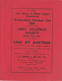
Two copies of red covered auction catalogue for sale on account of State Rivers & Water Supply Commission held on 12/10/1966 Lake Bellfield Project, Hall Gap, Vic. Lots include motor vehicles, corr. Iron & timber buildings, machinery, tools, equipment, stores, scrap iron & steel and furniture. J. H. Curnow & son Pty. Ltd. Were the auctioneers. Catalogue has a map from Melbourne & Geelong to site near Hall's Gap and an Auction Layout sketch.business, auctioneers, j h curnow & son pty ltd, ian dyett collection - auction catalogue - lake bellfield project, state rivers & water supply commission, j h curnow & son pty ltd, f c dyett, l c osborne, c hill -
 Bendigo Historical Society Inc.
Document - IAN DYETT COLLECTION: AUCTION CATALOGUE - VIC ROADS
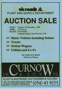
Light blue covered auction catalogue with black printing for a sale on 5th December, 1989 at Vic Roads, Glen Waverley. For sale were Motor Vehicles including Sedans, Trucks, Station Wagons, Utilities and 4 x 4's. J. H. Curnow & Son P/L were the auctioneers. Back cover has a map locality and a locality map of the auction area.business, auctioneers, j h curnow & son pty ltd, ian dyett collection - auction catalogue - vic roads plant and supply department, j h curnow & son p/l, bolton bros pty ltd -
 Bendigo Historical Society Inc.
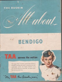
Booklet - Tourist guide, 1956
The Ruskin All-About Bendigo Booklet produced for the 1956 Melbourne Olympics. Includes maps and facts, service organizations and businesses in Bendigo. Includes advertisements for Australian companies. TAA on the cover. Produced by Ruskin Publishing Pty Ltd 37 Swanston St. Melbourne.advertising, services, bendigo businesses, bendigo maps -
 Bendigo Historical Society Inc.
Flyer - Eaglehawk Heritage Society leaflets
Trifold leaflet black print on blue paper, includes map of the Borough and "places of Interest". Includes history of the house "Caradon".historic points of interest within eaglehawk, map of points of historic interest within eaglehawk -
 Bendigo Historical Society Inc.
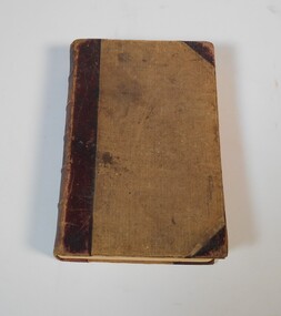
Book - Geographical dictionary
The Gazetteer presents an extensive a to z list of Victorian towns and villages, lakes, rivers and creeks, islands, bays, hills and mountains, runs and other localities and features. Entries include latitude and longitude, populations, proximity to other towns, local industries, coach and mail runs, hotels, churches and schools.Bailliere's Victorian Gazetteer and road guide containing the most recent and accurate information as to every place in the colony. Brown hardcover book, on the spine: Victorian Gazetteer with map 1865. The first and last pages are advertisements. The book has 442 pages listing every place in the colony. The map is not included. Compiled by Robert P. Whitworth. Published by Bailliere, Regent Street Unreadable name on first page and the name of F. Houston in blue pen on first page geographic dictionary, colony of victoria -
 Bendigo Historical Society Inc.
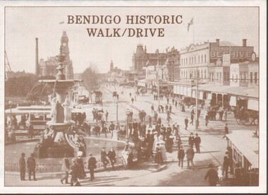
Flyer - Bendigo Historic Walk / Drive
1988 Bendigo Historic Walk / Drive pamphlet. A3 quarter folded to show map of Bendigo and walking tour options to visit local buildings. Dual print in two colours (orange and brown) includes several images.walking tour, driving tour -
 Bendigo Historical Society Inc.
Document - Chinese Distribution in Eaglehawk and Sandhurst in 1861
Chinese Distribution in Eaglehawk and Sandhurst in 1861. Sketch and Map of the Chinese showing their population based on the census.history, bendigo, eaglehawk, chinese, sandhurst -
 Bendigo Historical Society Inc.
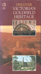
Book - Discover Victoria's Goldfield Heritage
128-page illustrated soft cover book entitled 'Discover Victoria's Goldfield Heritage. Includes Ballarat, Bendigo, Castlemaine and Stawell Written by Douglas Stone and Greg Dunnett First published 1993 by See Australia Guides Pty Ltd Printed and bound by Toppan, Hong Kong Includes route maps, city and town maps, town walks, scenic drives and bike rides.Handwritten in pen PETER RYALL on title page.goldfields, bendigo, ballarat, castlemaine, see australia guides -
 Bendigo Historical Society Inc.
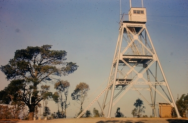
Slide - Peter Ellis Collection, Kaweka Wildflower Reserve, Castlemaine, Lightning Hill Lookout Bendigo, One Tree Hill Lookout Tower Bendigo, Kamarooka Forest Area, c1970-1972
Kaweka Reserve is a a small reserve of approximately 8ha. The land was donated to the Castlemaine City to be a wildflower Reserve. A management committee was formed in 1966. The committee is still managing the park. Vicroads Edition 6: Map 59E2, 628 H4 Location. Turner St, Castlemaine. From the Castlemaine Post Office, drive north (towards Bendigo) and turn right along Turner Street to the park entrance. What to do: walk along some of the tracks through the park follow the nature trail bird watch have a picnic at the picnic tables. RUSH Dam is a basic free camping area sits alongside Rush Dam in the Greater Bendigo National Park, featuring a single picnic table and wood fire barbecue.Peter Ellis Collection: Seventeen slides of Kaweka Wildflower Reserve, Castlemaine, Lightning Hill Lookout Bendigo, One Tree Hill Lookout Tower Bendigo. Also the Rush Dam free camping area at Kamarooka. Also a slide of an unknown group having a meal or day out; perhaps also a working bee. In addition there are two slides of a house - location not specified; and a working bee clearing along a pipeline at Big Hill. Peter was a chemistry lecturer at the Bendigo Institute of technology.history, bendigo, peter ellis collection, whipstick bendigo, bendigo state forests, kaweka wildflower reserve castlemaine, one tree hill lookout bendigo, lightning hill lookout bendigo, kamarooka, rush dam kamarooka, greater bendigo national park -
 Kyneton RSL Sub Branch
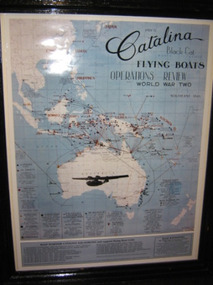
Framed map, Catalina Flying Boats
Map of Australia showing .... Catalina Flying Boats Operations Review World War Two. -
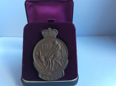 Kyneton RSL Sub Branch
Medallion, ANZAC Commemorative Medallion, 1967
The Anzac Commemorative Medallion was issued in 1967. It was awarded to surviving members ( or next of kin) of the Australian Forces who served on the Gallipoli Peninsular from April 1915 - Jan 1916.Round medallion with crown on top. Impressions both sides. Is contained in a black case lined with purple fabric.Front: 1915 ANZAC Two soldiers on a donkey.. Back: Relief map of Australia and New Zealand. and five stars of the Southern Cross. F.J. Roberts.anzac, gallipoli, commemorative medallion -
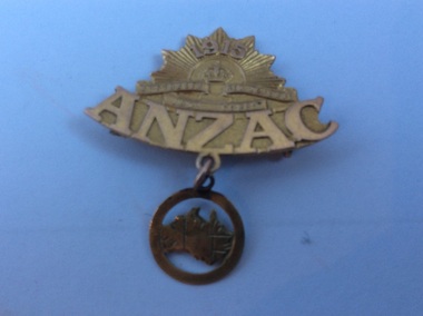 Kyneton RSL Sub Branch
Brooch, Sweetheart Brooch
Brooch designed in style of rising sun badge, with smaller pendant attached depicting map of Australia. Clip on back is broken.Front: 1915 ANZAC Back small jewellers marks -
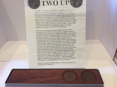 Kyneton RSL Sub Branch
Two -Up
The game of TWO-UP was a popular gambling game played by soldiers during WW1.Piece of timber with two indentations to sit two pennies in side by side. Decoration at one end includes a map of Australia. The board is accompanied by a description of how to play TWO-UP. Two pennies sit in position.two-up -
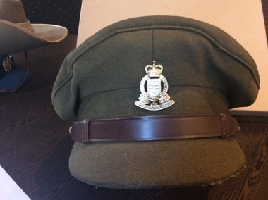 Kyneton RSL Sub Branch
Uniform, Cap
Clothing issue for Royal Australian Army Ordnance Corps.Khaki cap with leather strap above peak held in place with two brass buttons decorated with map of Australia and crown. Badge centre front, shield topped with crown. Leather band insert.Top of inside of cap is clear plastic lined.On badge. Australian Army Ordnance with Royal & Corps above. On the wreath surrounding shield, latin motto inscribed. Inside red label TATHAN. Brand label EMERCO in crown of hat.army cap -
 Bendigo Historical Society Inc.
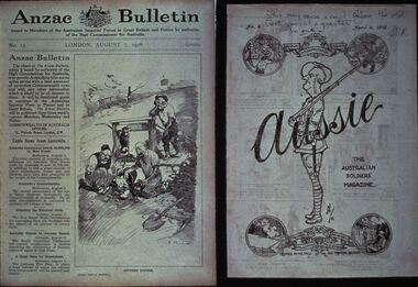
Slide - DIGGERS & MINING: THE DIGGERS, c1918
Diggers & Mining: The Diggers. Slide of ANZAC BULLETIN, London August 7, 1916 (on left of slide). Ride side of slide is the back cover of a Bulletin dated April 4, 1918 with artwork on it, main section has a soldier with the word Aussie across it, the head of the soldier is the map of Australia the wording 'The Australian Soldiers' Magazine' along side the soldier. Markings by hand: This may ease a smile be\fore the bell goes at quarter to one SCR. Dated April 4, 1918. Markings: VISAR COPYRIGHT SET - THE DIGGERS, 13. Used as a teaching aid.Visaireducation, tertiary, war -
 Bendigo Historical Society Inc.
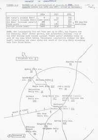
Document - PETER ELLIS COLLECTION: A GUIDE FOR DRIVERS ON THE WHIPSTICK TOUR
A Guide for Drivers on the Whipstick Tour. First page gives assembly area, driving in convoy and negotiating water or boggy patches across the road. Amended written at the end of the page. Directions with mileage and items of interest for the tour on Sunday September 9th (no year). A Whipstick Map 1971 showing State Forest, Crown Lands, Uncleared Mallee - Private (shown in different colours) Water Reserve and Roads. Noted are Flora and Fauna - Plants, Birds & Mammals, and areas of State Forest and Southern State Forest with Mallee Scrub area noted. Also State Forest & Crown Lands Total Area and a map scale. The Bendigo Whipstick mentions area, suggestions of where the name Whipstick came from, shrubs and flowers with their flowering times, descriptions of some of them and some information on the Mallee Fowl. The Eucalyptus Oil Industry paragraph mentions the beginnings of the industry. Mentioned are the different uses of oils (perfumery, industrial and medicinal) and the different species of eucalypt used for each and various products. Also notes on the growing, harvesting and refining of eucalyptus. P Ellis at the end of the page. The next two and a half pages mentions reserves, and at the end acknowledgements. Includes a spare copy of 'The Bendigo Whipstick' by P Ellis.bendigo, history, early bendigo, peter ellis collection, a guide for drivers on the whipstick tour, the whipstick 1971 map, shire of marong, shire of east loddon, shire of huntly, borough of eaglehawk, city of bendigo, shire of strathfieldsaye, the bendigo whipstick, eucalyptus oil industry, eaglehawk town hall, lightning hill lookout, eaglehawk rifle range, new moon mines, blue jacket reservoir, maggetti's wine hall, camp hotel (ex), skylark dam, eucalyptus oil production, eucalyptus factory, whipstick eucalyptus farm, ruedin's eucalyptus factory, dutch bowls, governor philip, sir joseph banks, john white, baron von mueller, joseph bosisto, commonwealth government, perfumery oils, industrial oils, medicinal oils, p ellis, dr frith, csiro wildlife division, harley webster, forests commission, vincent serventy, victorian national parks association, bendigo field naturalists club -
 Bendigo Historical Society Inc.
Souvenir - FEDERATION STICK PIN, 1901
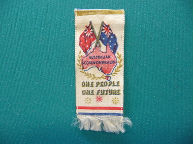
Federation Stick pin with ribbon of white satin with map of Australia underneath Australian & Red Ensign flags, worded Australian Commonwealth One People One Future, fringed on bottom.event, official, federation -
 Bendigo Historical Society Inc.
Document - PETER ELLIS COLLECTION: BUSH DANCE AND MUSIC CLUB BENDIGO, September
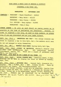
Three Bush Dance & Music Club of Bendigo & District Newsletters, Sept 1989 (yellow), October 1989 (green) and December 1989 (yellow). Newsletters contain contacts, Coming Events, dance programs and September 1989 edition has a map of how to get to the Notley's Picnic area. Also reports and in the October edition a sketch of how to get to a picnic area in the Wellsford Forest. The December issue has the contacts, Christmas Break-up and next meeting. On the back is the monthly dance dates for 1990.clubs, music, bush dance & music club of bendigo, peter ellis collection, bush dance & music club of bendigo & district, wayne blandford, mary smith, gary clancy, marg lapham, notley's reserve, reservoir hotel, wedderburn old timers, harry mcqueen & friends, lorraine ogilvie, mike jackson, val wilson, barry simpson, peter ellis, victorian folk music club, shirley andrews, john meredith -
 Bendigo Historical Society Inc.
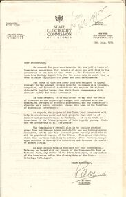
Document - MERLE BUSH COLLECTION: VARIOUS DOCS
Various docs (possibly from Bush Collection?) a. Public issue of State Electricity Commission securities - letter to Stockholders; Power Loans ; Cash and Conversion Loans 1954/55; b. Board of Works Cash Loan Prospectus 1956; c. Card with information re the MMBW Metropolitan Farm; d. two B&W interior photos of St. Davids church, Hobart; e. J C Williamson Magazine programme 1934; f. Melbourne & Metropolitan Tramways Board -map of proposals for General Scheme 1923.ephemera, mementoes, general interest -
 Bendigo Historical Society Inc.
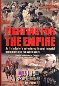
Book - FIGHTING FOR THE EMPIRE
Fighting for the Empire, an Irish doctor's adventures through imperial campaigns and two world wars, the life and times of Thomas Bernard Kelly 1870-1949. Hard cover with dust jacket published by Sabrestorm, 240 pages with colour and black & white photographs and maps. Chapter 2 relates to Bendigo through Michael an older brother.David Worsfoldbooks, biography, kelly -
 Bendigo Historical Society Inc.
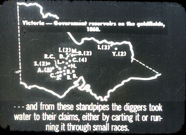
Slide - DIGGERS & MINING. GETTING THE GOLD, c1860
Diggers & Mining. Getting the Gold. Slide: Map of Victoria. Victoria - Government reservoirs on the goldfields, 1860. Letters on map relate to the position of the reservoirs standpipes. And from these standpipes the diggers took water to their claims, either by carting it or running it through small races. Markings: 72 994.LIF:4. Used as a teaching aid.hanimounteducation, tertiary, goldfields -
 Bendigo Historical Society Inc.
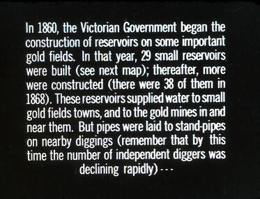
Slide - DIGGERS & MINING. GETTING THE GOLD, c1860
Diggers & Mining. Getting the Gold. Slide: In 1860, the Victorian Government began the construction of Reservoirs on some important gold fields. In that year, 29 small reservoirs were built (see next map); thereafter, more were constructed (there were 38 of them in 1868). These reservoirs supplied water to small gold fields towns, and to the gold mines in and near them. But pipes were laid to stand-pipes on nearby diggings (remember that by this time the number of independent diggers was declining rapidly) Markings: 71 994.LIF:4. Used as a teaching aid.hanimounteducation, tertiary, goldfields -
 Bendigo Historical Society Inc.
Map - BENDIGO, GREATER CITY OF, 2013
Map, City of Greater Bendigo, Epsom/Huntly, Heathcote, Strathfieldsaye/ Junortoun, Mandurang, Sebastian, Mia Mia, Maiden Gully, Ravenswoon, Axedale, Myers Flat, Redesdale, September 2013, on front. Lockwood South, Marong, Raywood, Neilborough, Elmore, Goornong, on reverse side. ( number 413 in Map Cupboard 1 ). Donated by Bendigo Council.bendigo, hospital -
Bendigo Historical Society Inc.
Map - PANNOOMILLOO : COUNTY OF BENDIGO, 1957
Map. Pannoomilloo, County of Bendigo, Pannoobamawm, Milloo, Warragamba, Diggorra, Property Allotments. Drawn and Reproduced at the Department of Lands and Survey,1957. Price 2/-. (number 412 in Map Cupboard 1 ).W.M. Houston, Government Printer, Melbourne.bendigo, hospital -
Bendigo Historical Society Inc.
Map - WANURP: COUNTY OF BENDIGO, 1/12/33
Map. Wanurp, County of Bendigo, Terrick Terrick East, Mitiamo, Dingee, Milloo, Pannoobamawm. L422+. Photo-Lithographed at the Department of Lands and Survey, Melbourne, Price 2/-. 1/12/33 ( number 411 in Map Cupboard 1 )H.J. Green, Government Printerbendigo, hospital -
Bendigo Historical Society Inc.
Map - PANNOOBAMAWM : COUNTY OF BENDIGO, 1957
Map. Pannoobamawm, County of Bendigo, Terrick Terrick East, Wanurp, Pannoomilloo, Bamawm, Turrumberry, property allotments. Drawn and reproduced at the Department of Lands and Survey, 1957, Price 2/-. (number 410 in Map Cupboard 1 ).W.M. Houston, Government Printer, Melbourne.bendigo, hospital -
Bendigo Historical Society Inc.
Map - NERRING : COUNTY OF BENDIGO, August 1952
Map. Nerring, County of Bendigo, Leichardt, Marong, Sandhurst, Huntly, Neilborough, Yarraberb. Drawn and Reproduced at the Department of Lands and Survey, Melbourne, Victoria, August 1952, Price 2/-.( number 409 in Map Cupboard 1).J.J. Gourley, Government Printer, Melbourne.bendigo, hospital -
Bendigo Historical Society Inc.
Map - BENDIGO GOLD FIELDS
Map, Bendigo Gold Fields, copy, mining leases, the numbers of their leases, as well as streets of Bendigo.( number 408 in Map Cupboard 1).bendigo, mining, mining leases