Showing 22494 items matching "will park"
-
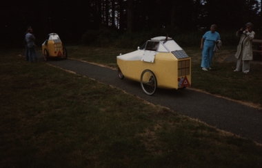 Federation University Historical Collection
Photograph - Colour, Chatham-Holmes Collection: Solar-powered cars
Two yellow solar-powered cars on path in a parkchatham-holmes collection, solar, solar-powered, cars -
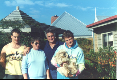 Lakes Entrance Historical Society
Photograph, Margaret, Robert and Scott Carpenter, 1/06/1989 12:00:00 AM
taken at Carpenters Camp Park Lakes Entrance VictoriaColour photograph of Lionel Carpenters wife Margaret and sons Robert and Scott Lakes Entrance Victoriagenealogy, historic buildings, pioneers -
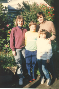 Lakes Entrance Historical Society
Photograph, Gaye and Anthony Pitt /Carpenter, 1/06/1989 12:00:00 AM
taken at Carpenters Camp Park Lakes Entrance VictoriaColour photograph of Anthony Pitt with wife Gaye nee Carpenter children Greg and Melanie genealogy, carpenter family -
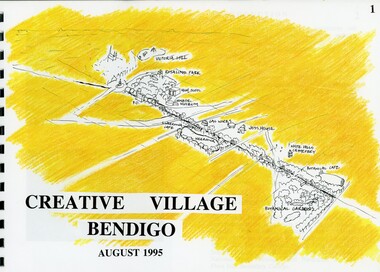 Bendigo Historical Society Inc.
Book - MERLE HALL COLLECTION: ROSALIND PARK CREATIVE VILLAGE BENDIGO PROJECT BOOK, 1995
Merle Hall Collection: Rosalind Park Creative Village Bendigo Project Book. August 1995 Book contains a description, aims of the programme and a linking plan. 35 Pages: Cover Intoduction, The Design Team, Acknowledgement Project Brief Map of Linked Park The Linking Plan described Linking plan graphic Golden Beacon Design Concept Bridge Beacon Entrance to Linear Park Gasworks Café Pavillion Gasworks layout plan Golden Beacons Concept Botanical Gardens Café Botanical Gardens layout plan Victoria Hill Interpretation Centre Victoria Hill layout Victoria Hill plan Victoria Hill continued Victoria Hill continued Rosalind Park Lookout Method 3D Road Map 3D Road Map Continued Implementation Community Participation Oppurtunities, Mosaic Works Appropriate sites Appropriate sites continued Consultaion Summary and Issues Ideas Areas for further consideration Graphic The Design Team - Grant Fink, Jane Marriott, Laszo Biro, James Brearley Graphic Layoutbook -
 Tatura Irrigation & Wartime Camps Museum
Photographs, Alexander Stewart who lived at Gowrie Park
GOWRIE PARK- Gowrie Park Road, Tatura.|Alexander and Georgina Stewart sailed in 1859 from Mochrum, Scotland, arriving in Corio Bay. In 1872-73 they came to Tatura and selected near the town, being one of the early selectors. The place was called Gowrie Park, still known by that name, and still in use as a dairy farm.|Before the Presbyterian Church was built in Tatura, all the services were held at Gowrie Park. The old dairy for keeping milk, cream and butter is still there today. Only two families have owned the property since the 1870®s, and the house has been beautifully renovated and extended.Photo 1: 15 x 11 cms. Photo 2: 10 x 6 cms. -
 Kew Historical Society Inc
Photograph - Willsmere [Kew] Billabong, 1993
Willsmere Park is bounded by the the Yarra River, Green Acres Golf Club, Willow Grove and the Eastern Freeway. The land on which the park is now situated was bought by Thomas Wills at the Crown Land Sales of 1846 (Section 56). From the 1840s to the 1940s it was intensively farmed. The park is dominated by very large playing fields, while planting to the southern boundary was undertaken when the Eastern Freeway was built. It is only along the banks of the Yarra that there is any remnant native vegetation. Willsmere Park is of significance as an area of open land that remains from the flood plain that once dominated northern Kew. (Source: Kew Conservation Study, 1988)Original colour small format polaroid photograph of Willsmere [Kew] Billabong on September 1993."Willsmere Billabong 16.9.93"yarra river -- floods -- kew (vic.), willsmere park -
 Eltham District Historical Society Inc
Photograph, Russell Yeoman, 66 Susan Street, Eltham, c.1965, 1965c
Sibbel factory in Brisbane Street in centre background running across view. In 1965 the property was owned by the Shire of Eltham. 66 Susan Street was eventually developed into the Eltham Skate Park in the 1990s and the rest of the property is part of the Alistair Knox Park.Digital file only; created from original colour positive slide transparencyeltham, streets, houses, alistair knox park, eltham skate park, herman sibbel, martin sibbel, sibbel factory, susan street, brisbane street, russell yeoman collection -
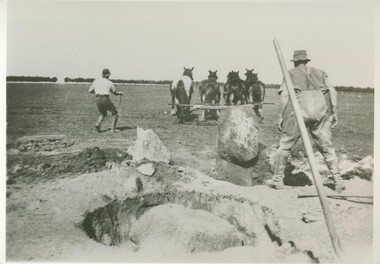 Lake Bolac & District Historical Society
Black and white photograph, Grubbing rocks at "Boswell Park", Lake Bolac
Grubbing rocks at "Boswell Park" Lake Bolac, in order to prepare the ground for ploughing and cropping. Most ground on the Western District volcanic plains had to be prepared in this way before the soil could be tilled. "Boswell Park" was run by the Moreton family.lake bolac, boswell park, grubbing rocks, moreton, cropping -
 Kew Historical Society Inc
Photograph - Alma and Silvia Figuerola, D'Estaville, The Age, c.1965
The Melbourne artist Alma Agnes Marion Figuerola, was the daughter of Juan Pedro Narciso Figuerola (1869-1919) and Alice Lucinda Walker Hanson (1889-1969). Each of their three daughters grew up to be involved in the arts: Alma as a painter; Carmen Irene (1906-1993) as a short story writer, poet and teacher of dancing; and Sylvia (also Silvia) Lyla Alice (1911-1992) as a composer and cellist. The first art lessons Alma Figuerola received were with Oscar Binder. Later she attended the art school established by the Melbourne 'tonalist' [Duncan] Max Meldrum (1875-1955). She graduated from his school in 1920, participating in her first group exhibition in the same year. Solo exhibitions of her work were to be held in 1933 at the Meldrum Gallery in Elizabeth Street, in 1937 and 1945 at the Athenaeum Gallery at 188 Collins Street, and in 1951 at Georges Gallery in Collins Street. Throughout her extensive career she participated in group exhibitions, usually with artists of the Meldrum School, and as a member of the Twenty Melbourne Painters, of which she was invited to become an associate in 1935. In 1953, her portrait of Professor ES Hills was entered in the Archibald Prize Competition of the Art Gallery of New South Wales. A resident of Kew from the 1930s - 51 Studley Park Road, often with her mother, her sister Carmen, or both - from c.1942 until her death she lived at 'D’Estaville', 7 Barry Street. From the late 1930s she is recorded as actively contributing to the arts at a local level. In 1939 and 1940 she participated in art exhibitions at the Hawthorn Municipal Library organised by Jessie Carbines. From 1944 to 1951 she co-organised successive Kew Arts Festivals, initially in the Presbyterian Church Hall in Highbury Grove and later at the Recreation Hall in Wellington Street. A foundation member of the Kew Historical Society in 1958, Alma Figuerola remained an active member of the Society until her death on 8 December 1970. She predeceased her two sisters who both died in the 1990s and who are buried at Andersons' Creek Cemetery in Warrandyte.This photographic is part of a series that is historically and aesthetically significant, in that they record the appearance of an historic Kew mansion in the 1960s, and also its owner, Alma Figuerola, a pupil of Max Meldrum, and a Melbourne artist who lived in Kew.D'Estaville, Barry Street, Kew. The facade facing Barry Street. The original front of the property faced Studley Park Road where the front door is still located. This is a newspaper photograph, part of a series on the artist Alma Figuerola, and is still under copyright. Alma Figuerola was a foundation member of the Kew Historical Society. She died in 1970, so the photograph predates this. Annotation on reverse: "View showing side of mansion there is a wing running from left hand side. / Owner with her sister Silvia and "the Head".alice figuerola, australian artists, d'estaville, 7 barry street -- kew (vic.) -
 Bendigo Historical Society Inc.
Article - MERLE HALL COLLECTION: ROSALIND PARK CREATIVE VILLAGE BENDIGO NEWSPAPER ARTICLES, 1997
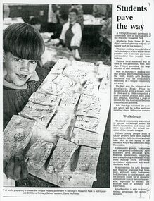
MERLE HALL COLLECTION: ROSALIND PARK CREATIVE VILLAGE BENDIGO NEWSPAPER ARTICLES 3858.9a Young boy holding a board of mosaic tiles probably at a workshop. Article begins: A unique mosaic pavement is to become part of the tapestry of the restored Rosalind Park. Students from three of Bendigo's central primary schools are taking part in the project. Photo Caption reads ART at work: preparing to create the unique mosaic pavement in Bendigo's Rosaling Park is eight year old St Killians Primary School student, David Nicholds. 3858.9b A newspaper coloured photo from the poppet head of two young people standing on and looking down on the mosaic at the lookout. Caption reads: Passing students take a keen interest in the new-look base of the Rosaling Park poppet head. The mosaic was created through an Art Bendigo project. LEAP workers helped install the five sections using stone tiles made by local primary school students. Depicting the saddle reef formations in the area the work has been designed and created by Bendigo artise Maery Hall. Picture: Peter Hyett. 3858.9c A photo from the poppet head lookout looking down at a worker with a broom, sweeping the mosaic. 3858.9d Two women crouching on the ground viewing the work done on the mosaic. One woman holds books and papers; in the far background over the car-park is the Sacred Heart Cathedral, the Bendigo Art Gallery and the Capital Theatre. 3858.9e Newspaper article along with coloured photo of the poppet head lookout in Bendigo's Rosalind Park. In the foreground are two young people arranging the mosaics. The article begins: Mosaic pavements began taking shape at the base of the Rosaling Park poppet head lookout yesterday. The pavement will cover about 130 square metres, in five sections, and have been designed as a memorial to Bendigo's mining history and traditions. 3858.9f Newspaper article July 29, 1997 entitled 'Bendigo Paving the Way' - photo of artist Maery Gabriel at the official opening of the heritage mosaic. Pictures: Tania Bond. Photo of Maery taken from the poppet head looking down on the mosaic. Als a smaller photo with details of the mosaic design. Opening paragraphs of the artical: Arts Bendigo and the City of Greater Bendigo are paving the way to an improved Rosalind Park with the official opening of the 'Bendigo Heritage Mosaic'. The mosaic is more than 100 square metres of decorated pavement sections surrounding the poppet head lookout at the park. The paving was designed by mosaic artist Mary Gabriel and depicts Bendigo's mining history and colour throughout. -
 Southern Sherbrooke Historical Society Inc.
Information folder - Glen Park
Folder containing information pertaining to the history of Glen Park homestead, Menzies Creek. Contents: -two pages photocopied from "That Little Train" by Peter Cuffley, showing four photos of Glen Park homestead and a short history of Edwin Johns at Glen Park (2 copies of each) -articles, "No. 861's full steam ahead again", photo shows Col Rees with Coonara Community School students, and "Living the dream" re. engine no. 861. On verso, "A Family Reunited", article by Emerald Tourist Railway re. locomotives, and "Colin just loves steam locomotion" re. engine no. 861. -4 letters, from Puffing Billy Railway, in support of Col Rees. -Letter, dated 19 June 1996, from Emerald Tourist Railway, re. appeal for restoration of Garratt engine. On verso, copy of certificate awarded to Col Rees for donation to appeal. -Letter, 1 June 1998, re. Garrett appeal. On verso, certificate awarded to Col & Kellie Rees for donation to appeal. -Aerial photo showing proposed property boundaries of Glen Park subdivision. -Aerial photo showing existing property boundaries of Glen Park. NB. last four items provided to society by Col Rees in support of subdivision. -Memorandum dated 2 May 2000 from Graham Whitt, Shire of Yarra Ranges, to Shire Service Centres, re proposed division of Glen Park land. -Fax, dated 13 June 2000, from Southern Sherbrooke Historical Society to Shire of Yarra Ranges, re. intention to make submission. -Letter, dated 14 June 2000, acknowledging receipt of above fax. -Submission, dated 18 June 2000, from Southern Sherbrooke HS, expressing concern re. proposed subdivision of Glen Park. -Fax, dated 27 June 2000, from Dianne Kueffer to Susan Heywood-Downard, Agenda Item 2 of the Yarra Ranges Planning Committee Agenda 14 March 2000, including detailed description of proposed subdivision and map. -Letter, dated 7 July 2000, Shire to Society, re. discussion of Glen Park subdivision by council. -Letter, dated 7 July 2000, Society to Shire, re. withdrawal of objection subject to certain conditions. -Letter, dated 14 July 2000, Shire to Society, re. council resolution to allow subdivision of Glen Park. -Letter, dated 24 October 2000, Shire to Society, stating that amendment to Planning Scheme allowing subdivision was approved by council and gazetted on 19 October 2000. -seven A3 sheets, showing house and property plans for new constructions proposed for Lot 1 of Glen Park subdivision. -diagram, hand-drawn (by Col Rees?) on lined A4 sheet, showing proposed development. -A1 sheet, Plan of feature survey of Lot 2 Blackhill Rd, Selby, dated 12 April 2000, showing contours, vegetation, proposed location of buildings, etc. -Glen Park Homestead and Cyprus Avenue, document prepared for the Shire Of Yarra Ranges by Helen Lardner Conservation & Design P/L, June 2003edwin johns, breen family, col & kellie rees, puffing billy -
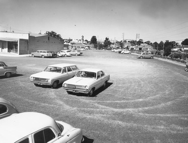
 Ringwood and District Historical Society
Photograph, Photos of last houses to face demolition at Camberwell. c1970s, c1983
One of the last houses to face demolition.Single fronted weatherboard with striped veranda blind, brick chimney over front rooms with TV aerial. Green painted walls. Red painted iron roof over veranda and under veranda rail. Adjacent to Target entrance.The 'Miss Stayput' house in the car park out the front of Target in Camberwell. You can even see the Target logo on the building. The house was owned by Mary Campigli, who defied the council order to move, and won her case in court. She stayed in the house, surrounded by a car park until she died in 1983 at the age of 94. The house was finally demolished soon after. -
 Ringwood and District Historical Society
Photograph, Car park at rear of Ringwood Shopping Centre (undated)
Written on back of photograph, "Parking back of Murray Place. E. Post. John Gallagher photography." Catalogue card reads, "Car park at rear of Ringwood Shopping Centre." -
 Ringwood and District Historical Society
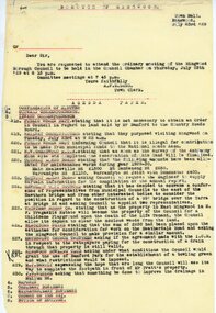
Document, From Borough of Ringwood Council, agenda for next council meeting on 23 July 1929
1929 saw the establishment of the Ringwood Bowls Club initially located on the land now occupied by the Eastland Shopping Centre. It moved to its current location in Loughnan Road, Ringwood in 1997.From Borough of Ringwood Council, agenda for next council meeting on 23 July 1929. Ringwood Bowling Club requesting conditions for use of Bamford Park as a bowling green.city of ringwood bowls club, ringwood bowling club, ringwood bowls club, lawn bowls, bowling -
 Clunes Museum
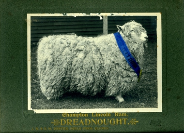
Photograph
PHOTOGRAPH OF A CHAMPION LINCOLN RAM - "DREADNOUGHT" IN GOLD LETTERING ON THE CARDBOARD MOUNT: CHAMPION LINCOLN RAM "DREADNOUGHT" J.R. AND A.W. CARTER "SCALE PARK" CLUNES ON THE RIBBON AROUND THE NECK OF THE RAM: "BALLARAT A P & S"local history, photography, photographs, carter family -
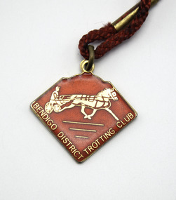
 Victorian Harness Racing Heritage Collection at Lord's Raceway Bendigo
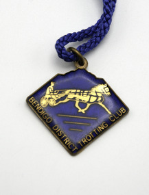
Badge - Membership, Bendigo District Trotting Club, Season 1980/81
Season 1980/81 Bendigo District Trotting Club Membership BadgeEnamelled Blue Badge attached to length of Blue CordFront: Imprint of horse, sulky, driver / Bendigo District Trotting Club. Back: Not Transferable / Season 1980-81 / Ends 31st July 1981 / 030 / AJ Parkes.bhrc, bendigo harness racing club, harness racing, trotting, badge, membership, 1980/81 -
 Victorian Harness Racing Heritage Collection at Lord's Raceway Bendigo
Badge - Membership, Bendigo District Trotting Club, Season 1979/80
Season 1979/80 Bendigo District Trotting Club Membership BadgeEnamelled Red Badge attached to length of Red CordFront: Imprint of horse, sulky, driver / Bendigo District Trotting Club. Back: Not Transferable / Season 1979-80 / Ends 31st July 1980 / 013 / AJ Parkes.bhrc, bendigo harness racing club, harness racing, trotting, badge, membership, 1979/80 -
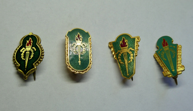 Melbourne Legacy
Badge, Legacy Appeal Badges - £10, 1960s
An example of badges issued by Legacy prior to 1966 for fundraising during the Legacy Appeal and Badge Week. Their donation value was £10. The symbol of Legacy is the Torch and Wreath of Laurel. The Torch signifies the undying flame of service and sacrifice of those who gave their lives for their country. The Wreath of Laurel is the symbol of our remembrance of them. Examples of early Legacy badges that were sold up to raise money for Legacy's work. These were before decimal currency was issued in 1966.Legacy Appeal badges x 4 with the Legacy torch and wreath issued prior to 1966, they are gold metal with dark green enamel and red enamel in the flame.One says 'Denham Neal & Treloar £10' on reverse. One says '£10 D.N.T.' on reverse. Two say '£10 "Parxite 77" AJ Parkes Brisbane' on reverse.legacy appeal, fundraising, badge week -
 Ringwood and District Historical Society
Photograph, Lyell Owen Mackinlay. c1924
Black and white photograph (2 copies- 1 original on cardboard backing, 1 retouched copy)Written on back of original image: "W MacKinlay, c1924". Photographer listed as "Eden Photo Studios, Melbourne". Written on back of copy: "Sandy Ross- Photographer. Chirnside Park". -
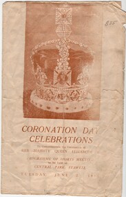 Stawell Historical Society Inc
Book, Stawell Times News, Coronation Day Celebrations, Sports Meeting Program, 1953
A sports day Programme held in celebration of the Coronation of Her Majesty Queen Elizabeth II in 1953Faded paper with B/W photo of a crown. brown printCoronation Day Celebrations To Commemorate the Coronation of Her Majesty Queen Elizabeth II Programme of Sports Meeting to be held at Central Park Stawell Tuesday June 2 1953 stawell sports -
 Darebin Parklands Association
Opening of Rangers Hut 1980, Rockbeare Park Conservation Group et al, 1980
Colour photograph. This item and all other Darebin Parklands Association archival material is now held by State Library Victoria (Accession No: YMS 13746). Please contact State Library Victoria if access is required.Annotated on back [Opening of 1st Ranger's Hut 1980 showing roof of hut below. Rockbeare Park. photograph L. Course] Opened by Rupert Hamer, Premier Victoria. -
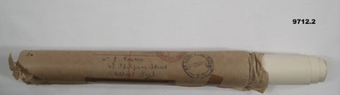 Bendigo Military Museum
Memorabilia - MEMORIAL SCROLL, Australian Army Medal Section, c.1942
Scroll re death of "Thomas Coates", VX18443. Died 5/3/42. Item is part of the Coates Family Collection. Refer 9654.4 for Tom’s service details.White paper scroll rolled up and contained in a brown paper tubal postal container. Container has postal delivery address and return address and various ink stamps. Actual scroll is in very delicate condition so not taken out for inspection of description. 1, Scroll. 2. Postal tube.1. Addressed to "Mr J. Coates, 45 Philipson Street, Albert Park, Vi If not delivered return address "Army Medal Section, Victoria Barracks, Melbourne, Australia” thomas coates, memorial scroll, coates family 1 -
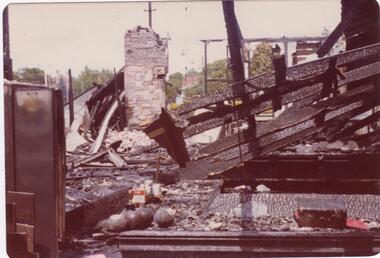 Glen Eira Historical Society
Article - Caulfield Park Bowling Club
This file contains five items. Two original photographs of the remains of Caulfield Park Bowling Club after the fire of 1977, date unknown. An article on the opening of the greens at Caulfield Park Sports Club from the CAULFIELD/ PORT PHILLIP LEADER dated 30/08/2011. An article on a competition that Caulfield Park Sports Club participated in to support the Alcohol Education Rehabilitation Foundation, dated 25/10/2011. An article on the Caulfield Park lawn bowls team being crowned the champions of the Sandbelt region bowls competition and their advancement to the regional playoffs. From the CAULFIELD/ PORT PHILLIP LEADER dated 10/04/2012. An article on the Caulfield Park bowling club ladies team’s win of the 2013 Victorian State Fours Title at Bendigo. GLEN EIRA/ PORT PHILLIP LEADER dated 07/05/2013.caulfield park bowling club, caulfield, caulfield park sports club, entertainment, competitions, aer mixed pairs challenge, alcohol education rehabilitation foundation, mccarthy ann, meltzer sel, sandbelt, pekelman marion, macaulay desiree, victorian state fours title, clubs, associations, organisations, societies, sports, recreations, leisure, cultural events, cultural activities, lawn bowls, sporting clubs, competitions, sports grounds, sports people -
![Painting: Park Street [Adeney Avenue] Kew](/media/collectors/550653872162f11fb04854aa/items/5826877cd0cdd11284ad5413/item-media/614ac683a53a0756fd5e49da/item-fit-380x285.jpg) Kew Historical Society Inc
Kew Historical Society IncPainting, Park Street [Adeney Avenue] Kew, c. 1896
‘Adeney Avenue’ was the title given to this painting following its donation to the Kew Historical Society, yet the work’s origins predate the naming of Adeney Avenue in 1907 [originally gazetted as ‘Park Street’ (1865) and ‘Park Street South’ (1875).] Park Street ran between High Street and Parkhill Road beside what was later to become ‘Victoria Park’. This area was described in 1851 as “…a dense forest of gums and wattles which were to be largely cleared by 1888 after the naming of a recreation reserve”. The Reserve was still bisected by an unnamed creek in 1896, when the area was surveyed by the MMBW. The panoramic vista selected by the artist would appear to include ‘Eborensis’ (c.1895) on the corner of Parkhill Road and what was then Park Street, with views across cleared land towards the distant ranges. In the 19th century, north Kew was largely undeveloped farms stretching down to the Yarra. Oil on canvas by an unidentified artist of a panoramic view depicting what is now known as East Kew with mountains on the horizon. In the foreground is a two storey brick residence - Eborensis - located on the northeast corner of Parkhill Road and what is now Adeney Avenue. The view of the landscape and its rolling hills resulted from farming practices adopted following colonisation and settlement. Trees in the foreground and in the distance include remnant Eucalypts and introduced exotics.Label on rear of frame states "House on corner of Adeney Ave & Parkhill. [Regd. 254"]. Otherwise unsigned and undatedadeney avenue (kew), eborensis, park street (kew) -
 Tatura Irrigation & Wartime Camps Museum
Photograph, Dr. Park's house
Dr. Park's house, now the Tatura Museum.|1888 Rodney Irrigation Trust Office.|1896-1907 Dr. Alexander Park's surgery.|1921- 1938 Dr. James Park's surgery.| - 1982 Home of Mr. & Mrs. James Reilly.|1982-1988 Rented premises.|1988- Bi- Centennial Project- Tatura Museum purchased by Tatura & District Historical Society with financial assistance from Shire of Rodney.|Rodney Shire|Taturaphotograph, people -
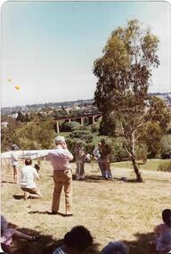
 Eltham District Historical Society Inc
Photograph - Colour Print, Lewis Tulk, Bridge Street, Eltham District Scout Camp, Eltham Town Park, c.1982
View looking southeast from Eltham Town Park (present-day Al;istair Knox Park) across Bridge Street towards the new Eltham Community Centre. Donated by Lewis Tulk, former Scout Area Training Commisioner for Leaders.scouts victoria, scout leader training, lewis tulk collection, yarra batman area, alistair knox park, bridge street, eltham community centre, eltham district scout camp, eltham town park -
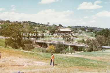
 Eltham District Historical Society Inc
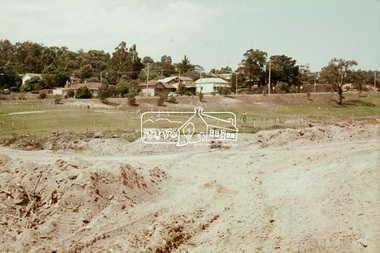
Slide, Construction of Eltham Town Park, 22 Feb 1974
Construction of Eltham Town Park, later renamed Alistair Knox Park. View looking up towards Main Road and the old bakery and feed store on opposite corners of York Street. The feed store is the present site of Le Pine Funerals.35 mm colour positive transparency Mount - Agfacolor Service (Blue)alistair knox park, eltham town park, main road -
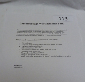 Greensborough Historical Society
Work on paper - Folder of Documents, Ian Bryant, War Memorial Park Greensborough, 2011_
Folder of documents about War Memorial Park Greensborough including aerial photographs and title documents (collected by Ian Bryant) and other information on War Memorial Park bordered by McDowell Street, Ester Street, Henry Street and Vermont Parade Greensborough.Folder of documents - 2 ring binder and A4 printed pages in plastic pockets.greensborough war memorial park, public space, war memorials, ian bryant, parks banyule -
 Eltham District Historical Society Inc
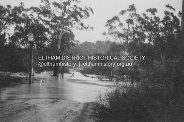
Album - Photograph, J.A. McDonald, Eltham-Diamond Creek Road, 21 Oct. 1953
Floodwaters over Glen Park Bridge 21 October 1953Record of various Shire of Eltham infrastructure works undertaken during the period of 1952-1962 involving bridge and road reconstruction projects, sometimes with Eltham Shire Council Project Reference numbers quoted. It was during this period that a number of significant improvements were made to roads and new bridges constructed within the shire that remain in place as of present day (2022). In many situations, the photos provide a tangible visible record of infrastructure that existed throughout the early days of the Shire. The album was put together by or under the direction of the Shire Engineer, J.A. McDonald.infrastructure, road construction, shire of eltham, 1953-10-21, bridge construction, eltham north, floods, floodwater, glen park bridge -
 Eltham District Historical Society Inc
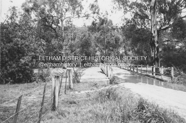
Album - Photograph, J.A. McDonald, Eltham-Diamond Creek Road, 21 Oct. 1953
Floodwaters over Glen Park Bridge 21 October 1953Record of various Shire of Eltham infrastructure works undertaken during the period of 1952-1962 involving bridge and road reconstruction projects, sometimes with Eltham Shire Council Project Reference numbers quoted. It was during this period that a number of significant improvements were made to roads and new bridges constructed within the shire that remain in place as of present day (2022). In many situations, the photos provide a tangible visible record of infrastructure that existed throughout the early days of the Shire. The album was put together by or under the direction of the Shire Engineer, J.A. McDonald.infrastructure, road construction, shire of eltham, 1953-10-21, bridge construction, eltham north, floods, floodwater, glen park bridge