Showing 6702 items
matching river
-
 Ballarat Heritage Services
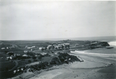
Photograph - Image - Black and White, Port Campbell Coastal Scene, c1925, c1925
Permission to plant the pines was given by the Heytesbury Shire in March 1915. Black and white image of a coastal settlement at Port Campbell. The two storeyed house to the right is Ocean House (built 1918). Next to it is Port Campbell Hotel.coast, beach, river, mouth, port campbell, ocean house, port campbell hotel -
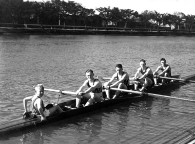 Power House Rowing Club
Black and white photograph, PHRC crew practice 4, 1937, 1937
Digital scan of black and white photograph. Names not recorded.rowers, rowing, row, sports, sportsmen, river, riverbank -
 Bayside Gallery - Bayside City Council Art & Heritage Collection
Painting - oil on canvas board, Barbara Better, Fishing on the Inman, 1977
barbara better, fishing, river, inman, south australia, children, landscape -
 Port Fairy Historical Society Museum and Archives
Photograph
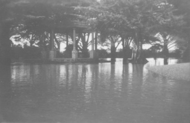
Showing the flood waters of 1946 around the Band Rotunda in the botanical gardens. Funding for the construction of the Rotunda was bequeathed in the Will of local resident Mrs Annie Williams, who was born in Daylesford in 1872 and died in Kew in 1930. Annie’s Will stipulated that the remaining value of her Estate be spent on erecting a Bandstand in the Port Fairy Botanical Gardens dedicated to the memory of her brother Hugh, a stretcher bearer in WW1 and who died in 1921 after being discharged with health issues, her husband Henry, and herself naturally. There is a plaque dedicated to Annie on the Bandstand She requested that the Bandstand be a replica of the one at Daylesford but by 1933 the value of her Estate had diminished to £76.4/8 which was insufficient to cover a similar design and the Borough Councillors felt it would be too extravagant for the Port Fairy Botanical Gardens. Local builder J.J.McLaren’s tender of £71.15/- was accepted and the octagonal concrete pillared construction was completed with the use of sustenance labour the following year. The Bandstand was opened in December, 1934 with a performance by the Port Fairy Band and local residents enjoying the entertainment and a picnic. In 1934 it was reported that there was some fuss in Council because of the whereabouts of the sum of approximately £3/- , being the amount left over from the build. After some months of debate, in which the Councillors suggested that the Engineer had used the money inappropriately, and to which he responded that the build had cost more than the quote, the matter seems to have ended there An image of the flood waters in the botanical gardens in 1946Black and white photograph of Flood water around rotunda in the gardensflood, river, botanical gardens, port fairy, moyne river, rotunda, bandstand -
 Port Fairy Historical Society Museum and Archives
Photograph - Painting, Barque Sydney Griffiths
This photograph was taken after the painting had been repaired and restored by conservators of Melbourne Museumcoloured photograph of a painting of Barque Sydney Griffithsship, boat, sea, river, sydney griffiths, barque, griffith island -
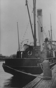 Port Fairy Historical Society Museum and Archives
Photograph, S.S. Casino moored at Casino wharf, Port Fairy
S.S. Casino flagship of the Belfast & Koroit Steam Navigation Company, Purchased 1882. Built in Dundee, ScotlandFirst ship purchased by the Belfast & Koroit Steam Navigation Company in 1882Photographship, boat, sea, river, port fairy, s s casino, belfast & koroit steam navigation company -
 Eltham District Historical Society Inc
Photograph, The Leader, The "Black Swan" Mine and "The Old Dam", Warrandyte Gold Fields, 1897
Reproduced from "The Leader" 14th Aug. 1897, page 7 The "Black Swan" mine - on Captain Selby's property of 200 acres. Discovered by Captain Selby 8 years ago. He is working it himself. 'The shaft is down 70 feet and with deeper sinking the reef is found to increase in width. Nearly £2,000 has been obtained from this mine, the gold being of high quality, fetching £4-1-6 per oz.' Warrandyte photo "The Old Dam" - erected accross the river by Mr John Wallace, M.L.C., who attempted to turn the river and to work the river bed.This photo forms part of a collection of photographs gathered by the Shire of Eltham for their centenary project book,"Pioneers and Painters: 100 years of the Shire of Eltham" by Alan Marshall (1971). The collection of over 500 images is held in partnership between Eltham District Historical Society and Yarra Plenty Regional Library (Eltham Library) and is now formally known as the 'The Shire of Eltham Pioneers Photograph Collection.' It is significant in being the first community sourced collection representing the places and people of the Shire's first one hundred years.Digital imagesepp, shire of eltham pioneers photograph collection, warrandyte, gold mining, black swan mine, old dam -
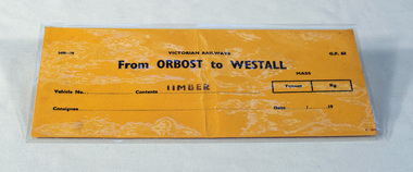 Orbost & District Historical Society
railways envelope, Victorian Railways, c. 1970s-1980s
Used at Orbost railway station for the consignment of goods/freight, in this case, timber to Westall. The Bairnsdale-Orbost railway was opened in 1916 to serve the agricultural and timber industry. Because of the decline in traffic and heavy operating costs, the line was finally closed in August, 1987. Orbost Railway Station was opened on Monday 10 April 1916 as the terminus of the Orbost railway line, and closed in 1987. The station was located on the west side of the Snowy River despite the town of Orbost being on the east side of the river, in order to save on the costs of a bridge over the river, which at the time had highly variable levels. This item is associated with the history of the Orbost-Bairnsdale railway line and therefore reflects the role that the rail line played in the social and economic history of Orbost.An unused brown/buff coloured goods/freight consignment envelope used by Victorian Railways, this one for timber from Orbost to Westall. 2498-78 VICTORIAN RAILWAYS From ORBOST to WESTALL Contents TIMBER railway-history orbost-bairnsdale-railway -
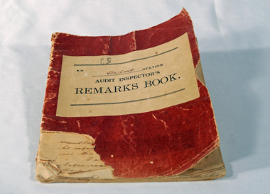 Orbost & District Historical Society
Victorian Railways remarks book, Victorian Railways, c. 1940s
Used at Orbost Railway Station, possibly by the Station Master, between 1944 and 1984. The Bairnsdale-Orbost railway was opened in 1916 to serve the agricultural and timber industry. Because of the decline in traffic and heavy operating costs, the line was finally closed in August, 1987. Orbost Railway Station was opened on Monday 10 April 1916 as the terminus of the Orbost railway line, and closed in 1987. The station was located on the west side of the Snowy River despite the town of Orbost being on the east side of the river, in order to save on the costs of a bridge over the river, which at the time had highly variable levels. This item is associated with the history of the Orbost-Bairnsdale railway line and therefore reflects the role that the rail line played in the social and economic history of Orbost.Book with a red cover. On the front cover VICTORIAN RAILWAYS Audit Inspectors Remarks Book, Orbost. Inside are numbered and lined pages with hand written information dating from 28/3/1944-13/8/1984, dated and signed by various station masters. Cover has a section missing from the bottom left.VICTORIAN RAILWAYS Audit Inspectors Remarks Book, Orbost.railway-history orbost-bairnsdale-railway -
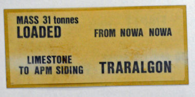 Orbost & District Historical Society
label / sign, 1970's -1980's
This item was used by Victorian Railways in 1980's. It was inserted onto the side of railway freight wagons. The Bairnsdale-Orbost railway was opened in 1916 to serve the agricultural and timber industry. Because of the decline in traffic and heavy operating costs, the line was finally closed in August, 1987. Orbost Railway Station was opened on Monday 10 April 1916 as the terminus of the Orbost railway line, and closed in 1987. The station was located on the west side of the Snowy River despite the town of Orbost being on the east side of the river, in order to save on the costs of a bridge over the river, which at the time had highly variable levels This item is associated with the history of the Orbost-Bairnsdale railway line and therefore reflects the role that the rail line played in the social and economic history of Orbost.A double -sided rectangular shaped label / sign, heavily laminated.Black print on light brown background. On one side : "MASS 31 tonnes LOADED; FROM NOWA NOWA; LIMESTONE TO APM SIDING; TRARALGON". On reverse : "EMPTY FROM TRARALGON; TO APM LIMESTONE SIDING ; NOWA NOWA".freight orbost-bairnsdale-railway -
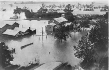 Yarra Glen & District Historical Society
Black and white photographs, Flood waters in Yarra Glen December 1934
Black and white photograph of Bell street, Yarra Glen, taken in December 1934 from the tower of the Grand Hotel, looking south towards the railway crossing, during the floods. The Victoria Hall is the building in the centre of the photograph. Directly behind the Victoria Hall, the roof of 'River View' guest house can be seen. The Shell Garage, operated by Les Orenshaw, on the left of the photograph was originally built and occupied as a peg factory.The view extends from Bell street across the river flats with the high ground of Chateau Yering in the background. Bell Street is defined by the street trees where the water covers the road in the foreground grand hotel, victoria hall, bell street, floods 1934, 1934 flood, railway crossing, river view, guest house, shell garage, peg factory, river flats, chateau yering, les orenshaw, street trees -
 Bendigo Historical Society Inc.
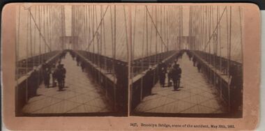
Photograph - HARRIS COLLECTION: STEREOSCOPIC VIEWS, Nineteenth Centur
Stereoscopic views. Kilburn Brothers Littleton , N H. 1. Trinity college Dublin. 2. Brooklyn Bridge, scene of the accident , May 30th 1883. 3. Spinning Room , Mechanics Mill, Fall River Mass. 4. Bay Grove Hill, Greenwood Cemetery, Brooklyn, N Y. 5.Crossing the Great Suspension Bridge, by rail. 6. Dining Hall , Grand Union Hotel, Saratoga, Largest Dining Hall in the World. 7. Phantom Leaves. 8. Full Moon. 9. Merced River, Yo-Semite , Cal. 10. I Breathe Inspiration. 11. United States Hotel Park, Saratoga.Kilburn Brothers Littleton N H.photography, viewers -
 Bendigo Historical Society Inc.
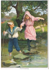
Document - MALONE COLLECTION: GREETING CARDS, 15/1/1910
Coloured picture of a boy wearing a blue & white sailor suit paddling across a stream. He is holding a girl's hand as she walks over the stepping stones in the stream. She is wearing a pink dress & hat and black stockings & shoes. The boy has a pole in his hand. On the bank of the stream is a large tree and some grazing sheep. At the back is a grey building. The picture is mounted on cardboard. 'Horner's Magazine, River of Life Series, MP274, MP275, MP276, & MP277 is written in pen on the back. The picture is titled 'Playmates'. At the top of the picture is printed 'zhorner's Penny Stories 'River of Life' Series No 1. 15.1.1910.personal effects, greeting cards, malone collection, malone collection, greeting cards, horner's magazine river of life series -
 Kew Historical Society Inc
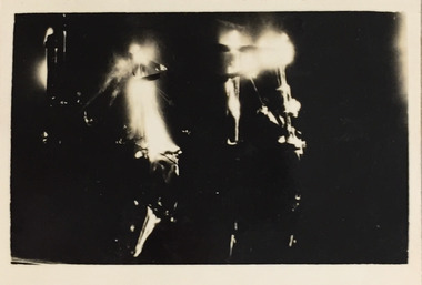
Photograph - Demolishing the Zig-Zag Bridge, 1929
Henry Beater Christian (1886-1962) , was a descendant of one of the earliest settler families in Kew. Employed at the Kew Asylum as a 'public servant', he was a skilled amateur photographer, photographing numerous scenes in Kew and on his travels around Victoria. The majority of his photographs date from 1916 to 1929. His finest photographs are housed in two photograph albums. Rare photograph of the demolition of the Zig-Zag Bridge linking the two asylums on either side of the Yarra River.Digital copy of a photograph from page 16 of the 47-page photograph album containing 261 gelatinous silver images, loaned by Diane Washfold with permission given to digitise and hold a copy in our collection. The Zig-Zag Bridge linked the grounds of the Yarra Bend and Kew Asylums. The wooden bridge was constructed in the 1870s and lasted through numerous floods until its destruction in 1929. A horizontal structure, the walkway was reached via a wooden staircase on the Kew bank of the river. The steps were required due to the different levels of the banks on this stretch of the river. This night-time photograph shows the remaining parts of the bridge being destroyed by fire."Demolishing Zig-Zag / 6. 1929"henry beater christian (1886-1962), landscape photography, kew (vic.) — yarra river, christian-washfold collection, photograph albums, zig-zag bridge -
 Kew Historical Society Inc
Map, MMBW, MMBW Plan No.117 Heidelberg & Kew, 1900-1910
The Melbourne and Metropolitan Board of Works (MMBW) was established by an act of the Victorian Parliament in 1890 to prepare for and to implement a sewerage and water reticulation system across what was then inner Melbourne, its surrounding and middle distance suburbs, including Kew. The MMBW was disbanded in 1991.The map collection of the Kew Historical Society has at its core the historic maps assembled and originally stored in the City Engineer's Department of the City of Kew. These include maps in a number of scales. The vast majority of maps were produced by the MMBW in the first two decades of the twentieth century, and are solid working maps, backed by linen for durability. These maps are historically significant to Kew, the City of Boroondara and to the history of the development of state utilities in Victoria. A number of the Kew maps have additional details added by former municipal officers, including the levels reached by various floods. As these were working documents, information was added to them long after the period of their initial production and distribution.Early map of part of the Borough of Kew, created in the early twentieth century, at a scale 160 ft to 1 inch. The map covers what was then the north eastern part of Kew showing the natural landscape and limited development on the south side of the Yarra River. In the Kew section, south of the river, the land is occupied currently by the Greenacres and Kew Golf Clubs. The map shows the extent of urban development by that time and the outlines of the few built structures in the municipality. The height above sea level of all parts of the landscape are indicated numerically in feet. Contour lines and the levels of historic floods were added in ink to the map at a later stage. MELBOURNE AND METROPOLITAN BOARD OF WORKS / PLAN NO. 117 / HEIDELBERG & KEW melbourne & metropolitan board of works, mmbw maps, borough of kew, cartography, mmbw plan no. 117, kew (vic.) -- maps, heidelberg (vic.) -- maps -
 Wodonga & District Historical Society Inc
Album - Hume Reservoir Australia Album - Excavations for foundations inside coffer dam, January 1927
This set of photos is from a leather bound album bearing the inscription "HUME RESERVOIR AUSTRALIA" plus 'The Rt. Hon. L. C. M. S. Amery, P. C., M .P.' all inscribed in gold. It was presented to The Rt. Hon. L. C. M. S. Amery, P. C., M. P, Secretary of State for Dominion Affairs on the occasion of his visit to the Hume Reservoir on 2nd November 1927. This album is of local and national significance as it documents the planning and development of the Hume Reservoir up to 1927. It was the largest water reservoir in the British Empire. The album records the pioneering engineering work that went into its construction.DEPARTMENT OF PUBLIC WORKS, N.S.W. RIVER MURRAY WATERS SCHEME. HUME RESERVOIR. 21. Excavations for foundations inside coffer dam. New South Wales. January 1927. Cofferdams are temporary structures used where construction is being carried out in areas submerged in water. They are most commonly used to facilitate the construction or repair of dams, piers and bridges. To divert the river, a Coffer Dam was built across the old bed above and below the Dam site and tying into the end of the concrete wall built inside the levee bank. This completely surrounded the remainder of the site of the Dam and south wing wall, including an area of 12½ acres. hume reservoir australia, river murray waters scheme, hume reservoir construction, coffer dam -
 The Beechworth Burke Museum
Photograph, c.1927-1930
This image shows the Punt (a kind of small boat) that took residents of Bethanga across the Murray River before the Bethanga Bridge was built. Bethanga Bridge was built between 1927 and 1930, and was made a necessity by the building of the Hume Dam. The Hume Dam, formerly known as the Hume Weir, was in construction between 1919 and 1936, which swelled the Murray River into the floodplain to the East of the dam permanently, creating Lake Hume, and isolating the residents of Bethanga and nearby towns, for whom the trip all the way around the new lake to another river crossing was a massive undertaking. The person who wrote on the back of this card instead chose to cross the river on a boat until the Bethanga Bridge became available. Interestingly, partially submerged trees can be seen in the lake in the background of this photograph, illustrating that the dam had already begun to fill the floodplain even before the bridge was built. This photograph shows the methods the residents of Bethanga used while the Bethanga Bridge was being built. This record is associated with the Heritage Listed sites of the Hume Dam and the Bethanga Bridge, and shows the environment during the process of construction and the creation of Lake HumeSepia rectangular photograph printed on matte photographic paperReverse: 1997.3189 / 84 -19 -1 / This is the snap of the Punt. / Our only means of getting out / of Bethanga for the present / Until the bridge is completed / it is 2 miles above the junction / of the Mitta + Murray. It is / 1/2 a mile wide + runs across / the Murray into NSW / Kodak Print / bethanga, bethanga bridge, hume, hume dam, artificial lake, lake hume, hume weir, flood, floodplain, boat, punt, weir, pier, dock, transport, transportation -
 Orbost & District Historical Society
black and white photograph, before 1912
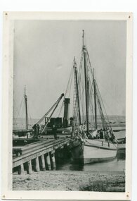
This photo shows the Storm Bird at the end of the jetty and the Wangrabelle in the foreground. Both ships were well known traders. the Wangrabelle became beached and wrecked in 1916 and the Storm Bird became obsolete when the railway from Bairnsdale to Orbost arrived in 1916. (ref. Story of Gippsland Shipping - J.C. Bull) At the start of the river trade goods were shipped from Marlo to Melbourne but when the railway reached Bairnsdale this became unprofitable and the ships plied only between Marlo and Cunninghame. Eventually river transport became economically unviable. The Wongrabelle is still buried in the sands of the entrance of the Snowy River (albeit where the entrance used to be). It took from April 11th 1912 to August 12th 1912 for the loss of the Wongrabelle to be complete, the final entry in the Orbost Shipping Co. records reads:- "The Wongrabelle is completely covered in sand." (ref River, Road, Railway Newsletter O.D.H.S.) This is a pictorial record of a time when the water highways were the only feasible transport mode in sending goods from Orbost and Marlo to Melbourne.A black / white photograph of a ship, sails down, anchored at the Marlo jetty.on back - "M. Gilbert, Wangrabelle at Marlo"storm-bird wangrabelle shipping transport- marlo -
 Port of Echuca
A black and white copy of a photograph, 24/09/1984
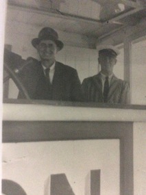
During the Second World War the P.S Marion operated as a passenger vehicle up and down the Murray River.This is a photograph showing Hugh Price steering the P.S. Marion while the Captain looks on! This photograph is linked to P000067, P000065 as they are all part of the Hugh Price Family collection.A copy of a black and white photograph of Hugh Price and Captain George Makins in the wheelhouse of the P.S Marion.In pencil, written on the back is Price / Oct 43 / Capt. Geo Makins, (in cap) & Hugh Price.p.s marion, hugh price, captain george makins, george makins, 1943, price family collection -
 Greensborough Historical Society
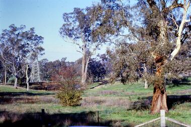
Slide - Photograph, John Ramsdale, Near the confluence of the Plenty and Yarra Rivers, Lower Plenty: Slide 118, 1990s
Photograph shows a rural scene with gumtrees and pylon. This is near the confluence of the Plenty and Yarra Rivers, Lower PlentyPart of the John Ramsdale collection of slides and audio visual material.Colour photograph scanned from slide.No maker's marks. No caption on slide.yarra river, plenty river, lower plenty -
 Greensborough Historical Society
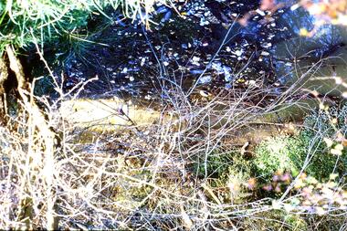
Slide - Photograph, John Ramsdale, Sprayed blackberries: Slide 18, 1990s
Photograph shows sprayed and dead blackberries on the bank of the Plenty River; behind factories on Para Road Montmorency.Part of the John Ramsdale collection of slides and audio visual material.Colour photograph scanned from slide.No maker's marks. No caption on slide.plenty river, weeds, blackberries, para road montmorency -
 Greensborough Historical Society
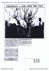
Article, Argus (newspaper), Preserving a link with the past, 08/09/1937
1937 article describing the Apple Tree on Plenty River at Greensborough, its possible origins and steps to preserve it.Early attempts to preserve the Batman Apple Tree and alternative explanations of its origins.Downloaded copy of article. Text and b&w photo. batman apple tree, flintoff, plenty river, greensborough -
 Kiewa Valley Historical Society
Paper - Fishing Guide, Guide for Anglers - December 1975
Ron White Collection. Fishing still is a popular sport in the Kiewa River where competitions are frequently held.Ron White was a keen fisherman and the Kiewa River was famous for its fishing. See KVHS 1282.Two sided foolscap paper titled 'Guide for Anglers - December 1975'.ron white, angler fishing, kiewa river -
 Eltham District Historical Society Inc
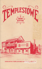
Book, Doncaster Templestowe Historical Society, Templestowe: A Short History by Irvine Green, 1982
Templestowe is a suburb in the City of Manningham on the border of the Yarra River across from which is Eltham, in the Shire of Nillumbik24 p. : ill., 3 maps ISBN 0950092037templestowe -
Federation University Historical Collection
Ethnographic Material, Aboriginal Hammer
A hammerstone is a lump of stone or river coble used in fashioning small stone tools for providing food stuffs.A mudstone in a cylindrical prism shape. It is rather flat at one end, where ther is also evidence on the side stone having been flaked away. The other end is also flattish but more pointed.hammer, aboriginal, stone, ethnography, tools -
Tatura Irrigation & Wartime Camps Museum
Folder, State Rivers & Water Supply Commission - Permanent Staff 1939 -1944, Temporary Staff 1943
Recording of State Rivers & Water Supply Commission permanent staff 1939-1944 and temporary staff 1943Brown folder, white label, blue writing.irrigation, documents, reports -
Tatura Irrigation & Wartime Camps Museum
Audio Tape, 75th Anniversary of the formation of the State Rivers & Water Supply Commission. Sir Ronald East the guest speaker
75th Anniversary of the formation of the State Rivers & Water Supply Commission. Sir Ronald East the guest speaker.audio, visual, technology, accessory -
 Peterborough History Group
Photograph - Four copies of photographs of the Peterborough Old Bridge
Varying views of the old bridge, which was a valuable connection to the East side of the river. A view of the landscape at that time.Historic views of the town and bridge 4 photocopied reproductions of different aspects of the Old bridge at Peterborough, including one which is a copy of The Rose Series Postcards No P2470.peterborough, peterborough old bridge, curdies river bridge, rose series postcards, rose series p2470 -
National Wool Museum
Book, John Drysdale and the Burdekin
"John Drysdale and the Burdekin" -Roy Connolly, 1964. Includes "Burdekin River sketchbook" 16pp, by Russell Drysdale.agriculture wool growing, agriculture, wool growing -
National Wool Museum
Shoes
Australian womens shoes from the formal uniform for the Sydney 2000 Olympic Games. Manufactured by Rivers Shoes.fashion, woolmark company rivers shoes, sport, the woolmark company 2000 australian olympic display - exhibition (21/12/2001 - 24/05/2002)