Showing 4370 items
matching specials
-
 Eltham District Historical Society Inc
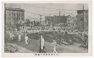
Photograph - Postcard, The Great Tokyo Earthquake on September 1st, 1923: Ruins of burned streetcars, Tokyo, 1923
The Great Kantō Earthquake of 1 September 1923 devastated the major cities of Tokyo and Yokohama, as well as five other surrounding prefectures and was one of the world’s worst natural disasters of the early twentieth century. In terms of loss of life and material damage, with an estimated 140,000 deaths and countless homeless, it is still Japan’s worst national disaster. Nearly 90% of the newspaper printers were destroyed in the earthquake. These postcards were not produced for aesthetics but as a major tool for the spread of information. Seeing how newspaper companies were left with their offices in shambles, postcard publishers tried to fill the gap hence some were in three languages. A very small number of publishing companies were fortunate enough to survive, one of them being Mitsumura Printing, which took advantage of its remaining resources to churn out postcards. When the Ōsaka Mainichi Shinbunsha published its bilingual three-volume photographic pictorial of the Great Kantō Earthquake just two weeks after the event, the calamity had already been captured in thousands of images that circulated on a national and international media highway. Commercial photographers and photojournalists produced the most abundant and immediate images of the quake, which were transmitted in newspapers, special-issue newspaper pictorials, commemorative photography collections, illustrated survivors’ accounts, and sets of commemorative postcards. These photographic images functioned as both news and souvenirs, rendering their consumers/viewers, inside and outside the devastated locale, into both witnesses and voyeurs. Images in the news media and those issued by respected publishing houses carried the visual authority of supposed facticity. As such they both produced and became the historical record of the event. Since the vast majority of 1923 disaster postcards that survive have no writing on them, they were likely treated more as collectibles than as a form of postal communication. Many were put into albums, creating new ways to combine images and create visual cultures of disaster for home viewing. Accordion-style albums allowed for personalized, serial organization of images that produced unique, imagistic narratives of the event. The album pages were also two-sided and could be stretched out to view a series of images on recto and verso. References: Imaging Disaster: Tokyo and the Visual Culture of Japan’s Great Earthquake of 1923 震災をイメージ化する 東京と1923年関東大震災のヴィジュアルカルチャー - The Asia. (2024, March 31). Retrieved from https://apjjf.org/2015/13/6/gennifer-weisenfeld/4270 The Great Kanto Earthquake: Postcards of Tragedy. (2024, March 31). Retrieved from https://www.tokyoweekender.com/art_and_culture/japanese-culture/the-great-kanto-earthquake-postcards/ See also: Postcards from Hell – Glimpses of the Great Kantō Earthquake; M. William STEELE (International Christian University, Japan) 14th Conference of the European Association of Japanese Studies: Visual Culture and Postcard Research Papers – East Asia Image Collection Blog. (2024, March 31). Retrieved from https://sites.lafayette.edu/eastasia/2014/09/01/14th-conference-of-the-european-association-of-japanese-studies-visual-culture-and-postcard-research-papers/] And https://icu.repo.nii.ac.jp/record/4503/files/ACS44_01Steele.pdfThis item, a souvenir from Japan from between the wars (circa 1923) was brought home to Research, Victoria by Bill Teagle who was serving in the Royal Australian Navy (1919-1945). Bill Teagle's sister Violet Amelda Teagle had married Theodore (Curly) Feldbauer in 1933. Bill's brother-in-law Curly was taken as a Prisoner of War by the Japanese and died at Sandakan in March 1945. The family did not learn of Curly’s death till months later and Bill's sister, Violet, herself could never forgive the Japanese for what happened to Curly. Curly is remembered on the Eltham Roll of Honour Board and his son, Albert Feldbauer (Bill’s nephew and youngest child of the children of the soldier fathers attending a school in the district), was given the honour of turning the first sod for the Eltham War Memorial Infant Welfare Centre Building. Despite this, the family maintained this cherished souvenir from a time of previous foreign friendship with Japan. The item was possibly given by Bill Teagle to his sister Margaret Rose (formerly Ingram) who later married Richard Edward (Eddie) Fielding in early 1948. (Eddie had been engaged to someone else before he went to war, but his fiancée broke it off before his return to Australia.) It was cared for by the Teagle/Fielding family for approximately one hundred years. It is of particular significance given the family's connection to the Eltham War Memorial and the significance of that memorial to the local community and represents that despite the horrors of war, former friends then foes can become friends again.tom fielding collection, japanese postcard, postcard, 1923, great kanto earthquake, japan, tokyo, yokohama -
 Eltham District Historical Society Inc
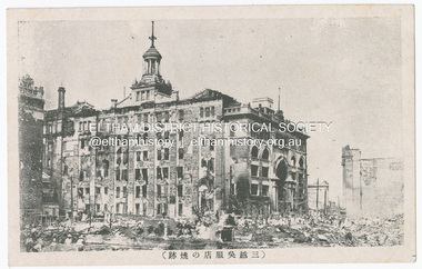
Photograph - Postcard, The Great Tokyo Earthquake on September 1st, 1923: Burned ruins of the Mitsukoshi Kimono Store, Tokyo, 1923
The Great Kantō Earthquake of 1 September 1923 devastated the major cities of Tokyo and Yokohama, as well as five other surrounding prefectures and was one of the world’s worst natural disasters of the early twentieth century. In terms of loss of life and material damage, with an estimated 140,000 deaths and countless homeless, it is still Japan’s worst national disaster. Nearly 90% of the newspaper printers were destroyed in the earthquake. These postcards were not produced for aesthetics but as a major tool for the spread of information. Seeing how newspaper companies were left with their offices in shambles, postcard publishers tried to fill the gap hence some were in three languages. A very small number of publishing companies were fortunate enough to survive, one of them being Mitsumura Printing, which took advantage of its remaining resources to churn out postcards. When the Ōsaka Mainichi Shinbunsha published its bilingual three-volume photographic pictorial of the Great Kantō Earthquake just two weeks after the event, the calamity had already been captured in thousands of images that circulated on a national and international media highway. Commercial photographers and photojournalists produced the most abundant and immediate images of the quake, which were transmitted in newspapers, special-issue newspaper pictorials, commemorative photography collections, illustrated survivors’ accounts, and sets of commemorative postcards. These photographic images functioned as both news and souvenirs, rendering their consumers/viewers, inside and outside the devastated locale, into both witnesses and voyeurs. Images in the news media and those issued by respected publishing houses carried the visual authority of supposed facticity. As such they both produced and became the historical record of the event. Since the vast majority of 1923 disaster postcards that survive have no writing on them, they were likely treated more as collectibles than as a form of postal communication. Many were put into albums, creating new ways to combine images and create visual cultures of disaster for home viewing. Accordion-style albums allowed for personalized, serial organization of images that produced unique, imagistic narratives of the event. The album pages were also two-sided and could be stretched out to view a series of images on recto and verso. References: Imaging Disaster: Tokyo and the Visual Culture of Japan’s Great Earthquake of 1923 震災をイメージ化する 東京と1923年関東大震災のヴィジュアルカルチャー - The Asia. (2024, March 31). Retrieved from https://apjjf.org/2015/13/6/gennifer-weisenfeld/4270 The Great Kanto Earthquake: Postcards of Tragedy. (2024, March 31). Retrieved from https://www.tokyoweekender.com/art_and_culture/japanese-culture/the-great-kanto-earthquake-postcards/ See also: Postcards from Hell – Glimpses of the Great Kantō Earthquake; M. William STEELE (International Christian University, Japan) 14th Conference of the European Association of Japanese Studies: Visual Culture and Postcard Research Papers – East Asia Image Collection Blog. (2024, March 31). Retrieved from https://sites.lafayette.edu/eastasia/2014/09/01/14th-conference-of-the-european-association-of-japanese-studies-visual-culture-and-postcard-research-papers/] And https://icu.repo.nii.ac.jp/record/4503/files/ACS44_01Steele.pdfThis item, a souvenir from Japan from between the wars (circa 1923) was brought home to Research, Victoria by Bill Teagle who was serving in the Royal Australian Navy (1919-1945). Bill Teagle's sister Violet Amelda Teagle had married Theodore (Curly) Feldbauer in 1933. Bill's brother-in-law Curly was taken as a Prisoner of War by the Japanese and died at Sandakan in March 1945. The family did not learn of Curly’s death till months later and Bill's sister, Violet, herself could never forgive the Japanese for what happened to Curly. Curly is remembered on the Eltham Roll of Honour Board and his son, Albert Feldbauer (Bill’s nephew and youngest child of the children of the soldier fathers attending a school in the district), was given the honour of turning the first sod for the Eltham War Memorial Infant Welfare Centre Building. Despite this, the family maintained this cherished souvenir from a time of previous foreign friendship with Japan. The item was possibly given by Bill Teagle to his sister Margaret Rose (formerly Ingram) who later married Richard Edward (Eddie) Fielding in early 1948. (Eddie had been engaged to someone else before he went to war, but his fiancée broke it off before his return to Australia.) It was cared for by the Teagle/Fielding family for approximately one hundred years. It is of particular significance given the family's connection to the Eltham War Memorial and the significance of that memorial to the local community and represents that despite the horrors of war, former friends then foes can become friends again.tom fielding collection, japanese postcard, postcard, 1923, great kanto earthquake, japan, tokyo, yokohama -
 Eltham District Historical Society Inc
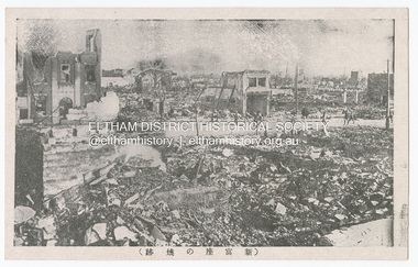
Photograph - Postcard, The Great Tokyo Earthquake on September 1st, 1923: Burnt remains of Shintomi Theatre, built in 1630 for Kabuki Theatre, 1923
The Great Kantō Earthquake of 1 September 1923 devastated the major cities of Tokyo and Yokohama, as well as five other surrounding prefectures and was one of the world’s worst natural disasters of the early twentieth century. In terms of loss of life and material damage, with an estimated 140,000 deaths and countless homeless, it is still Japan’s worst national disaster. Nearly 90% of the newspaper printers were destroyed in the earthquake. These postcards were not produced for aesthetics but as a major tool for the spread of information. Seeing how newspaper companies were left with their offices in shambles, postcard publishers tried to fill the gap hence some were in three languages. A very small number of publishing companies were fortunate enough to survive, one of them being Mitsumura Printing, which took advantage of its remaining resources to churn out postcards. When the Ōsaka Mainichi Shinbunsha published its bilingual three-volume photographic pictorial of the Great Kantō Earthquake just two weeks after the event, the calamity had already been captured in thousands of images that circulated on a national and international media highway. Commercial photographers and photojournalists produced the most abundant and immediate images of the quake, which were transmitted in newspapers, special-issue newspaper pictorials, commemorative photography collections, illustrated survivors’ accounts, and sets of commemorative postcards. These photographic images functioned as both news and souvenirs, rendering their consumers/viewers, inside and outside the devastated locale, into both witnesses and voyeurs. Images in the news media and those issued by respected publishing houses carried the visual authority of supposed facticity. As such they both produced and became the historical record of the event. Since the vast majority of 1923 disaster postcards that survive have no writing on them, they were likely treated more as collectibles than as a form of postal communication. Many were put into albums, creating new ways to combine images and create visual cultures of disaster for home viewing. Accordion-style albums allowed for personalized, serial organization of images that produced unique, imagistic narratives of the event. The album pages were also two-sided and could be stretched out to view a series of images on recto and verso. References: Imaging Disaster: Tokyo and the Visual Culture of Japan’s Great Earthquake of 1923 震災をイメージ化する 東京と1923年関東大震災のヴィジュアルカルチャー - The Asia. (2024, March 31). Retrieved from https://apjjf.org/2015/13/6/gennifer-weisenfeld/4270 The Great Kanto Earthquake: Postcards of Tragedy. (2024, March 31). Retrieved from https://www.tokyoweekender.com/art_and_culture/japanese-culture/the-great-kanto-earthquake-postcards/ See also: Postcards from Hell – Glimpses of the Great Kantō Earthquake; M. William STEELE (International Christian University, Japan) 14th Conference of the European Association of Japanese Studies: Visual Culture and Postcard Research Papers – East Asia Image Collection Blog. (2024, March 31). Retrieved from https://sites.lafayette.edu/eastasia/2014/09/01/14th-conference-of-the-european-association-of-japanese-studies-visual-culture-and-postcard-research-papers/] And https://icu.repo.nii.ac.jp/record/4503/files/ACS44_01Steele.pdfThis item, a souvenir from Japan from between the wars (circa 1923) was brought home to Research, Victoria by Bill Teagle who was serving in the Royal Australian Navy (1919-1945). Bill Teagle's sister Violet Amelda Teagle had married Theodore (Curly) Feldbauer in 1933. Bill's brother-in-law Curly was taken as a Prisoner of War by the Japanese and died at Sandakan in March 1945. The family did not learn of Curly’s death till months later and Bill's sister, Violet, herself could never forgive the Japanese for what happened to Curly. Curly is remembered on the Eltham Roll of Honour Board and his son, Albert Feldbauer (Bill’s nephew and youngest child of the children of the soldier fathers attending a school in the district), was given the honour of turning the first sod for the Eltham War Memorial Infant Welfare Centre Building. Despite this, the family maintained this cherished souvenir from a time of previous foreign friendship with Japan. The item was possibly given by Bill Teagle to his sister Margaret Rose (formerly Ingram) who later married Richard Edward (Eddie) Fielding in early 1948. (Eddie had been engaged to someone else before he went to war, but his fiancée broke it off before his return to Australia.) It was cared for by the Teagle/Fielding family for approximately one hundred years. It is of particular significance given the family's connection to the Eltham War Memorial and the significance of that memorial to the local community and represents that despite the horrors of war, former friends then foes can become friends again.tom fielding collection, japanese postcard, postcard, 1923, great kanto earthquake, japan, tokyo, yokohama -
 Eltham District Historical Society Inc
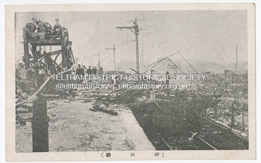
Photograph - Postcard, The Great Tokyo Earthquake on September 1st, 1923: Kanda Ryo, Chiyoda Ward, Tokyo - Kanda Station in the suburbs, 1923
The Great Kantō Earthquake of 1 September 1923 devastated the major cities of Tokyo and Yokohama, as well as five other surrounding prefectures and was one of the world’s worst natural disasters of the early twentieth century. In terms of loss of life and material damage, with an estimated 140,000 deaths and countless homeless, it is still Japan’s worst national disaster. Nearly 90% of the newspaper printers were destroyed in the earthquake. These postcards were not produced for aesthetics but as a major tool for the spread of information. Seeing how newspaper companies were left with their offices in shambles, postcard publishers tried to fill the gap hence some were in three languages. A very small number of publishing companies were fortunate enough to survive, one of them being Mitsumura Printing, which took advantage of its remaining resources to churn out postcards. When the Ōsaka Mainichi Shinbunsha published its bilingual three-volume photographic pictorial of the Great Kantō Earthquake just two weeks after the event, the calamity had already been captured in thousands of images that circulated on a national and international media highway. Commercial photographers and photojournalists produced the most abundant and immediate images of the quake, which were transmitted in newspapers, special-issue newspaper pictorials, commemorative photography collections, illustrated survivors’ accounts, and sets of commemorative postcards. These photographic images functioned as both news and souvenirs, rendering their consumers/viewers, inside and outside the devastated locale, into both witnesses and voyeurs. Images in the news media and those issued by respected publishing houses carried the visual authority of supposed facticity. As such they both produced and became the historical record of the event. Since the vast majority of 1923 disaster postcards that survive have no writing on them, they were likely treated more as collectibles than as a form of postal communication. Many were put into albums, creating new ways to combine images and create visual cultures of disaster for home viewing. Accordion-style albums allowed for personalized, serial organization of images that produced unique, imagistic narratives of the event. The album pages were also two-sided and could be stretched out to view a series of images on recto and verso. References: Imaging Disaster: Tokyo and the Visual Culture of Japan’s Great Earthquake of 1923 震災をイメージ化する 東京と1923年関東大震災のヴィジュアルカルチャー - The Asia. (2024, March 31). Retrieved from https://apjjf.org/2015/13/6/gennifer-weisenfeld/4270 The Great Kanto Earthquake: Postcards of Tragedy. (2024, March 31). Retrieved from https://www.tokyoweekender.com/art_and_culture/japanese-culture/the-great-kanto-earthquake-postcards/ See also: Postcards from Hell – Glimpses of the Great Kantō Earthquake; M. William STEELE (International Christian University, Japan) 14th Conference of the European Association of Japanese Studies: Visual Culture and Postcard Research Papers – East Asia Image Collection Blog. (2024, March 31). Retrieved from https://sites.lafayette.edu/eastasia/2014/09/01/14th-conference-of-the-european-association-of-japanese-studies-visual-culture-and-postcard-research-papers/] And https://icu.repo.nii.ac.jp/record/4503/files/ACS44_01Steele.pdfThis item, a souvenir from Japan from between the wars (circa 1923) was brought home to Research, Victoria by Bill Teagle who was serving in the Royal Australian Navy (1919-1945). Bill Teagle's sister Violet Amelda Teagle had married Theodore (Curly) Feldbauer in 1933. Bill's brother-in-law Curly was taken as a Prisoner of War by the Japanese and died at Sandakan in March 1945. The family did not learn of Curly’s death till months later and Bill's sister, Violet, herself could never forgive the Japanese for what happened to Curly. Curly is remembered on the Eltham Roll of Honour Board and his son, Albert Feldbauer (Bill’s nephew and youngest child of the children of the soldier fathers attending a school in the district), was given the honour of turning the first sod for the Eltham War Memorial Infant Welfare Centre Building. Despite this, the family maintained this cherished souvenir from a time of previous foreign friendship with Japan. The item was possibly given by Bill Teagle to his sister Margaret Rose (formerly Ingram) who later married Richard Edward (Eddie) Fielding in early 1948. (Eddie had been engaged to someone else before he went to war, but his fiancée broke it off before his return to Australia.) It was cared for by the Teagle/Fielding family for approximately one hundred years. It is of particular significance given the family's connection to the Eltham War Memorial and the significance of that memorial to the local community and represents that despite the horrors of war, former friends then foes can become friends again.tom fielding collection, japanese postcard, postcard, 1923, great kanto earthquake, japan, tokyo, yokohama -
 Eltham District Historical Society Inc
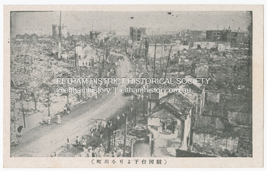
Photograph - Postcard, The Great Tokyo Earthquake on September 1st, 1923: The business disctrict, Ogawamachi Street, Kanda, Tokyo, 1923
The Great Kantō Earthquake of 1 September 1923 devastated the major cities of Tokyo and Yokohama, as well as five other surrounding prefectures and was one of the world’s worst natural disasters of the early twentieth century. In terms of loss of life and material damage, with an estimated 140,000 deaths and countless homeless, it is still Japan’s worst national disaster. Nearly 90% of the newspaper printers were destroyed in the earthquake. These postcards were not produced for aesthetics but as a major tool for the spread of information. Seeing how newspaper companies were left with their offices in shambles, postcard publishers tried to fill the gap hence some were in three languages. A very small number of publishing companies were fortunate enough to survive, one of them being Mitsumura Printing, which took advantage of its remaining resources to churn out postcards. When the Ōsaka Mainichi Shinbunsha published its bilingual three-volume photographic pictorial of the Great Kantō Earthquake just two weeks after the event, the calamity had already been captured in thousands of images that circulated on a national and international media highway. Commercial photographers and photojournalists produced the most abundant and immediate images of the quake, which were transmitted in newspapers, special-issue newspaper pictorials, commemorative photography collections, illustrated survivors’ accounts, and sets of commemorative postcards. These photographic images functioned as both news and souvenirs, rendering their consumers/viewers, inside and outside the devastated locale, into both witnesses and voyeurs. Images in the news media and those issued by respected publishing houses carried the visual authority of supposed facticity. As such they both produced and became the historical record of the event. Since the vast majority of 1923 disaster postcards that survive have no writing on them, they were likely treated more as collectibles than as a form of postal communication. Many were put into albums, creating new ways to combine images and create visual cultures of disaster for home viewing. Accordion-style albums allowed for personalized, serial organization of images that produced unique, imagistic narratives of the event. The album pages were also two-sided and could be stretched out to view a series of images on recto and verso. References: Imaging Disaster: Tokyo and the Visual Culture of Japan’s Great Earthquake of 1923 震災をイメージ化する 東京と1923年関東大震災のヴィジュアルカルチャー - The Asia. (2024, March 31). Retrieved from https://apjjf.org/2015/13/6/gennifer-weisenfeld/4270 The Great Kanto Earthquake: Postcards of Tragedy. (2024, March 31). Retrieved from https://www.tokyoweekender.com/art_and_culture/japanese-culture/the-great-kanto-earthquake-postcards/ See also: Postcards from Hell – Glimpses of the Great Kantō Earthquake; M. William STEELE (International Christian University, Japan) 14th Conference of the European Association of Japanese Studies: Visual Culture and Postcard Research Papers – East Asia Image Collection Blog. (2024, March 31). Retrieved from https://sites.lafayette.edu/eastasia/2014/09/01/14th-conference-of-the-european-association-of-japanese-studies-visual-culture-and-postcard-research-papers/] And https://icu.repo.nii.ac.jp/record/4503/files/ACS44_01Steele.pdfThis item, a souvenir from Japan from between the wars (circa 1923) was brought home to Research, Victoria by Bill Teagle who was serving in the Royal Australian Navy (1919-1945). Bill Teagle's sister Violet Amelda Teagle had married Theodore (Curly) Feldbauer in 1933. Bill's brother-in-law Curly was taken as a Prisoner of War by the Japanese and died at Sandakan in March 1945. The family did not learn of Curly’s death till months later and Bill's sister, Violet, herself could never forgive the Japanese for what happened to Curly. Curly is remembered on the Eltham Roll of Honour Board and his son, Albert Feldbauer (Bill’s nephew and youngest child of the children of the soldier fathers attending a school in the district), was given the honour of turning the first sod for the Eltham War Memorial Infant Welfare Centre Building. Despite this, the family maintained this cherished souvenir from a time of previous foreign friendship with Japan. The item was possibly given by Bill Teagle to his sister Margaret Rose (formerly Ingram) who later married Richard Edward (Eddie) Fielding in early 1948. (Eddie had been engaged to someone else before he went to war, but his fiancée broke it off before his return to Australia.) It was cared for by the Teagle/Fielding family for approximately one hundred years. It is of particular significance given the family's connection to the Eltham War Memorial and the significance of that memorial to the local community and represents that despite the horrors of war, former friends then foes can become friends again.tom fielding collection, japanese postcard, postcard, 1923, great kanto earthquake, japan, tokyo, yokohama -
 Eltham District Historical Society Inc
Photograph - Postcard, The Great Tokyo Earthquake on September 1st, 1923: Taisho 12 Near Shinbashi Station, Tokyo, 1923
The Great Kantō Earthquake of 1 September 1923 devastated the major cities of Tokyo and Yokohama, as well as five other surrounding prefectures and was one of the world’s worst natural disasters of the early twentieth century. In terms of loss of life and material damage, with an estimated 140,000 deaths and countless homeless, it is still Japan’s worst national disaster. Nearly 90% of the newspaper printers were destroyed in the earthquake. These postcards were not produced for aesthetics but as a major tool for the spread of information. Seeing how newspaper companies were left with their offices in shambles, postcard publishers tried to fill the gap hence some were in three languages. A very small number of publishing companies were fortunate enough to survive, one of them being Mitsumura Printing, which took advantage of its remaining resources to churn out postcards. When the Ōsaka Mainichi Shinbunsha published its bilingual three-volume photographic pictorial of the Great Kantō Earthquake just two weeks after the event, the calamity had already been captured in thousands of images that circulated on a national and international media highway. Commercial photographers and photojournalists produced the most abundant and immediate images of the quake, which were transmitted in newspapers, special-issue newspaper pictorials, commemorative photography collections, illustrated survivors’ accounts, and sets of commemorative postcards. These photographic images functioned as both news and souvenirs, rendering their consumers/viewers, inside and outside the devastated locale, into both witnesses and voyeurs. Images in the news media and those issued by respected publishing houses carried the visual authority of supposed facticity. As such they both produced and became the historical record of the event. Since the vast majority of 1923 disaster postcards that survive have no writing on them, they were likely treated more as collectibles than as a form of postal communication. Many were put into albums, creating new ways to combine images and create visual cultures of disaster for home viewing. Accordion-style albums allowed for personalized, serial organization of images that produced unique, imagistic narratives of the event. The album pages were also two-sided and could be stretched out to view a series of images on recto and verso. References: Imaging Disaster: Tokyo and the Visual Culture of Japan’s Great Earthquake of 1923 震災をイメージ化する 東京と1923年関東大震災のヴィジュアルカルチャー - The Asia. (2024, March 31). Retrieved from https://apjjf.org/2015/13/6/gennifer-weisenfeld/4270 The Great Kanto Earthquake: Postcards of Tragedy. (2024, March 31). Retrieved from https://www.tokyoweekender.com/art_and_culture/japanese-culture/the-great-kanto-earthquake-postcards/ See also: Postcards from Hell – Glimpses of the Great Kantō Earthquake; M. William STEELE (International Christian University, Japan) 14th Conference of the European Association of Japanese Studies: Visual Culture and Postcard Research Papers – East Asia Image Collection Blog. (2024, March 31). Retrieved from https://sites.lafayette.edu/eastasia/2014/09/01/14th-conference-of-the-european-association-of-japanese-studies-visual-culture-and-postcard-research-papers/] And https://icu.repo.nii.ac.jp/record/4503/files/ACS44_01Steele.pdfThis item, a souvenir from Japan from between the wars (circa 1923) was brought home to Research, Victoria by Bill Teagle who was serving in the Royal Australian Navy (1919-1945). Bill Teagle's sister Violet Amelda Teagle had married Theodore (Curly) Feldbauer in 1933. Bill's brother-in-law Curly was taken as a Prisoner of War by the Japanese and died at Sandakan in March 1945. The family did not learn of Curly’s death till months later and Bill's sister, Violet, herself could never forgive the Japanese for what happened to Curly. Curly is remembered on the Eltham Roll of Honour Board and his son, Albert Feldbauer (Bill’s nephew and youngest child of the children of the soldier fathers attending a school in the district), was given the honour of turning the first sod for the Eltham War Memorial Infant Welfare Centre Building. Despite this, the family maintained this cherished souvenir from a time of previous foreign friendship with Japan. The item was possibly given by Bill Teagle to his sister Margaret Rose (formerly Ingram) who later married Richard Edward (Eddie) Fielding in early 1948. (Eddie had been engaged to someone else before he went to war, but his fiancée broke it off before his return to Australia.) It was cared for by the Teagle/Fielding family for approximately one hundred years. It is of particular significance given the family's connection to the Eltham War Memorial and the significance of that memorial to the local community and represents that despite the horrors of war, former friends then foes can become friends again.tom fielding collection, japanese postcard, postcard, 1923, great kanto earthquake, japan, tokyo, yokohama -
 City of Moorabbin Historical Society (Operating the Box Cottage Museum)
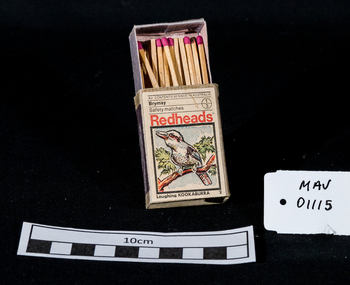
Containers, matchbox 'Redhead' with matches, 20thC
On 15th December 1909, Bryant & May, Australia’s first match factory at Church Street, Richmond, Victoria. was opened by The Honourable Alfred Deakin, Prime Minister of Australia, and Mrs. Deakin. It was heralded by the first Commonwealth Government of newly-federated Australia because the government of the day was anxious to encourage secondary industry and pledged tariff protection of local manufacturers. The building was constructed in 1909 as the Empire Works to a design by prolific Melbourne architect William Pitt and was purchased soon after by British safety match manufacturer Bryant and May, who significantly expanded the building, adding another level and the landmark clock tower. Bryant and May were unique in that they operated as a model factory, providing workers with conditions and amenities that even today seem generous. These included a dining hall and sports facilities such as a tennis court and bowling green which were constructed in the 1920s. Bryant and May ceased Australian match manufacture in the early 1980s as a result of import competition. Their iconic Redheads matches are now imported from Sweden. The complex has since been converted for use as offices and showrooms but is extremely well preserved. It is listed on the Victorian Heritage Register. Bryant and May was a United Kingdom (UK) company created in the mid-nineteenth century specifically to make matches. Their original Bryant and May Factory was located in Bow, London. They later opened other match factories in the United Kingdom and Australia, such as the Bryant and May Factory, Melbourne; and owned match factories in other parts of the world. Bryant and May survived as an independent company for over seventy years, but went through a series of mergers with other match companies and later with consumer products companies. To protect its position Bryant and May merged with or took over its rivals. In 1971 the Northern Ireland factory, Maguire & Patterson closed down following a terrorist attack.. In the 1980s, factories in Gloucester and Glasgow closed too leaving Liverpool as the last match factory in the UK, until December 1994. . The registered trade name Bryant and May still exists and it is owned by Swedish Match, as are many of the other registered trade names of the other, formerly independent, companies within the Bryant and May group. Two French chemists, Henri Savene and Emile David Cahen, proved in 1898 that the addition of phosphorus sesquisulfide meant that the substance was not poisonous, that it could be used in a "strike-anywhere" match, and that the match heads were not explosive. British company Albright and Wilson, was the first company to produce phosphorus sesquisulfide ( Red Phosphorous) matches commercially. The company developed a safe means of making commercial quantities of phosphorus sesquisulfide in 1899 and started selling it to match manufacturers. Matches were first produced by Bryant & May in Australia in 1909. The Redhead name applies to the red striking heads of the matches which were introduced to Australia in 1946. The logo on the matchbox depicted the head and shoulder of a redheaded woman and has had four major updates since that time with a number of special issues depicting birds, animals and notable persons also produced.The Bryant & May Ltd factory in Church St Richmond is a listed building and has been converted to apartments following the closure of the Company 1980. Bryant & May's Ltd were influential in fighting against the dreadful disease known as Phossy jaw which was caused by white phosphorus used in the manufacture of the early matches. They were also the object of the 'Match Girls Strike' in London 1888, which won important improvements in working conditions and pay for the mostly female workforce working with the dangerous white phosphorus. The public were slow to purchase these safety matches because of the higher price .A box of safety matches with unused matches made by Bryant & May Pty Ltd , Richmond Victoria Australia. The tray containing the matches slides inside the open ended cover.. The striking patch is on both sides of the cover. Av. CONTENTS 50 MADE IN AUSTRALIA / Brymay / 1/3 / Safety Matches / Redheads / a colour picture of a Kookaburra / Laughing KOOKABURRAsafety matches, bryant & may pty ltd, phossy jaw disease, early settlers, moorabbin, bentleigh, cheltenham, lights, lamps, tobacco, white phosphorous, phosphorus sesquisulfide, swedish match pty ltd, pitt william, savens henri, cahen emile david , richmond victoria, -
 Flagstaff Hill Maritime Museum and Village
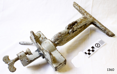
Tool - Bench Saw Vice, Henry Disston & Sons, 1910 -1925
The subject item is a saw blade sharpening clamp that attaches to a bench allowing the operator to sharpen the teeth on a saw with a file while keeping the saw blade in an upright position. Henry Disston (1819–1878) began his career as an American saw maker in Philadelphia. He emigrated from England in 1833 and started making saws and squares in 1840. In 1850, he founded the company that would become the largest saw maker in the world the ”Keystone Saw Works” on the Delaware River. Some five years later, Disston built a furnace possibly the first melting plant for steel in America and began producing the first crucible saw steel ever made in the United States. While his competitors were buying good steel from Britain, he was making his own, to his specification, for his own needs. Disston subsequently constructed a special rolling mill exclusively for saw blades. Over the following decade, the Disston company continued to grow, even while dedicating itself to the Union Army's war effort. In 1865, when his son Hamilton Disston rejoined the business after serving in the Civil War, Disston changed the company's name to Henry Disston & Son. Henry Disston and his sons set the standards for American saw makers, both in terms of producing high-quality saws and developing innovative manufacturing techniques. Disston also started making files in 1865. In September 1872, Henry Disston and two other men dug a part of the foundation for what was to become the largest saw manufacturing facility in the world: Disston Saw Works. This was in the Tacony section of Philadelphia. Having previously moved his expanding business from near Second and Market Streets to Front and Laurel Streets, Disston sought to establish his business away from this cramped area. It took over 25 years to move the entire facility to Tacony. This Philadelphia neighborhood seems to have been the only company town in the United States established within an existing city. At its peak of operations, Disston Saw Works employed 8,000 people and the factory covered 300 acres. The company, known as Henry Disston and Sons, Inc by the early 20th century, cast the first crucible steel in the nation from an electric furnace in 1906. The firm's Armour plate building near Princeton Avenue and Milnor Street contributed tremendously to the World War II effort. But the company's innovation and industriousness would not last forever. In 1955, with mounting cash-flow problems and waning interest on the family's part to run the firm, Henry Disston and Sons were sold to the H.K. Porter Company of Pittsburgh. Porter's Disston Division was sold in 1978 and became the Henry Disston Division of Sandvik Saw of Sweden. This division was then sold in 1984 to R.A.F. Industries of Philadelphia and became known as Disston Precision Incorporated, a maker of specialized flat steel products. In 2013, R.A.F. Industries sold Disston Precision Inc. in a private sale. Although the company has ceased making Disston handsaws, the Disston brand name still exists in this firm. A significant American company that pioneered the making of high-quality steel and saws along with other tools and accessories. The subject item is significant as it was made at a time when the company was in its hay day. Adjustable Ball & Socket Saw Sharpening vice, cast iron, with clamp to attach to a workbench. Made by Henry Disston & Co. No 1 painted greyflagstaff hill, warrnambool, flagstaff-hill, flagstaff-hill-maritime-museum, maritime-museum, shipwreck-coast, flagstaff-hill-maritime-village, saw clamp, henry disston & sons, saw sharpening, tool accessories, wood saws -
 Uniting Church Archives - Synod of Victoria
Photograph, undated c.1980s
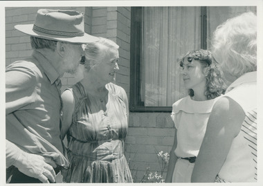
Rosalie Rayment originally trained and worked as an Occupational Therapist. Following completion of studies in Theology she worked for 11 years with the Church in Thailand. Rosalie was ordained in 1988. Fred Vanclay B.D., Dip AgS. ordained 1964 in the Presbyterian Church. Served: Queensland 1961 - 1975; Victoria 1976 - 1985 Vermont - Parkmore; Northern Territory Tennant-Barkly Patrol 1985 - 1993. Died in 2016. Adapted from the eulogy given by his son, Jerry Vanclay One of Fred’s first placements as a minister was in Mackay, North Queensland. Mackay was a wonderful place for Fred, his wife Donna and their young family. They all loved the beaches and the bush, and the children completed a significant part of their schooling there. Whilst posted in Mackay, Fred and Donna enjoyed long road trips in their modest HR Holden sedan, with the family, to Uluru, to Broome via the Borroloola Track, and down the Birdsville Track to the Flinders ranges; along the way, developing the bushcraft that would stand them in good stead later in the Tennant-Barkly Patrol. After many years in ministry in Mackay, then in Vermont, Victoria, Fred and Donna were called to the Tennant-Barkly Patrol in the Northern Territory, where he served for eight years, probably Fred’s most satisfying years. All Fred’s parishes were welcoming and rewarding, but Fred said on more than one occasion that he had a special love for the Patrol. He felt that in an urban congregation, he ministered mainly to those who came to Church, but in the Patrol he ministered to everyone, and especially to those in need. Fred loved to get involved with the day-to-day activities of his people, to develop a deeper relationship and greater understanding. Some remarked that when Fred helped, everything took longer, but they loved him and his assistance nonetheless. Fred was proud to follow in the footsteps of his predecessor Padre Fred McKay, and sometimes joked that he was “Fred the 2nd”, not Fred McKay, but “Fred from Mackay”. During his last few weeks in hospital, Fred liked to reminisce on his time in the Patrol. He joked about how he surprised the selection panel with his knowledge of bush tracks and outstations – knowledge that he had gained on those long road trips from Mackay. He reflected that many aspects of his life were good preparation for his time in the Patrol. After their Patrol, Fred and Donna retired to Mt Waverley, in Melbourne, but they were both restless in retirement, and undertook supply ministries in Wedderburn, Kerang and North Cairns, and made several long journeys into the interior and into their beloved Patrol [in Tennant Creek] – as well as frequent visits to their eight grandchildren and two great-grandchildren, and occasional trips to Europe to reunite with distant family. They never tired of ministering and adventuring, but as age and infirmity progressively clipped their wings, they travelled more in spirit and less by car. Despite the many celebrations that he blessed – baptisms, marriages, and funerals – Fred never sought the limelight, and I think he would be surprised by our gathering today. I can almost hear him saying “Don’t make a fuss; just say a heartfelt prayer together”. – Jerry Vanclay Informal B & W gloss photo of Rev. Fred Vanclay, his wife Donna, Rosalie Rayment (later ordained) and one other unidentified person. -
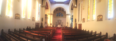 Ballarat Heritage Services
Photograph, Clare Gervasoni, Interior of Sacred Heart Kew, 01/03/2015
In 1872 membes of the Jesuits purchased land in Walpole Street. Three years later, on 14 Februrary 1875, Archbishop Gould laid a foundation stone for a school. By 1899 the land for the current church was purchased after mining speculator and Mt Lyell 'Copper King' James Crotty donated 3,000.00 pounds. The foundation stone was laid on 15 December 1918 by Archbishop Mannix. The cost of constructing the domed church was 15,000.00 pounds. A Fincham and Sons organ was installed in 1927, and refurbished in 1977. NEW PRESBYTERY AT KEW. Plans have been prepared by Mr. R. Harper, architect and builder, for the erection of a new presbytery for the Rev. P. Rafferty, adjoining the Sacred Heart Church, Cotham-road, Kew. The new building, which will be in brick and of two stories, will be behind the present priests' residence, which will continue to be used until the new presbytery is completed. The cost will be £6000, and the work will be begun almost immediately. The old presbytery was purchased many years ago by the late Rev. Fr. P. O'Donohue from the late Mr. Smart for £3000, and the full amount of the purchase money was donated by the late Mr. James Crotty. At different times additions were made to the building, but the small rooms made it altogether unsuitable as a residence for three priests, and made remodelling impracticable. The new presbytery will be in keeping with the Church of the Sacred Heart and the surroundings on the elevated site. At one time the old Sacred Heart Church was in Walpole-street, Kew. (The Advocate, 09 December 1937) The whole of the estate of the late Jas. Crotty has now been realised ex cepting 4000 shares in the Mount Lyell Company and a small parcel of general mining shares. All the debts and legacies, including £10,000 to St. Patrick's and £3300 to the testator's parish church at Kew, and also probate duty, have been paid. On present values the Mount Lyell shares. are worth a total of £37,000, and at the present rate of dividends the return represents an income of about £2000 per annum. Over and above this there is a sum of between £20,000 and £30,000 available for investment, and this, together with the dividends brings the income of the estate up to about £3000 per annum. A sum of £1100 per annum will be absorbed in annuities under the terms of the will. Whatever amount is realised beyond the sum necessary to pay the annuities goes to Archbishop Carr for the church and charitable purposes until the death of the last annuitant, when the resi duary estate will be divided between the Little Sisters of the Poor (North cote) and St. Joseph's Home (Surrey Hills). (Launceston Examiner, 18 July 1899) Sunday last being the anniversary of tire opening of the Sacred Heart Church, Kew, the pastor, Rev. Fr. Manly, made a special appeal at the various Masses. The beautiful design for marble altar for the Lady Chapel, which is on view in the vestibule, continues to attract attention. The Children of Mary Sodality have kindly undertaken to provide it, and the president, Miss Frances O'Sulliv!an, 43 Rideway-avenue, Kew, will be pleased to receive and acknow r ledge subscriptions from clients of Our Lady. They may also be placed in box near Lady Altar. (The Advocate, 06 December 1923)Panorama of the interior of Sacred Heart Catholic Church Kew. sacred heart, kew, catholic church -
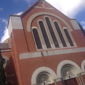 Ballarat Heritage Services
Photograph, Clare Gervasoni, Exterior of Sacred Heart Kew, 01/03/2015
In 1872 membes of the Jesuits purchased land in Walpole Street. Three years later, on 14 Februrary 1875, Archbishop Gould laid a foundation stone for a school. By 1899 the land for the current church was purchased after mining speculator and Mt Lyell 'Copper King' James Crotty donated 3,000.00 pounds. The foundation stone was laid on 15 December 1918 by Archbishop Mannix. The cost of constructing the domed church was 15,000.00 pounds. A Fincham and Sons organ was installed in 1927, and refurbished in 1977. NEW PRESBYTERY AT KEW. Plans have been prepared by Mr. R. Harper, architect and builder, for the erection of a new presbytery for the Rev. P. Rafferty, adjoining the Sacred Heart Church, Cotham-road, Kew. The new building, which will be in brick and of two stories, will be behind the present priests' residence, which will continue to be used until the new presbytery is completed. The cost will be £6000, and the work will be begun almost immediately. The old presbytery was purchased many years ago by the late Rev. Fr. P. O'Donohue from the late Mr. Smart for £3000, and the full amount of the purchase money was donated by the late Mr. James Crotty. At different times additions were made to the building, but the small rooms made it altogether unsuitable as a residence for three priests, and made remodelling impracticable. The new presbytery will be in keeping with the Church of the Sacred Heart and the surroundings on the elevated site. At one time the old Sacred Heart Church was in Walpole-street, Kew. (The Advocate, 09 December 1937) The whole of the estate of the late Jas. Crotty has now been realised ex cepting 4000 shares in the Mount Lyell Company and a small parcel of general mining shares. All the debts and legacies, including £10,000 to St. Patrick's and £3300 to the testator's parish church at Kew, and also probate duty, have been paid. On present values the Mount Lyell shares. are worth a total of £37,000, and at the present rate of dividends the return represents an income of about £2000 per annum. Over and above this there is a sum of between £20,000 and £30,000 available for investment, and this, together with the dividends brings the income of the estate up to about £3000 per annum. A sum of £1100 per annum will be absorbed in annuities under the terms of the will. Whatever amount is realised beyond the sum necessary to pay the annuities goes to Archbishop Carr for the church and charitable purposes until the death of the last annuitant, when the resi duary estate will be divided between the Little Sisters of the Poor (North cote) and St. Joseph's Home (Surrey Hills). (Launceston Examiner, 18 July 1899) Sunday last being the anniversary of tire opening of the Sacred Heart Church, Kew, the pastor, Rev. Fr. Manly, made a special appeal at the various Masses. The beautiful design for marble altar for the Lady Chapel, which is on view in the vestibule, continues to attract attention. The Children of Mary Sodality have kindly undertaken to provide it, and the president, Miss Frances O'Sulliv!an, 43 Rideway-avenue, Kew, will be pleased to receive and acknow r ledge subscriptions from clients of Our Lady. They may also be placed in box near Lady Altar. (The Advocate, 06 December 1923)Exterior of Sacred Heart Catholic Church Kew. sacred heart, kew, catholic church -
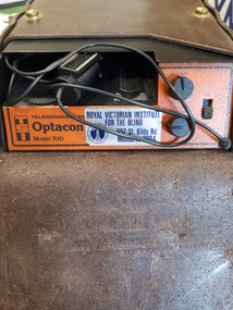 Vision Australia
Equipment - Object, Telesensory Systems, Optacon, 1974
The Optacon OPtical-to-TActile-CONverter is a compact, portable reading aid for the blind. It is about the size of a textbook, and weighs less than 2kg. It works by converting a printed image into a tactile image that a blind person can feel with one finger. After a period of training and practice, a blind person can use the Optacon to read ordinary books, magazines, newspapers, and other printed materials. The Optacon was developed after intensive research at Standford University, California, USA and was trialed by clients of the Royal Victorian Institute for the Blind (now part of Vision Australia) in 1973. It has three main sections: 1 a miniature camera, 2 an electronics section, and 3 a tactile stimulator array. The miniature camera, about the size of a pocket knife, is mounted in a housing that has rollers for easy movement along a line of print. The camera is connected to the electronics section by a lightweight cable. The electronics section and the tactile stimulator array are in the main chassis. The array consists of 144 tiny metal rods arranged in six vertical columns and 24 horizontal rows. Each of the rods can vibrate independently. The tips of these rods protrude through holes in a concave finger plate where the index finger is placed flat in order to read. These three components act together to convert the image of a printed letter or other shape into a pattern of vibrating rods, a tactile image of the letter or shape. The letter shape is tactually perceived as an image that moves from right to left on the finger, showing the left or leading edge of the letter first. Letters are felt sequentially rather than all at once, and the image should be kept moving. The Optacon converts a printed O into a tactile form that resembles a crater with a vibrating rim -- a completed circle. C would have a gap or opening on the right side of the curve. The letter F would be felt, sequentially, as a vertical line with two trailing horizontal lines. Because it can convert any ordinary printed image into a corresponding tactile image, the Optacon is not restricted to any special typestyle or language. The camera has a zoom lens that compensates for differences in the size of type. The standard Optacon lens can accommodate type sizes from 6 point to 20 point. With the optional F4A magnifier lens, type sizes as small as 4 point can be read. Powered by a rechargeable battery, and comes with its own battery charger. The battery is contained within the main chassis, and is not removable by the user. There are four basic controls on the Optacon: the Magnification Adjustment zoom button located on the camera section on the side opposite the rollers; and the On-Off switch, the Stimulator Intensity Adjustment knob, and the Threshold Adjustment knob located on the right side of the front panel. The Circuit Breaker protrudes from the right-hand wall inside the chassis compartment. From left to right when the back panel is facing you, are located: the jack for connecting the battery charger; the Battery Check button; the Normal-Invert switch; and the Input/Output I/O connector for use with the Visual Display, when using the Repeater Cable to connect two Optacons to one another or with other accessories. Designed not be removed from the leather case during normal operation, the On-Off switch is a slide switch located on the right side of the front panel. It slides up and snaps into place in the on position. 1 black with orange front, rectangular device in leather case assistive devices, audio equipment -
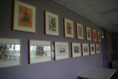 Federation University Art Collection
Print - Printmaking, Artwork from Dong Ho Village, c1970-2010
Dong Ho is on the Duong River in Bắc Ninh Province, Vietnam. The woodcut painting (Tranh khắc gỗ dân gian Dong Ho is a line of Vietnamese folk painting originating in Dong Ho village. The traditional themes of Dong Ho painting are good luck signs, historical figures, folk allegories, popular stories, and social commentaries. Elements of everyday life are well integrated in Dong Ho paintings to express the thoughts and wishes of people. (Wikipedia - https://en.wikipedia.org/wiki/%C4%90%C3%B4ng_H%E1%BB%93_painting, accessed 11 April 2017.) Craftsmen in Dong Ho use a special type of paper named giấy điệp. The bark of dó tree, which normally is grown in Tuyên Quang Province, is soaked in water for months, then mixed with powders of seashells (sò điệp), which is the origin of the paper's name, and glutinous rice to make sheets of paper. The s seashell and glutinous rice results in paper with an exotic sparkling hard background which is able to conserve the durability of colours. The colours are refined from natural materials which are easily found in Vietnam. For instance, the red colour is taken from red gravel in Thiên Thai Mountain, while the black comes from charcoal of burned bamboo leaves. The hand carved woodblock is applied with paint and pressed on a sheet of paper like a stamp. The process is repeated with different colours until the craftsman is satisfied with the outcome. One woodcut is for outline and several others are for each colour printed. The finished picture is covered with a layer of rice paste (hồ nếp) to strengthen the durability of its illustration and colours and afterwards dried under the sun. From beginning to end the process takes six to seven months. (Wikipedia - https://en.wikipedia.org/wiki/%C4%90%C3%B4ng_H%E1%BB%93_painting, accessed 11 April 2017.) The tradition of Đông Hồ painting dates back to the 11th century during the reign of the Lý Dynasty. Originally, Đông Hồ paintings were made with black-and-white prints of woodcuts, but from the 15th century, different colours were introduced by craftsmen in the village. As a village specialized in making woodcuts and paintings, almost all Đông Hồ villagers were involved in the manufacturing of paintings from carving the woodblocks, producing điệp papers, obtaining natural colours to creating new themes, and printing.(Wikipedia - https://en.wikipedia.org/wiki/%C4%90%C3%B4ng_H%E1%BB%93_painting, accessed 11 April 2017.) Before 1945 over 150 families in Đông Hồ village were making pictures, but the tradition has rapidly faded. Villagers can no longer make a living based on this production so only a few households in the village still make pictures, while many others have switched to producing joss paper and votive paper object.(Wikipedia - https://en.wikipedia.org/wiki/%C4%90%C3%B4ng_H%E1%BB%93_painting, accessed 11 April 2017.)Asian ArtA framed collection of work by children from Dong Ho Village, Vietnam.dong ho, vietnam, woodcut, printmaking, dong ho art, dong ho painting, dong ho village, vietnam. -
 Melbourne Legacy
Document - Speech, Foundation Day Address 1977. Legacy It's Beginnings. Past President Legatee Kem Kemsley
An article from the Bulletin including the text an address by Legatee Kem Kemsley at a Legacy event on 4 October 1977. He discusses the beginnings of Legacy. He starts with Legatee Savige's tip to Hobart and Sir John Gellibrand's Remembrance Club. Then a meeting of the 24th Battalion at Phair's Hotel in 1923 and the men there agreeing to start a similar club, he mentions Sandy Lowe as a member at the meeting in 1977 that was at the initial meeting in 1923. He also mentions other at that initial meeting were Savige, Frank Selleck, Ted Pittard, Bob Irving, and 'Babe' Norman. He relates the approach made to Sir John Monash to be the first president. It was when Savige was in Frank Meldrum's dentist chair that the plan was hatched for Meldrum, (who was playing tennis with Monash's son-in-law, Gershon Bennett), to approach Monash to be president. It shows the nature of relations between high ranking ex servicemen. Instead Monash suggested Colonel Harold Cohen. Initially Legacy was founded with 'one person from each profession or business who will represent that profession until such time as the Club has established itself on a wider basis.' For example there were 'two solicitors - Downing and Armstrong, Meldrum as dentist, George Worboys as plumber, Dr Gardener as the eye specialist, Doolan and Goodchild as Surveyors, Fred Wickham of the Premier's department who was regarded as very important, Baker from Myer's Emporium, Joynt from the printing world and Blackett the architect.' He also mentions a Police Strike and General Monash set up a special constabulary force. Cohen, Kemsley and many of the early legatees answered the call to help keep peace. By December 1923 there were 54 members of the new Legacy club. The name was under consideration as the Tasmanian club was called Remembrance Club. Pip Powell nominated the name of Legacy to be submitted for consideration, but it was Frank Selleck who moved the formal resolution. The speech mentions that Sir Gellibrand was appointed Patron of Legacy and later Monash and Sir Harry Chauvel were chosen. Frank Doolan posed the question 'what does Legacy really mean?' and focus changed toward widows and children. Citing some slightly different dates to those in a later speech about the start of Legacy (at 02029) he says it was July 1926 that they met with widows and a couple of weeks later 142 boys were to attend Anzac House for a Literary and Debating class. Ballarat and Geelong had formed clubs by 1925 and Legatee Hilmer Smith was transferred with his work to Sydney and started a Legacy Club there in 1926. The first Conference was held in November 1926. The first Government House Christmas party for children was held in 1926, when the Governor General of Australia was still residing there. His final words were about his war experiences and relates a speech made by Legatee Brian Armstrong on 28th February 1961 (02502) that also spoke of the area around the Pozieres Windmill that was part of the battle of the Somme in July/August 1916, where so many of the early legatees fought.. The article was part of an album of past presidents from 1965 to 1989. The folder included biographical details and obituaries, eulogies and death notices of prominent Legatees. The items have been catalogued separately.A record of a speech made by Legatee Kem Kemsley a past president of Legacy about events in the early days of Legacy. The information was collected to record the lives of prominent legatees in a folder.Photocopy of 5 pages from Bulletin on an address by Legatee Kem Kemsley in 1977.Bulletin 4.10.77. Page No 3, 4, 5, 6 and 7.past presidents, speech, foundation day, kem kemsley, sir john monash, pozieres, somme -
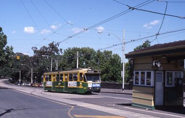
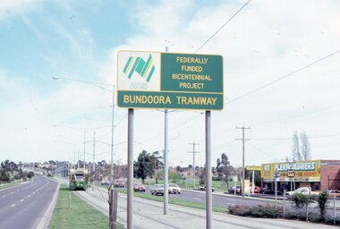 Melbourne Tram Museum
Album - Robert Thomson Slide Collection, "9.9.1988 to 16.9.1988", 9.9.1988 to 16.9.1988
Photo - see pdf file for further information. Number Brief Description RT055 Bundoora Extension - RT056 Bundoora Extension - tram 261 - "Special" route 00 RT057 Bundoora Extension - tram 86 - "Bundoora" route 86 RT058 St Kilda - Esplanade - Carlisle RT059 Relay - Danks St RT060 "City Brunswick St" - route 12 RT061 tram 1003 - "City Brunswick St"- route 12 RT062 track work on route 12 RT063 tram 774 - "City Brunswick St"- route 12 RT064 track work RT065 light rail - tram 2005 - "Depot" RT066 light rail - tram 273 - "Port Melbourne" - route 111 RT067 St Kilda Light Rail Station -tram 291- "St Kilkda Beach - route 06 RT068 St Kilda Rd - tram 830 - "City" - route 6 RT069 StKildaRd-tram928-"??"-route05 RT070 St Kilda - tram 272 - "East Brunswick" - route 96 RT071 Elizabeth St Terminus - tram 80 - "Ascot Vale" - route 9 RT072 West Coburg Reserved Track - tram 78 - "Domain & St Kilda Rds" - route 56 RT073 West Coburg Terminus - tram 66 - "Domain & St Kilda Rds" - route 56 RT074 West Coburg Terminus - tram 87 - "Domain & St Kilda Rds" - route 56 RT075 Batman Ave Terminus - tram 118 - "Wattle Park" - route 70 RT076 Collins St Terminus - tram 1022 - "West Preston" - route 11 RT077 North Balwyn Terminus - tram 255 - "City - Lonsdale St" - route 48 RT078 Kew Cotham Rd Terminus - tram 865 - "St Kilda Beach via Balaclava Rd" - route 69 RT079 St Kilda esplanade - Carlisle - tram 946 - "Kew Cotham Rd" - route 69 - tram 295 - "East Brunswick" - route 96 RT080 West Preston Terminus - tram 943 - "St Kilda Beach" - route 10 RT081 Mont Albert Terminus - tram 250 - "Mont Albert" - route 42 RT082 Carnegie Single Line - tram 998 - "City" - route 67 RT083 Carnegie Single Line - tram 736 - "Carnegie" - route 67 RT084 Carnegie terminus - tram 736 - "City" - route 67 RT085 East Brighton Terminus - tram 914 - "City" - route 64 RT086 St Kilda Jct - tram 998 - "East Malvern Darling Rd" - route 3 & tram 969 - "City" route 3 RT087 Bourke St Spencer St - tram 271 - "St Kilda Beach" - route 96 RT088 Preston Railway Overbridge - "Northcote via St Georges Rd" - route 9 RT089 Victoria Parade - tram 906 - "Mont Albert" - route 42 & tram 252 - "City" - route 42 RT090 Victoria Parade - tram 1025 - "City Spencer St" - route 31Demonstrates the work of Robert Thomson in photography, collection and/or production of slidesAssembled album in a black presentation folder of 36 colour slides, collected or produced by Robert Thomson. All photographs have been scanned and placed on the Museum's G drive. A list of all photographs with details has been compiled. melbourne, tramways, trams, track construction -
 Melbourne Tram Museum
Album - Robert Thomson Slide Collection - box 17, 1999 to 2001
Photo - see pdf file for further information. Number Date Brief Description Box 17 RT396 Nov. 99 A 239 arriving Batman Ave Route 70 RT397 Nov 99 W7 1012 running Special, Clarendon St RT398 Nov 99 A 300, Port Melbourne, Mont Albert route 109 RT399 Nov 99 A 286 Port Melbourne line, route 109 RT400 Nov 99 Z3 223 Carlisle St St Kilda, route 69 – with destination set for return Kew Cotham Road RT401 Nov 99 W7 1005 Swanston St route 8 with Christmas decorations – route 8 RT402 Nov 99 Z3 140 Swanston St route 8 with Christmas decorations – route 11 RT403 Nov 99 Z3 144 Swanston and Bourke with “Give way to passengers ”sign – route 1 RT404 Nov 99 Z3s 144 and 196 Swanston St – with sign “Tram stop ahead” RT405 Nov 99 W6 977 Swanston St – route 8 and Z1 72 RT406 Nov 99 11W and City Circle SW5 723 – Spencer and Collins Sts RT407 Nov 99 SW6 960 University terminus, route 16 RT408 Nov 99 SW6 960 University terminus with Z2 108 and other trams RT409 Nov. 99 A 234 Wattle Park terminus, route 70 RT410 Nov 99 New track docklands with old shipping shed in the view. RT411 Nov 99 Flinders St extension Docklands new track RT412 Nov 99 A 255 route 109 Port Melbourne terminus with former station building RT413 Nov 99 SW6 954 Route 16, Ackland St terminus with a Z3 behind. RT414 Nov 99 Restraurant tram 442, Esplanade. RT 415 Nov 2000 Z27 and Z1 Balaclava Junction RT416 Nov 2000 A 278 route 109 Port Melbourne terminus with former station building RT417 Nov 2001 B2 2010 in Yarra livery, Bourke St at Spencer St RT418 Nov 2001 B2 2108 turning from Bourke into Spencer St (route 96) followed by another B2 2048? RT 419 Nov 2001 Z 80 and another two Zs in Swanston St RT420 Nov 2001 Z137 and other Z’s in Swanston St RT421 Nov 2001 Z82 Swanston st RT422 Nov 2001 Z3 169 Wests Road, West Maribyrnong terminus with another Z arriving. Route 57 RT423 Nov 2001 West Maribyrnong terminus board with Swanston Trams signage RT424 Nov 2001 Z3 172 route 82, Wests Road RT425 Nov 2001 A class Flinders St extension route 48 in Yarra Trams livery RT426 Nov 2001 11W Bourke St with MTOCco building in the background. Demonstrates the work of Robert Thomson in photography, collection and/or production of slidesAssembled album in a black presentation folder of 31 colour slides, collected or produced by Robert Thomson. A list of all photographs with details has been compiled. All rights reserved for all photos., melbourne, tramways, trams, tram 239, route 70, batman ave, tram 1012, clarendon st, tram 300, port melbourne, route 109, tram 223, tram 69, tram 1005, route 8, swanston st, tram 140, tram 144, tram 196, tram 977, tram 72, tram 11w, tram 723, city circle, tram 960, tram 108, tram 234, wattle park, docklands, trackwork, flinders st, tram 255, tram 954, tram 442, tram 27, tram 1, tram 278, tram 2010, tram 2108, tram 80, tram 137, tram 82, tram 169, wests road, west maribyrnong, swanston trams, tram 172, route 82, route 48, bourke st, mtoco -
 Clunes Museum
Work on paper - FAMILY HISTORY BENJAMIN WHITE
BENJAMIN AND SARAH WHITE ARE RECORDED IN "SOUTH AUSTRALIANS 1836-1885" BOOK TWO.DESMA FAY NICHOLSON OF 160 FRANCIS ST RICHMOND NSW PROVIDED THE INFORMATION FOR THE BOOK. DESMA IS A DESCENDENT OF JOHN WHITE, FIFTH AND YOUNGEST SON OF BENJAMIN WHITE BENJAMIN WHITE PARENTS BENJAMIN AND JANE (NEE LOWDEN- SHOULD BE SOWDEN) BORN 1819 CAMBORNE, CORNWALL DIED JAN 1874 VICTORIA, BURIED IN CRESWICK ARRIVED SA 29/10/1847 FROM ENGLAND ON DUCHESS OF NORTHUMBERLAND DEPARTED SA C. 1852 FOR VICTORIA OVERLAND OCCUPATION MINER AND SECTON RESIDENCE: KAPUNDA ALLENS CREEK SA RELIGION: WESLEYAN HE MARRIED SARAH (SALLY) BAILEY ON 02/08/1845 IN CAMBORNE ENGLAND, SHE DIED 12/08/1891 IN CRESWICK CHILDREN: SARAH ANNE WILLIAMS 07/09/1845 TO 18/06/1890 ELIZABETH ORRINGE 22/02/1847 TO 16/10/1920 BENJAMIN 22/04/1849 TO 19/02/1889 HARRIET 29/08/1850 TO 15/05/1851 WILLIAM BAILEY 22/10/1851 TO 14/03/1916 JOSEPH 20/11/1853 TO 17/05/1910 THOMAS HENRY 15/05/1855 TO 15/08/1917 JOHN 14/04/1857 TO 27/02/1935 HARRIET 17/01/1860 TO 14/06/1863 DECIMA JANE CHEGWYN 04/01/1862 TO 28/02/1940 EMILY WILSON 07/03/1864 TO 19/08/1937 BENJAMIN WHITE MARRIED SARAH BAILEY IN CORNWALL IN SEPTEMBER 1845, JUST ONE MONTH BEFORE THE BIRTH OF THEIR FIRST CHILD SARAH ANN. SECOND CHILD ELIZABETH WAS BORN IN MARCH 1847 JUST SIX MONTHS BEFORE THE FAMILY SAILED FOR SOUTH AUSTRALIA ON THE NORTHUMBERLAND. THE MANNING INDEX OF SOUTH AUSTRALIAN HISTORY REC9ORDS THAT BENJAMIN WHITE WAS RESPONSIBLE FOR "CREATING" THE ALLEN CREEK VILLAGE 5 KM NORTHWEST OF KAPUNDA C. 1849. CERTAINLY AT ONE STAGE BENJAMIN HAD A CONSIDERABLE LAND HOLDING ADJACENT TO ALLEN'S CREEK VAL LAWRENCE SUGGESTS THAT THE WHITE FAMILY TRAVELLED BY SEA FROM SA TO VICTORIA, NOT OVERLAND AS SUGESTED BY DESMA NICHOLSON IN "SOUTH AUSTRALIANS 1836-1885 ACCORDING TO CRSWICK HOSPITAL RECORDS BENJAMIN WHITE WAS ADMITTED JUNE 27 1873 (AGE 49 MARRIED, GRAVEDIGGER AT CRESWICK, BORN IN ENGLAND, WESLEYAN) AND LEFT HOSPITAL JULY 14 1873. A CHRONICALLY ILL CONDITION WAS RELIEVED. BENJAMIN WHITE DIED DECEMBER 22, 1873. A SPECIAL CHURCH SERMON WAS CARRIED OUT ON SUNDAY JANUARY 43 1874benjamin white, sarah white, sarah bailey -
 Bendigo Historical Society Inc.
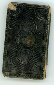
Book - HOSKING AND HUNKIN COLLECTION: BIBLE, 1800s
HOSKING AND HUNKIN COLLECTION: Small Bible inside envelope. On Binder: New Testament Inside front cover: This Book Belongs to Ellen Nancarrow November 8th 1857 Redruth Coomb Inside second page: This is a present given to Emily Hoskong by her Aunt Helen a a token of Love November 1860. Bible Details: The New Testament of our Lord and Saviour Jesus Christ translated out of the original Greek and with the former translations diligently compared and revised, by his Majestiy's special Command appointed to be read in Churches. Oxford prineted at the Univerity Press for the British and Froreign Bible Society, instituted in London in the year 1804; and sold to Subscribers at the Society house Earl Street, Blackfriers, London. Diamond's 48's 1856. Cum Privilegio Note inside BibleBible given to Emily Hosking (m. Emmanuel Hunkin) from her aunt Ellen (Nancarrow) Redruth Coomb. 8 Nov 1860 prior to sailing to Victoria. Nancarrow = Valley of the Stags. On front of envelope: Her New Testament a precious possesion. Bible given to Emily Hosking (b. 12-2-1854 d. 22-5-1905) by her mother's sister Ellen Nancarrow (b 17 Mar 1827 husband Wm Hosking m. 1853 Rev. John Cornwall Wm. D. 10 July 1914) in 1860 8th Nov before leaving for Australia. Liven and mined at Eaglehawk, Vic. Then Rushworth area (farming) Emblen Hosking nee Nanacarrow RedruthCoomb Cornwall b. 6/3/1831 d. 20/5/1895 Gobarup. Rear of envelope: Yellow and black stickers (Women with flowers and Man with Scythe, and St. Piran's) written on 'Cornish Patron Saint's day - 5th March. Address Label: Ms Betty Night, 29 Gilbertson Street Essendon Vic 3040 Separate page of Notes: A note in the front of Hymn Book Emily Hosking born 12/2/1854 married 1873 her book. A reward - The Bible Christian Sabbath School, Sailors Gully June 29th 1868. Hyms - Bible Christian 2nd edition 1890. Bible Christian Book Room 26 Paxxxx Road E.C. Mrs E. Hunkin Eaglehawk B.C. Church January 21st (18) 94 Husband Emmanuel Huskin born 21/1/1852 - collection of hymns Wesley hymns Emmanuel Hunkin. 2. A collection of hymns Emmanuel Hunkin, Eaglehawk Bendigo.book -
 Eltham District Historical Society Inc
Photograph, Fay Bridge, Moor-rul Viewing Platform, Garden Hill, Kangaroo Ground, n.d
OPENING OF THE VIEWING PLATFORM AT KANGAROO GROUND Nillumbik Council has advised that the viewing platform at Kangaroo Ground 27km NE of Melbourne is to be opened to the public on Wednesday, March 26th 2008 (Melway 271 , G10). The function of the platform is to provide shelter adjacent to the War Memorial Tower whilst allowing all people to enjoy the stunning panoramic views. From the platform you. can see the Dandenongs, the city of Melbourne, the You Yangs, Mount Macedon, the Kinglake Ranges and the Mt Baw-Baw Ranges where the Yarra River starts. This landscape covers all the ancestral lands of the Wurundjeri and some of the wider Kulin nation land. The platform has been given the name Moor-rut, a name which described the fertile soils of the Kangaroo Ground area in contrast to the poorer (Silurian) country of its surrounds, which the Wurundjeri knew as 'Nillumbik' or less rich country. The full 360 degree view can be seen from the adjacent Tower of Remembrance which has 53 stairs. The viewing platform however can be accessed by wheelchair. Inside the viewing platform there are eight double sided interpretive panels giving the history and information regarding this special area. The viewing platform's interpretive panels set out the Aboriginal and European history of the area and also the geology and the local flora and fauna, so that the casual visitor comes away understanding more about this significant part of Victoria. The concept of the viewing platform is part of the refurbishment project for the Kangaroo Ground War Memorial Park which has taken place since 1997 with the active approval and financial assistance of the Nillumbik Shire Council. This project has been guided by an Advisory Committee with volunteer community representatives from the local Historical Societies, the Country Fire Authority, the Returned Services League and the Wurundjeri people. Other allied groups such as the Nillumbik Reconciliation Group have been called upon for their expertise. The initial idea for the viewing platform came from Dean Stewart when he was the caretaker while living at the park. He discussed this idea with local author Mick Woiwod and Harry Gilham of Eltham District Historical Society when they were planning the refurbishment of the War Memorial Park in 1996. When the committee was formalised by the Nillumbik Council in 1997, Nicholas Pelling, representing the CFA and RSL, joined the group. Dennis Ward, local architect, then volunteered to develop the concept plan for the refurbishment of the park and later drew up the plans for the viewing platform. The Kangaroo Ground War Memorial Park and its Tower of Remembrance is located on one of the highest locations in the Yarra Valley. The Tower of Remembrance is a unique war memorial constructed from local stone standing 14 metres high. It was built in the style of a Scottish watchtower reflecting the strong Scottish influence of the first European settlers of the district from the 1840s onward. The park was opened in 1921 and the Tower of Remembrance was dedicated in 1926 recognising the local people who served in the First World War. Those who served in the Second World War were recognised by plaques dedicated in 1951 and more recently those who served in Korea, Borneo, Malaya and Vietnam by plaques unveiled in 2001. Harry Gilham, Advisory Committee Convenor - Eltham District Historical Society Newsletter N0 179 March 2008fay bridge collection, garden hill, kangaroo ground, memorial park, moor-rul viewing platform -
 Eltham District Historical Society Inc
Photograph - Black and White Print, Moor-rul Viewing Platform, March 2007
Early stages - no display panels installed. OPENING OF THE VIEWING PLATFORM AT KANGAROO GROUND Nillumbik Council has advised that the viewing platform at Kangaroo Ground 27km NE of Melbourne is to be opened to the public on Wednesday, March 26th 2008 (Melway 271 , G10). The function of the platform is to provide shelter adjacent to the War Memorial Tower whilst allowing all people to enjoy the stunning panoramic views. From the platform you. can see the Dandenongs, the city of Melbourne, the You Yangs, Mount Macedon, the Kinglake Ranges and the Mt Baw-Baw Ranges where the Yarra River starts. This landscape covers all the ancestral lands of the Wurundjeri and some of the wider Kulin nation land. The platform has been given the name Moor-rut, a name which described the fertile soils of the Kangaroo Ground area in contrast to the poorer (Silurian) country of its surrounds, which the Wurundjeri knew as 'Nillumbik' or less rich country. The full 360 degree view can be seen from the adjacent Tower of Remembrance which has 53 stairs. The viewing platform however can be accessed by wheelchair. Inside the viewing platform there are eight double sided interpretive panels giving the history and information regarding this special area. The viewing platform's interpretive panels set out the Aboriginal and European history of the area and also the geology and the local flora and fauna, so that the casual visitor comes away understanding more about this significant part of Victoria. The concept of the viewing platform is part of the refurbishment project for the Kangaroo Ground War Memorial Park which has taken place since 1997 with the active approval and financial assistance of the Nillumbik Shire Council. This project has been guided by an Advisory Committee with volunteer community representatives from the local Historical Societies, the Country Fire Authority, the Returned Services League and the Wurundjeri people. Other allied groups such as the Nillumbik Reconciliation Group have been called upon for their expertise. The initial idea for the viewing platform came from Dean Stewart when he was the caretaker while living at the park. He discussed this idea with local author Mick Woiwod and Harry Gilham of Eltham District Historical Society when they were planning the refurbishment of the War Memorial Park in 1996. When the committee was formalised by the Nillumbik Council in 1997, Nicholas Pelling, representing the CFA and RSL, joined the group. Dennis Ward, local architect, then volunteered to develop the concept plan for the refurbishment of the park and later drew up the plans for the viewing platform. The Kangaroo Ground War Memorial Park and its Tower of Remembrance is located on one of the highest locations in the Yarra Valley. The Tower of Remembrance is a unique war memorial constructed from local stone standing 14 metres high. It was built in the style of a Scottish watchtower reflecting the strong Scottish influence of the first European settlers of the district from the 1840s onward. The park was opened in 1921 and the Tower of Remembrance was dedicated in 1926 recognising the local people who served in the First World War. Those who served in the Second World War were recognised by plaques dedicated in 1951 and more recently those who served in Korea, Borneo, Malaya and Vietnam by plaques unveiled in 2001. Harry Gilham, Advisory Committee Convenor - Eltham District Historical Society Newsletter N0 179 March 2008 Black and white inkjet print on paper 14 x 21 cmmoor-rul viewing platform, garden hill, kangaroo ground, memorial park -
 Eltham District Historical Society Inc
Photograph, Upper Yarra Dam, Spring Tour, 22 Oct 1995, 22/10/1995
EXPLORING THE UPPER YARRA (Newsletter No. 105, November 1995, by Bettina Woodburn) We enjoyed the Spring Excursion, this year "Exploring the Upper Yarra" - in spite of the constant rain and the countryside under the cloud cover, especially in the valleys, being mainly shiny shades of green. The occasional fields of buttercups, clumps of arum lilies and splendid rhododendron and other flowering bushes became very special. The Cobb and Co coach was warm and a cosy retreat as we zig-zagged on the highways and byways to glimpse the Yarra River, upstream and down, its secret places, and particularly the many bridges. Russell excelled as 'Poet Laureate', reading from Dacre Smyth's book. This 1979 publication includes paintings of all the bridges along the river with poems and brief descriptions of each one. Some of the bridges are in out of the way places and are not very well known. We looked forward to hearing the poetry as much as seeing the ' constructions'…Big Pat (was he short or tall, lean or fat? He did win the two hundred pound reward for discovering gold and had the creek named after him), about the 'Eddies'?, and the disliked 'meccano' bridge in Warburton, etc. etc. The hot roast lunch in the old Reefton Hotel was also most welcome. It was easy to imagine it peopled by miners and early settlers. Starting by crossing the new (1974) concrete bridge at Warrandyte we headed through Wonga Park with views to the Christmas Hills and to the escarpment of the Yering Gorge, which causes flood waters to back up through the Yarra Glen plain, so avoiding disasters downstream. At the end of a long driveway we found the wooden, privately owned Henley Bridge (1935 after the 1934 floods). This facilitates access to different parts of Henley Farm and to Lilydale. Everard Park, named after Blanche Shallard's father, a State Member for 17 years, below the Highway Yarra crossing was in need of care. It is 10 miles from Yarra Glen by road but, as "Yarra Marra” canoeists well know, 32 winding miles down by water. After more delightful countryside scenes we joined the Warburton Highway at Woori Yallock. From the old Railway Station at Launching Place the Centennial Trail for walkers, cyclists and ' horse riders has replaced the rails. The line from Lilydale was opened in 1901, and the last diesel freight train ran to Warburton in 1965. It continued to rain as we had morning tea in Warburton in a shelter between footbridges. From here we continued upstream past the Bridge to O'Shannasy Lodge and Reservoir, Starvation Creek, and the Peninsular tunnel (miners dug it as at Pound Bend) which we visited (scrambling down those steps!) on our return after lunch. Our furthermost point was the Upper Yarra Dam Reserve (and vast catchment area). Finished in 1957 after ten years work and 100 years after Yan Yean, it supplies much of Melbourne's water. After crossing the 30m Launching Place Bridge to the Eltham side of the Yarra and Healesville, we saw in the distance the Yarra Glen Timber Trestle Bridge over the river flats "the longest for years in the land it was said!" Harry's dream of "better weather over the Divide" unfortunately didn't come true, but I'm sure we 36 members will retain happy memories of a day that was wet and green and filled with Bridges. Bettina Woodburn - October 1995 Record of the Society's history of activities - Spring 1995 excursionColour photographshire of eltham historical society, activities, upper yarra dam, henley bridge -
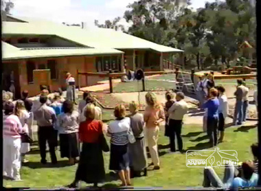 Eltham District Historical Society Inc
Film - Video (VHS), VideoCAM, Eltham Woods Children's Resource Centre Opening (Series 69, Item 5), 5 Mar 1988
Shire of Eltham Archives: Series 69, Item 5 Video opens with panning view of completed kinder from Frank Street followed by images of the centre under construction then opening day speeches. Introduction and welcome by Mandy Press (Executive Officer, Shire of Eltham) with speeches by the Hon. Pauline Toner, Member for Eltham and Shire president, Cr. Alan Baker. The Hon. Pauline Toner acknowledged Shire President Alan Baker and her parliamentary colleagues Vin Heffernan, Neil Brown and Bob Halderson and Councillors; three levels of Government which led to the achievement of the kinder, and gave special thanks to the Council and parents for the forward planning to accommodate children from babyhood to school with childcare, kinder and baby health facilities all combined in one facility in the middle of parkland in a residential area. Shire President Cr Alan Baker then followed to formally open the centre. The site had been identified in early 1985 at that stage only as a pre-school but with an opportunity to develop, the additional services were driven by Cr Baker. Though a very long name, its simple message is "Care for Kids." Designed by architect Neil Biggins of Clark, Hopkins and Clark. Cr Baker stated that the theme of "people living in the environment" was very much encapsulated by the facility. Cr Baker informed that the construction of the facility had led to some concerns with a reduction in open space and potential traffic generated to the facility and those users of the facility were asked to ensure their use is sensitive to the local residents. Cr Baker talked about the financial costs and how the Federal grant funding was no longer as plentiful as previous and that the Victorian Government had come to the assistance thanks to Pauline Toner covering some other costs as well as the ongoing running costs of around $40,000. The Federal Government contributed $233,000 out of a childcare component rather than preschool. Cr Baker thanked Mandy Press again as well as Shire Engineer, John Stanton. Cr Baker also acknowledged Ed Latanzio who was in charge of the project, along with his colleague Alan Lansdowne; Gary Bartlett and his team for the exterior surroundings to the facility. He mentioned that Neil Biggins the architect had said not many Shire Councils show the same commitment to the exterior surroundings as the interior which was a credit to the Council and Gary Bartlett. He also thanked Bev Vern, Council's preschool advisor who assisted in developing the programs; Grant Roberts from Federal Office of Childcare for assisting the Cooperative in setting up the funding program; the builders George Takola and George Apted; Michelle Matello who undertook the needs analysis that identified another preschool was required; Cathy King who assisted in the development of the childcare program; Pat Grundy and Susan Forbes, Council officers who assisted with the development of the services and the members of the preschool committee. In addition, local residents and in particular Helen, Peter and Chris who advised Council of their concerns and worked with Council to overcome these issues; members of the Interim Steering Committee and the Directors of the Childcare Co-op. Cr Baker stated that the Co-op nature of the facility and the location of the three services under one roof was unique and the task of the programs was to be led by Annie, Dianne and Lynn Afternoon tea and activities followed the unveiling of the plaque. The video shows some of the children's entertainment and their engagement as well as interior and exterior views.VHS Video cassette Converted to MP4 file format 00:26:02; 302MBshire of eltham, video recording, shire of eltham archives, eltham shire council, alan lansdowne, bev vern, bob halderson, cathy king, clark hopkins and clark, councillors, cr. alan baker, ed latanzio, eltham, eltham woods childcare co-operative, federal government, federal office of childcare, frank street, gary bartlett, george apted, george takola, grant roberts, john stanton, mandy press, michelle matello, neil biggins, neil brown, pat grundy, pauline toner, people living in the environment, susan forbes, victorian government, vin heffernan -
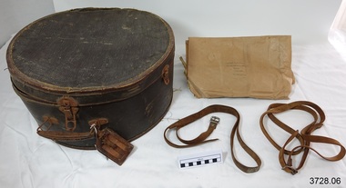 Flagstaff Hill Maritime Museum and Village
Functional object - Hat box, early to mid-20th century
This large hat box was owned by Miss Katherine Robertson (now deceased). It was sold by Drews, a leather and travel goods shop in Melbourne, and has been made as good quality, sturdy travel luggage. It has its own leather luggage label buckled to the handle and there are remnants of labels on the base of the hat box, signifying that it has indeed been used as luggage. A hat box such as this one is made to protect, store and transport head wear. Hat boxes became popular in the 19th and early 20th century when hats were a part of the modern fashion. Inside the hat box is a brown paper wrapper with two Great Britain postage stamps attached. Both have the portrait image of Queen Elizabeth II (1) orange 1/2d (2) green ten pence. These stamps belong to the Wildings series and were issued 1952-1954. The wrapper was sent by J McGregor in Glasgow, Scotland to Katherine Robertson in Sale, Victoria. The postmark stamp shows it was sent in 1955. The paper had once been folded around something rectangular in shape, perhaps a book. The hat box was recently found by Archie’s daughter, niece of Katherine, when she was looking for something else in the ceiling of her home. The hat box had been there, with the brown paper wrapper inside, for about 30 years, forgotten by the family. There are no family members remaining now to tell the full story. ABOUT MISS KATHERINE ROBERTSON The Robertson family emigrated from the Isle of Wight and settled in Woorndoo, Western Victoria, Australia. Katherine Robinson was the 10th child of 13 children, born in 1906 and lived until 1995. The youngest child in the family was a boy named Archibald (Archie) who was born in 1911. His daughter is the donor of the hat box. Katherine went to school at Woorndoo and later became a trained teacher. She taught in many places, amongst them were Alexandria, Geelong, Sale, Stawell and Ballarat. People said “She was a school teacher 24 hours a day!” She was insistent on being called Miss Katherine Robinson, and no-one dare call her a shortened name in any way, not Kate, or Katie or even Kathie. She spoke with the authority of a teacher throughout her life, never asking but always giving her requests as orders. Miss Katherine Robinson remained single all her life. She bought items that were the best quality and workmanship, which gives reason for the strong and well-travelled hat box. She enjoyed going on trips and travelled the world twice. While on her journeys Katherine would knit Fair Isle patterned socks using fine 4 ply wool because she “Didn’t believe in wasting time!” Katherine’s niece remembers being in Melbourne at Station Pier, seeing her Aunt off on one of her journeys. She recalls the atmosphere and the colourful streamers in the air that celebrated the special occasion. Katherine travelled on the Oriana and Fair Star lines. ABOUT DREWS Drew’s, Leather Goods Specialists, was located at 70 Swanston St, corner of Queen’s Walk, Melbourne, at the time that this hat box was sold by the company. Queen’s Walk was constructed in 1889. It was a lavish ‘L’ shaped arcade that connected Swanston Street to Collins Street and was home to many specialist stores. In the 1950’s Drews address was advertised as Collins Street. In the late 1960’s Queen’s Walk was purchased by the Melbourne City Council and demolished in the early 1970’s, to be replaced by the Melbourne City Square. This very sturdy and good quality hat box is an example of travel luggage available to and used by the Victorian population of Australia in the early to mid-20th century. The retailer of this hat box, Drews, operated from premises on the corner of Swanston St and Queen’s Walk in Melbourne where many other specialist shops were located. Queen’s Walk was only in existence for around 70 years, 1889-late 1960, before it was demolished to make way for Melbourne’s City Square. Hat box, large, deep round shape with a straight section where lid is joined on at the back. Dated early to mid-1900’s. Brown coloured, textured heavy weight card box with folding metal carry handle, three clip closures for lid, metal hinge on back of lid. Purple maker’s label inside lid - DREWS, Leather Goods Specialists, Melbourne. Leather luggage tag has two rectangular cut-outs on front, attached with buckle strap. Underside of lid has two supporting leather straps attached to base. Base has inner cardboard liner around most of circumference. Contained inside are two leather straps with metal buckles. Label remnants, red, attached under base. Hat box was owned by Miss Katherine Robertson. Also inside is brown paper wrapper with three hand written addresses, in blue nib pen, and two attached Great Britain postage stamps, Queen Elizabeth II (1) Orange stamp, QE II, ½d (2) Green stamp, QE II, ten pence. It is postmarked [19] 55. Purple label has printing "70 SWANSTON STREET / Cr. QUEEN'S WALK / DREWS / LEATHER GOODS / SPECIALISTS / MELBOURNE". Wrapper inside has two hand written addresses (1J) Mrs. K. F. Robertson / 33 Mcalister Street / Sale / Victoria / Australia” (2) “from / J Mc Gregor / 15 Napier’s Hall St / Glasgow N W / Scotland” Postmark “ - -em 55” & “CLAS-“ OR “GLAS-“ [GLASGOW] flagstaff hill, warrnambool, shipwrecked coast, flagstaff hill maritime museum, maritime museum, shipwreck coast, flagstaff hill maritime village, great ocean road, luggage, hat box, hatbox, hat storage box, hat travel case, hat case, bandbox, drews melbourne, drew’s melbourne, drew’s handbags, travel goods, travel luggage, hat box suitcase, hat box luggage, 1952-1954 gb postage stamps 1/2d orange queen elizabeth ii, katherine robertson, archibald (archie) robertson of woorndoo, j mcgregor -
 Eltham District Historical Society Inc
Photograph, Upper Yarra Dam, Spring Tour, 22 Oct 1995, 22/10/1995
EXPLORING THE UPPER YARRA (Newsletter No. 105, November 1995, by Bettina Woodburn) We enjoyed the Spring Excursion, this year "Exploring the Upper Yarra" - in spite of the constant rain and the countryside under the cloud cover, especially in the valleys, being mainly shiny shades of green. The occasional fields of buttercups, clumps of arum lilies and splendid rhododendron and other flowering bushes became very special. The Cobb and Co coach was warm and a cosy retreat as we zig-zagged on the highways and byways to glimpse the Yarra River, upstream and down, its secret places, and particularly the many bridges. Russell excelled as 'Poet Laureate', reading from Dacre Smyth's book. This 1979 publication includes paintings of all the bridges along the river with poems and brief descriptions of each one. Some of the bridges are in out of the way places and are not very well known. We looked forward to hearing the poetry as much as seeing the ' constructions'…Big Pat (was he short or tall, lean or fat? He did win the two hundred pound reward for discovering gold and had the creek named after him), about the 'Eddies'?, and the disliked 'meccano' bridge in Warburton, etc. etc. The hot roast lunch in the old Reefton Hotel was also most welcome. It was easy to imagine it peopled by miners and early settlers. Starting by crossing the new (1974) concrete bridge at Warrandyte we headed through Wonga Park with views to the Christmas Hills and to the escarpment of the Yering Gorge, which causes flood waters to back up through the Yarra Glen plain, so avoiding disasters downstream. At the end of a long driveway we found the wooden, privately owned Henley Bridge (1935 after the 1934 floods). This facilitates access to different parts of Henley Farm and to Lilydale. Everard Park, named after Blanche Shallard's father, a State Member for 17 years, below the Highway Yarra crossing was in need of care. It is 10 miles from Yarra Glen by road but, as "Yarra Marra” canoeists well know, 32 winding miles down by water. After more delightful countryside scenes we joined the Warburton Highway at Woori Yallock. From the old Railway Station at Launching Place the Centennial Trail for walkers, cyclists and ' horse riders has replaced the rails. The line from Lilydale was opened in 1901, and the last diesel freight train ran to Warburton in 1965. It continued to rain as we had morning tea in Warburton in a shelter between footbridges. From here we continued upstream past the Bridge to O'Shannasy Lodge and Reservoir, Starvation Creek, and the Peninsular tunnel (miners dug it as at Pound Bend) which we visited (scrambling down those steps!) on our return after lunch. Our furthermost point was the Upper Yarra Dam Reserve (and vast catchment area). Finished in 1957 after ten years work and 100 years after Yan Yean, it supplies much of Melbourne's water. After crossing the 30m Launching Place Bridge to the Eltham side of the Yarra and Healesville, we saw in the distance the Yarra Glen Timber Trestle Bridge over the river flats "the longest for years in the land it was said!" Harry's dream of "better weather over the Divide" unfortunately didn't come true, but I'm sure we 36 members will retain happy memories of a day that was wet and green and filled with Bridges. Bettina Woodburn - October 1995 Record of the Society's history of activities - Spring 1995 excursionRoll of 35mm colour negative film, 3 stripsKodak Gold 200-4shire of eltham historical society, activities, upper yarra dam, henley bridge -
 Eltham District Historical Society Inc
Photograph, Upper Yarra Dam, Spring Tour, 22 Oct 1995, 22/10/1995
EXPLORING THE UPPER YARRA (Newsletter No. 105, November 1995, by Bettina Woodburn) We enjoyed the Spring Excursion, this year "Exploring the Upper Yarra" - in spite of the constant rain and the countryside under the cloud cover, especially in the valleys, being mainly shiny shades of green. The occasional fields of buttercups, clumps of arum lilies and splendid rhododendron and other flowering bushes became very special. The Cobb and Co coach was warm and a cosy retreat as we zig-zagged on the highways and byways to glimpse the Yarra River, upstream and down, its secret places, and particularly the many bridges. Russell excelled as 'Poet Laureate', reading from Dacre Smyth's book. This 1979 publication includes paintings of all the bridges along the river with poems and brief descriptions of each one. Some of the bridges are in out of the way places and are not very well known. We looked forward to hearing the poetry as much as seeing the ' constructions'…Big Pat (was he short or tall, lean or fat? He did win the two hundred pound reward for discovering gold and had the creek named after him), about the 'Eddies'?, and the disliked 'meccano' bridge in Warburton, etc. etc. The hot roast lunch in the old Reefton Hotel was also most welcome. It was easy to imagine it peopled by miners and early settlers. Starting by crossing the new (1974) concrete bridge at Warrandyte we headed through Wonga Park with views to the Christmas Hills and to the escarpment of the Yering Gorge, which causes flood waters to back up through the Yarra Glen plain, so avoiding disasters downstream. At the end of a long driveway we found the wooden, privately owned Henley Bridge (1935 after the 1934 floods). This facilitates access to different parts of Henley Farm and to Lilydale. Everard Park, named after Blanche Shallard's father, a State Member for 17 years, below the Highway Yarra crossing was in need of care. It is 10 miles from Yarra Glen by road but, as "Yarra Marra” canoeists well know, 32 winding miles down by water. After more delightful countryside scenes we joined the Warburton Highway at Woori Yallock. From the old Railway Station at Launching Place the Centennial Trail for walkers, cyclists and ' horse riders has replaced the rails. The line from Lilydale was opened in 1901, and the last diesel freight train ran to Warburton in 1965. It continued to rain as we had morning tea in Warburton in a shelter between footbridges. From here we continued upstream past the Bridge to O'Shannasy Lodge and Reservoir, Starvation Creek, and the Peninsular tunnel (miners dug it as at Pound Bend) which we visited (scrambling down those steps!) on our return after lunch. Our furthermost point was the Upper Yarra Dam Reserve (and vast catchment area). Finished in 1957 after ten years work and 100 years after Yan Yean, it supplies much of Melbourne's water. After crossing the 30m Launching Place Bridge to the Eltham side of the Yarra and Healesville, we saw in the distance the Yarra Glen Timber Trestle Bridge over the river flats "the longest for years in the land it was said!" Harry's dream of "better weather over the Divide" unfortunately didn't come true, but I'm sure we 36 members will retain happy memories of a day that was wet and green and filled with Bridges. Bettina Woodburn - October 1995 Record of the Society's history of activities - Spring 1995 excursionRoll of 35mm colour negative film, 2 stripsKodak Gold 100-4shire of eltham historical society, activities, upper yarra dam, henley bridge