Showing 10533 items
matching lander
-
 Orbost & District Historical Society
tie pin, 1890
Gold nugget was found by the father of Lynch, Ray (Mr.) who was Mat Lynch. Nugget was found at McKenzie River in 1890.Matthew Lynch (1861-1939) was a snagger. Selected land at Brodribb. Gold prospector.This item, as well as having an aesthetic significance, is representative of the gold mining activities in East Gippsland.Handmade metallic tie pin with small gold nugget on top.tiepin costume accessories gold-nugget lynch-matthew -
 Federation University Historical Collection
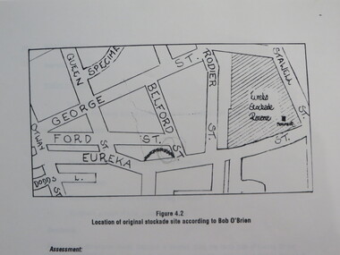
Report, Concept Study for the Further Development of the Eureka Stockade Reserve Conservation Plan, Vol 3, c1992
The objectives of the study were to * gather historical data and confirm the cultural significance of the site and reserve. * review existing site conditions including ownership together with current and proposed land uses. * Eureka Stockade location Copy of a 38 page report called "Concept Study for the Further Development of the Eureka Stockade Reserve Conservation Plan Vol 3", published by Ballarat University College. Authors are not stated. eureka, eureka stockade, ballarat university college, bert strange, bob o'brien, weston bate, alec barnett, jack chisholm, lloyd jenkins, eureka stockade location, cultural significance, eureka stockade site -
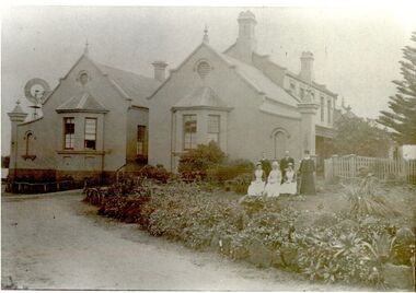
 Kinglake Historical Society
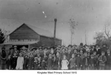
Kinglake West Primary School
Photograph of original Kinglake West Primary (State) School building with children and families. School built in 1896 by the pioneering families as Education Department would not build a school. Built on land selected by the Snell family.Only known photograph of the original school buildingPhotograph of original Kinglake West Primary School building education, school, pioneers, kinglake west -
 Peterborough History Group
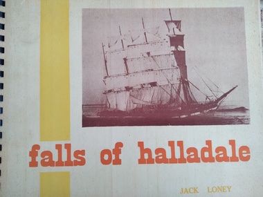
Book, Jack Loney, Falls of Halladale
Falls of Halladale wrecked to the West of Peterborough and the rocky point of land is now named Halladale Point. the book includes information about the history of the ship and photos of her in action, as well as information and photos of the wreck.Jack Loney researched and wrote a number of books about many shipwrecks along the Victorian coast. This limited edition book summarises the history of the barque Falls of Halladale, which wrecked just to the west of Peterborough and includes interesting photos of the ship at sail and as a wreck on the reef.A3 landscape style spiral bound book with stiff, cardboard pages. Limited editionInside it is noted that this is copy number 452 of 1000 copies, and is signed by the author. Also inscribed in pencil is " Donated by Barry Jenkins"shipwrecks, peterborough, falls of halladale, jack loney -
 Whitehorse Historical Society Inc.
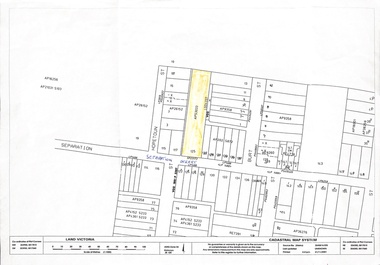
Map, 125 Separation Street, Northcote. Cadastral Map, 21/11/2001
A3 Cadastral Map of 125 Separation Street, Northcote August Schwerkolt purchased this property on 01/08/1853 where he lived and farmed the land, eventually purchasing the Mitcham property as well in 1861An A3 cadastral mapschwerkolt august -
 Bialik College
Scrapbooks, Student work
Scrapbooks of student work, including 'The Beginning', 'Land Reclamation', 'Planting Trees', 'Good Farming', 'Planning and Roads', c. 1980s and a booklet of poetry, 1984. Please contact [email protected] to request access to this record.student work, poetry, 1980s -
 Buninyong & District Historical Society
Photograph - B/W photograph, St. Alban's Cottage c 1873, former home of Dr. Sparling, July 1993
Built around 1873 by Dr. Sparling, on land formerly occupied by the first Buninyong Inn (aka Jamieson's Hotel). Some materials from the demolished hotel may have been used in building the house.Good example of 1870's professional residence, links to prominent citizen Dr Sparling.B/W Photograph, Polychrome brick cottage, L-fronted with bullnose verandah, on bluestone foundations with low bluestone fence. Signs "Buninyong Antiques" (under verandah) and "Antiques" on front of building.buninyong, sparling, jamieson, house, brick -
 Kew Historical Society Inc
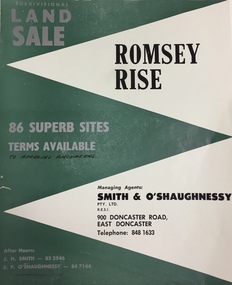
Plan - Subdivision Plan, Romsey Rise, Doncaster East
Real estate brochure for a land sale of 86 sites in East Doncaster. Roads identified in the plan include: George Street, Dennert Street, Worthing Avenue, Sandhurst Street, Belinda Crescent, and Romsey Rise.Historic subdivision plan of a Doncaster East EstateFour page colour real estate brochure including on page 2 a subdivision plan for the Romsey Rise estate in East Doncaster. This record also includes a separate price list for the lots.real estate plans, subdivision plans - doncaster east, romsey rise estate - doncaster east (vic) -
 Kew Historical Society Inc
Photograph - Yarra Flats near Burke Road Bridge, 1937
Land along the Yarra River in Kew is now either designated open space, parkland or public golf links. By the 1930s much of this area remained open farmland, bought at auction for dairy farming in the 1840s.Original, black and white positive print of what is said to be the Yarra Flats near Burke Road Bridge. On the horizon, building can be seen, whereas in the middle ground, farm fencing and a windmill are the main features as well as remnant Eucalypts. Inscribed verso: "Yarra Flats near Burke Rd Bridge 1937" studley park -- kew (vic.) -
 Port Fairy Historical Society Museum and Archives
Photograph
The Stag built 1848-1853.Land was purchased from Atkinson by John Sanders to serve as Licensed premises. The Bank of Australasia was built around 1855-57, designed by Nathaniel Billing and built by McKenzie and McCowan .Black and white Photograph of Two story bluestone Bank of Australasia in centre, two story Rendered Stag Hotel on left and 2 story Bank hotel on righthotel, bank, stag, australasia, nathanial billing, mckenzie, mccowan, john sanders -
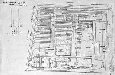 Melbourne Tram Museum
Document - Plan of Preston Workshops, The Met, c1990
Plan shows the layout of the Preston Workshops facility during The Met era, c1990. Shows tracks, buildings and overall land dimensions. Prepared prior to the duplication of the track over the railway line in Miller St. Yields information about Preston Workshops during The Met era.Photocopy - foolscap sheet of a Plan of Preston Workshops - The Met c1990tramways, preston workshops, drawings, plans -
 Port Fairy Historical Society Museum and Archives
Photograph, Pt Fairy Hospital looking east 1890, 1890
The land for this building was granted to the Benevolent Society by James Atkinson in 1850. Tenders were called for a new "Benevolent Asylum" in 1855, the foundation stone having been laid and by 1856 the first part of the Hospital was completedBlack and white photograph New addition to the hospital with i’ts bay windows. 5 women and two men posed to the sidehospital, health service, nurses, bay window -
 City of Moorabbin Historical Society (Operating the Box Cottage Museum)
Photograph - Map of Dendy's Special Survey, 1852 Map of Henry Dendy's Special Survey of 1841, 19th Century
A Map drawn in 1852 that shows the 5,120 acres that formed Dendy's Special Survey of 1841. In 1840 Henry Dendy, a farmer in Surrey, England acquired a "Special Survey" from the Commissioners for Land and Emigration which gave Dendy the right to choose land in Port Phillip for the "bargain basement" price of only £1 per acre for 5120 acres, (an area of 8 square miles). The Special Survey also included the right to "the shipment of a worker for every £20 spent on land, whose free passage was paid by the Crown, equalling a total of 100 workers ". Accordingly Dendy sold his English holdings and paid the required £5120 and arrived in Melbourne in February 1841. However by this time land in the new colony was selling for £5 - £40 per acre. Because Henry Dendy possessed the order from the Colonial Office in London he was able to successfully oppose Governor LaTrobe's attempts to alter the price of the land. Dendy appointed Jonathan Were, (an entrepreneur, who had arrived in 1839), as his Manager and who later became a partner. Together, Dendy and Were decided on an area 5 miles south from Melbourne, bounded by North Road, East Boundary Road, South Road and to the west by Port Phillip Bay. Were and Dendy pitched their tents in the area now known as ' Park St, Brighton' and sank a well near the corner of 'St Andrew's St and Wells St'. By 1845 J.B Were and Company had bought almost half of Dendy's land and Were built himself "Moorabbin House" in Were St Brighton made from stone, quarried from local cliffs. It was still standing in 1924. Legend records Moorabbin is named after the Aboriginal word for ' Mother's Milk ' The soil is very fertile and well supplied with water especially in the area called 'East Brighton' - now known as Bentleigh and East Bentleigh - By 1850 the area had developed with numerous market gardens, dairy farms, fruit gardens and vineyards supplying food for the growing population of Melbourne.This Map shows the birth of the Brighton and Moorabbin area. On 18th January1859 Brighton was proclaimed a Municipality and a Borough by October 1863. Meanwhile, following a Petition, the area of East and South Brighton, incorporating Mordialloc, Cheltenham, Mentone, Sandringham and Oakleigh separated from Brighton to form the Moorabbin District Roads Board becoming the first Local Government Authority. Col. William Mair was elected as the first Chairman of the Moorabbin Roads Board. Moorabbin Shire 1871 developed further and was declared a City in1934. The City of Moorabbin was the largest Municipality in Melbourne before the Amalgamation of Councils in 1994 when it was divided in the south to City of Kingston and in the north to City of Glen Eira A Photo-lithographed 1852 Map showing the 5,120 acres that formed Dendy's Special Survey of 1841. Henry Dendy & Jonathan Were chose an area 5 miles south from Melbourne, bounded by North Road, East Boundary Road, South Road and to the west by Port Phillip Bay. Moorabbin County of Bourke / Photo-Lithographed at the department of Lands and Survey. /Melbourne. / Price 1/- brighton, moorabbin, bentleigh, cheltenham, dendy henry, bent thomas, were jonathan, special survey -
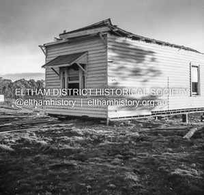
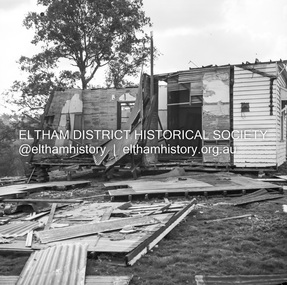
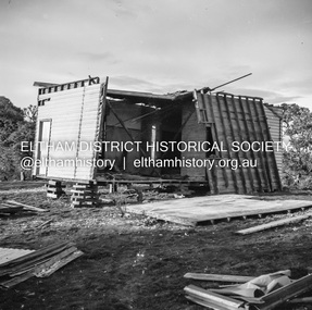 Eltham District Historical Society Inc
Negative - Photograph, J.A. McDonald, Inspection of storm damaged Abraham house at Kangaroo Ground, c. May 1962
Showing the effect of a wind storm that destroyed the house circa May 1962.. The Abraham family owned land near the Aqueduct and east of Nicholas Lane at Kangaroo Ground (based on photos, at or near 40 Nicholas Lane).Record of various Shire of Eltham infrastructure works undertaken during the period of 1952-1962 involving bridge and road reconstruction projects, sometimes with Eltham Shire Council Project Reference numbers quoted. It was during this period that a number of significant improvements were made to roads and new bridges constructed within the shire that remain in place as of present day (2022). In many situations, the photos provide a tangible visible record of infrastructure that existed throughout the early days of the Shire. The album was put together by or under the direction of the Shire Engineer, J.A. McDonald.1962-05, abraham house, kangaroo ground, nicholas lane, property damage, storm damage -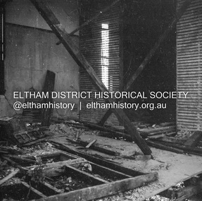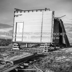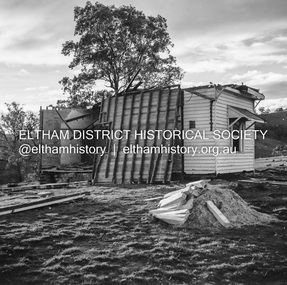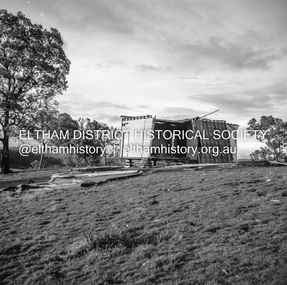
 Eltham District Historical Society Inc
Negative - Photograph, J.A. McDonald, Inspection of storm damaged Abraham house at Kangaroo Ground, c. May 1962
Showing the effect of a wind storm that destroyed the house circa May 1962.. The Abraham family owned land near the Aqueduct and east of Nicholas Lane at Kangaroo Ground (based on photos, at or near 40 Nicholas Lane).Record of various Shire of Eltham infrastructure works undertaken during the period of 1952-1962 involving bridge and road reconstruction projects, sometimes with Eltham Shire Council Project Reference numbers quoted. It was during this period that a number of significant improvements were made to roads and new bridges constructed within the shire that remain in place as of present day (2022). In many situations, the photos provide a tangible visible record of infrastructure that existed throughout the early days of the Shire. The album was put together by or under the direction of the Shire Engineer, J.A. McDonald.1962-05, abraham house, kangaroo ground, nicholas lane, property damage, storm damage, building surveyor, george e. newton -
 Eltham District Historical Society Inc
Negative - Photograph, J.A. McDonald, Inspection of storm damaged Abraham house at Kangaroo Ground, c. May 1962
Showing the effect of a wind storm that destroyed the house circa May 1962.. The Abraham family owned land near the Aqueduct and east of Nicholas Lane at Kangaroo Ground (based on photos, at or near 40 Nicholas Lane).Record of various Shire of Eltham infrastructure works undertaken during the period of 1952-1962 involving bridge and road reconstruction projects, sometimes with Eltham Shire Council Project Reference numbers quoted. It was during this period that a number of significant improvements were made to roads and new bridges constructed within the shire that remain in place as of present day (2022). In many situations, the photos provide a tangible visible record of infrastructure that existed throughout the early days of the Shire. The album was put together by or under the direction of the Shire Engineer, J.A. McDonald.1962-05, abraham house, kangaroo ground, nicholas lane, property damage, storm damage -
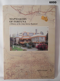 Bendigo Military Museum
Book - Mapmakers of Fortuna, a History of the Army Survey Regiment, Ex Fortuna Survey Association Inc, 2003
Covers the arrival of the Land Headquarters Cartographic Company at Fortuna Villa in 1942 until the disbandment of the Army Survey Regiment in 1996. Written by Valerie Lovejoy as part of her Masters degree at La Trobe University, BendigoUnit History of the Army Survey Regiment by Valerie Lovejoy, ISBN: 0-646-42120-4, 234 pages, 9 Chapters, 6 Appendices, Black and White photographs, Colored map extracts, Colored cover jacket, hard cover, nominal roll of Unit members.On first page, "Donated to Bendigo RSL Museum by Ex Fortuna Survey Association Inc 21 April 2022"royal australian survey corps, rasvy, army survey regiment, army svy regt, asr -
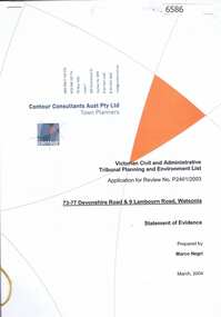 Greensborough Historical Society
Document, Statement of evidence: VCAT Application P2461/2003, prep. by Marco Negri, Contour Consultants Aust Pty Ltd, 2004_03
Lawyers for the City of Banyule commissioned a report on the town planning implications of a proposal to construct a multi-level building on land at the corner of Lambourn and Devonshire Roads Watsonia, relating to the Council's refusal of a permit and the subsequent hearing by VCAT22 p., black & white with col. plans.watsonia, lambourn road watsonia, devonshire road watsonia -
![Photograph - Digital image, Edward Theodore Flintoff [and grave], 1870c](/media/collectors/4f729f5697f83e03086015b8/items/54434cd12162f10ea4a15f2b/item-media/544352ec2162f10ea4a19c55/item-fit-380x285.jpg) Greensborough Historical Society
Greensborough Historical SocietyPhotograph - Digital image, Edward Theodore Flintoff [and grave], 1870c
Photograph of a portrait of Edward Theodore Flintoff and his grave. The Flintoff family came to Greensborough circa 1841. They owned, farmed and leased land north of the present Civic Drive. Edward died on 14/06/1899. A pioneer Greensborough family.Digital copy of colour photographs.flintoff family, edward theodore flintoff -
 Greensborough Historical Society
Document, Last Will and Testament of James Black, 1853_
Last will and testament of James Black of Pilgrim Inn, Plenty Road, with probate documents, 1854. Preceded the unrelated Black family who leased and owned land in the Watsonia area in the late 19th and early 20th centuries.5 p. photocopies of Will and Bondjames black [plenty road] -
 Greensborough Historical Society
Photograph - Digital image, Building of Greensborough Plaza, 1978_
Building of Greensborough Plaza was done in the late 1970's and opened in 1978. It occupied land previously used largely for residential and grazing purposes. This project saw the transformation of a sleepy outer suburb into the activity centre it now is. Digital copy of colour photograph.greensborough plaza, building projects -
 Orbost & District Historical Society
dress
This dress is from the estate of James Cameron who was one of the first Snowy River councillors for the Tambo Shire. He selected land at Lochiel in 1892. From 1902-1920 he was the Assembly member for East Gippsland.Long black silk dress with long sleeves. It is hand-made - machine stitched. There is black beading around the neck and collar. The belt is also beaded. There are small black buttons on the belt and sleeves. It has a black underskirt.costum -female cameron -
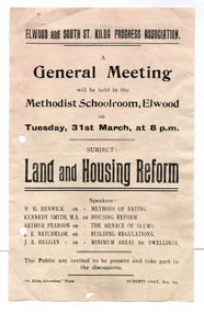 St Kilda Historical Society
Ephemera - Flyer, Land and Housing Reform, c1920-1940
For public meeting of Elwood and South St Kilda Progress Association on land and housing reform. The full date is not given. The Association met on Tuesday nights in the Methodist School Room, Elwood in the early - mid 20th century.White paper, discoloured by age,, printed one side in blackelwood and south st kilda progress association, housing reform -
Tatura Irrigation & Wartime Camps Museum
Photograph, Old Saleyards 1927
Original photograph of McNamara's saleyards during demolition. Looking west along Hogan Street, Tatura. New saleyards were established on land bordered by Ross Street, O'Toole Street, Maher Street and O'Reilly Roadl.Black and white photograph of old saleyards being demolished, Hogan Street, Tatura. Exterior. Approx. 1927.McNamaras old saleyards being demolished.old saleyards tatura -
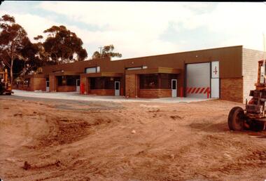 Hume City Civic Collection
Photograph, 1/12/1982
The railway land between Horne Street and the railway line was developed for commercial and industrial purposes during the late 1970s and early 1980s. The former Shire of Bulla developed much of this area and leased the space to private companies.A coloured photograph with rounded corners of 4 brick factory units. There is a large digger on the RHS. The area in front of the units has been paved but the remaining area is unsealed.factories, industrial estates, shire of bulla, george evans collection