Showing 25659 items
matching plenty-township-estate
-
 Fire Services Museum of Victoria
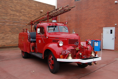
Vehicle - Fire Engine - Pumper "SEC Dodge", "SEC Dodge"
Maufactured for State Electricity Commission of Victoria (SEC) fire brigade at Yallourn township serving the nearby open cut brown coal mine, briquette manufacturing plant and electricity generating station. Donated to FSMV 19??, on closure of Yallourn Fire Brigade preparatory to closure of township to allow extension of open cut mine over township site.Unique only fire engine of design ever made.Pumper fire engine State Electricity Commission of Victoria (SEC) Fire Brigade, Yallourn, Vic Front mounted pump, ?, ? lpm [ ? gpm] Seat for 4 crew open cross mounted behind cab Ladder, ? m [ ? feet] Water tank ? l [ ? gall] Hose reel ? m [ ? feet] Current vehicle registration - CH6281 SEC logo on both doors Y F B on compartment door on both sides of bodyfire engine, fire engine pumper, dodge fire engine, dodge, yallourn fire brigade, sec fire brigade, yallourn, sec -
 Eltham District Historical Society Inc
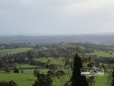
Photograph, View of Kangaroo Ground, 10 August 2016
View of Kangaroo Ground from the Moor rul Viewing Platform. As part of a program to acknowledge the Anzac Centenary Nillumbik Shire Council partnered with Yarra Plenty Regional Library to provide a bus tour with commentary of local sites of significance. These included Eltham township, the Shire of Eltham War Memorial at Kangaroo Ground, Christmas Hills war memorial, Hurstbridge memorial recreation park and finshed at Eltham Library to view the Writing the War exhibtion at Eltham Library Community Gallery. View of Melbourne from the Moor-rul viewing platform at War memorial park Kangaroo Ground, Garden Hill. Born Digitalwar memorials, shire of nillumbik, kangaroo ground, view, skyline, melbourne, moor-rul viewing platform, garden hill -
 Eltham District Historical Society Inc
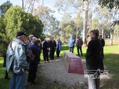
Photograph, Shire of Nillumbik World War One Memorials tour, 10 August 2016, 10 August 2016
As part of a program to acknowledge the Anzac Centenary Nillumbik Shire Council partnered with Yarra Plenty Regional Library to provide a bus tour with commentary of local sites of significance. These included Eltham township, the Shire of Eltham War Memorial at Kangaroo Ground, Christmas Hills war memorial, Hurstbridge memorial recreation park and finshed at Eltham Library to view the Writing the War exhibtion at Eltham Library Community Gallery. In May 2015 Nillumbik Shire Council received Anzac Centenary Local Grants Program funding for the restoration and enhancement of the Christmas Hills cenotaph as a project to commemorate the First World WarBorn Digitalworld war 1, war memorials, shire of nillumbik, christmas hills, tour, interpretative signage -
 Eltham District Historical Society Inc
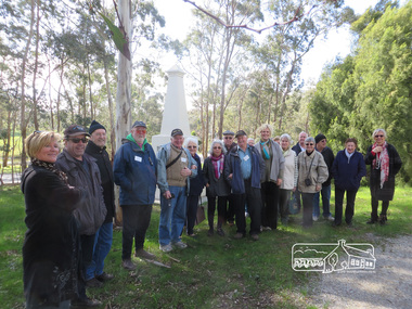
Photograph, Shire of Nillumbik World War One Memorials tour, 10 August 2016, 10 August 2016
As part of a program to acknowledge the Anzac Centenary Nillumbik Shire Council partnered with Yarra Plenty Regional Library to provide a bus tour with commentary of local sites of significance. These included Eltham township, the Shire of Eltham War Memorial at Kangaroo Ground, Christmas Hills war memorial, Hurstbridge memorial recreation park and finshed at Eltham Library to view the Writing the War exhibtion at Eltham Library Community Gallery. In May 2015 Nillumbik Shire Council received Anzac Centenary Local Grants Program funding for the restoration and enhancement of the Christmas Hills cenotaph as a project to commemorate the First World War Born Digitalworld war 1, war memorials, shire of nillumbik, christmas hills, tour, cenotaph, group -
 Glenelg Shire Council Cultural Collection
Pamphlet - Menu Card for Victorian National Resources Development Train, 23/04/1939
Menu card for Victorian National Resources Development Train, April 18 - May 1 1939. Front cover full colour, showing fields and flocks in background, goddess of plenty with pile of produce, in foreground. Inside card, menu for tea April 23 1939, plus table of Victoria's prowess at industry and productionFront: 'B. VIVIAN' - handwritten, pencil -
 Port Fairy Historical Society Museum and Archives
Newspaper - Newspaper article
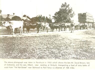
This photo was taken in Penshurst in 1903 which shows the late David Brown, late of Colerain Balmoral and his son, Albert, now residing at Gritjurk, transporting a load of sixty bales of wool from “Yat Nat Estate” near Balmoral to Port Fairy —a distance of 108 miles.Black and white photograph from a newspaper article with a large wool laden wagon with 14 bullocks yoked up The above photo was taken in Penshurst in 1903 which shows the late David Brown, late of Colerain Balmoral and his son, Albert, now residing at Gritjurk, transporting a load of sixty bales of wool from “Yat Nat Estate” near Balmoral to Port Fairy —a distance of 108 miles.transport, rail, road, bullocks, wagon, carrier, penshurst, balmoral, albert brown, david brown, wool bales, yat nat estate, gritjurk -
 Eltham District Historical Society Inc
Album - Photograph, J.A. McDonald, Eltham-Yarra Glen Road, 18 Oct. 1956
Eltham-Yarra Glen Road Proposed crossing of Plenty River at Lower Plenty. Floods 18th October 1956.Record of various Shire of Eltham infrastructure works undertaken during the period of 1952-1962 involving bridge and road reconstruction projects, sometimes with Eltham Shire Council Project Reference numbers quoted. It was during this period that a number of significant improvements were made to roads and new bridges constructed within the shire that remain in place as of present day (2022). In many situations, the photos provide a tangible visible record of infrastructure that existed throughout the early days of the Shire. The album was put together by or under the direction of the Shire Engineer, J.A. McDonald.infrastructure, road construction, shire of eltham, bridge construction, eltham-yarra glen road, 1956-10-18, floods, floodwater, lower plenty, plenty river -
 Bendigo Historical Society Inc.
Document - L. PROUT COLLECTION: ESTATE ALICE LATTA
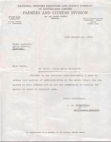
Letter dated 13th September, 1962 addressed to miss L. Prout, Quick Street, Ironbark from National Trustees Executors and Agency. Estate Alice latta deceased advising that letters of administration in the above Estate has now issued to this company.document -
 Ringwood and District Historical Society
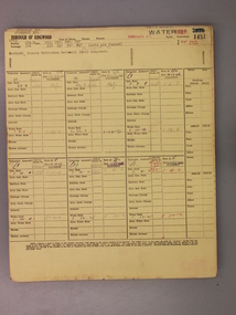
Administrative record - Rate Books, Borough of Ringwood Valuation & Rate Cards for 1944-49 (Assessments 1451 -1454), March 2012
Originally stored at Ringwood Council offices, then taken to PROV.Only source of ratepayers in the Borough of RingwoodDigital imagesPanaroma Cres, Ringwood. For Jessie Woodard (Pinemont Estate) and Robert Varley (Beals Subdivision). -
 Bendigo Historical Society Inc.
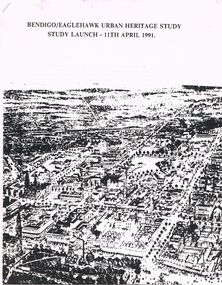
Document - BENDIGO/EAGLEHAWK URBAN HERITAGE STUD: STUDY LAUNCH 11TH APRIL 1991, 11/04/1991
Bendigo/Eaglehawk Urban Heritage Study - Study Launch 11th April 1991. Three page document with attachments and appendices. Details of Purpose of the Study; Management of the Study (including names of consultants); budget area, strategy, timing etc. Three pages (illustrated of places to visit (46 numbered localities); map of Eaglehawk with 24 numbered locations; Appendices.City of Bendigo, Borough of Eaglehawk, The Historic Buildings Council, Victoria National Estate Committeebendigo, council, heritage study, heritage study, bendigo, eaglehawk. historic building council, victoria national building committee. -
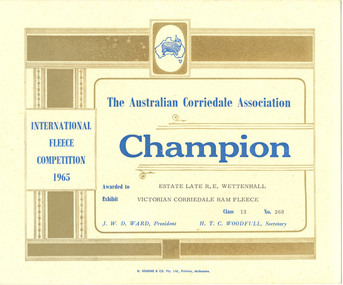 National Wool Museum
Certificate, The Australian Corriedale Association: Champion - International Fleece Competition 1965
The Wettenhall family were well known sheep breeders. The family owned the "Stanbury" corriedale stud at Ceres.ESTATE LATE R E WETTENHALL/ VICTORIAN CORRIEDALE RAM FLEECE/ 13/ 268sheep breeding corriedale studs agricultural shows, stanbury corriedale stud australian corriedale association, sheep breeding, corriedale studs, agricultural shows -
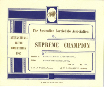 National Wool Museum
Certificate, The Australian Corriedale Association: Supreme Champion - International Fleece Competition 1965
The Wettenhall family were well known sheep breeders. The family owned the "Stanbury" corriedale stud at Ceres.ESTATE LATE R E WETTENHALL/ VICTORIAN CORRIEDALE RAM FLEECE/ 13/ 268sheep breeding corriedale studs agricultural shows, stanbury corriedale stud australian corriedale association, sheep breeding, corriedale studs, agricultural shows -
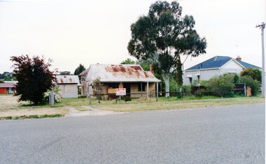 Stawell Historical Society Inc
Photograph, THis Old House - For Sale ( Clifton Ave)
Colour Photograph showing a miner cottage for sale, with an old wood and wire fence and rusty gateA Sign on the Fence Partially reads "For Sale Monaghan's Real Estate ( The rest of the sign is unclear) -
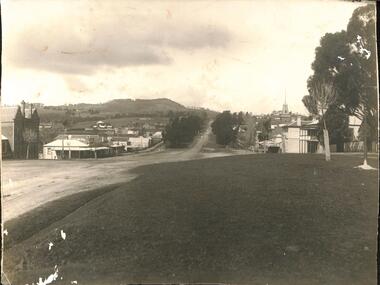 Buninyong & District Historical Society
Photograph - Original Photograph, Buninyong, from crossroads, 1924, 1924
record of township 1920'sB/W photo, Buninyong, from crossroads, 1924buninyong, crown hotel, learmonth st., warrenheip st, caffrey's shoeing forge, buninyong hotel -
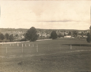 Buninyong & District Historical Society
Photograph - Original Photograph, View of Buninyong, 1920's, believed taken for Rose Post-card series, 1924
record of township 1920'sB/W photo, Buninyong, from crossroads, 1924buninyong -
Clunes Museum
book, HEDGES & BELL PTY. LTD. HIGH ST. MARYBOROUGH VIC, MARYBOROUGH 1854 - 1954 THE STORY OF A CENTURY, 1954
CARDBOARD COVERED BOOK OF MARYBOROUGH'S HISTORY. BY HAROLD V. NUNN 64 Pages, TITLED ' THE STORY OF A CENTURY'local history, book -
Kew Historical Society Inc
Plan - 30 Choice Home Sites in Kilby Road, Meldrum Street and Fairway Drive, 1965
Subdivision plans and real estate flyers/brochures reveal a number of aspects of urban development and history. The Kew Historical Society's collection of these plans, as well as advertisements extracted from magazines, cover key aspects of community development and architectural history of Kew and Kew Eat as well as surrounding suburbs. While most of the plans in the collection were gifted to the Society by the former City of Kew, a number of other plans and advertisements have been donated by individuals, of which this is an example.Original 4-page, bifold brochure, one of two in the collection, of home sites created following the creation of the Eastern Freeway which separated a section of land owned by the Kew Golf Club from the main course. The new estate featured 30 lots in Meldrum Street, Kilby Road and Fairway Drive. subdivisions -- kew east (vic.), subdivisions -- kew (vic.), kew golf club -
Kew Historical Society Inc
Plan - 30 Choice Home Sites in Kilby Road, Meldrum Street and Fairway Drive, 1965
Subdivision plans and real estate flyers/brochures reveal a number of aspects of urban development and history. The Kew Historical Society's collection of these plans, as well as advertisements extracted from magazines, cover key aspects of community development and architectural history of Kew and Kew Eat as well as surrounding suburbs. While most of the plans in the collection were gifted to the Society by the former City of Kew, a number of other plans and advertisements have been donated by individuals, of which this is an example.Original 4-page, bifold brochure, one of two in the collection, of home sites created following the creation of the Eastern Freeway which separated a section of land owned by the Kew Golf Club from the main course. The new estate featured 30 lots in Meldrum Street, Kilby Road and Fairway Drive.subdivisions -- kew east (vic.), subdivisions -- kew (vic.), kew golf club -
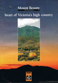 Kiewa Valley Historical Society
Poster Brochure, Mt Beauty Tawonga Heart Of Victoria's High Country, Circa 1995
The Item is a pictorial time piece of the valley and usage, farms,industry,town area, vegetation and winter snow levels Historical and the social-economical development at circa 1995 of land usage and residential buildings style.Major social events e.g. Festival of the Bogong Moth and the Mt Beauty Mardi Gras. It is also a good historical record of tourism campaigns of the Alpine Shire and Mt Beauty Chamber of Commerce. Also see "KVHS 0125"Brochure folds out from a 20.5cm x 29.5cm to 82cm x 29.5cm poster type documentinside panoramic photo of snow tipped alpine mountain range incorporating the Mount Beauty township, farming area of the Kiewa Valley and relevant tourist orientated informationtourism mt beauty tawonga photographs, victorian alps -
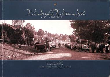 Ringwood and District Historical Society
Book, Valerie Polley, Wonderful Warrandyte - A Portrait, 2014
Soft-covered book by Valerie Polley, Warrandyte Historical Society, featuring photographs, sketches and text outlining early and contemporary development of Warrandyte township and community, first published in April 2014.Front cover - Peace Day celebrations in Warrandyte, July 1919. Acknowledgements: The book project Wonderful Warrandyte-A Portrait was made possible by a grant under the Australian Government's 2012-2013 Your Community Heritage Program (Your Community Heritage - Sharing Community Heritage Stories). Several members of the Warrandyte Historical Society were involved in this book project which evolved after several years of development ideas. Valerie Polley wrote the text and selected photographs. Special thanks go to the Steering Committee of Margaret Kelly, Andy Bevan-Jones, Richard Morton and Wayne Rankin for their knowledgeable input and beneficial editing advice, Murray Houghton for his specialised historical knowledge and advice on further references, and Diane Baird for editing. The book would not have been possible without all the dedicated work of the Society's members, past and present, who have contributed to the Society's substantial archive. All proceeds from the sale of this book go to the Warrandyde Historical Society. Photographs: Stephen Reynolds, Austin Polley, Valerie Polley, Wayne Rankin, Ron Harris, Merv Naughton. Flora and Fauna photography by Nth Warrandyte, Osborne Peninsula, Landcare, Inc. Maps: Jock Macneish -
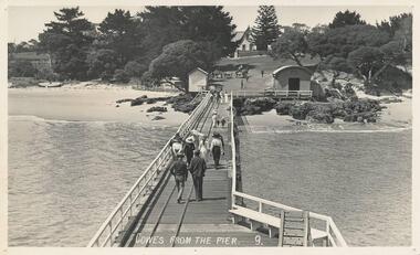 Phillip Island and District Historical Society Inc.
Photograph - Post Card, Early 20th Century
One of a group of photographs from the Bryant West Collection donated by Mary Karney.Black & White postcard. View from the pier of the Jetty Shed and Isle of Wight Hotel in the background. People walking down the pier towards the township. Two horse and carts beyond the shed.Cowes from the Pier. 9.cowes pier phillip island, cowes jetty shed, isle of wight hotel - cowes phillip island, bryant west collection, mary karney -
4th/19th Prince of Wales's Light Horse Regiment Unit History Room
Newspaper cutting, Feb 1900
Relates to Boer WarPart of a page from the Leader Newspaper printed in Feb 1900 about casualties suffered at Rensberg. Th page is badly damaged but shows shows photographs of some of the casualties and their home townshipsboer war casualties -
Bendigo Historical Society Inc.
Map - TOWNSHIP OF SANDHURST MAP
Map township of Sandhurst Portion B Bendigo Creek. Victoria zincographed at the Crown land's office, nos 54/21-57/12 Melbourne, April 21st 1857 (by G. Collis). -
 Bendigo Historical Society Inc.
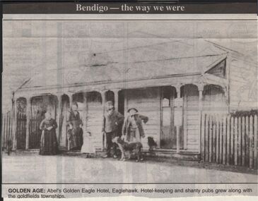
Newspaper - JENNY FOLEY COLLECTION: GOLDEN AGE
Bendigo Advertiser "The way we were" from 1999. n Golden age: Abel's Golden Eagle Hotel, Eaglehawk. Hotel keeping and shanty pubs greww along with the goldfields townships.newspaper, bendigo advertiser, the way we were -
 Bendigo Historical Society Inc.
Map - JACK FLYNN COLLECTION: HUNTLY, 12.03.1932
Map: Township of Huntly, Parish of Huntly , County of Bendigo. Parish plan. Western and South Riding Division on Main St. (Main Northern Highway) - written in ink below name of map.BY Authority H.J. Green. Photo-Lithographed at the Dept., of Lands and Survey, Melbourne. 12.3.32map, bendigo, township, huntly -
Lakes Entrance Regional Historical Society (operating as Lakes Entrance History Centre & Museum)
Book, Gippsland Heritage Journal - issue 25, 2001
Issue 25 of a series contains articles on Point Hicks lighthouse Buchan Caves Reserves, Mental Health in early Gippsland, Mallacoota, Gould township, 1840 diary of Matthew Macalister Photographs.township, lighthouses, photography -
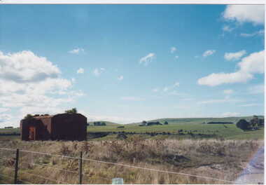 Clunes Museum
Photograph, KODAK, 1999
VIEW OF POWDER MAGAZINE USED IN MINING DAYS TO STORE EXPLOSIVES. BUILDING MATERIALS SOLID BRICKCOLOURED REPRINT PHOTOGRAPH OF POWDER MAGAZINE EXTERIOR. SITUATED IN A PADDOCK ON SMEATON ROAD APPROX. 2 KM. FROM TOWNSHIP ON LEFT HAND SIDE. IRON POST AND WIRE FENCE IN FOREGROUND.local history, photography, photographs, mining -
Clunes Museum
Plan - PLANS CLUNES CARAVAN PARK, NO. 1 - SHIRE OF TALBOT & CLUNES. IAN MANSLEY, SHIRE ENGINEER NO. 2 - LEO MCMAHON & ASSOCIATES PTY. LTD. LICENSED SURVEYORS & ENGINEERS, 31 LYONS ST. NTH. BALLARAT, 1976
NO. 1 PLAN - CLUNES CARAVAN PARK ENGINEER - IAN MANLEY NO. 2 PLAN - SECTION 15 TOWNSHIP OF CLUNES, COUNTY OF TALBOT, BY LEO MCMAHON AND ASSOCIATES, LICENSED SURVEYORS AND CIVIL ENGINEERSplans, caravan park, ian manley, plan section 15 -
 Whitehorse Historical Society Inc.
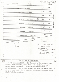
Document, Plan of Subdivision, 1861
Copy of plan of subdivision by Patrick RileyCopy of plan of subdivision by Patrick Riley of Section 77, Parish of Nunawading 'Springfield Township' 1861. Bounded by Whitehorse Road, Walker's Road, (now known as Springvale Road) and Springfield RoadCopy of plan of subdivision by Patrick Rileyland sales, riley, patrick, whitehorse road, nunawading, walkers road, springfield road, black street, robertson street, sandy street, burnt street, luckie street, bridge street, creek street, koonung street, thompson street -
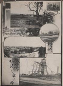 Rutherglen Historical Society
Photograph - Image, 1914 (Exact)
Black & white photograph, unframed but pasted to cardboard album page. A greetings postcard showing small scenes of the township, Mt Ophir vineyards, Garabaldi Mine, Swans and Great Southern Mine"The Season's Greetings From Rutherglen"mt ophir, garibaldi mine, great southern, winemaking, mining, gold mining, mount ophir