Showing 61 items matching " counties of talbot"
-
 Bendigo Historical Society Inc.
Map - RAVENSWOOD, COUNTIES OF BENDIGO & TALBOT, 12-12-22
... RAVENSWOOD, COUNTIES OF BENDIGO & TALBOT....Map, Ravenswood, Counties of Bendigo & Talbot, Shelbourne, Walmer, Harcourt, Sutton Grange, Mandurang, Lockwood.By Authority A.J.Mullett, Govt. ...(number 87 in map cupboard 1) Map RAVENSWOOD, COUNTIES OF BENDIGO & TALBOT. ...Map, Ravenswood, Counties of Bendigo & Talbot, Shelbourne, Walmer, Harcourt, Sutton Grange, Mandurang, Lockwood.By Authority A.J.Mullett, Govt. Printer, Melbourne. Photo-Lithographed at the Dept. of Lands and Survey, Melbourne by W.J.Butson 12-12-22, Price1/-. (number 87 in map cupboard 1)A.J.Mullett. Govt. Printer, Melbourne.map, bendigo, ravenswood -
 Ballan Shire Historical Society
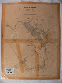
Map - Map. Korweinguboora, Department of Lands and Survey, Korweinguboora. Counties of Talbot and Grant
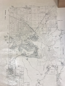
... Korweinguboora. Counties of Talbot and Grant....Korweinguboora. Counties of Talbot and Grant. Map Map. Korweinguboora. ...A map of the Korweinguboora area showing roads, forests, railway lines and properties with the owners names.The inclusion of the names of landowners is of significance and value to historians.A map of the Korweinguboora area showing land subdivisions and names of owners and other physical features. There is a scale in chains. No date is certain but it could be 1902. The map has been repaired with sellotape.There are various pencil annotations but the are difficult to read.talbot, moorarbool west, wombat, bullarto, korweinguboora, moorarbool east, dean, wombat state forest, barkstead -
 Bendigo Historical Society Inc.
Map - JACK FLYNN COLLECTION: EDDINGTON, 1.12.1925
... ... Counties of Talbot...Map: Parish of Eddington, Counties of Gladstone and Talbot. Parish plan....Butson 1.12.25 Map: Parish of Eddington, Counties of Gladstone and Talbot. Parish plan. Map JACK FLYNN COLLECTION: EDDINGTON ...Map: Parish of Eddington, Counties of Gladstone and Talbot. Parish plan.Dept of Lands and Survey Melbourne by W.J. Butson 1.12.25map, talbot, parish plan, eddington, counties of talbot, gladstone -
 Federation University Historical Collection
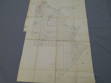
Plan - map, Ascot: Counties of Ripon and Talbot, 18/12/1920
... Ascot: Counties of Ripon and Talbot...Ascot: Counties of Ripon and Talbot Plan map W.J.Butson ...Cadastral map showing parish boundaries and land ownership. "L5270"Maps parishes located in Ascot area. Photo-Lithographed at the Dept. of Lands and Survey.Highlighted parish labelled, Mrs E.C.Sutherland.parish, map, ascot, counties, e. c. sutherland, a. cameron, sweeney, w. j. clarke, mount hollowback, tourello, burrumbeet, glendaruel, dowling forest, a. j. mullett, w. j. butson, 1920, william coghill, chatham, chatham family collection, mrs e.c.sutherland. -
 Bendigo Historical Society Inc.
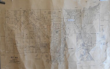
Map - JACK FLYNN COLLECTION: BET BET, 18/08/1931
... ... Counties of Gladstone and Talbot....Map: Parish of Bet Bet, Counties of Gladstone and Talbot . Parish plan....History House 11 Mackenzie Street Bendigo goldfields MAP Gladstone parish plan Bet Bet Counties of Gladstone and Talbot. By Authority H.J. Green Govt, Printer. ...Map: Parish of Bet Bet, Counties of Gladstone and Talbot . Parish plan.By Authority H.J. Green Govt, Printer. Photo Lithographed at the Department of Lands and Survey, Melbourne. 18.8.31map, gladstone, parish plan, bet bet, counties of gladstone and talbot. -
 Bendigo Historical Society Inc.
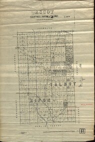
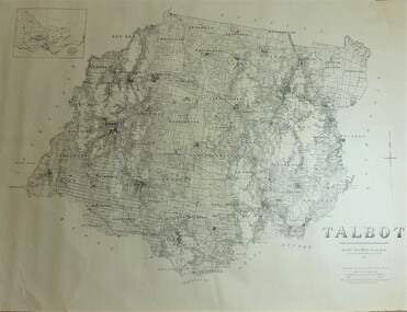
Map - JACK FLYNN COLLECTION: TALBOT, 1937
... ...county...Talbot...Map: County of Talbot, map sheet showing the whole of the County of Talbot and all of the Parishes within. ...Department of Lands and Survey Melbourne. 1959 Map: County of Talbot, map sheet showing the whole of the County of Talbot and all of the Parishes within. ...Map: County of Talbot, map sheet showing the whole of the County of Talbot and all of the Parishes within. Scale 2 Miles to 1 inch.By Authority: A.C. Brooks, Government Printer, Melbourne. Department of Lands and Survey Melbourne. 1959map, talbot, county, talbot -
 Bendigo Historical Society Inc.
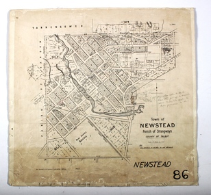
Map - NEWSTEAD, 15/10/1912
... ... County of Talbot...Map: Town of Newstead, Parish of Strangways, County of Talbot...History House 11 Mackenzie Street Bendigo goldfields MAP Talbot township Newstead County of Talbot Map: Town of Newstead, Parish of Strangways, County of Talbot Map NEWSTEAD ...Map: Town of Newstead, Parish of Strangways, County of Talbotmap, talbot, township, newstead, county of talbot -
 Bendigo Historical Society Inc.
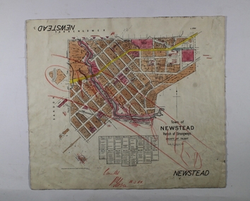
Map - NEWSTEAD, 1/11/1939
... ... County of Talbot...Map: Town of Newstead, Parish of Strangways, County of Talbot...History House 11 Mackenzie Street Bendigo goldfields MAP Talbot township Newstead Parish of Strangways County of Talbot Map: Town of Newstead, Parish of Strangways, County of Talbot Map NEWSTEAD ...Map: Town of Newstead, Parish of Strangways, County of Talbotmap, talbot, township, newstead, parish of strangways, county of talbot -
Clunes Museum
Plan - TITLE PLAN, DEPARTMENT OF LANDS AND SURVEY, TOWNSHIP OF GLENGOWER
... 1 PAGE PLAN OF THE TOWNSHIP OF GLENGOWER COUNTY OF TALBOT (11 COPIES) ...OF LANDS AND SURVERY MELBOURNE VICTORIA NOVEMBER 1954 PRICE 2/- 1 PAGE PLAN OF THE TOWNSHIP OF GLENGOWER COUNTY OF TALBOT (11 COPIES) TOWNSHIP OF GLENGOWER Plan TITLE PLAN DEPARTMENT OF LANDS AND SURVEY W M HOUSTON ...1 PAGE PLAN OF THE TOWNSHIP OF GLENGOWER COUNTY OF TALBOT (11 COPIES) DRAWN AND REPRODUCED AT THE DEPT. OF LANDS AND SURVERY MELBOURNE VICTORIA NOVEMBER 1954 PRICE 2/-parish of glengower, title plan of glengower -
Clunes Museum
Map - MAPS/ DOCUMENTS, CIRCA 1857
... COLLECTION OF DOCUMENTS (COPIES OF10 MAPS AND DIAGRAMS OF TOURAAL PURCHASED UNDER PREEMPTIVE RIGHT BY DONALD CAMEROM 17TH FEBRUARY, 1857. COUNTY OF TALBOT - GOLDFIELD'S SURVEY PLAN NO.1 CLUNES COUNTY OF TALBOT. ...Clunes Museum 36 Fraser Street enter building through Collins Place Clunes goldfields LOCAL HISTORY MINING COLLECTION OF DOCUMENTS (COPIES OF10 MAPS AND DIAGRAMS OF TOURAAL PURCHASED UNDER PREEMPTIVE RIGHT BY DONALD CAMEROM 17TH FEBRUARY, 1857. COUNTY OF TALBOT - GOLDFIELD'S SURVEY PLAN NO.1 CLUNES COUNTY OF TALBOT. ...COLLECTION OF DOCUMENTS (COPIES OF10 MAPS AND DIAGRAMS OF TOURAAL PURCHASED UNDER PREEMPTIVE RIGHT BY DONALD CAMEROM 17TH FEBRUARY, 1857. COUNTY OF TALBOT - GOLDFIELD'S SURVEY PLAN NO.1 CLUNES COUNTY OF TALBOT. GLENDONALD - CRESWICK/CLUNES.local history, mining -
Bendigo Historical Society Inc.
Map - HAWKESTONE, 17/11/1915
... ... County of Talbot...Map: Hawkestone, County of Talbot. Parish plan ( number 178 in Map Cupboard 1)...History House 11 Mackenzie Street Bendigo goldfields MAP Talbot parish plan Hawkestone County of Talbot Map: Hawkestone, County of Talbot. ...Map: Hawkestone, County of Talbot. Parish plan ( number 178 in Map Cupboard 1)map, talbot, parish plan, hawkestone, county of talbot -
Bendigo Historical Society Inc.
Map - HARCOURT, September 1951
... ... County of Talbot...Map: Harcourt, County of Talbot. Parish plan ( number 177 in Map Cupboard 1)...History House 11 Mackenzie Street Bendigo goldfields MAP Talbot parish plan Harcourt County of Talbot Map: Harcourt, County of Talbot. ...Map: Harcourt, County of Talbot. Parish plan ( number 177 in Map Cupboard 1)map, talbot, parish plan, harcourt, county of talbot -
Bendigo Historical Society Inc.
Map - HARCOURT, 2/04/1917
... Map: Town of Harcourt, County of Talbot. Parish plan (number 264 in map cupboard 1)...History House 11 Mackenzie Street Bendigo goldfields MAP Talbot township Harcourt Map: Town of Harcourt, County of Talbot. Parish plan (number 264 in map cupboard 1) Map HARCOURT ...Map: Town of Harcourt, County of Talbot. Parish plan (number 264 in map cupboard 1)map, talbot, township, harcourt -
 Federation University Historical Collection
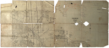
Plan, Creswick, County of Talbot
... Creswick, County of Talbot...Plan showing allotments in Creswick, County of Talbot. The plan is in a number of pieces with some sections missing....Creswick, County of Talbot Plan ...This plan is associated with former Ballarat School of Mines Student Richard Squire (1875-1876). Gift of the Squire Family, 2014 Plan showing allotments in Creswick, County of Talbot. The plan is in a number of pieces with some sections missing.creswick, creswick creek, spring hill, sarah paterson, lehman, mullins, spittle, squire, richard squire -
Bendigo Historical Society Inc.
Map - HARCOURT, No date visible
... Map: Township of Harcourt, Parish pf Harcourt, County of Talbot, (number 265 in map cupboard 1)...History House 11 Mackenzie Street Bendigo goldfields MAP Talbot township Harcourt Map: Township of Harcourt, Parish pf Harcourt, County of Talbot, (number 265 in map cupboard 1) Map HARCOURT ...Map: Township of Harcourt, Parish pf Harcourt, County of Talbot, (number 265 in map cupboard 1)map, talbot, township, harcourt -
Clunes Museum
Map, A.C. BROOKS GOVERNMENT PRINTER MELBOURNE, EGLINTON COUNTY OF TALBOT, 1965
... EGLINTON COUNTY OF TALBOT...MAP OF EGLINTON, COUNTY OF TALBOT PRINTED ON CANVAS WITH PLASTIC TAB FOR HANGING. ...MAP SHOWS TOWN ALLOTMENTS EGLINTON COUNTY OF TALBOT Map MAP A.C. BROOKS GOVERNMENT PRINTER MELBOURNE. ...MAP OF EGLINTONMAP OF EGLINTON, COUNTY OF TALBOT PRINTED ON CANVAS WITH PLASTIC TAB FOR HANGING. MAP SHOWS TOWN ALLOTMENTSADMINISTRATIVE STAMP ON BOTTOM LEFT AND ON THE BACK OF THE MAP ANOTHER STAMP - NORTHERN DIVISION (299) FORESTS COMMISSION BENDIGOeglinton, historical map -
 Federation University Historical Collection
Plan, Bungaree and Dean Parish and Geological Plan, 1890, 07/1890
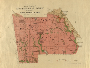
... Geological and Parish Map of parts of the Parishes of Bungaree and Dean in the Counties of Talbot, Grenville and Grant. The scale is 40 chains to one inch. ...Geological and Parish Map of parts of the Parishes of Bungaree and Dean in the Counties of Talbot, Grenville and Grant. The scale is 40 chains to one inch. ...Ferdinand M. Krause was a Professor at the Ballarat School of Mines.Geological and Parish Map of parts of the Parishes of Bungaree and Dean in the Counties of Talbot, Grenville and Grant. The scale is 40 chains to one inch. bungaree, deen, krause, f.m. krause, musk creek, clarkes hill, badger hill, beale's reservoir, acquainted. -
Clunes Museum
Plan
... 1 PAGE - AN EARLY, UNDATED PLAN OF THE TOWNSHIP OF CLUNES, COUNTY OF TALBOT, SHOWING REDUCED LEVELS AND CHAIN SURVEY OF ALL SECTIONS...THIS HAS BEEN ADDED AT A MUCH LATER DATE. local history plans 1 PAGE - AN EARLY, UNDATED PLAN OF THE TOWNSHIP OF CLUNES, COUNTY OF TALBOT, SHOWING REDUCED LEVELS AND CHAIN SURVEY OF ALL SECTIONS Plan PLAN ...PLAN HAS AN ATTACHED HAND PRINTED CARD WITH INFORMATION REGARDING SITES. THIS HAS BEEN ADDED AT A MUCH LATER DATE.1 PAGE - AN EARLY, UNDATED PLAN OF THE TOWNSHIP OF CLUNES, COUNTY OF TALBOT, SHOWING REDUCED LEVELS AND CHAIN SURVEY OF ALL SECTIONSlocal history, plans -
Clunes Museum
Map - PLAN / MAP
... ...COUNTY OF TALBOT....1 MAP, TOWN OF CLUNES, PARISH OF CLUNES, COUNTY OF TALBOT, STAMPED BOROUGH OF CLUNES .2 PLAN OF SUBDIVISION OF PART OF CLUNES COMMON, BOROUGH OF CLUNES, PARISH OF CLUNES,COUNTY OF TALBOT. ...OF LANDS AND SURVEY, MELBOURNE PRICE 1/- 10.11.08 .1 MAP, TOWN OF CLUNES, PARISH OF CLUNES, COUNTY OF TALBOT, STAMPED BOROUGH OF CLUNES .2 PLAN OF SUBDIVISION OF PART OF CLUNES COMMON, BOROUGH OF CLUNES, PARISH OF CLUNES,COUNTY OF TALBOT. ....1 MAP, TOWN OF CLUNES, PARISH OF CLUNES, COUNTY OF TALBOT, STAMPED BOROUGH OF CLUNES .2 PLAN OF SUBDIVISION OF PART OF CLUNES COMMON, BOROUGH OF CLUNES, PARISH OF CLUNES,COUNTY OF TALBOT. P. CAMPBELL. ASSISTANT SURVEYOR, MARCH 1904 ON RIGHT HAND BOTTOM CORNER C71/1 CLUNES COMMON. MARKED: CHARTED R.L.A.7/2/57.1 PHOTO LITHOGRAPHED. DEPARTMENT OF LANDS AND SURVEY, MELBOURNE .2 PHOTO LITHOGRAPHED AT THE DEP. OF LANDS AND SURVEY, MELBOURNE PRICE 1/- 10.11.08map town of clunes, borough of clunes, parish of clunes, county of talbot -
 Federation University Historical Collection
Map - Documents, Documents relating to Land - Selection of Maps of subdivisions; Titles; Cemetery sections
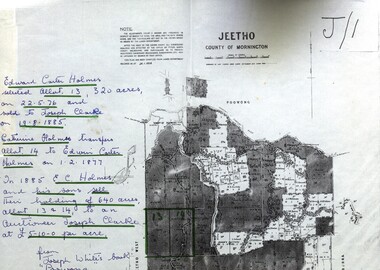
... ...counties of ripon and talbot...Maps indicate the land owned in various areas of Victoria - Mornington Peninsula, Ascot / Creswick area jeetho county of mornington edward carter holmes joseph clarke catherine holmes talbot william coghill pre-emptive right tourello pre-emptive right glendonald pre-emptive right clunes smeaton ascot counties of ripon and talbot certificate of title ballaarat general cemetery new cemetery Poowong Helen Coghill Land maps showing block divisions and owners. ...Maps indicate the land owned in various areas of Victoria - Mornington Peninsula, Ascot / Creswick areaLand maps showing block divisions and owners. Edward Carter Holmes J.P. selected land and called it Launchley - later called Wambalano.jeetho, county of mornington, edward carter holmes, joseph clarke, catherine holmes, talbot, william coghill, pre-emptive right, tourello pre-emptive right, glendonald pre-emptive right, clunes, smeaton, ascot, counties of ripon and talbot, certificate of title, ballaarat general cemetery, new cemetery, poowong, helen coghill -
 Bendigo Historical Society Inc.
Map - FARADAY, 10/01/1879
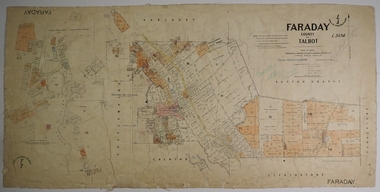
... Map: Parish of Faraday, County of Talbot. Parish plan. Draughtsman J T Thomson December 1877. ...Thomson Map: Parish of Faraday, County of Talbot. Parish plan. Draughtsman J T Thomson December 1877. ...Map: Parish of Faraday, County of Talbot. Parish plan. Draughtsman J T Thomson December 1877. Examined by J H Morgan 8/11/78map, talbot, parish plan, faraday, j. h. morgan, j. t. thomson -
Clunes Museum
Plan - PLANS CLUNES CARAVAN PARK, NO. 1 - SHIRE OF TALBOT & CLUNES. IAN MANSLEY, SHIRE ENGINEER NO. 2 - LEO MCMAHON & ASSOCIATES PTY. LTD. LICENSED SURVEYORS & ENGINEERS, 31 LYONS ST. NTH. BALLARAT, 1976
... NO. 1 PLAN - CLUNES CARAVAN PARK ENGINEER - IAN MANLEY NO. 2 PLAN - SECTION 15 TOWNSHIP OF CLUNES, COUNTY OF TALBOT, BY LEO MCMAHON AND ASSOCIATES, LICENSED SURVEYORS AND CIVIL ENGINEERS...Clunes Museum 36 Fraser Street enter building through Collins Place Clunes goldfields PLANS CARAVAN PARK IAN MANLEY PLAN SECTION 15 NO. 1 PLAN - CLUNES CARAVAN PARK ENGINEER - IAN MANLEY NO. 2 PLAN - SECTION 15 TOWNSHIP OF CLUNES, COUNTY OF TALBOT, BY LEO MCMAHON AND ASSOCIATES, LICENSED SURVEYORS AND CIVIL ENGINEERS Plan PLANS CLUNES CARAVAN PARK NO. 1 - SHIRE OF TALBOT & CLUNES. ...NO. 1 PLAN - CLUNES CARAVAN PARK ENGINEER - IAN MANLEY NO. 2 PLAN - SECTION 15 TOWNSHIP OF CLUNES, COUNTY OF TALBOT, BY LEO MCMAHON AND ASSOCIATES, LICENSED SURVEYORS AND CIVIL ENGINEERSplans, caravan park, ian manley, plan section 15 -
Clunes Museum
document - WILL, 1875
... COPY OF - THE LAST WILL AND TESTAMENT OF CHARLES GORDON [HOTEL KEEPER] OF THE BOROUGH OF CLUNES IN THE COUNTY OF TALBOT IN THE COLONY OF VICTORIA....Clunes Museum 36 Fraser Street enter building through Collins Place Clunes goldfields COPY OF - THE LAST WILL AND TESTAMENT OF CHARLES GORDON [HOTEL KEEPER] OF THE BOROUGH OF CLUNES IN THE COUNTY OF TALBOT IN THE COLONY OF VICTORIA. local history document will COPY OF WILL OF CHARLES GORDON OF CLUNES, VICTORIA document WILL ...COPY OF - THE LAST WILL AND TESTAMENT OF CHARLES GORDON [HOTEL KEEPER] OF THE BOROUGH OF CLUNES IN THE COUNTY OF TALBOT IN THE COLONY OF VICTORIA.COPY OF WILL OF CHARLES GORDON OF CLUNES, VICTORIAlocal history, document, will -
 Creswick Campus Historical Collection - University of Melbourne
Map, Creswick, 1943
... Dept of Lands and Survey map of Creswick and county of Talbot. 2 linen backed sheets rolled into white cardboard cylinder...Creswick Campus Historical Collection - University of Melbourne 4 Water Street University of Melbourne Creswick Campus Building 719/718 Creswick goldfields Dept of Lands and Survey map of Creswick and county of Talbot. 2 linen backed sheets rolled into white cardboard cylinder Maps Creswick Map ...Dept of Lands and Survey map of Creswick and county of Talbot. 2 linen backed sheets rolled into white cardboard cylinderMaps -
Bendigo Historical Society Inc.
Map - RAVENSWOOD : COUNTY OF BENDIGO, 28-7-14
... Ravenswood, County of Bendigo, County of Talbot, Lockwood, Sutton Grange, Harcourt, Walmer, Bradford, Shelbourne, Mandurang, Photo-Lithographed at the Department of Lands and Survey by T.F. ...Ravenswood, County of Bendigo, County of Talbot, Lockwood, Sutton Grange, Harcourt, Walmer, Bradford, Shelbourne, Mandurang, Photo-Lithographed at the Department of Lands and Survey by T.F. ...Map. Ravenswood, County of Bendigo, County of Talbot, Lockwood, Sutton Grange, Harcourt, Walmer, Bradford, Shelbourne, Mandurang, Photo-Lithographed at the Department of Lands and Survey by T.F. McGauran 28-7-14. (number 86 in map cupboard 1)T.F. McGauranmap, bendigo, ravenswood -
Bendigo Historical Society Inc.
Map - HAWKESTONE, COUNTY OF BENDIGO, December 1953
... Map, Hawkestone, County of Bendigo, County of Talbot, Sutton Grange, Redesdale, Lyell, Myrtle Creek, By authority W.M.Houston, Government Printer. ...Map, Hawkestone, County of Bendigo, County of Talbot, Sutton Grange, Redesdale, Lyell, Myrtle Creek, By authority W.M.Houston, Government Printer. ...Map, Hawkestone, County of Bendigo, County of Talbot, Sutton Grange, Redesdale, Lyell, Myrtle Creek, By authority W.M.Houston, Government Printer. Drawn and Reproduced at the Dept. of Lands and Survey, Melbourne, Victoria.December 1953. Price 5/-. (number 98 in map cupboard 1)W.M.Houston, Governmemt Printer.map, bendigo, hawkestone. -
Bendigo Historical Society Inc.
Map - SEDGWICK : COUNTY OF BENDIGO, 1963
... Sedgwick, County of Bendigo, Strathfieldsaye, Mandurang, Sutton Grange, Lyell, Eppalock County of Talbot Border. By authority A.C. Brooks, Government Printer, Melbourne. ...Sedgwick, County of Bendigo, Strathfieldsaye, Mandurang, Sutton Grange, Lyell, Eppalock County of Talbot Border. By authority A.C. Brooks, Government Printer, Melbourne. ...Map. Sedgwick, County of Bendigo, Strathfieldsaye, Mandurang, Sutton Grange, Lyell, Eppalock County of Talbot Border. By authority A.C. Brooks, Government Printer, Melbourne. Drawn and reproduced at the Department of Lands and Survey, Melbourne.1963, Price 2/-. (number 30 in map cupboard 1)A.C. Brooks, Government Printer, Melbourne.map, bendigo, sedgwick -
Bendigo Historical Society Inc.
Map - HAWKESTONE : COUNTY OF BENDIGO, December 1953
... Hawkestone, County of Bendigo, County of Talbot, Sutton Grange, Redesdale, Faraday, Elphinstone, Metcalfe, Coliban River. ...Hawkestone, County of Bendigo, County of Talbot, Sutton Grange, Redesdale, Faraday, Elphinstone, Metcalfe, Coliban River. ...Map. Hawkestone, County of Bendigo, County of Talbot, Sutton Grange, Redesdale, Faraday, Elphinstone, Metcalfe, Coliban River. By authority W.M. Houston, Government Printer. Drawn and reproduced at the Department of Lands and Survey, Melbourne. December 1953. Price 5/-. (number 97 in map cupboard 1)W.M. Houston, Government Printer.map, bendigo, hawkestone. -
Bendigo Historical Society Inc.
Map - RAVENSWOOD : COUNTY OF BENDIGO, 1971
... Ravenswood, County of Bendigo, Township of Ravenswood, County of Talbot, Bradford; Walmer; Harcourt; Lockwood; Mandurang; Sutton Grange.By Authority C.H.Rixon, Government Printer, Melbourne.Drawn and Reproduced at the Dept. of Crown Lands and Survey, Victoria. 1971. ...Ravenswood, County of Bendigo, Township of Ravenswood, County of Talbot, Bradford; Walmer; Harcourt; Lockwood; Mandurang; Sutton Grange.By Authority C.H.Rixon, Government Printer, Melbourne.Drawn and Reproduced at the Dept. of Crown Lands and Survey, Victoria. 1971. ...Map. Ravenswood, County of Bendigo, Township of Ravenswood, County of Talbot, Bradford; Walmer; Harcourt; Lockwood; Mandurang; Sutton Grange.By Authority C.H.Rixon, Government Printer, Melbourne.Drawn and Reproduced at the Dept. of Crown Lands and Survey, Victoria. 1971. Price $1.00 (number 5 in map cupboard 1)C.H.Rixon, Government Printermap, bendigo, ravenswood -
 Federation University Historical Collection
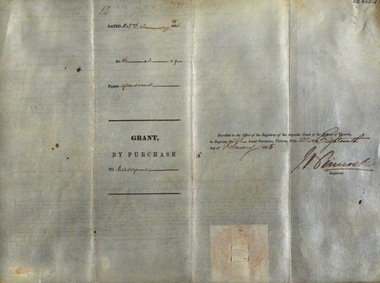
Document, Victoria: Land Purchase, Edward Ager Wynne, 1856, 23 January 1856
... county of talbot....1 Document outlining the purchase of Lot No. 39: 16 acres, 3 roods, 9 perches situated in the County of Talbot, Parish of Glendaruel by Edward Ager Wynne of Melbourne for the sum of Seventeen Pounds Thirteen Shillings .2 Document outlining the purchase of Lot No. 30: 50 acres, 2 roods, 38 perches situated in the County of Talbot, Parish of Glendaruel bu Edward Ager Wynne of Melbourne for the sum of Fifty Pounds Fourteen Shillings and Nine Pence Both documents were witnessed by Major-General Edward Macarthur the Senior, Officer in Command of Our Land Forces...Barker Library (top floor) Mount Helen goldfields .1 Document outlining the purchase of Lot No. 39: 16 acres, 3 roods, 9 perches situated in the County of Talbot, Parish of Glendaruel by Edward Ager Wynne of Melbourne for the sum of Seventeen Pounds Thirteen Shillings .2 Document outlining the purchase of Lot No. 30: 50 acres, 2 roods, 38 perches situated in the County of Talbot, Parish of Glendaruel bu Edward Ager Wynne of Melbourne for the sum of Fifty Pounds Fourteen Shillings and Nine Pence Both documents were witnessed by Major-General Edward Macarthur the Senior, Officer in Command of Our Land Forces county of talbot parish of glenaruel acres roods perches edward ager wynne major-general edward macarthue land purchase agreement Date: 23 January 1856 Signature: E Macarthur - Major General of Our Land Forces Official Seal Thick cream paper, hand written Victoria: Land Purchase, Edward Ager Wynne, 1856 Document ....1 Document outlining the purchase of Lot No. 39: 16 acres, 3 roods, 9 perches situated in the County of Talbot, Parish of Glendaruel by Edward Ager Wynne of Melbourne for the sum of Seventeen Pounds Thirteen Shillings .2 Document outlining the purchase of Lot No. 30: 50 acres, 2 roods, 38 perches situated in the County of Talbot, Parish of Glendaruel bu Edward Ager Wynne of Melbourne for the sum of Fifty Pounds Fourteen Shillings and Nine Pence Both documents were witnessed by Major-General Edward Macarthur the Senior, Officer in Command of Our Land Forces Thick cream paper, hand writtenDate: 23 January 1856 Signature: E Macarthur - Major General of Our Land Forces Official Seal county of talbot, parish of glenaruel, acres, roods, perches, edward ager wynne, major-general, edward macarthue, land purchase agreement