Showing 10 items matching " a geographical dictionary or gazetteer of the australian colonies"
-
 Orbost & District Historical Society
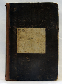
book, Effingham, Wilson, A Geographical Dictionary of the Australian Colonies, 1848
... A Geographical Dictionary of the Australian Colonies...A geographical dictionary or gazetteer of the Australian colonies : their physical and political geography : together with a brief notice of all the capitals, principal towns, and villages. ...A hard back 453 pp book with a dark brown patterned cover which has a white label with the title, "Dictionary of Geography" over a map of Australia. It is illustrated with numerous maps and drawings....Orbost & District Historical Society Ruskin Street Orbost gippsland A geographical dictionary or gazetteer of the Australian colonies : their physical and political geography : together with a brief notice of all the capitals, principal towns, and villages. ...A geographical dictionary or gazetteer of the Australian colonies : their physical and political geography : together with a brief notice of all the capitals, principal towns, and villages. William Wells travelled to Australia as a sponsored immigrant in 1838. Her became a freelance surveyor with an office in Bligh Street, Sydney. He wrote this book in order to better inform the British public on the colonies of Australia. The information contained in the book is both topographical and statistical and was a very useful refernece book at the time.This book is a rare detailed contemporary record of the Australian colonies in the mid 19th century.A hard back 453 pp book with a dark brown patterned cover which has a white label with the title, "Dictionary of Geography" over a map of Australia. It is illustrated with numerous maps and drawings.history-australia wells-william-henry geographical-dictionary-of-the-australian-colonies -
 Bendigo Historical Society Inc.
Document - MAJOR MITCHELL AND MOUNT ALEXANDER
... Australia Felix... W H Wells... A Geographical Dictionary or Gazetteer of the Australian Colonies...History House 11 Mackenzie Street Bendigo goldfields DOCUMENT Major Mitchell and Mount Alexander Tommy-Came-Last The Major Mitchell Tourist Trail Major General John Byng Phillip of Macedonia Alexander the Great Henty s Surveyor Davidson Alexander Mollison George Augustus Robinson William Morton Mr Charles Hotson Ebden John Randell Public Library of Melbourne Les Blake Governor Burke Phillip Parker King Crown Solicitor Henry Field Gurner Arthur Phillip Hume Australia Felix Expedition L Blake Place Names of Victoria G Brenmer Booklet for Secondary Schools M Cannon Historical Records of Victoria Vol 1 J H L Cumpston Thomas Mitchell Surveyor General and Explorer H F Gurner Chronicle of Port Phillip T L Mitchell Three Expeditions into the Interior of Eastern Australia A F Mollison An Overlanding Diary W L Morton Adventures of a Pioneer M S 5188 Itinerary from the Journal of the Exploring Expedition returning from Portland Bay M S 5189 Mitchell's 1837 Map J O Randell Pastoral Settlement in Northern Victoria Vol 1 Pastoral Settlement in Northern Victoria Vol 2 Records of the Victorian Archaeological Survey Number 5 Journals of George Augustus Robinson T C Sargent Some Peninsular Names in Australia Felix W H Wells A Geographical Dictionary or Gazetteer of the Australian Colonies Typed notes mentioning the naming of Mount Alexander, Coliban, Campaspe and who named them. ...Typed notes mentioning the naming of Mount Alexander, Coliban, Campaspe and who named them. Also the origins of the names.document, major mitchell and mount alexander, tommy-came-last, the major mitchell tourist trail, major general john byng, phillip of macedonia, alexander the great, henty s, surveyor davidson, alexander mollison, george augustus robinson, william morton, mr charles hotson ebden, john randell, public library of melbourne, les blake, governor burke, phillip parker king, crown solicitor henry field gurner, arthur phillip, hume, australia felix expedition, l blake, place names of victoria, g brenmer, booklet for secondary schools, m cannon, historical records of victoria vol 1, j h l cumpston, thomas mitchell surveyor general and explorer, h f gurner, chronicle of port phillip, t l mitchell, three expeditions into the interior of eastern australia, a f mollison, an overlanding diary, w l morton, adventures of a pioneer, m s 5188, itinerary from the journal of the exploring expedition returning from portland bay, m s 5189, mitchell's 1837 map, j o randell, pastoral settlement in northern victoria vol 1, pastoral settlement in northern victoria vol 2, records of the victorian archaeological survey number 5, journals of george augustus robinson, t c sargent, some peninsular names in australia felix, w h wells, a geographical dictionary or gazetteer of the australian colonies -
 Bendigo Historical Society Inc.
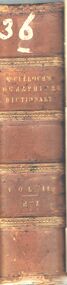
Book - A DICTIONARY GEOGRAPHICAL, STASTISTICAL, AND HISTORICAL. VOL. II
... A DICTIONARY GEOGRAPHICAL, STASTISTICAL, AND HISTORICAL. ...geography... stastistics... history... world... maps... Europe... world... place... dictionary...A hard covered book titled, '' A Dictionary, Geographical, Statistical, and Historical, of the various countries, places, and principal natural objects in The World. ...(maps) Book A DICTIONARY GEOGRAPHICAL, STASTISTICAL, AND HISTORICAL. ...A hard covered book titled, '' A Dictionary, Geographical, Statistical, and Historical, of the various countries, places, and principal natural objects in The World. Illustrated with maps. By J.R. McCulloch, Esq. Member of the Institute of France. A new edition revised, with a supplement. In two volumes. Vol. II. London : Longman, Brown, Green, and Longmans. MDCCCLIV.'' Handwritten in ink is the number 36. 983 pgs. (maps)J.R. McCulloch, Esq.book, geography, book, books, reference, geography, stastistics, history, world, maps, europe, world, place, dictionary, dictionaries, encyclopaedia, eaglehawk publlic library -
 Emerald Museum & Nobelius Heritage Park
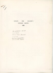
Booklet - Extracts from Bailliere's Victorian Gazetter 1865, Robert Whitworth, 1865
... Robert Whitworth (1831 -1901), an England-born journalist and author worked with the government printer Ferdinand François Balliere in producing gazetteers of the Australian colonies. The first was a gazetteer of Victoria printed in 1865. ...Emerald Museum & Nobelius Heritage Park 5 Crichton Rd Emerald yarra-valley-and-the-dandenong-ranges Robert Whitworth (1831 -1901), an England-born journalist and author worked with the government printer Ferdinand François Balliere in producing gazetteers of the Australian colonies. The first was a gazetteer of Victoria printed in 1865. ...Robert Whitworth (1831 -1901), an England-born journalist and author worked with the government printer Ferdinand François Balliere in producing gazetteers of the Australian colonies. The first was a gazetteer of Victoria printed in 1865. This copied extract from that gazetter provides information about the fauna and flora and geology of Emerald and environs at an early period of European settlement in Victoria.This gazetter extract provides a picture of Emerald and environs as described by a settler in the mid-19th century.Four foolscap pages of information photocopied regarding the Dandenong Ranges and environs. Pages attached with a staple.On first page: ' EXTRACTS FROM BAILLIERE'S / VICTORIAN GAZETTER / 1865 / DANDENONG RANGE / EMERALD / FERN TREE GULLIES / LILYDALE / CORRANWARRABUL / DANDENONG CREEK'robert whitworth, balliere, gazetter, emerald, 1865 -
 Eltham District Historical Society Inc
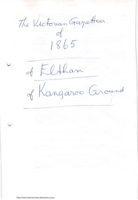
Folder, The Victorian Gazetteer of 1865. Entries for Eltham and Kangaroo Ground, 1999
... The Gazetteer is a geographical dictionary or directory for place names in Victoria. ...Eltham District Historical Society Inc 728 Main Rd Eltham melbourne The Gazetteer is a geographical dictionary or directory for place names in Victoria. ...The Gazetteer is a geographical dictionary or directory for place names in Victoria. Entries for Eltham and Kangaroo Ground have been photocopied. These entries provide physical descriptions, some description of local industry and amenities and more at the time of publication in 1865.3 pages. Copies HG Booklet 118harry gilham collection, gazetteer, eltham, kangaroo ground, 1865 -
 Warrnambool and District Historical Society Inc.
Book, World Publishing Co, Webster Dictionary, 1958
... The supplementary material includes coloured world maps, dictionaries of biography, geography and mythology and information on foreign words and phrases, abbreviations, Scripture and the history of Canada....The supplementary material includes coloured world maps, dictionaries of biography, geography and mythology and information on foreign words and phrases, abbreviations, Scripture and the history of Canada. ...This dictionary is a large tome containing a wealth of information current at the time of publication (1958). The Webster’s Dictionary is an American publication but it was known world-wide and would have been in many households in Australia in the mid 20th century. No information is available on A. M. Archibald (the signature in the front of the book)This book has no known local provenance but is retained as an example of an antiquarian item, a 60 year-old book.This is a large tome of 2129 pages, plus supplements of 160 pages. It has a faded dark green linen cover. The spine and the cover edges are damaged. The wording on the spine and cover are almost indecipherable. Inside the covers are images of a tree with branches representing Indo-European languages. The pages have alphabetical thumb tabs and these are double-sided with gold lettering. The pages contain black and white illustrations and coloured plates. The supplementary material includes coloured world maps, dictionaries of biography, geography and mythology and information on foreign words and phrases, abbreviations, Scripture and the history of Canada.A.M. Archibald Webster’s Dictionary antiquarian books, history of warrnambool -
 Bendigo Historical Society Inc.
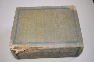
Book - Geographical dictionary
... Published by Bailliere, Regent Street Book Geographical dictionary ...The Gazetteer presents an extensive a to z list of Victorian towns and villages, lakes, rivers and creeks, islands, bays, hills and mountains, runs and other localities and features. Entries include latitude and longitude, populations, proximity to other towns, local industries, coach and mail runs, hotels, churches and schools.Bailliere's Victorian Gazetteer and road guide containing the most recent and accurate information as to every place in the colony. Brown hardcover book, on the spine: Victorian Gazetteer with map 1865. The first and last pages are advertisements. The book has 442 pages listing every place in the colony. The map is not included. Compiled by Robert P. Whitworth. Published by Bailliere, Regent Street Unreadable name on first page and the name of F. Houston in blue pen on first page geographic dictionary, colony of victoria -
 Bendigo Historical Society Inc.
Document - LETTERS AND HISTORICAL RESEARCH INFORMTION: JOHANN MENGE, 1997
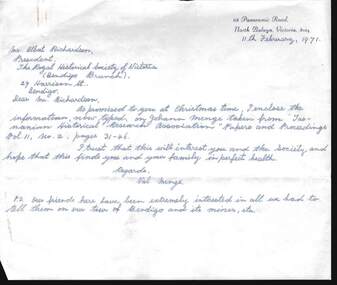
... Includes three letters to A Richardson from Val Menge (wife of possible descendant of Johann Menge) , dated December 19970, Feb 1971 and March 1971; Extract from ''South Australia and its Mines''(1846); Extract from ''Historical studies of Australia & New Zealand Vol 10''; Extract from the ''Australian Dictionary of Biography''; extract from George Stevenson's Journal in ''Royal Geographic Society of Australia - South Australian Branch, Vol 30, p. 62; Extract from ''The history of South Australia pp. 186-187; Extract from letter written by ''The South Australian Register'' (1852); Extract from '' Tasmanian Historical Research Association'' Papers and proceedings Vol 11, No. 2, pp 31 - 46; copy of book review (unknown paper) of ''Opal Men'', with sketch of Johann Menge, who first discovered opal in Australia. ...Includes three letters to A Richardson from Val Menge (wife of possible descendant of Johann Menge) , dated December 19970, Feb 1971 and March 1971; Extract from ''South Australia and its Mines''(1846); Extract from ''Historical studies of Australia & New Zealand Vol 10''; Extract from the ''Australian Dictionary of Biography''; extract from George Stevenson's Journal in ''Royal Geographic Society of Australia - South Australian Branch, Vol 30, p. 62; Extract from ''The history of South Australia pp. 186-187; Extract from letter written by ''The South Australian Register'' (1852); Extract from '' Tasmanian Historical Research Association'' Papers and proceedings Vol 11, No. 2, pp 31 - 46; copy of book review (unknown paper) of ''Opal Men'', with sketch of Johann Menge, who first discovered opal in Australia. ...Letters and historical research information re Johann Menge (1788-1852). Includes three letters to A Richardson from Val Menge (wife of possible descendant of Johann Menge) , dated December 19970, Feb 1971 and March 1971; Extract from ''South Australia and its Mines''(1846); Extract from ''Historical studies of Australia & New Zealand Vol 10''; Extract from the ''Australian Dictionary of Biography''; extract from George Stevenson's Journal in ''Royal Geographic Society of Australia - South Australian Branch, Vol 30, p. 62; Extract from ''The history of South Australia pp. 186-187; Extract from letter written by ''The South Australian Register'' (1852); Extract from '' Tasmanian Historical Research Association'' Papers and proceedings Vol 11, No. 2, pp 31 - 46; copy of book review (unknown paper) of ''Opal Men'', with sketch of Johann Menge, who first discovered opal in Australia. Menge was a mineralogist/geologist with a talent for languages - ''eccentric'' -died in poverty at Forest Creek, 1852.Val & Ted Mengeperson, individual, johann menge -
 Victorian Aboriginal Corporation for Languages
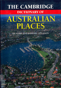
Book, The Cambridge dictionary of Australian Places, 1992
... Victorian Aboriginal Corporation for Languages 33 Saxon Street Brunswick melbourne gazetteer nomenclature maps geography pronunciation maps, pronunciation guides Lists thousands of place names across Australia, giving a detailed account of the name and location, shire etc. The Cambridge dictionary ...Lists thousands of place names across Australia, giving a detailed account of the name and location, shire etc.maps, pronunciation guidesgazetteer, nomenclature, maps, geography, pronunciation -
 City of Stonnington
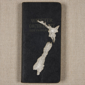
Nicholas Jones, New Zealand, 2015
... New Zealand Map reference: by Captain James Cook (1770) Book sculpted: Webster's Self Pronouncing Dictionary Stonnington contemporary art collection Topography Cartography Atlas Landscape Geography Book Nicholas Jones Sculpture New Zealand Nicholas Jones ...Nicholas Jones uses books and printed paper to make works which question the manner in which books are ‘read’. He employs scalpels and a careful hand to carve and incise, fold, tear and sew his materials, manipulating books and pages in a manner that disrupts narrative structure and creates alternative readings. Old books, subject to his process-driven practice, are reborn as sculptural objects. In 2012 Jones was awarded a Creative Fellowship by the State Library of Victoria. Several years of research into mapping and the history of cartography led to his discovery of Terrarum Orbis Theatrum, considered to be the world’s first true modern atlas, published 1570 in Antwerp, Belgium. Inspired by this tome, Jones deftly carved the topographical Readers Digest, Atlas of Australia (Terra Australis nondum cognita) the larger book displayed here, acquired by Council in 2014. The topographical effect achieved by carving imagined coastline through the book is mirrored by the aerial geographical view of an Australian landscape printed on the book's endpapers. To complement this acquisition, four smaller works were commissioned in 2015. Stonnington’s community is diverse and rich in its heritage; Jones references the four most common ethnic origins of residents of the City of Stonnington as listed in the most recent census data. The coastal outlines of these countries, as represented in significant historical maps, are here embodied in little paper vessels of content and history. As Jones intervenes in the physicality of the books, he transforms them into small yet compelling sculptures that challenge and expand the questions and answers books typically provide.New Zealand Map reference: by Captain James Cook (1770) Book sculpted: Webster's Self Pronouncing Dictionarystonnington contemporary art collection, topography, cartography, atlas, landscape, geography, book, nicholas jones, sculpture