Showing 825 items matching " aerial photo"
-
 Bendigo Military Museum
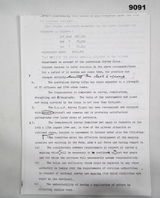
Administrative record - Australian Survey Corps Aerial photo library Finance Report, Australian Survey Corps, 1944?
... Australian Survey Corps Aerial photo library Finance Report...Australian Survey Corps Aerial photo library Finance Report...The paper talks about the storage of aerial photo's and negatives by the Australian Survey Corps and the R.A.A.F....Four A4 pages of typed text Australian Survey Corps Aerial photo library Finance Report Administrative record Australian Survey Corps Aerial photo library Finance Report Australian Survey Corps ...Some front pages are missing. Each page missing some text at the top of each page. The paper talks about the storage of aerial photo's and negatives by the Australian Survey Corps and the R.A.A.F.Four A4 pages of typed textNumerous corrections and additions to original typed text.australian survey corps raaf, royal australian survey corps, rasvy, fortuna, army survey regiment, army svy regt, asr -
 Chelsea & District Historical Society Inc
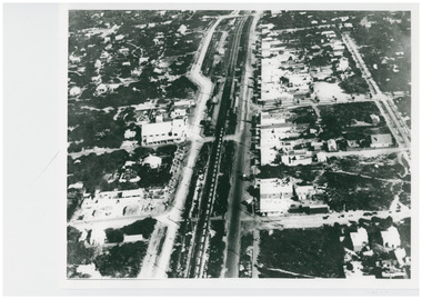
Photograph - Aerial Photo of Chelsea, c 1923
... Aerial Photo of Chelsea......Aerial photo...Black and white aerial photo of Chelsea. ...Photograph Aerial Photo of Chelsea ...Points of interest in the photo are Fox Theatre in Station Street and Masons Theatre on the corner of Chelsea Road and Station Street; Chelsea Railway Station with a goods train going past. Street in photo are Station Street, Chelsea Road, Nepean Highway, Thames Promenade, Bath Street and The Strand. Black and white aerial photo of Chelsea. chelsea, aerial photo, station street, chelsea road, the strand, bath street, fox theatre, masons theatre, chelsea railway station, thames promenade, nepean highway -
 Sunshine and District Historical Society Incorporated
Photograph - Aerial Photo of Sunshine North 1947 / 1948
... Aerial Photo of Sunshine North 1947 / 1948...Aerial Photo of Sunshine North 1947 / 1948 including Braybrook, Sunshine & Albion just south of Ballarat Rd. ...Aerial Photo of Sunshine North 1947 / 1948...Sunshine North Aerial Photograph Aerial Photo of Sunshine North 1947 / 1948 Aerial Photo of Sunshine North 1947 / 1948 including Braybrook, Sunshine & Albion just south of Ballarat Rd. ...Aerial Photo of Sunshine North 1947 / 1948sunshine north, aerial photograph -
 Chelsea & District Historical Society Inc
Photograph - Aerial Photo of Edithvale
... Aerial Photo of Edithvale......Aerial photo...Black and white aerial photo of Edithvale. It shows open paddocks, houses, unmade roads. ...Chelsea & District Historical Society Inc The Chelsea Activity Hub 3-5 Showers Ave Chelsea 3196 melbourne Edithvale Boat house was opened in 1918. Chelsea Aerial photo Edithvale Boat House Edithvale Black and white aerial photo of Edithvale. ...Edithvale Boat house was opened in 1918. Black and white aerial photo of Edithvale. It shows open paddocks, houses, unmade roads. The Edithvale Boat Shed can be seen on the foreshore. chelsea, aerial photo, edithvale boat house, edithvale -
 Chelsea & District Historical Society Inc
Photograph - Aerial Photo of Chelsea, c 1923
... Aerial Photo of Chelsea......Aerial photo...Points of interest in the photo are Fox Theatre, Chelsea Railway Station and the building site of Masons Theatre on the corner of Chelsea Road and Station Street. Mr William Herbert Hansom was a pioneer of aerial...Black and white aerial photo of Chelsea, bordered by Thames Promenade, Balantyne Avenue, Catherine Avenue and Chelsea Road, Station Street, The Strand, Bath Street....Photograph Aerial Photo of Chelsea ...Points of interest in the photo are Fox Theatre, Chelsea Railway Station and the building site of Masons Theatre on the corner of Chelsea Road and Station Street. Mr William Herbert Hansom was a pioneer of aerial photography in Australia.Black and white aerial photo of Chelsea, bordered by Thames Promenade, Balantyne Avenue, Catherine Avenue and Chelsea Road, Station Street, The Strand, Bath Street.W. H. Hansom ("Manders") Aerial Artist, Personally Conducted Flights over Melbourne and Suburbs St James' Building Bourke Street, Melbournechelsea, aerial photo, station street, chelsea road, the strand, bath street, fox theatre, masons theatre, w. h. hansom, chelsea railway station -
 Sunshine and District Historical Society Incorporated
Photograph - Aerial Photo of Sunshine
... Aerial Photo of Sunshine...Aerial Photo of Sunshine showing Spalding, Nettlefolds, Ambulance Station, Massey Ferguson, Post Office & Sunshine Overpass...Aerial Photo of Sunshine showing Spalding, Nettlefolds, Ambulance Station, Massey Ferguson, Post Office & Sunshine Overpass...Sunshine Aerial Photograph Aerial Photo of Sunshine showing Spalding, Nettlefolds, Ambulance Station, Massey Ferguson, Post Office & Sunshine Overpass Aerial Photo of Sunshine showing Spalding, Nettlefolds, Ambulance Station, Massey Ferguson, Post Office & Sunshine Overpass Photograph Aerial Photo of Sunshine ...Aerial Photo of Sunshine showing Spalding, Nettlefolds, Ambulance Station, Massey Ferguson, Post Office & Sunshine Overpasssunshine, aerial photograph -
 Port Melbourne Historical & Preservation Society
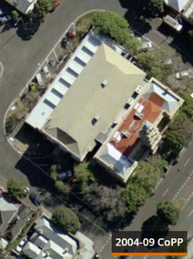
Photograph - Port Melbourne Town Hall - aerial photo Sep 2004, Sep 2004
... Port Melbourne Town Hall - aerial photo Sep 2004...Port Melbourne Town Hall - aerial photo...Port Melbourne Town Hall aerial photo Sep 2004...Port Melbourne Town Hall - aerial photo Port Melbourne Town Hall Built Environment - Civic Port Melbourne Town Hall aerial photo Sep 2004 Photograph Port Melbourne Town Hall - aerial photo Sep 2004 ...Port Melbourne Town Hall - aerial photoPort Melbourne Town Hall aerial photo Sep 2004port melbourne town hall, built environment - civic -
 Port Melbourne Historical & Preservation Society
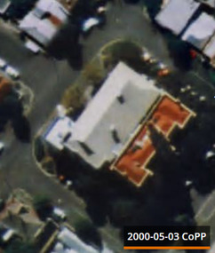
Photograph - Port Melbourne Town Hall - aerial photo 3 May 2000, 3 May 2000
... Port Melbourne Town Hall - aerial photo 3 May 2000...Port Melbourne Town Hall - aerial photo...Port Melbourne Town Hall aerial photo 3 May 2000...Port Melbourne Town Hall - aerial photo Port Melbourne Town Hall Built Environment - Civic Port Melbourne Town Hall aerial photo 3 May 2000 Photograph Port Melbourne Town Hall - aerial photo 3 May 2000 ...Port Melbourne Town Hall - aerial photoPort Melbourne Town Hall aerial photo 3 May 2000port melbourne town hall, built environment - civic -
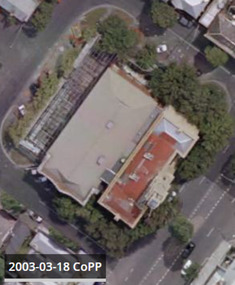 Port Melbourne Historical & Preservation Society
Photograph - Port Melbourne Town Hall - aerial photo 18 Mar 2003, 18 Mar 2003
... Port Melbourne Town Hall - aerial photo 18 Mar 2003...Port Melbourne Town Hall - aerial photo...Port Melbourne Town Hall aerial photo 18 Mar 2003...Port Melbourne Town Hall - aerial photo Port Melbourne Town Hall Built Environment - Civic Port Melbourne Town Hall aerial photo 18 Mar 2003 Photograph Port Melbourne Town Hall - aerial photo 18 Mar 2003 ...Port Melbourne Town Hall - aerial photoPort Melbourne Town Hall aerial photo 18 Mar 2003port melbourne town hall, built environment - civic -
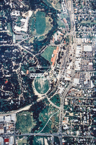
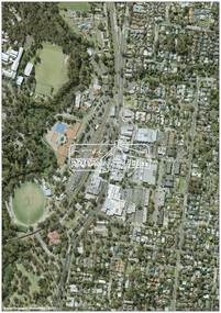 Eltham District Historical Society Inc
Photograph - Digital Photograph, MetroMap, Aerial Photo: Eltham Town Centre, 2021, 2021
... Aerial Photo: Eltham Town Centre, 2021...Aerial Photo...Eltham District Historical Society Inc 728 Main Rd Eltham melbourne Map acquired by Nillumbik Shire Council as part of an investigation into proposed transport upgrades. Aerial Photo eltham town centre Born digital file Aerial Photo: Eltham Town Centre, 2021 Photograph Digital Photograph MetroMap ...Map acquired by Nillumbik Shire Council as part of an investigation into proposed transport upgrades.aerial photo, eltham town centre -
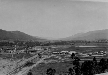
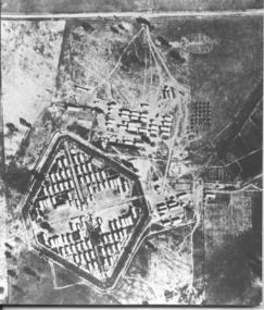 Tatura Irrigation & Wartime Camps Museum
Photograph, Aerial photo of camp 3 1946
... Aerial photo of camp 3 1946...aerial photo of camp 3...Aerial photo of camp 3 1946 Photograph Photograph ...Aerial photograph, taken in 1946 of the Rushworth internment camp.Black and white aerial photograph of camp 3 Rushworth showing layout of the camp.aerial photo of camp 3, taken in 1946, rushworth internment camp, aerial photographs, victorian internment camps -
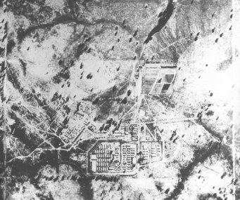 Tatura Irrigation & Wartime Camps Museum
Photograph, camp 1 aerial photo 1946
... camp 1 aerial photo 1946...camp 1 aerial photo 1946...Tatura Irrigation & Wartime Camps Museum 49 Hogan Street Tatura the-murray camp 1 aerial photo 1946 photograph camp 1 aerial photo 1946 Photograph ...camp 1 aerial photo 1946, photograph -
 Charlton Golden Grains Museum Inc
Photograph, Aerial photo of Armstrong St, Charlton, c.1974
... Aerial photo of Armstrong St, Charlton...Aerial photo looking down Armstrong St. Camp street on the left, Shire Hall on the right. ...Black & white aerial photo looking down a broad street that ends in a t-intersection. ...Charlton Golden Grains Museum Inc 1 High Street Charlton goldfields Aerial photo looking down Armstrong St. Camp street on the left, Shire Hall on the right. ...Aerial photo looking down Armstrong St. Camp street on the left, Shire Hall on the right. High St runs across the photo. The Avoca River is visible in the top LH side. The swimming pool and bowling green is above the rive. On High St (from L-R) Dr Surgery, H Bath Chemist, Grocery, Roy Dobson, Hairdresser, Stowe's, Westpac Bank (two storey white building), Dillon's Building, Globe Hotel, Charlton Club, butcher shop, Arundell's shoe shop, Watson's Stock & Station Agency, Bullock's grocery, Williams St (Curtin Ave), Bannon's Butchers, East Charlton Hotel, MB Luth & Co, Lou's cafe. The old sale yards are at the end of Williams Street. Camp St lower side (from L-R) Court House, Police residence, Police Station, Telecom on corner. The photo is thought to be taken from Ossie Sanderson's airplane in 1974.Black & white aerial photo looking down a broad street that ends in a t-intersection. There is a street that comes off to the left about 1/3 of the way up the photo. There is a large building directly opposite this street. In the upper right there is a two storey building with arches on its verandah. In the upper LH side there is a swimming pool and bowling greens.armstrong st charlton, charlton, business, industry, westpac bank, globe hotel, east charlton hotel, dillon building -
 Port Melbourne Historical & Preservation Society
Postcard - Aerial view of piers at Port Melbourne, Aerial photo of Port Melbourne, c. 1922
... Aerial photo of Port Melbourne...Sepia picture postcard, unused, aerial photo showing ships at Port Melbourne: Princes, Station and Town Piers...Port Melbourne Historical & Preservation Society Port Melbourne Town Hall 333 Bay Street Port Melbourne melbourne transport - shipping piers and wharves - station pier piers and wharves - princes pier piers and wharves - town pier Sepia picture postcard, unused, aerial photo showing ships at Port Melbourne: Princes, Station and Town Piers Aerial photo of Port Melbourne Postcard Aerial view of piers at Port Melbourne Valentine & Sons Publishing Co Ltd ...Sepia picture postcard, unused, aerial photo showing ships at Port Melbourne: Princes, Station and Town Pierstransport - shipping, piers and wharves - station pier, piers and wharves - princes pier, piers and wharves - town pier -
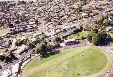 Stawell Historical Society Inc
Photograph, Central Park -- Aerial Photo 1995
... Central Park -- Aerial Photo 1995...Central Park (Aerial Photo) 1995...Stawell Historical Society Inc 46 Longfield St Stawell grampians Central Park (Aerial Photo) 1995 stawell sport Central Park -- Aerial Photo 1995 Photograph ...Central Park (Aerial Photo) 1995stawell sport -
 Stawell Historical Society Inc
Photograph, Stawell Gold Mine -- Aerial photo 1998
... Stawell Gold Mine -- Aerial photo 1998...Stawell Gold Mine 1998 - Aerial photo...Stawell Historical Society Inc 46 Longfield St Stawell grampians Stawell Gold Mine 1998 - Aerial photo Stawell Stawell Gold Mine -- Aerial photo 1998 Photograph ...Stawell Gold Mine 1998 - Aerial photostawell -
 Bendigo Historical Society Inc.
Photograph - HARRY BIGGS COLLECTION: AERIAL PHOTO OF EAGLEHAWK
... HARRY BIGGS COLLECTION: AERIAL PHOTO OF EAGLEHAWK...... Aerial photo of Eaglehawk...Photograph HARRY BIGGS COLLECTION: AERIAL PHOTO OF EAGLEHAWK ...Photograph. Harry Biggs Collection. A black & white overhead photo of Eaglehawk. It clearly shows the football ground, Canterbury Park, Town Hall precinct.place, streetscape, aerial view of eaglehawk, harry biggs collection, aerial photo of eaglehawk -
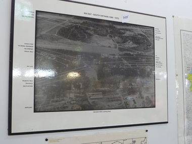 National Vietnam Veterans Museum (NVVM)
Photograph, Aerial photo of Nui Dat Base
... Aerial photo of Nui Dat Base...Black & white aerial photo of "Nui Dat - vietnam (1966 - 1972)" oblique view looking north. ...Arrows point to buildings which are identified in the borders of the photo. Aerial photo of Nui Dat Base Photograph Photograph ...Black & white aerial photo of "Nui Dat - vietnam (1966 - 1972)" oblique view looking north. Arrows point to buildings which are identified in the borders of the photo.nui dat base - buildings -
 Eltham District Historical Society Inc
Photograph (item) - Aerial Photograph, Aerial Photo: Shire of Eltham War Memorial, Kangaroo Ground, Jan 1951
... Aerial Photo: Shire of Eltham War Memorial, Kangaroo Ground...1951 Aerial photo 1423-110 Run 10 showing the Shire of Eltham War Memorial at centre of image with the newly constructed Caretaker's cottage....Eltham District Historical Society Inc 728 Main Rd Eltham melbourne 1951 Aerial photo 1423-110 Run 10 showing the Shire of Eltham War Memorial at centre of image with the newly constructed Caretaker's cottage. ...1951 Aerial photo 1423-110 Run 10 showing the Shire of Eltham War Memorial at centre of image with the newly constructed Caretaker's cottage.aerial photographs, garden hill farm, kangaroo ground, memorial park, shire of eltham war memorial -
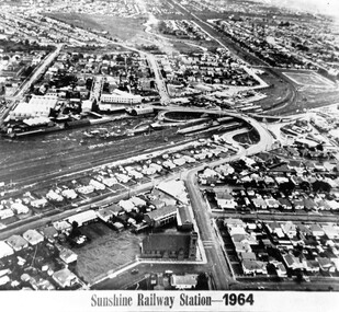 Sunshine and District Historical Society Incorporated
Photograph - Sunshine Railway Station 1964 Aerial Photo, 1964
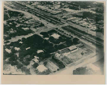
... Sunshine Railway Station 1964 Aerial Photo...Sunshine Railway Station 1964 Aerial Photo...Besides railway station shows Catholic church lower centre and residential area also left ramp of overpass The municipal offices feature, top area original Sunshine golf course centre right Old postal office and Kororoit Creek Houses removed in 1994 for road work of 1994 to 1995 Sunshine Railway Station 1964 Aerial Photo Photograph Sunshine Railway Station 1964 Aerial Photo ...Photograph mounted on card of the Sunshine Railway Station. Besides railway station shows Catholic church lower centre and residential area also left ramp of overpass The municipal offices feature, top area original Sunshine golf course centre right Old postal office and Kororoit Creek Houses removed in 1994 for road work of 1994 to 1995sunshine railway station, railway -
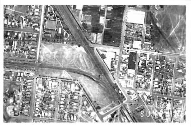 Sunshine and District Historical Society Incorporated
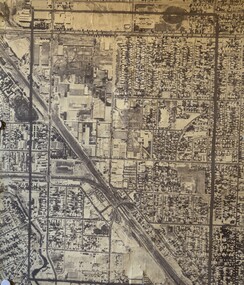
Photograph - Sunshine CBD Aerial Photo, 1920's
... Sunshine CBD Aerial Photo...Sunshine CBD Aerial Photo|Sunshine North & Braybrook north of Ballarat Rd|Sunshine south of Ballarat Rd...Sunshine CBD Aerial Photograph Sunshine CBD Aerial Photo|Sunshine North & Braybrook north of Ballarat Rd|Sunshine south of Ballarat Rd Collection of Black and White Aerial Photographs of Sunshine and Braybrook Photograph Sunshine CBD Aerial Photo ...Sunshine CBD Aerial Photo|Sunshine North & Braybrook north of Ballarat Rd|Sunshine south of Ballarat Rdsunshine cbd, aerial photograph -
 Kiewa Valley Historical Society
Photo - Aerial photo of Mt Beauty
... Photo - Aerial photo of Mt Beauty...Small sepia aerial photo of Mt Beauty taken from Big Hill...Kiewa Valley Historical Society Mount Beauty Information Centre 31 Bogong High Plains Rd Mt Beauty high-country Small sepia aerial photo of Mt Beauty taken from Big Hill Photo - Aerial photo of Mt Beauty ...Small sepia aerial photo of Mt Beauty taken from Big Hill -
Port Melbourne Historical & Preservation Society
Plan - Map and aerial photo of Port Melbourne, c. 1990
... Map and aerial photo of Port Melbourne...Map and Aerial photo of Port Melbourne with handwritten annotations detailing the location of various buildings, trotting tracks, etc which previously existed in Port Melbourne (recollections only)....Plan Map and aerial photo of Port Melbourne ...Notations made as a result of conversations Anne had in the early 1990s with an elderly male resident of Port Melbourne.Map and Aerial photo of Port Melbourne with handwritten annotations detailing the location of various buildings, trotting tracks, etc which previously existed in Port Melbourne (recollections only).fishermans bend -
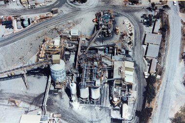
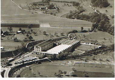 Bendigo Historical Society Inc.
Photograph - HANRO COLLECTION: AERIAL PHOTO OF FACTORY
... HANRO COLLECTION: AERIAL PHOTO OF FACTORY...Photograph: black and white aerial photo of factory ( Switzerland ? ) Large industrial site situated in rural setting. ...Photograph HANRO COLLECTION: AERIAL PHOTO OF FACTORY ...Photograph: black and white aerial photo of factory ( Switzerland ? ) Large industrial site situated in rural setting. Postcard type photo - on back 'Hanro' Handschin & Ronus, SA, Liestal.unknownorganization, business, hanro, hanro, manufacturing -
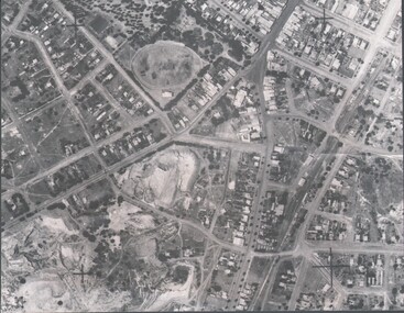
Bendigo Historical Society Inc.
Photograph - AERIAL PHOTO FORTUNA VILLA
... AERIAL PHOTO FORTUNA VILLA...Large black and white aerial photo taken looking north, foreground Fortuna Villa, on right side site where now is St John hospital, top left garden gully oval. ...There are three copies (one sepia colour). Photograph AERIAL PHOTO FORTUNA VILLA ...Large black and white aerial photo taken looking north, foreground Fortuna Villa, on right side site where now is St John hospital, top left garden gully oval. There are three copies (one sepia colour).bendigo, streetscape, aerial view -
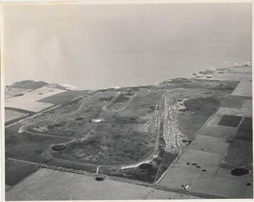 Phillip Island and District Historical Society Inc.
Photograph, J D Payens, Aerial photo of Grand prix track and painting of 1932 Grand Prix
... Aerial photo of Grand prix track and painting of 1932 Grand Prix...Phone: XL 3144 Black & White aerial view of the Phillip Island Grand Prix Race Track with Bass Strait in the background and painting of 1932 Grand Prix Aerial photo of Grand prix track and painting of 1932 Grand Prix Photograph Photograph J D Payens ...The Circuit was built in the 1950's and opened in 1956. The circuit was closed in 1962 due to lack of finance for repair work to the track. In 1964 Len Lukey purchased the cirtuit and reopened in 1967, but once again was closed in 1978 as not suitable for modern racing. It was used only for Historic Rallies and the like until 1982. In 1985 The Circuit was purchsed by Placetac Pty Ltd. The Circuit was refurbished in 1988. In 1989 The Australian Motorcycle Grand Prix - 1st World Championship Round - was held at the Circuit on 9th April. 2004 the Circuit and surrounding land was purchased by The Linfox Group who still own it to this day (8/10/2016).Black & White aerial view of the Phillip Island Grand Prix Race Track with Bass Strait in the background and painting of 1932 Grand PrixJ. D. Payne - Commercial Photographer, Rice Street, Moorabbin. Phone: XL 3144phillip island g p circuit, grand prix circuit phillip island, len lukey, linfox group, jean parle, bill thompson, keith riordan, bugatti, 1932 grand prix -
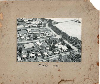 Phillip Island and District Historical Society Inc.
Photograph, Aerial photo Cowes 1931, 1931
... Aerial photo Cowes 1931...Aerial photo Cowes 1931 Photograph ...Cowes in the era of guesthouses with large tennis courts and open space.HistoricalBlack & white photo mounted on cardboard of Cowes jetty with boats, Thompson Ave, The Esplanade, Isle of Wight, The Continental Guesthouse, Erewhon Guesthouse, Yackatoon Guesthouse.Cowes 1931cowes, aerial photos, jetty, isle of wight, continental, yackatoon, guesthouses, bass avenue -
 Eltham District Historical Society Inc
Slide - Photograph, Aerial Photo (c.1987): Main Road, Eltham from Pitt Street to Elsa Court, c.Aug. 1990
... Aerial Photo (c.1987): Main Road, Eltham from Pitt Street to Elsa Court...photos and recent images ranging from the suburban streets of Eltham and Montmorency to the mountain roads of Kinglake. In the byways category are views of some iof the Shire's bicycle paths including then recently completed sections of the Main Yarra Trail at Lower Plenty. infrastructure roads Aerial photographs Alistair Knox Park Bridge Street Central Park Diamond Street Elsa Court Eltham Eltham Common Eltham Railway Station Eltham Town Park Main Road Pitt Street 35mm colour positive transparency (1 of 37) Mount - Agfachrome Agfa CS System black 8 dots Aerial Photo (c.1987): Main Road, Eltham from Pitt Street to Elsa Court Slide Photograph ...Part of a presentation, "Roads and Byways of the Shire of Eltham", by Russell Yeoman to the 12 September 1990 Society meeting. Slides shown included copies of old photos and recent images ranging from the suburban streets of Eltham and Montmorency to the mountain roads of Kinglake. In the byways category are views of some iof the Shire's bicycle paths including then recently completed sections of the Main Yarra Trail at Lower Plenty.35mm colour positive transparency (1 of 37) Mount - Agfachrome Agfa CS System black 8 dotsinfrastructure, roads, aerial photographs, alistair knox park, bridge street, central park, diamond street, elsa court, eltham, eltham common, eltham railway station, eltham town park, main road, pitt street -
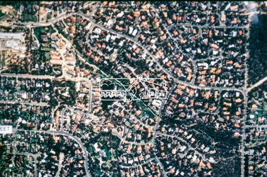 Eltham District Historical Society Inc
Slide - Photograph, Aerial Photo (c.1987): Woodridge Estate, Eltham, c.Aug. 1990
... Aerial Photo (c.1987): Woodridge Estate, Eltham...photos and recent images ranging from the suburban streets of Eltham and Montmorency to the mountain roads of Kinglake. In the byways category are views of some iof the Shire's bicycle paths including then recently completed sections of the Main Yarra Trail at Lower Plenty. infrastructure roads aerial photographs eltham Housing estate Woodridge Estate 35mm colour positive transparency (1 of 37) Mount - Agfachrome Agfa CS System black 8 dots Aerial Photo (c.1987): Woodridge Estate, Eltham Slide Photograph ...Part of a presentation, "Roads and Byways of the Shire of Eltham", by Russell Yeoman to the 12 September 1990 Society meeting. Slides shown included copies of old photos and recent images ranging from the suburban streets of Eltham and Montmorency to the mountain roads of Kinglake. In the byways category are views of some iof the Shire's bicycle paths including then recently completed sections of the Main Yarra Trail at Lower Plenty.35mm colour positive transparency (1 of 37) Mount - Agfachrome Agfa CS System black 8 dotsinfrastructure, roads, aerial photographs, eltham, housing estate, woodridge estate -
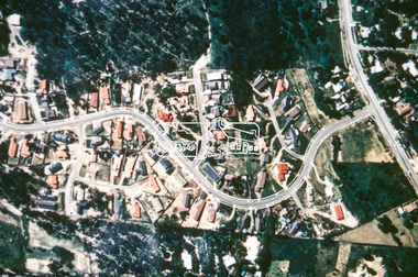 Eltham District Historical Society Inc
Slide - Photograph, Aerial Photo (c.1987): Main Road and Leanne Drive, Eltham, c.Aug. 1990
... Aerial Photo (c.1987): Main Road and Leanne Drive, Eltham...photos and recent images ranging from the suburban streets of Eltham and Montmorency to the mountain roads of Kinglake. In the byways category are views of some iof the Shire's bicycle paths including then recently completed sections of the Main Yarra Trail at Lower Plenty. infrastructure roads aerial photographs eltham Leanne Drive Main Road 35mm colour positive transparency (1 of 37) Mount - Agfachrome Agfa CS System black 8 dots Aerial Photo (c.1987): Main Road and Leanne Drive, Eltham Slide Photograph ...Part of a presentation, "Roads and Byways of the Shire of Eltham", by Russell Yeoman to the 12 September 1990 Society meeting. Slides shown included copies of old photos and recent images ranging from the suburban streets of Eltham and Montmorency to the mountain roads of Kinglake. In the byways category are views of some iof the Shire's bicycle paths including then recently completed sections of the Main Yarra Trail at Lower Plenty.35mm colour positive transparency (1 of 37) Mount - Agfachrome Agfa CS System black 8 dotsinfrastructure, roads, aerial photographs, eltham, leanne drive, main road