Showing 244 items matching " aerial photography"
-
 Bendigo Military Museum
Article - Aerial photography Diapositive Filter Plate, circa 1960
... Aerial photography Diapositive Filter Plate...Aerial photography Diapositive Filter Plate...Aerial photography glass plate filter used in the production of aerial photography for mapping...Bendigo Military Museum 37 - 39 Pall Mall Bendigo goldfields Aerial photography glass plate filter used in the production of aerial photography for mapping Royal Australian Survey Corps RASvy Fortuna Army Survey Regiment Army Svy Regt ASR Wooden box, lacquered, hinges and clasps, blue felt lined, glass plate Aerial photography Diapositive Filter Plate Article Aerial photography Diapositive Filter Plate ...Aerial photography glass plate filter used in the production of aerial photography for mappingWooden box, lacquered, hinges and clasps, blue felt lined, glass plateroyal australian survey corps, rasvy, fortuna, army survey regiment, army svy regt, asr -
 Bendigo Military Museum
Administrative record - Division of National Mapping - Specification for Vertical Aerial Photography, Division of National Mapping, 1963
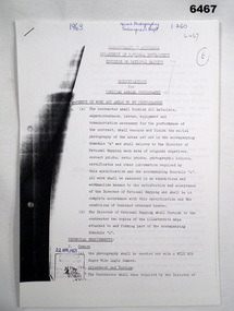
... Division of National Mapping - Specification for Vertical Aerial Photography...Division of National Mapping - Specification for Vertical Aerial Photography...This is a Specification for Aerial Photography acquisition and is written for civilian contract work....This is a Specification for Aerial Photography acquisition and is written for civilian contract work. ...Commonwealth of Australia, Department of Defence of National Development, Division of National Mapping Specification. This is a Specification for Aerial Photography acquisition and is written for civilian contract work.8 x A4 poor photocopies of typed pagesroyal australian survey corps, rasvy, fortuna, army survey regiment, army svy regt, asr -
 Bendigo Military Museum
Administrative record - AHQ Survey Regiment - Tests on stability of duplicate Aerial Photography negatives 1959, AHQ Survey Regiment, 8 Dec 1959
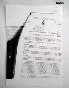
... AHQ Survey Regiment - Tests on stability of duplicate Aerial Photography negatives 1959...AHQ Survey Regiment - Tests on stability of duplicate Aerial Photography negatives 1959...Tests on the stability of Duplicated Aerial Photography negatives. Tests were carried out using 3 x units of 2 x models from both original and duplicate films. ...Typed text and incomplete AHQ Survey Regiment - Tests on stability of duplicate Aerial Photography negatives 1959 Administrative record AHQ Survey Regiment - Tests on stability of duplicate Aerial Photography negatives 1959 AHQ Survey Regiment ...Tests on the stability of Duplicated Aerial Photography negatives. Tests were carried out using 3 x units of 2 x models from both original and duplicate films. These were all brought to a scale of 1;25,000 and horizontalized on common points and approximately 250 spot heights read on each unit.1 x A4 poorly photocopied Report. Typed text and incompleteroyal australian survey corps, rasvy, fortuna, army survey regiment, army svy regt, asr -
 Bendigo Military Museum
Photograph - Aerial Photography - Mohogany Ship Search Warrnambool Victoria, Victorian Lands Department, 3.1.1981
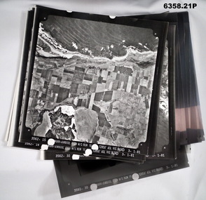
... Aerial Photography - Mohogany Ship Search Warrnambool Victoria...Aerial Photography - Mohogany Ship Search Warrnambool Victoria...Images are Numbered 3562- 15,16,17,18,19, 29 and 30. Aerial Photography - Mohogany Ship Search Warrnambool Victoria Photograph Aerial Photography - Mohogany Ship Search Warrnambool Victoria Victorian Lands Department ...These Victorian Lands Dept Aerial Photographs were acquired by the Army Survey Regiment to help locate a Mohogany Ship wreck near Warrnambool Victoria as part of a unit Regimental Training ExerciseSeven Aerial photographic Prints and Film Negatives and positives of the same images. Images are Numbered 3562- 15,16,17,18,19, 29 and 30.royal australian survey corps, rasvy, fortuna, army survey regiment, army svy regt, asr -
 Bayside Gallery - Bayside City Council Art & Heritage Collection
Photograph - type C photograph, Newmark Aerial Photography, Kamesburgh, North Road, Brighton, 1996
... ...Newmark Aerial Photography...Newmark Aerial Photography...Bayside Gallery - Bayside City Council Art & Heritage Collection Corner Wilson and Carpenter Streets Brighton melbourne Kamesburgh North Road Brighton Historic House Aerial Photograph Newmark Aerial Photography ANZAC Hostel William Kerr Thomson Lloyd Tayler Italianate Streets Kamesburgh, North Road, Brighton Photograph type C photograph Newmark Aerial Photography ...kamesburgh, north road, brighton, historic house, aerial, photograph, newmark aerial photography, anzac hostel, william kerr thomson, lloyd tayler, italianate, streets -
 Bayside Gallery - Bayside City Council Art & Heritage Collection
Photograph - type C photograph, Newmark Aerial Photography, Billilla, Halifax Street, Brighton, 1996
... ...newmark aerial photography...Newmark Aerial Photography...Bayside Gallery - Bayside City Council Art & Heritage Collection Corner Wilson and Carpenter Streets Brighton melbourne brighton historic house aerial photograph newmark aerial photography streets Billilla Weatherly William Weatherly Smith and Johnson Walter Richmond Butler Halifax Street Billilla, Halifax Street, Brighton Photograph type C photograph Newmark Aerial Photography ...brighton, historic house, aerial, photograph, newmark aerial photography, streets, billilla, weatherly, william weatherly, smith and johnson, walter richmond butler, halifax street -
 Bayside Gallery - Bayside City Council Art & Heritage Collection
Photograph - type C photograph, Newmark Aerial Photography, Brighton Town Hall, Wilson Street, Brighton, 1996
... ...newmark aerial photography...Newmark Aerial Photography...Bayside Gallery - Bayside City Council Art & Heritage Collection Corner Wilson and Carpenter Streets Brighton melbourne brighton aerial photograph newmark aerial photography streets Brighton Town Hall Brighton Library Brighton Court House Court House Library Gardens Wilson Street Carpenter Street Boxshall Street Khyatt's Hotel Council Chambers Brighton Police Station Brighton Town Hall, Wilson Street, Brighton Photograph type C photograph Newmark Aerial Photography ...brighton, aerial, photograph, newmark aerial photography, streets, brighton town hall, brighton library, brighton court house, court house, library, gardens, wilson street, carpenter street, boxshall street, khyatt's hotel, council chambers, brighton police station -
 Moorabbin Air Museum
Manual (Item) - Techniques Of Oblique Aerial Photography Of Agricultural Field Trials
... Techniques Of Oblique Aerial Photography Of Agricultural Field Trials...RAAF Manual Techniques Of Oblique Aerial Photography Of Agricultural Field Trials ...Description: 1 page. Published by Flight International. Published 16/3/1985. Single Page Extract from Flight International Magazine - First Flight of Locally Assembled F/A-18 Hornet Level of Importance: World. RAAF -
Beechworth Honey Archive
Map- Beechworth
... ...Aerial Photography...Compiled from 1972 aerial photography. Printed in 1977....Beechworth Honey Archive 87 Ford Street Beechworth high-country Compiled from 1972 aerial photography. Printed in 1977. Map Beechworth Wooragee Reids Creek Woolshed Falls Lake Kerford Aerial Photography Paper Beechworth Honey Map labelled Reids Creek. ...Compiled from 1972 aerial photography. Printed in 1977.Map centred on Beechworth. SHows Beechworth toen, Wooragee, Reids Creek, Woolshed Falls and Lake Kerford. Scale 1:25,000 Printed colour on paper.Map labelled Reids Creek. No. 8225-3-1.map, beechworth, wooragee, reids creek, woolshed falls, lake kerford, aerial photography, paper, beechworth honey -
Beechworth Honey Archive
Map- Eldorado
... ...Aerial Photography...Compiled from 1971 aerial photography. Printed in 1978....Beechworth Honey Archive 87 Ford Street Beechworth high-country Compiled from 1971 aerial photography. Printed in 1978. Map Eldorado Reedy Creek Dredge Monument Hill Aerial Photography Paper Beechworth Honey Map labelled Eldorado. ...Compiled from 1971 aerial photography. Printed in 1978.Map shows Eldorado town, Reedy Creek, abandoned gold dredge and Monument Hill. Scale 1:25,000. Printed colour on paper.Map labelled Eldorado. No. 8225-3-4map, eldorado, reedy creek, dredge, monument hill, aerial photography, paper, beechworth honey -
Beechworth Honey Archive
Map- Everton
... Aerial...Photography...Map compiled from 1975 aerial photography. Printed in 1979....Beechworth Honey Archive 87 Ford Street Beechworth high-country Map compiled from 1975 aerial photography. Printed in 1979. Map Everton Ovens River Bright Railway Aerial Photography Paper Beechworth Honey Map labelled Everton. ...Map compiled from 1975 aerial photography. Printed in 1979.Map shows Everton, Ovens River, Beechworth- Wangaratta Rd, former Wangaratta- Bright railway. Scale 1:25,000. Printed colour on paper.Map labelled Everton. No. 8225-3-3.map, everton, ovens river, bright, railway, aerial, photography, paper, beechworth honey -
 Ringwood and District Historical Society
Photograph, Aerial Views of Eastland Precinct, Ringwood, Victoria - circa 1990
... Aerial Photography by R.J. Moss....Ringwood and District Historical Society 125A Warrandyte Road Ringwood North melbourne Aerial Photography by R.J. Moss. Two colour aerial photographs overlooking commercial area of Ringwood centred on Eastland shopping precinct (prior to Stage 2 extension proposed to commence in 1992). ...Two colour aerial photographs overlooking commercial area of Ringwood centred on Eastland shopping precinct (prior to Stage 2 extension proposed to commence in 1992).Aerial Photography by R.J. Moss. -
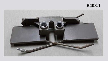 Bendigo Military Museum
Instrument - Universal Stereoscope, 1940
... It was used extensively by members of the Australian Survey Corps during WWII in many theatres of War for viewing and annotating aerial photography. Item 6205.6P, photograph 6205.1P shows the Universal Stereoscope in use by the Australian Survey Corps annotating aerial photography....The Universal Stereoscope was used to view overlapping stereo aerial photography in three dimensions (3D). It consists of magnifying lenses, an optical train including glass prisms and mirrors that are protected by sliding metal covers all suspended on a pair of fold out adjustable legs. ...It was used extensively by members of the Australian Survey Corps during WWII in many theatres of War for viewing and annotating aerial photography. Item 6205.6P, photograph 6205.1P shows the Universal Stereoscope in use by the Australian Survey Corps annotating aerial photography. ...The Universal Stereoscope was used to view overlapping stereo aerial photography in three dimensions (3D). It consists of magnifying lenses, an optical train including glass prisms and mirrors that are protected by sliding metal covers all suspended on a pair of fold out adjustable legs. The stereoscope is coloured military olive drab green. This Universal Stereoscope was produced in Australia in 1940 for Military use. It was originally produced with a timber protecting carry box that is missing. It was used extensively by members of the Australian Survey Corps during WWII in many theatres of War for viewing and annotating aerial photography. Item 6205.6P, photograph 6205.1P shows the Universal Stereoscope in use by the Australian Survey Corps annotating aerial photography.The Universal Stereoscope was used to view overlapping stereo aerial photography in three dimensions (3D). It consists of magnifying lenses, an optical train including glass prisms and mirrors that are protected by sliding metal covers all suspended on a pair of fold out adjustable legs. The stereoscope is coloured military olive drab green."DC-1940 Serial No 550", "D V D", "Made in Australia" Plate on the underside reads " This stereoscope was donated to the Ex Fortuna Survey Association by the Eaglehawk Recycle Shop February 2015"royal australian survey corps, rasvy, fortuna, army survey regiment, army svy regt, asr -
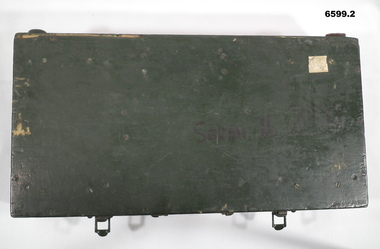 Bendigo Military Museum
Instrument - Universal Stereoscope - boxed, 1940
... It was used extensively by members of the Australian Army Survey Corps during WWII in many theatres of war for viewing and annotating aerial photography. See also photograph at 6205.6P. 6205.1P shows the Universal Stereoscope in use by Royal Australian Survey Corps annotating Aerial Photography....The Universal Stereoscope was used to view overlapping stereo aerial photography in three dimensions (3D). It consists of magnifying lenses, an optical train including glass prisms and mirrors that are protected by sliding metal covers, all suspended on a pair of fold out adjustable legs. ...It was used extensively by members of the Australian Army Survey Corps during WWII in many theatres of war for viewing and annotating aerial photography. See also photograph at 6205.6P. 6205.1P shows the Universal Stereoscope in use by Royal Australian Survey Corps annotating Aerial Photography. ...The Universal Stereoscope was used to view overlapping stereo aerial photography in three dimensions (3D). It consists of magnifying lenses, an optical train including glass prisms and mirrors that are protected by sliding metal covers, all suspended on a pair of fold out adjustable legs. The Universal Stereoscope was produced in Australia in 1940 for military use and has its protective wooden box. It was used extensively by members of the Australian Army Survey Corps during WWII in many theatres of war for viewing and annotating aerial photography. See also photograph at 6205.6P. 6205.1P shows the Universal Stereoscope in use by Royal Australian Survey Corps annotating Aerial Photography.6599.1 Wooden Box that contains a Universal Stereoscope. 6599.2 Open Wooden Box showing a folded Universal Stereoscope. A dark green wooden box containing a Universal Stereoscope with spare mirrors. The Universal Stereoscope was used to view overlapping stereo aerial photography in three dimensions (3D). It consists of magnifying lenses, an optical train including glass prisms and mirrors that are protected by sliding metal covers, all suspended on a pair of fold out adjustable legs. The stereoscope is painted a dark green colour."DC 1940" "Serial (Number) - 239 D>D"royal australian survey corps, rasvy, fortuna, army survey regiment, army svy regt -
University of Melbourne, Burnley Campus Archives
Plan, Maplist: Catalogue of Victorian maps, 1984
... Includes: Geographic, Geological Planimetric, Aerial Photography, Photo Maps....Includes: Geographic, Geological Planimetric, Aerial Photography, Photo Maps. Maplist: Catalogue of Victorian maps Plan ...Brochure showing all standard series mapping in Victoria available from Map Sales Centre as at October 1984. Includes: Geographic, Geological Planimetric, Aerial Photography, Photo Maps.maps, catalogue -
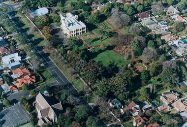
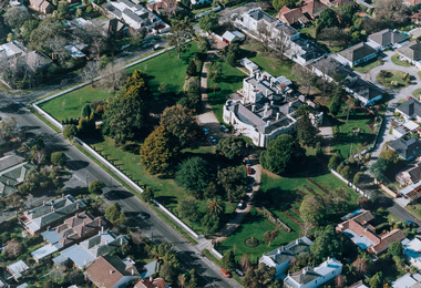
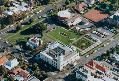
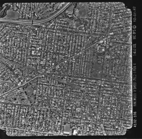 Kew Historical Society Inc
Photograph - Aerial photograph: City of Kew No.1/6, Department of Property & Services (Victoria), 12/12/1987
... aerial photography...Aerial photographs, of which the Society has a number in its collection, allow researchers to identify changes in urban infrastructure and demographics over time aerial photography aerial photograph -- kew (vic.) 4132-106 Ringwood M'Sheet 7922-3 Run 4 5600'ASL Vic DPS © 12-12-87 Aerial photograph of a part of Kew, taken by photographers employed by the Victorian Department of Property and Services in December 1987. ...One of a series of six small square black and white aerial photographs of Kew taken and produced by the Victorian Department of Property Services.Aerial photographs, of which the Society has a number in its collection, allow researchers to identify changes in urban infrastructure and demographics over timeAerial photograph of a part of Kew, taken by photographers employed by the Victorian Department of Property and Services in December 1987.4132-106 Ringwood M'Sheet 7922-3 Run 4 5600'ASL Vic DPS © 12-12-87aerial photography, aerial photograph -- kew (vic.) -
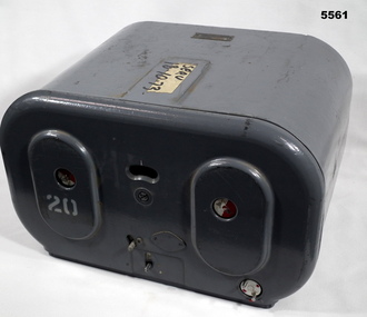 Bendigo Military Museum
Magazine - MAGAZINE, FILM, Williamson Manufacturing Co Ltd
... Aerial Photography...This type of camera was used in Spitfires, Mosquitos, Avro Lincolns and Canberra aircraft. Aerial Photography Magazine WW2 RAAF Top has “serv 18-10-73” The number '20' has been stenciled on two surfaces. ...This photographic magazine attaches to the gear box universal ( see cat 4531). As an assembly, the type F22 aerial camera came into RAF and RAAF service c1942. It was used by the RAF over Europe and by the RAAF extensively through the Sth. West Pacific area of operations, during WW2. This type of camera was used through the Vietnam war up to the early 1980's. The F22 camera assembly when mounted in the reliable Canberra aircraft, did aerial survey work in PNG, Indonesia, Malaysia and Sumatra and the Australian mainland. This type of camera was used in Spitfires, Mosquitos, Avro Lincolns and Canberra aircraft.This is a heavy metal container painted in a grey colour. The label is on the top. One side has two enlarged oval sections. in those two ovals is one hole of 22 mm diameter. In those holes is a disc painted half red and half white. Below the ovals are two levers connected to the internal mechanism. Bottom RHS has a disc with 2 pins, red dots are printed on it. Nearly level with the top of ovals is a kidney shaped hole. In that hole is a rotating disc with graduations and numbers. the action side of magazine has a rectangular opening size 83/4" x 7/16". It is covered with a black soft material.Top has “serv 18-10-73” The number '20' has been stenciled on two surfaces.aerial photography, magazine, ww2, raaf -
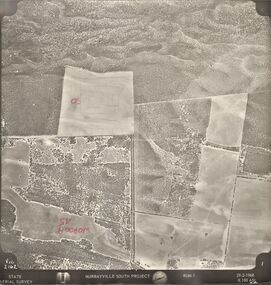 Bendigo Historical Society Inc.
Photograph - MURRAYVILLE SOUTH PROJECT
... ... aerial photography...History House 11 Mackenzie Street Bendigo goldfields BHS Collection PHOTOGRAPH Aerial murrayville south project photos Murrayville South Project State Aerial Survey surveys Murrayville photographs photography aerial photography State Aerial Survey. ...BHS CollectionState Aerial Survey. A set of aerial surveys related to the Murrayville South Project. Run 1. Vic. 2162. 29-2-1968. 53 photos.photograph, aerial, murrayville south project, photos, murrayville south project, state aerial survey, surveys, murrayville, photographs, photography, aerial photography -
Glenelg Shire Council Cultural Collection
Photograph - Photograph - aerial view of Portland, c. 1954
... ... aerial photography...Glenelg Shire Council Cultural Collection History House Cliff Street Portland great-ocean-road Port of Portland Archives aerial photography Portland Harbour south west coastline Front: '607 - 93 ' - handwritten, white, border 'RUN - 6 PORTLAND', printed, white, border Black and white aerial photograph of coastline around Portland. ...Black and white aerial photograph of coastline around Portland. Black border, scale all sides, 5 rows of 3 't' at regular intervals. 60/40 land to ocean.Front: '607 - 93 ' - handwritten, white, border 'RUN - 6 PORTLAND', printed, white, borderport of portland archives, aerial photography, portland harbour, south west coastline -
Glenelg Shire Council Cultural Collection
Photograph - Photograph - aerial view of Glenelg River, n.d
... aerial photography...Glenelg Shire Council Cultural Collection History House Cliff Street Portland great-ocean-road aerial photography Glenelg Shire Glenelg River Coloured photograph of Glenelg River from air. ...Coloured photograph of Glenelg River from air.aerial photography, glenelg shire, glenelg river -
Glenelg Shire Council Cultural Collection
Photograph - Photograph - aerial view of Portland, c. 1954
... aerial photography...Glenelg Shire Council Cultural Collection History House Cliff Street Portland great-ocean-road aerial photography central Portland Portland Harbour south west coastline Front: '607 -101' - handwritten, white, lower border. ...Black and white aerial photograph of coastline around Portland. Black border, scale all sides, 5 rows of 3 't' at regular intervalsFront: '607 -101' - handwritten, white, lower border. 'Run 5' 'PORTLAND'. printed, white lower border.aerial photography, central portland, portland harbour, south west coastline -
Glenelg Shire Council Cultural Collection
Photograph - Photograph - aerial view of Portland, c. 1954
... aerial photography...Glenelg Shire Council Cultural Collection History House Cliff Street Portland great-ocean-road aerial photography central Portland Portland Harbour south west coastline Front: '607 -86 ' - handwritten, white, border 'RUN 6- PORTLAND', printed, white, border Black and white aerial photograph of coastline around Portland. ...Black and white aerial photograph of coastline around Portland. Black border, scale all sides, 5 rows of 3 't' at regular intervals. Very small section of ocean, bottom left.Front: '607 -86 ' - handwritten, white, border 'RUN 6- PORTLAND', printed, white, borderaerial photography, central portland, portland harbour, south west coastline -
Glenelg Shire Council Cultural Collection
Photograph - Photograph - aerial view of Portland, c. 1954
... aerial photography...Glenelg Shire Council Cultural Collection History House Cliff Street Portland great-ocean-road aerial photography central Portland Portland Harbour south west coastline Front: '607 - 87 ' - handwritten, white, border 'RUN - 6 PORTLAND', printed, white, border Black and white aerial photograph of coastline around Portland. ...Black and white aerial photograph of coastline around Portland. Black border, scale all sides, 5 rows of 3 't' at regular intervals. Similar to 8468, more ocean visibleFront: '607 - 87 ' - handwritten, white, border 'RUN - 6 PORTLAND', printed, white, borderaerial photography, central portland, portland harbour, south west coastline -
Glenelg Shire Council Cultural Collection
Photograph - Photograph - aerial view of Portland, c. 1954
... aerial photography...Glenelg Shire Council Cultural Collection History House Cliff Street Portland great-ocean-road aerial photography central Portland Portland Harbour south west coastline Front: '784 - 148'- handwritten, white, border 'RUN 7 A PORTLAND', printed, white, border Black and white aerial photograph of coastline around Portland. ...Black and white aerial photograph of coastline around Portland. Black border, scale all sides, 5 rows of 3 't' at regular intervals. 90/10 ocean to landFront: '784 - 148'- handwritten, white, border 'RUN 7 A PORTLAND', printed, white, borderaerial photography, central portland, portland harbour, south west coastline -
Glenelg Shire Council Cultural Collection
Photograph - Photograph - aerial view of Portland, c. 1954
... aerial photography...Glenelg Shire Council Cultural Collection History House Cliff Street Portland great-ocean-road aerial photography central Portland Portland Harbour south west coastline Front: '607 - 90 ' - handwritten, white, border Black and white aerial photograph of coastline around Portland. ...Black and white aerial photograph of coastline around Portland. Black border, scale all sides, 5 rows of 3 't' at regular intervals. Bottom half ocean, top half land, separated by beach, further left than 8471Front: '607 - 90 ' - handwritten, white, borderaerial photography, central portland, portland harbour, south west coastline -
Glenelg Shire Council Cultural Collection
Photograph - Photograph - aerial view of Portland, c. 1954
... aerial photography...Glenelg Shire Council Cultural Collection History House Cliff Street Portland great-ocean-road aerial photography central Portland Portland Harbour south west coastline Front: '607 -104' - handwritten, white, lower border 'RUN 5' 'PORTLAND', printed, white, lower border Black and white aerial photograph of coastline around Portland. ...Black and white aerial photograph of coastline around Portland. Black border, scale all sides, 5 rows of 3 't' at regular intervals.Front: '607 -104' - handwritten, white, lower border 'RUN 5' 'PORTLAND', printed, white, lower borderaerial photography, central portland, portland harbour, south west coastline -
Glenelg Shire Council Cultural Collection
Photograph - Photograph - aerial view of Portland, c. 1954
... aerial photography...Glenelg Shire Council Cultural Collection History House Cliff Street Portland great-ocean-road aerial photography central Portland Portland Harbour south west coastline Front: '820 -49' - handwritten, white, lower border 'RUN 6' 'PORTLAND', printed, white, lower border Black and white aerial photograph of coastline around Portland. ...Black and white aerial photograph of coastline around Portland. Black border, scale all sides, 5 rows of 3 't' at regular intervals. Fifty percent ocean, 50 percent land. See 'Other Information'Front: '820 -49' - handwritten, white, lower border 'RUN 6' 'PORTLAND', printed, white, lower borderaerial photography, central portland, portland harbour, south west coastline -
Glenelg Shire Council Cultural Collection
Photograph - Photograph - aerial view of Portland, c. 1954
... aerial photography...Glenelg Shire Council Cultural Collection History House Cliff Street Portland great-ocean-road aerial photography central Portland Portland Harbour south west coastline Front: '607 - 53 ' - handwritten, white, border 'RUN 7 ' 'PORTLAND', printed, white, border Black and white aerial photograph of coastline around Portland. ...Black and white aerial photograph of coastline around Portland. Black border, scale all sides, 5 rows of 3 't' at regular intervals. Mostly landFront: '607 - 53 ' - handwritten, white, border 'RUN 7 ' 'PORTLAND', printed, white, borderaerial photography, central portland, portland harbour, south west coastline -
Glenelg Shire Council Cultural Collection
Photograph - Photograph - aerial view of Portland, c. 1954
... aerial photography...Glenelg Shire Council Cultural Collection History House Cliff Street Portland great-ocean-road aerial photography central Portland Portland Harbour south west coastline Front: '820 -51' - handwritten, white, border 'RUN 6' 'PORTLAND', printed, white, border Black and white aerial photograph of coastline around Portland. ...Black and white aerial photograph of coastline around Portland. Black border, scale all sides, 5 rows of 3 't' at regular intervals. 20% ocean, 80% land.Front: '820 -51' - handwritten, white, border 'RUN 6' 'PORTLAND', printed, white, borderaerial photography, central portland, portland harbour, south west coastline -
Glenelg Shire Council Cultural Collection
Photograph - Photograph - aerial view of Portland, c. 1954
... aerial photography...Glenelg Shire Council Cultural Collection History House Cliff Street Portland great-ocean-road aerial photography central Portland Portland Harbour south west coastline Front: '607 - 50 ' - handwritten, white, border 'RUN 8' 'PORTLAND', printed, white, border Black and white aerial photograph of coastline around Portland. ...Black and white aerial photograph of coastline around Portland. Black border, scale all sides, 5 rows of 3 't' at regular intervals. Mostly ocean, small area of land, top centreFront: '607 - 50 ' - handwritten, white, border 'RUN 8' 'PORTLAND', printed, white, borderaerial photography, central portland, portland harbour, south west coastline