Showing 53 items matching " anticline"
-
 Ballarat Heritage Services
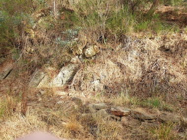
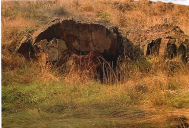
Photograph - Photograph - Colour, Anticline in the Hepburn Springs Reserve, 2019, 22/04/2019
... Anticline in the Hepburn Springs Reserve, 2019......anticline...Anticlines can exist as a single fold or as a series of adjacent folds of alternating synclines and anticlines. ...Colour photograph of an anticline at Hepburn Mineral Springs Reserve, in close proximity to the Sulphur Spring. ...Anticlines can exist as a single fold or as a series of adjacent folds of alternating synclines and anticlines. ...Anticlines are folded rock formations that have an upwards convex shape. Anticlines can exist as a single fold or as a series of adjacent folds of alternating synclines and anticlines. The Hepburn Springs anticline is geologically associated with the west dipping fissures cutting across sandstone strata of the Hepburn Spring anticline.Colour photograph of an anticline at Hepburn Mineral Springs Reserve, in close proximity to the Sulphur Spring. hepburn springs, anticline, geology, hepburn mineral springs reserve, hepburn anticline, hepburn geology -
 Bendigo Historical Society Inc.
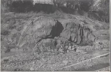
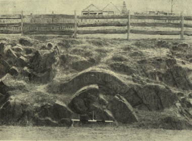
Photograph - Napoleon Anticline, 1935
... ...anticline...In structural geology, an anticline is a type of fold that is an arch-like shape and has its oldest beds at its core, whereas a syncline is the inverse of an anticline. ...Black and white photograph: rock formation, anticline with an archlike shape in centre of image. ...Written in pencil on back of photograph : 'Napoleon anticline Golden Square'....Photograph Napoleon Anticline ...In structural geology, an anticline is a type of fold that is an arch-like shape and has its oldest beds at its core, whereas a syncline is the inverse of an anticline. A typical anticline is convex up in which the hinge or crest is the location where the curvature is greatest, and the limbs are the sides of the fold that dip away from the hinge.Significant to mining history of Bendigo.Black and white photograph: rock formation, anticline with an archlike shape in centre of image. Written in pencil on back of photograph : 'Napoleon anticline Golden Square'.napoleon gold mine, anticline -
 Bendigo Historical Society Inc.
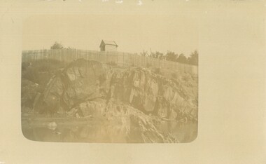
Photograph - POSTCARD - ANTICLINE ON BENDIGO CREEK
... ... anticline...Postcard: anticline on Bendigo Creek. Sepia print on postcard. ...History House 11 Mackenzie Street Bendigo goldfields PLACE Gold Bendigo anticline Bendigo creek Postcard: anticline on Bendigo Creek. ...Postcard: anticline on Bendigo Creek. Sepia print on postcard. Anticline in centre of photo. Paling fence extends along entire back of photo. Behind fence small weatherboard building (outhouse?) Written on back in pencil ' anticline in creek at Golden Square, area of old bridge over Bgo creek' Stamped in blue ' Bendigo Institute of Technology, Geology Dept. 'place, gold, bendigo, anticline, bendigo creek -
 Bendigo Historical Society Inc.
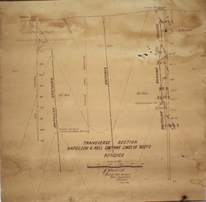
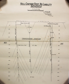
Plan - Napoleon, Nell Gwynne Transverse Section, 14.1.1946
... It embraces an approx length of 36 chains of the Napoleon Anticline. The old Napoleon shaft, the depth of which is 1020 ft, occupies a central position in the area of about 43 acres. ...Caldwell, District Field Geologist, Mines Department, Bendigo. 14.1.46'. Napoleon anticline and Central Nell Gwynne anticline marked on map. ...Caldwell, District Field Geologist, Mines Department, Bendigo. 14.1.46'. Napoleon anticline and Central Nell Gwynne anticline marked on map. ...Napoleon Lease no.11111 is situated immediately south from the Golden Square railway station. It embraces an approx length of 36 chains of the Napoleon Anticline. The old Napoleon shaft, the depth of which is 1020 ft, occupies a central position in the area of about 43 acres. The accompanying sections, which are prepared from mine Managers plans, illustrate the extent of previous underground operations and indicate points at which future prospecting may be advantageously continued. The no.10 (920 ft) south level connects with the main Napoleon shaft no.5 level (479 ft) appears to present the best opportunity for testing the prospects that are believed to have been inadequately investigated by the Bendigo Mines Limited in recent years.Map drawn on heavy paper. Printed on bottom of plan" Transverse Section Napoleon and Nell Gwynne Lines of Reef' and 'J.J. Caldwell, District Field Geologist, Mines Department, Bendigo. 14.1.46'. Napoleon anticline and Central Nell Gwynne anticline marked on map. Map is part of the Margaret Roberts Collection of mining documents. gold mining, bendigo, napoleon gold mine, nell gwynne, reef lines, j.j. caldwell, 1946 -
 Bendigo Historical Society Inc.
Photograph - ANTICLINE FOLD ROCK FORMATION - BENDIGO CREEK
... Colour photograph of an anticline fold rock formation - Bendigo Creek possibly in Golden Square. ...History House 11 Mackenzie Street Bendigo goldfields PHOTOGRAPH Landscape Anticline folds Colour photograph of an anticline fold rock formation - Bendigo Creek possibly in Golden Square. ...Colour photograph of an anticline fold rock formation - Bendigo Creek possibly in Golden Square. An anticline is a structural trap formed by the folding of rock strata into an arch-like shape. The rock layers in an anticlinal trap were originally laid down horizontally and then earth movement caused it to fold into an arch-like shape called an anticline.photograph, landscape, anticline folds -
 Ballarat Heritage Services
Photograph - Image, Anticlinal Fold, Lyttleton Street, Castlemaine, c1880, c1880
... An anticline at Castlemaine, Victoria. This natural feature was uncovered during Lyttleton Street roadworks in 1880. ...Saddle reefs occur in similar folds of the sandstones and slates on lower geological horizons." anticlinal fold geology castlemaine An anticline at Castlemaine, Victoria. This natural feature was uncovered during Lyttleton Street roadworks in 1880. ...In 1927 a plaque was installed at this anticlinal fold. Since no plaque is evident in the photo the date would be pre1927. The plaque states "This fine exhibit was disclosed when Lyttleton Street East was constructed in 1874. Saddle reefs occur in similar folds of the sandstones and slates on lower geological horizons." An anticline at Castlemaine, Victoria. This natural feature was uncovered during Lyttleton Street roadworks in 1880. anticlinal fold, geology, castlemaine -
 Bendigo Historical Society Inc.
Photograph - MCCOLL, RANKIN AND STANISTREET COLLECTION: ANTICLINE FOLD, 1930
... Black and white photo. Anticline folds from a road cutting in Studley Park, Melbourne.Snap by SEC 1930....Photograph MCCOLL, RANKIN AND STANISTREET COLLECTION: ANTICLINE FOLD ...Photograph. Black and white photo. Anticline folds from a road cutting in Studley Park, Melbourne.Snap by SEC 1930.photograph, landscape, anticline folds -
 Bendigo Historical Society Inc.
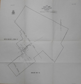
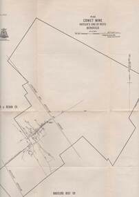
Map - COMET MINE - PLAN OF COMET MINE
... Map shows depths, Lightning Hill Anticline, Hustler's Anticline and approximate Lease Boundary. ...Map shows depths, Lightning Hill Anticline, Hustler's Anticline and approximate Lease Boundary. ...Plan of the Comet Mine on the Hustler's Line of Reefs Bulletin No 33, Plate No XXIII. Map shows depths, Lightning Hill Anticline, Hustler's Anticline and approximate Lease Boundary. Signed by H. S. Whitelaw, Underground Survey Office Bendigo, September 1913. United Hustler's & Redan Co and Hustler's Reef Co also named on map. Geological Survey of Victoriamining, hustler's line of reefs, comet line plan belletin no 33 plate no xxiii, lightning hill anticline, hustler's anticline, united hustler's & redan co, hustler's reef co, h s whitelaw -
 Bendigo Historical Society Inc.
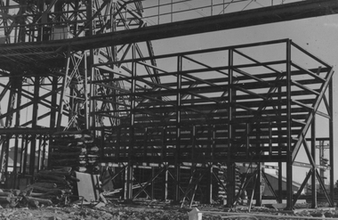
Photograph - Napoleon Ore Bins, 1935
... ...anticline...Napoleon Gold Mine anticline Written in pencil on back of photograph : 'Erecting ore bins at Napoleon 27/8/56' Black and white photograph: framework for ore bins at Napoleon (BML) Gold Mine, being erected alongside head frame at mine site. ...Significant to mining history of Bendigo.Black and white photograph: framework for ore bins at Napoleon (BML) Gold Mine, being erected alongside head frame at mine site. Trestle way visible in extreme top of image. Written in pencil on back of photograph : 'Erecting ore bins at Napoleon 27/8/56'napoleon gold mine, anticline -
 Bendigo Historical Society Inc.
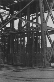
Photograph - Napoleon Ore Bins, 1935
... ...anticline...Napoleon Gold Mine anticline Written in pencil on back of photograph : 'Napoleon main shaft 2/9/35'' Black and white photograph: base of head frame with mine at top of shaft. ...Significant to mining history of Bendigo.Black and white photograph: base of head frame with mine at top of shaft. Rail trcks in foreground.Written in pencil on back of photograph : 'Napoleon main shaft 2/9/35''napoleon gold mine, anticline -
 Bendigo Historical Society Inc.
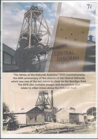
Photograph - CENTRAL DEBORAH GOLD MINE
... DVD Mine of the Deborah anticline. DVD commemorates the 60th anniversary of the closure of the Central Deborah, which was one of the last mines to close on the Bendigo field....Bendigo mines Central Deborah Mine DVD Mine of the Deborah anticline. DVD commemorates the 60th anniversary of the closure of the Central Deborah, which was one of the last mines to close on the Bendigo field. ...DVD Mine of the Deborah anticline. DVD commemorates the 60th anniversary of the closure of the Central Deborah, which was one of the last mines to close on the Bendigo field.bendigo mines, central deborah mine -
 Bendigo Historical Society Inc.
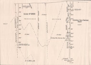
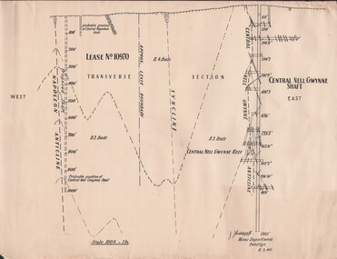
Plan - Mining Lease No. 10970, April, 2014
... One page plan of Lease No. 10970, showing Napoleon Anticline and Central Nell Gwynne Shaft. Prepared by J. ...goldmining quartz mining Central Nell Gwynne Gold Mine Napoleon Reef One page plan of Lease No. 10970, showing Napoleon Anticline and Central Nell Gwynne Shaft. Prepared by J. ...One page plan of Lease No. 10970, showing Napoleon Anticline and Central Nell Gwynne Shaft. Prepared by J. Caldwell, Mines Department Bendigo 6.2.1940.goldmining, quartz, mining, central nell gwynne gold mine, napoleon reef -
 Bendigo Historical Society Inc.
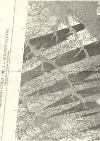
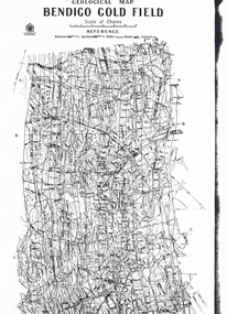
Map - GEOLOGICAL MAP BENDIGO GOLD FIELD
... Geological map Bendigo gold field. Showing anticlines, synclines, shafts, alluvial, contours. ...History House 11 Mackenzie Street Bendigo goldfields Geological map Bendigo gold field. Showing anticlines, synclines, shafts, alluvial, contours. ...Geological map Bendigo gold field. Showing anticlines, synclines, shafts, alluvial, contours. Produced by the deprtment of mines. Two originals plus two laminated copies -
 Bendigo Historical Society Inc.
Map - LONG GULLY HISTORY GROUP COLLECTION: BENDIGO GOLD FIELD - GOLDEN SQUARE GEOLOGICAL SURVEY OF VICTORIA
... Shown are reefs, faults and anticlines. Many of the mines are shown on the map. ...Shown are reefs, faults and anticlines. Many of the mines are shown on the map. ...BHS CollectionPart of a map of the Bendigo Gold Field - Golden Square. Geological Survey of Victoria. Shown are reefs, faults and anticlines. Many of the mines are shown on the map. Gullies, hills and streets are also shown.bendigo, history, long gully history group, the long gully history group - bendigo gold field - golden square geological survey of victoria, north bendigo state school reserve, hospital reserve, benevolent asylum reserve, empire hill, richmond hill, raes hill, south end hill, victoria hill, new chum hill, iron bark hill, redan hill, view hill, hustlers hill, camp hill -
 Bendigo Historical Society Inc.
Map - LONG GULLY HISTORY GROUP COLLECTION: GEOLOGICAL MAP - BENDIGO GOLD FIELD
... Map shows Lines of Reef, Anticlines, Synclines, Shafts, Alluvial Contours Gullies and some street names. ...Map shows Lines of Reef, Anticlines, Synclines, Shafts, Alluvial Contours Gullies and some street names. ...Copy of a Geological Map of the Bendigo Gold Field. Map shows Lines of Reef, Anticlines, Synclines, Shafts, Alluvial Contours Gullies and some street names. Copy is hard to read. There are two pages.bendigo, history, long gully history group, the long gully history group - geological map - bendigo gold field, mines department, h herman, lightning hill line, hustlers line, derby line, paddy's gully line, garden gully line, deborah line, sheepshead line, new chum line, nell gwynne line, british and foreign line, napoleon line, carshalton line, thistle line, christmas line, lancashire line -
 Bendigo Historical Society Inc.
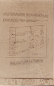
Document - CARSHALTON MINE - BLOCK DIAGRAM SHOWING THE PLAN OF DEVELOPMENT
... Beige sheet of paper of Block Diagram Showing the Plan of Development as Applied to Part of one Anticline. The diagram goes down for 20 levels. ...G.Consolidated Shaft Block Diagram Showing the Plan of Development as Applied to Part of One Anticline Beige sheet of paper of Block Diagram Showing the Plan of Development as Applied to Part of one Anticline. ...Beige sheet of paper of Block Diagram Showing the Plan of Development as Applied to Part of one Anticline. The diagram goes down for 20 levels. Also mentions the Napoleon Line and the G. G. Consolidated Shaft.place, mining site, carshalton mine, carshalton main shaft, napoleon line, g. g.consolidated shaft, block diagram showing the plan of development as applied to part of one anticline -
 Bendigo Historical Society Inc.
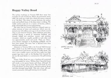
Document - LONG GULLY HISTORY GROUP COLLECTION: HAPPY VALLEY ROAD
... Describes surface workings on Victoria Hill and the different colours of the rocks, the formation of the anticlines and the synclines which are roughly parallel and run approximately north and south. ...Describes surface workings on Victoria Hill and the different colours of the rocks, the formation of the anticlines and the synclines which are roughly parallel and run approximately north and south. ...Titled Happy Valley Road. Describes surface workings on Victoria Hill and the different colours of the rocks, the formation of the anticlines and the synclines which are roughly parallel and run approximately north and south. They are all named and make the lines on the Bendigo Goldfield. Adjacent to Victoria Hill is the Central Nell Gwynne Mine which is on the Nell Gwynne anticline. There were quaint houses and shops in Happy Valley Road, although the shops are no longer used as such. On the right are two sketches, one an old house and below it is Heinz Butcher's Shop.bendigo, history, long gully history group, the long gully history group - happy valley road, victoria hill, central nell gwynne mine, bendigo city council, mr jack barker, william rae, heinz butcher's shop -
 Bendigo Historical Society Inc.
Plan - Nell Gwynne Reef
... Caidwell District Field Geologist, Mines Department BENDIGO 12. 10. 1940 Underneath there is a drawing labeled TRANVERSE SECTION showing East, Natural surface, Nell Gwynne Anticline, Railway Goldfields shaft, New Chum Syncline, New Chum Railway Shaft, New Chum Anticline, West Forms part of the Margaret Roberts Collection ...Caidwell District Field Geologist, Mines Department BENDIGO 12. 10. 1940 Underneath there is a drawing labeled TRANVERSE SECTION showing East, Natural surface, Nell Gwynne Anticline, Railway Goldfields shaft, New Chum Syncline, New Chum Railway Shaft, New Chum Anticline, West Forms part of the Margaret Roberts Collection Plan Nell Gwynne Reef ...Mr. J. J. Caldwell was appointed Officer in charge of the Bendigo Geological branch of the Victorian Mine s Department in 1923. He received his early training in the Castlemaine and Bendigo Schools of Mines and later at the Melbourne Technical College. He entered the Mines Department in 1900 as a junior chainman. Draftsman's drawing in black ink on off-white paper. Printed at the top NELL GWYNNE REEF . NO LIABILTY BENDIGO Scale of feet (100 feet to an inch) Singed J. Caidwell District Field Geologist, Mines Department BENDIGO 12. 10. 1940 Underneath there is a drawing labeled TRANVERSE SECTION showing East, Natural surface, Nell Gwynne Anticline, Railway Goldfields shaft, New Chum Syncline, New Chum Railway Shaft, New Chum Anticline, West Forms part of the Margaret Roberts Collection bendigo, margaret roberts, gold, map, mine, j. j. caldwell -
 Bendigo Historical Society Inc.
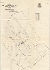
Map - GREAT EXTENDED HUSTLER'S MINE - PLAN OF THE GREAT EXTENDED HUSTLER'S MINE
... Mine was located in the block bounded by Langston and Anderson Streets and was between the Hustler's Anticline at Surface and the Lightning Hill Anticline at Surface. ...Mine was located in the block bounded by Langston and Anderson Streets and was between the Hustler's Anticline at Surface and the Lightning Hill Anticline at Surface. ...Plan of the Great Extended Hustler's Mine on the Hustler's Line of Reefs, Bendigo. Bulletin No 33, Plate No X. Lease No 7382. Plan has map of streets. Mine was located in the block bounded by Langston and Anderson Streets and was between the Hustler's Anticline at Surface and the Lightning Hill Anticline at Surface. Latham & Watson's Shaft is also mentioned. Levels are numbered and a table shows the Levels and their Depths. Geological Survey of Victoria. Signed by H A Whitelaw, Underground Survey Office, Bendigo, September 1913. This item has not been scanned or photographed.mining, parish map, great extended hustler's mine, hustler's line of reefs, mining lease no 7382, geological survey of victoria, underground survey office bendigo, h a whitelaw, latham & watson's shaft -
 Bendigo Historical Society Inc.
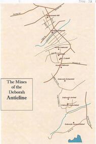
Document - THE MINES OF THE DEBORAH ANTICLINE
... Plan of the mines along the Deborah Anticline: Deborah Consolidated, Deborah Associated, Deborah United, Deborah Extended, South Deborah, No. 2 shaft, Deborah North Deborah, Central Deborah, Monument Hill are all sited on the plan....Document THE MINES OF THE DEBORAH ANTICLINE ...Plan of the mines along the Deborah Anticline: Deborah Consolidated, Deborah Associated, Deborah United, Deborah Extended, South Deborah, No. 2 shaft, Deborah North Deborah, Central Deborah, Monument Hill are all sited on the plan.Philip Wilkin, volunteer, BHSbendigo, mining, deborah line of reef -
Bendigo Historical Society Inc.
Map - GEOLOGICAL MAP OF BENDIGO GOLD FIELD
... Map of Bendigo gold field showing anticlines, synclines, shaft, alluvial deposits and contour lines. ...History House 11 Mackenzie Street Bendigo goldfields BENDIGO Gold mining geological map Geological Survey Victoria Map of Bendigo gold field showing anticlines, synclines, shaft, alluvial deposits and contour lines. ...Map of Bendigo gold field showing anticlines, synclines, shaft, alluvial deposits and contour lines. Map is in two sections. This map forms part of the Geological Survey of Victoria, Structure of Bendigo Goldfield report, No. 47, 1923. H.Herman, late Director of Geological Survey.Geological Survey Victoriabendigo, gold mining, geological map -
 Bendigo Historical Society Inc.
Map - STRUGNELL COLLECTION: HUSTLER'S LINE OF REEFS, BENDIGO
... XX111 (23).Lightning Hill Anticline at Surface, United Hustler's & Redan Co., Hustler's Reef Co. ...XX111 (23).Lightning Hill Anticline at Surface, United Hustler's & Redan Co., Hustler's Reef Co. ...Map, Hustler's Line of Reefs, Comet Mine, Plan, Plate No. XX111 (23).Lightning Hill Anticline at Surface, United Hustler's & Redan Co., Hustler's Reef Co. Bulletin No 33 Signed H.A. Whitelaw Underground survey Office Bendigo September 1913Underground Survey Office, Bendigo.bendigo mines, hustler's line of reef, comet mine -
 Federation University Historical Collection
Booklet, The New South Wales Educational Gazette, 01 February 1896, 01/02/1896
... ...anticline...Barker Library (top floor) Mount Helen goldfields molong anticline syncline jenolan Education Gazette educational gazette Booklet published for New South Wales teachers. ...Booklet published for New South Wales teachers. Articles include: * A Comparison of the Classical and Shakespean Dramas. * Geology for Australian Students by Rev. J. Miln Curran * From the Atlantic to the Pacific: Niagara to Minneapolis * G.A. Henty * The Study of Entomology by Walter W. Froggatt molong, anticline, syncline, jenolan, education gazette, educational gazette -
 Bendigo Historical Society Inc.
Document - MCCOLL, RANKIN AND STANISTREET COLLECTION: NAPOLEON REEF GOLD MINING CO. N.L, 1940
... Document: 4 copies of plan of Transverse Section of Napoleon Anticline Lease no 10970, plan shows proposed shaft location and depth (1000 ft), for Napoleon Reef Gold Mining Co, also location and depth of adjacent Central Nell Gwynne Shaft scale 100ft = 1 inch, Prepared by J.J. ...History House 11 Mackenzie Street Bendigo goldfields ORGANIZATION Business industrial - mining McColl Rankin & Stanistreet mining gold mining Napoleon Reef Document: 4 copies of plan of Transverse Section of Napoleon Anticline Lease no 10970, plan shows proposed shaft location and depth (1000 ft), for Napoleon Reef Gold Mining Co, also location and depth of adjacent Central Nell Gwynne Shaft scale 100ft = 1 inch, Prepared by J.J. ...Document: 4 copies of plan of Transverse Section of Napoleon Anticline Lease no 10970, plan shows proposed shaft location and depth (1000 ft), for Napoleon Reef Gold Mining Co, also location and depth of adjacent Central Nell Gwynne Shaft scale 100ft = 1 inch, Prepared by J.J. Caldwell Mines Dept Bendigo.organization, business, industrial - mining, mccoll rankin & stanistreet, mining, gold mining, napoleon reef -
Bendigo Historical Society Inc.
Map - BENDIGO GOLD FIELD GEOLOGICAL MAP, 1923
... Map in two sections, colour coded showing anticlines, synclines, shafts, fault lines, fossils. ...Map in two sections, colour coded showing anticlines, synclines, shafts, fault lines, fossils. ...Geological map of the Bendigo Gold Field showing stratigraphical zones. Map in two sections, colour coded showing anticlines, synclines, shafts, fault lines, fossils. Signed by H. Herman. This map forms part of the Geological Survey of Victoria, Structure of Bendigo Goldfield report, No. 47, 1923. H.Herman, late Director of Geological Survey.Geological Survey Victoriabendigo, gold mining, geological map -
Bendigo Historical Society Inc.
Map - BENDIGO GOLD FIELD GEOLOGICAL MAP
... Map in two sections, colour coded showing anticlines, synclines, shafts, fault lines, fossils. ...Map in two sections, colour coded showing anticlines, synclines, shafts, fault lines, fossils. ...Geological map of the Bendigo Gold Field showing stratigraphical zones. Map in two sections, colour coded showing anticlines, synclines, shafts, fault lines, fossils. Signed by H. Herman. This map forms part of the Geological Survey of Victoria, Structure of Bendigo Goldfield report, No. 47, 1923. H.Herman, late Director of Geological Survey.Geological Survey Victoriabendigo, gold mining, geological map -
 Bendigo Historical Society Inc.
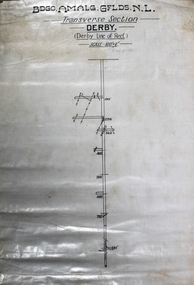
Map - Derby Line of Reef, Unknown
... Informit: Lease application no.11038 contains a length of about 48 chains of the Paddy's Gully line of reefs. The Derby Anticline penetrates the area from its north boundary for a distance ofabout 30 chains at which point the fold disappears southwards. ...Informit: Lease application no.11038 contains a length of about 48 chains of the Paddy's Gully line of reefs. The Derby Anticline penetrates the area from its north boundary for a distance ofabout 30 chains at which point the fold disappears southwards. ...Informit: Lease application no.11038 contains a length of about 48 chains of the Paddy's Gully line of reefs. The Derby Anticline penetrates the area from its north boundary for a distance ofabout 30 chains at which point the fold disappears southwards. The outcrop of the Paddy's Gully Anticline is exposed in McClure Street. Along this section of the Paddys Gully line the top of what is regarded as 'favorable beds' occurs about 150 feet from the surface. It is estimated that the containing beds of Ladam's reef and the Garden Gully 300 feet reef, both of which proved to have been rich ore bodies on the Garden Gully line adjoining on the west, will be found at the approximate depth of 550 feet onthe Paddy's Gully line near the intersection of McClure and Bannerman Streets. A shorter vertical point of attack, though the position is less favorable geologically, is kocks Pioneer east shaft which is 420 feet deep. A crosscut east from this shaft ata depth of 200 feet reaches the Derby Line in a distance of 700 feet. (https://search.informit.org/doi/10.3316/aesis.200104712) Printed in black text on top of plan: 'Bgo Amalg Gflds N.L." (Bendigo Amalgamated Goldfields N.L.) Transverse Section, Derby, Derby Line of Reef. Scale 100' = 1". Plan forms part of the Margaret Roberts Collection.gold mining, gold, bendigo, derby, derby line of reef, transverse section -
 Bendigo Historical Society Inc.
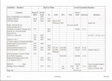
Document - GREAT EXTENDED HUSTLERS MINE - NOTES ON HUSTLERS ANTICLINE
... Two copies of two pages of hand written notes (one in blue pen and one in black pen) on the Hustlers Anticline. They are numbered Page 266 (Great Extended Hustlers) and Page 267 (Latham and Watsons). ...Document GREAT EXTENDED HUSTLERS MINE - NOTES ON HUSTLERS ANTICLINE ...Two copies of two pages of hand written notes (one in blue pen and one in black pen) on the Hustlers Anticline. They are numbered Page 266 (Great Extended Hustlers) and Page 267 (Latham and Watsons). Notes give name of company, depth of shaft, the years, Calls, Divs, Tons, Ozs of Gold, Authority and Remarks. Black copy has: Copied 25-10-68 written on it.mine, gold, great extended hustlers., great extended hustlers mine, hustlers anticline, hustlers hill co., tuff & joseph, rigby peterson & co, james kershaw & co, garibaldi co, messrs finnigan & co, scott & smith, stewart & co, ulster coy main no 1& no 2, south hustlers great extd co, londonderry co, great extended hustlers, great extended hustlers trib no 1, g. b. both co, great extended hustlers maria trib, j b hustlers trib co, bendigo amal goldfields, jonathan harris claim (hustlers or mac's hill), latham watson & hustlers, latham watson & sibley (sibley & co), latham & watson, latham & watson's nos 1 & 2 tribs, great hustlers co, great extended hustlers reef g m no 1, koh-i-noon co -
 Bendigo Historical Society Inc.
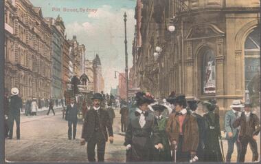
Postcard - Elliot Postcard Collection: Australia, 1895 - 1914
... W. 1405.225 Part of the Cutting, Barren Jack 1405.226 "Genoa", Musgrave St, Mosman 1405.227 How We Beat The Favourite 1405.228 Anticline, Taemas near Yass...W. 1405.225 Part of the Cutting, Barren Jack 1405.226 "Genoa", Musgrave St, Mosman 1405.227 How We Beat The Favourite 1405.228 Anticline, Taemas near Yass Postcard Elliot Postcard Collection: Australia ...Thought to have originated in Austria in 1869, postcards first gained popularity in Australia in the 1890s.They were used to send short messages to friends and family. This collection was generated by Mary Emma Elliot of Talgarno. Talgarno is a rural locality in Victoria, Australia, situated on the southern shoreline of Lake Hume, about 23 km east of Albury-Wodonga. The collection contains postcards from across the world. Mary Emma Sibley was born in Ironbark, Bendigo in 1859. She married James Elliot in 1893 and they settled at “Kelso”, Talgarno. They had two children – Mona and Sibley. Mary Emma Elliot died in Melbourne in 1944, aged 84 years. Australian postcards collected by Mrs. James Elliot between 1898 and 1915. 1405.221 Pitt St, Sydney 1405.222 Town Hall, Sydney 1405.223 Elizabeth St, Sydney 1405.224 Newcastle Hospital, N. S. W. 1405.225 Part of the Cutting, Barren Jack 1405.226 "Genoa", Musgrave St, Mosman 1405.227 How We Beat The Favourite 1405.228 Anticline, Taemas near Yasspostcards, collecting, collections, talgarno -
 Bendigo Historical Society Inc.
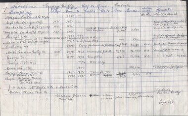
Document - CARLISLE MINE - GOLD PRODUCTION
... 2 hand written sheets of paper, titled Anticline Garden Gully - Reef or Mine Carlisle. ...Bendigo 2 hand written sheets of paper, titled Anticline Garden Gully - Reef or Mine Carlisle. ...2 hand written sheets of paper, titled Anticline Garden Gully - Reef or Mine Carlisle. Has the name of companies, depth of shaft, years, calls, Divs, Tons, Ounces, Authority & Remarks. Dates from 1860 to 1918. Reference: Production Statistics Bendigo Mines N. L. Bendigo Goldfields, History & Production. General Index. Companies & Reefs. Pages 196 & 197. Mines Dept. Bendigo Office.mine, gold, carlisle, carlisle mine, gold production, mines dept. bendigo