Showing 262 items matching " city boundary"
-
 Federation University Historical Collection
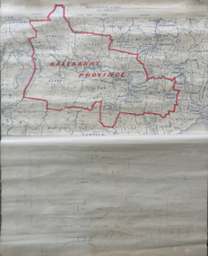
Map, Ballarat Municipalities and City Boundary
... Ballarat Municipalities and City Boundary....Bottom half is drawn directly onto linen and depicts Ballaarat City Boundary including street names. 'Scale about 20 chains to 1 inch'....Ballarat Municipalities and City Boundary. Map Map ...Piece of linen attached at top and bottom with wooden rails. Top half of linen has a paper map of Ballaarat Province and Surrounding Municipalities directly attached to it and reads 'Ballaarat Province' in red ink which outlines the greater Ballarat area with surrounding municipalities shown in blue. Scale is '8 miles to 1 inch'. Bottom half is drawn directly onto linen and depicts Ballaarat City Boundary including street names. 'Scale about 20 chains to 1 inch'.ballarat electorate, map, ballaarat province, ballarat to buninyong railway -
 Bendigo Historical Society Inc.
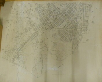
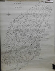
Map - BENDIGO SHEET 2
... ... City boundary...Parish map showing the southern section of the City of Bendigo. It shows the city boundary running along Murphy Street, Grave (Patterson) Street, and the turns at the south end of Macdougall Road, the corner of Alder and Aspinal Streets and the corner near the Specimen Hill - Marong roads intersection...History House 11 Mackenzie Street Bendigo goldfields MAP Bendigo city streets Parish Map City boundary H.J. Green Govt. Printer, Melbourne Parish map showing the southern section of the City of Bendigo. ...Parish map showing the southern section of the City of Bendigo. It shows the city boundary running along Murphy Street, Grave (Patterson) Street, and the turns at the south end of Macdougall Road, the corner of Alder and Aspinal Streets and the corner near the Specimen Hill - Marong roads intersectionH.J. Green Govt. Printer, Melbournemap, bendigo, city streets, parish map, city boundary -
 Port Melbourne Historical & Preservation Society
Document - Electoral Roll, City of Port Melbourne, Boundary Ward, City of Port Melbourne, Voters' Rolls, 1983
... Electoral Roll, City of Port Melbourne, Boundary Ward...Voters Roll for City of Port Melbourne's Boundary Ward: list of electors entitled to be enrolled on Municipal Clerk's rolls....Voters' Rolls Document Electoral Roll, City of Port Melbourne, Boundary Ward City of Port Melbourne ...Prepared by the Town clerk's office. Voters Roll for City of Port Melbourne's Boundary Ward: list of electors entitled to be enrolled on Municipal Clerk's rolls.Voters' Rolls 1983/84 City of Port Melbourne, Electoral Province of Melbourne, Port Melbourne Division Sandridge Ward - List of electors entitled to be enrolled on Municipal Clerks' Rolls @ 29 July 1983.local government - city of port melbourne, town clerks, frederick charles jackson -
 Sunshine and District Historical Society Incorporated
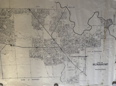
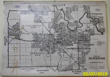
Map - City of Sunshine Boundaries 1994 Maps
... 4 maps (wall) depicting the City of Sunshine Boundaries...City of Sunshine Boundaries 1991 wall maps...City of Sunshine City of Sunshine Boundaries 1991 wall maps 4 maps (wall) depicting the City of Sunshine Boundaries Map City of Sunshine Boundaries 1994 Maps ...City of Sunshine Boundaries 1991 wall mapscity of sunshine -
Port Melbourne Historical & Preservation Society
Document - Electoral Roll, City of Port Melbourne, City of Port Melbourne, Voters Roll, City of Port Melbourne - Boundary Ward, Jul 1990
... Voters Roll, City of Port Melbourne - Boundary Ward...Voters roll, City of Port Melbourne 1990: List in alphabetical order of residents in Boundary Ward. ...Graham, Municipal Clerk, is on back page Voters Roll, City of Port Melbourne - Boundary Ward Document Electoral Roll, City of Port Melbourne City of Port Melbourne ...Prepared by the Town Clerk's office. Voters roll, City of Port Melbourne 1990: List in alphabetical order of residents in Boundary Ward. Signature of A.D. Graham, Municipal Clerk, is on back pagelocal government - city of port melbourne, town clerks, david graham -
 Bendigo Historical Society Inc.
Document - PETER ELLIS COLLECTION: LETTER, 4th October, 1976
... ... City Boundary Stone...COMMUNICATION Postal letters Peter Ellis Collection The Bendigo Field Naturalists Club Proposed Boyd St Nature Reserve The Hon W A Borthwick Recreation Reserve Extension (Rs 3458) Cemetry Reserve Extension (Rs 3777) Rubbish Depot (Rs 5980) Education Purposes Reserve J Willis Bendigo City Council City Boundary Stone Quarry Hill Golf Club Canberra Botanical Gardens Stony Ridge Flora Reserve Sydney Kings Park Perth Maranoa Gardens Melbourne Kaweka Sanctuary Castlemaine Central and Northern Branch of the National Trust School Sanctuary (Quarry hill) Education Dept Society for Growing Australian Plants - Bendigo Group Lawn Cemetery Bendigo City Council Parks and Recreation Dept Bendigo Trust Afforestation Committee Quality of Life Action Group Ackhurst Plan Winifred Waddell Estate Dept of Crown Lands and Survey Ministry for Conservation Mr G Edwards Mr M Goode Mr J Chellacombe Diana R Collier Letter, dated 4/10/1976 from Diana R. ...Letter, dated 4/10/1976 from Diana R. Collier, Hon. Secretary, The Bendigo Field Naturalists Club to The Minister for Lands, The Hon. W. A. Borthwick making an application to have a reserved area for the preservation of native flora and fauna near the Quarry Hill Golf Club. Features, fauna and flora are mentioned including an original Boundary Stone and the Fairy Waxflower (Eriostemon verrucosus) also known as the Bendigo Wax Flower. Included is a list of birds (including some that nest in the area sometimes) and plants.communication, postal, letters, peter ellis collection, the bendigo field naturalists club, proposed boyd st nature reserve, the hon w a borthwick, recreation reserve extension (rs 3458), cemetry reserve extension (rs 3777), rubbish depot (rs 5980), education purposes reserve, j willis, bendigo city council, city boundary stone, quarry hill golf club, canberra botanical gardens, stony ridge flora reserve sydney, kings park perth, maranoa gardens melbourne, kaweka sanctuary castlemaine, central and northern branch of the national trust, school sanctuary (quarry hill), education dept, society for growing australian plants - bendigo group, lawn cemetery, bendigo city council parks and recreation dept, bendigo trust afforestation committee, quality of life action group, ackhurst plan, winifred waddell estate, dept of crown lands and survey, ministry for conservation, mr g edwards, mr m goode, mr j chellacombe, diana r collier -
 Bendigo Historical Society Inc.
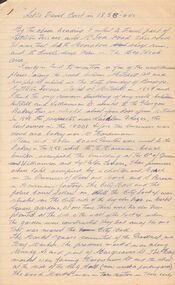
Document - LET'S TRAVEL EAST IN 1858 - 60'S
... Nine pages of handwritten account of businesses from Mitchell Street, along Lyttleton Terrace and McIvor Road to the City boundary on the Bendigo side of Murphy Street....dea Mr Worth Mr Condon Mr C Cahill Nolan Family Mr Sides The Nailons Mrs Boyan Jacky Bryant John Oconnell General Store Mr Pierce Mr Matthews Mr Neil Ward Mr Hagan William Clapton Mr Joseph Dowd Mr Morris Ancient Briton Hotel The Woolpak The Railway Bridge Ampol Service Station Farrells Dairy Farringtons Brickworks Jacksons Hide & Tallow Yard Fergusons Royal Oak Hotel Mr Jackson Mr Knight St Marys Common School No812 Mrs Rersol W D Quinn Mr March Mr Fred Randall Mr Steeple The Limerick Hotel Back Creek Police Shooting Range Police Station Stone Lockup Holts Service Station Steepe's Butcher Shop Joch John Hattam Nine pages of handwritten account of businesses from Mitchell Street, along Lyttleton Terrace and McIvor Road to the City boundary on the Bendigo side of Murphy Street. ...Nine pages of handwritten account of businesses from Mitchell Street, along Lyttleton Terrace and McIvor Road to the City boundary on the Bendigo side of Murphy Street.document, let's travel east in 1858 - 60's, moorabbee sheep run, curr's sheep run, glasgow bakery, lachlan frazer, mr hardiman, steen and holm coach painters, mr h haisman coach builder, scholton and march, march and s brown, haisman factory, city hall, police court, city lockup, market square, senior citizens club, weighbridge, dunlop tyre service station, tommy burns, matt lynch, tom & mick kennedy, darling hotel, the innes, mr bullens fruit shop, bricklayers arms hotel, cheshire arms hotel, mr i boffey, newcombe's timber yard, quinns monumental establishment, alexandra fountain, cumberland hotel, sannaman's coach factory, town hall hotel, her majesties open air picture show, mr r anderson, john ohagan, sandhurst hotel, the melbourne café, haymarket hotel, the old haymarket hotel, the market ale house, the prince of wales theatre, manchester hotel, mr john doran, dr backhaus, manchester hall, the bendigo star, james griffen coach factory, mr george lansell, whitting's marine store, cartrights marine store, sandhurst flour mills, mr john buckley, moorhead hay and corn mills, brian boru hotel, mr m r?dea, mr worth, mr condon, mr c cahill, nolan family, mr sides, the nailons, mrs boyan, jacky bryant, john oconnell general store, mr pierce, mr matthews, mr neil ward, mr hagan, william clapton, mr joseph dowd, mr morris, ancient briton hotel, the woolpak, the railway bridge, ampol service station, farrells dairy, farringtons brickworks, jacksons hide & tallow yard, fergusons, royal oak hotel, mr jackson, mr knight, st marys common school no812, mrs rersol, w d quinn, mr march, mr fred randall, mr steeple, the limerick hotel, back creek police shooting range, police station, stone lockup, holts service station, steepe's butcher shop, joch, john hattam -
 Sunshine and District Historical Society Incorporated
Map - City of Sunshine Map
... Map showing the City of Sunshine boundary and streets...City of Sunshine Map City of Sunshine Map Map showing the City of Sunshine boundary and streets Map City of Sunshine Map ...City of Sunshine Mapcity of sunshine, map -
 Sunshine and District Historical Society Incorporated
Map - City of Sunshine Map June 1971
... Large map of City of Sunshine showing streets names, location of libraries, elderly citizen centres, kindergartens, infant welfare centres, police stations, court houses, fire brigade stations, railway lines, railway stations, quarries, city boundary lines & parish boundary lines...Part of the Gwen Goedecke Collection City of Sunshine City of Sunshine Map June 1971 Large map of City of Sunshine showing streets names, location of libraries, elderly citizen centres, kindergartens, infant welfare centres, police stations, court houses, fire brigade stations, railway lines, railway stations, quarries, city boundary lines & parish boundary lines Map City of Sunshine Map June 1971 ...Part of the Gwen Goedecke CollectionCity of Sunshine Map June 1971city of sunshine -
 Bendigo Historical Society Inc.
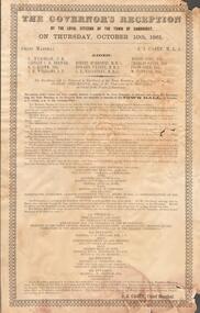
Document - GOVERNOR'S RECEPTION 1861
... The program for the day is detailed, with instructions as to the order that participants should muster before the greeting of the Governor at the City Boundary at Kangaroo Flat. 'His Excellency will be welcomed to Sandhurst at the Town Boundary at Two o'clock p.m by Robert Strickland Esq. ...The program for the day is detailed, with instructions as to the order that participants should muster before the greeting of the Governor at the City Boundary at Kangaroo Flat. 'His Excellency will be welcomed to Sandhurst at the Town Boundary at Two o'clock p.m by Robert Strickland Esq. ...Victorian Governor, Sir Henry Barkly visited Bendigo in Oct. 1861 as part of his regional tour that included, Castlemaine, Chewton, Back Creek and Inglewood.Buff coloured document. Written on top 'The Governor's Reception by the Loyal Citizens of the Town of Sandhurst on Thursday October 10th 1861. The program for the day is detailed, with instructions as to the order that participants should muster before the greeting of the Governor at the City Boundary at Kangaroo Flat. 'His Excellency will be welcomed to Sandhurst at the Town Boundary at Two o'clock p.m by Robert Strickland Esq. J.P. Chairman of the Municipality on behalf of the People of Sandhurst'bendigo, council, governor's reception 1861 -
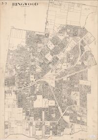 Ringwood and District Historical Society
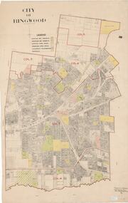
Map, City of Ringwood - Rateable Properties Layout - c.1966
... A0-size (approx) map of named streets, lot-numbered properties and locality features within City of Ringwood boundary. ...City Engineer's signature in bottom right corner - Alan Robertson (City Engineer 1958-1987) A0-size (approx) map of named streets, lot-numbered properties and locality features within City of Ringwood boundary. City of Ringwood - Rateable Properties Layout - c.1966 Map ...A0-size (approx) map of named streets, lot-numbered properties and locality features within City of Ringwood boundary. Scale: 8 chains to 1 inch. City Engineer's signature in bottom right corner - Alan Robertson (City Engineer 1958-1987) -
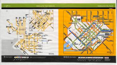 Melbourne Tram Museum
Poster, Yarra Trams, "Melbourne Tram Network", Nov. 2005
... Shows a diagrammatic layout of the Melbourne tram system, shows zones (2 zones), CBD, tram terminuses including the City Saver boundary. Has the Yarra Trams and Metlink logos. ...Shows a diagrammatic layout of the Melbourne tram system, shows zones (2 zones), CBD, tram terminuses including the City Saver boundary. Has the Yarra Trams and Metlink logos. ...Full colour poster printed, A3 size, on laminated sheet - titled "Melbourne Tram Network. Shows a diagrammatic layout of the Melbourne tram system, shows zones (2 zones), CBD, tram terminuses including the City Saver boundary. Has the Yarra Trams and Metlink logos. Dated Effective November 2005trams, tramways, yarra trams, metlink, maps, metcard, tickets, city section -
 Bendigo Historical Society Inc.
Document - CITY OF BENDIGO WARD BOUNDARIES
... One page typewritten document titled City of Bendigo Ward Boundaries. The document details the boundaries of the Sutton, Darling and Barkly wards....Document CITY OF BENDIGO WARD BOUNDARIES ...One page typewritten document titled City of Bendigo Ward Boundaries. The document details the boundaries of the Sutton, Darling and Barkly wards.government, local, city of bendigo -
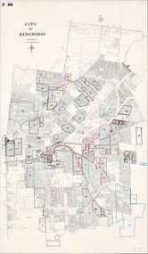 Ringwood and District Historical Society
Map, City of Ringwood - Rateable Properties Layout - c.1966
... A0-size (approx) map of named streets, lot-numbered properties and locality features within City of Ringwood boundary. Coloured outlines of subsequent subdivisions. ...A0-size (approx) map of named streets, lot-numbered properties and locality features within City of Ringwood boundary. Coloured outlines of subsequent subdivisions. ...A0-size (approx) map of named streets, lot-numbered properties and locality features within City of Ringwood boundary. Coloured outlines of subsequent subdivisions. Seperate enlargement showing northern half of map.Scale: 8 chains to 1 inch. -
 Sunshine and District Historical Society Incorporated
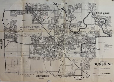
Map - CITY OF SUNSHINE MAP June 1967, 1967
... The June 1967 map is of the previous CITY OF SUNSHINE showing City and Parish boundaries, streets, railways, creeks, river etc....The June 1967 map is of the previous CITY OF SUNSHINE showing City and Parish boundaries, streets, railways, creeks, river etc. ...The City of Sunshine no longer exists. Part of the eastern area has been annexed by the City of Maribyrnong, and the rest of the old City of Sunshine has been amalgamated with the City of Keilor to form the larger City of Brimbank.This 1967 map is a historical record of the City of Sunshine as it existed 27 years before the amalgamation of Councils, and the creation of the City of Brimbank in 1994.Whitish paper map with black printing that is laminated in clear plastic film, and has a wood slat attached to the top edge. The June 1967 map is of the previous CITY OF SUNSHINE showing City and Parish boundaries, streets, railways, creeks, river etc.Purple ink stamps at top left hand and right hand areas showing address and contact details of 'Sunshine Industrial Promotion Centre.'city of sunshine, june 1967, map, city, parish, boundaries, brimbank -
 Ringwood and District Historical Society
Map, City of Ringwood - Rateable Properties Layout - c.1966. Overlay showing Reserves, Open Space, Playgrounds, and Schools
... A0-size (approx) map of named streets, lot-numbered properties and locality features within City of Ringwood boundary. Colour-coded legend identifying Existing Rec Reserves, Proposed Rec Reserves, Existing Open Space, Children's Playgrounds, and Schools....A0-size (approx) map of named streets, lot-numbered properties and locality features within City of Ringwood boundary. Colour-coded legend identifying Existing Rec Reserves, Proposed Rec Reserves, Existing Open Space, Children's Playgrounds, and Schools. ...A0-size (approx) map of named streets, lot-numbered properties and locality features within City of Ringwood boundary. Colour-coded legend identifying Existing Rec Reserves, Proposed Rec Reserves, Existing Open Space, Children's Playgrounds, and Schools.Scale: 8 chains to 1 inch. Map picked up in Engineer's office at old town hall prior to demolition 1971. -
 Bendigo Historical Society Inc.
Map - JACK FLYNN COLLECTION: BENDIGO, Revised 1/01/1961
... Showing the city within the Municipal Boundaries, also has contour lines and the Major Gullies. ...Showing the city within the Municipal Boundaries, also has contour lines and the Major Gullies. ...Map: Bendigo city, it has City of Bendigo Planning Scheme as the title. Showing the city within the Municipal Boundaries, also has contour lines and the Major Gullies. Revised 1.1.1962.map, bendigo, city streets, bendigo planning scheme -
Port Melbourne Historical & Preservation Society
Flyer, City of Port Melbourne, Vintage Port Worth Preserving, 13 Oct 1993
... Notice is for a public meeting about the new City of Melbourne boundaries which impact on Port Melbourne. ...Notice is for a public meeting about the new City of Melbourne boundaries which impact on Port Melbourne. ..."Vintage Port Worth Preserving" Blue flyer with black print. City of Port Melbourne logo at top. Notice is for a public meeting about the new City of Melbourne boundaries which impact on Port Melbourne. "Cr, Liana THOMPSON, Mayor" at bottom right cornerlocal government - city of port melbourne, port melbourne town hall, liana thompson, mayors, roger hallam, jeff kennett, amalgamation -
 Whitehorse Historical Society Inc.
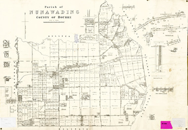
Legal record - Map, Parish of Nunawading, c1930
... Office of Lands and survey map, 1864 with many further subdivisions of 1870 onwards added. Boundaries of City of Box Hill included. Note added re Slater's land in Blackburn North....Whitehorse Historical Society Inc. 2-10 Deep Creek Road Mitcham melbourne maps shire of blackburn and mitcham city of box hill slater family Office of Lands and survey map, 1864 with many further subdivisions of 1870 onwards added. Office of Lands and survey map, 1864 with many further subdivisions of 1870 onwards added. Boundaries ...Office of Lands and survey map, 1864 with many further subdivisions of 1870 onwards added.Office of Lands and survey map, 1864 with many further subdivisions of 1870 onwards added. Boundaries of City of Box Hill included. Note added re Slater's land in Blackburn North. Office of Lands and survey map, 1864 with many further subdivisions of 1870 onwards added. maps, shire of blackburn and mitcham, city of box hill, slater family -
 Sunshine and District Historical Society Incorporated
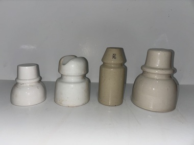
Functional object - Insulators
... Electrical porclain insulators were made by Sunshine Potteries & Maribyrnong Potteries, both companies located within the City of Sunshine Municipal Boundary...Electrical porclain insulators were made by Sunshine Potteries & Maribyrnong Potteries, both companies located within the City of Sunshine Municipal Boundary Sunshine Potteries Pottery Potteries Derby Road Sunshine Insulator Collection of 4 porcelain insulators Functional object Insulators ...Electrical porclain insulators were made by Sunshine Potteries & Maribyrnong Potteries, both companies located within the City of Sunshine Municipal BoundaryCollection of 4 porcelain insulatorssunshine potteries, pottery, potteries, derby road, sunshine, insulator -
 Greensborough Historical Society
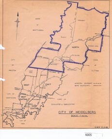
Map, City of Heidelberg, City of Heidelberg, 1962, 02/02/1962
... Map of City of Heidelberg showing boundaries of its six wards; North Ward is highlighted, covering Watsonia, Greensborough, part Bundoora, St Helena, Plenty, Yarrambat and Diamond Creek....Greensborough Historical Society 34A Glenauburn Road Lower Plenty Lower Plenty melbourne Map of City of Heidelberg showing boundaries of its six wards; North Ward is highlighted, covering Watsonia, Greensborough, part Bundoora, St Helena, Plenty, Yarrambat and Diamond Creek. city of heidelberg heidelberg - maps City of Heidelberg Scale: 1" to 1 ml. ...Map of City of Heidelberg showing boundaries of its six wards; North Ward is highlighted, covering Watsonia, Greensborough, part Bundoora, St Helena, Plenty, Yarrambat and Diamond Creek.Blue print mapCity of Heidelberg Scale: 1" to 1 ml. G.M.H. 2.2.62city of heidelberg, heidelberg - maps -
Port Melbourne Historical & Preservation Society
Document - Voter Rolls, City of Port Melbourne, Port Melbourne City Council, 1940s - 1970s
... Seven Voter lists, City of Port Melbourne. Boundary Ward, 1951. Centre ward 1951. ...Port Melbourne Historical & Preservation Society Port Melbourne Town Hall 333 Bay Street Port Melbourne melbourne Local Government - City of Port Melbourne Seven Voter lists, City of Port Melbourne. Boundary Ward, 1951. Centre ward 1951. ...Seven Voter lists, City of Port Melbourne. Boundary Ward, 1951. Centre ward 1951. Centre ward 1975. Sandridge ward 1963. Boundary Ward 1963. Sandridge ward 1963. All wards late 1940s to early 1950slocal government - city of port melbourne -
 Ringwood and District Historical Society
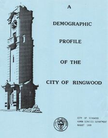
Document, City of Ringwood, Demographic profile of the City of Ringwood August 1989
... Civic Centre - New Telephone Numbers; 5. City of Ringwood - Boundary Map; 6. City of Ringwood - 3 folders (2 coloured) 1960 +Additional Keywords: de Giorgio, Miranda...Civic Centre - New Telephone Numbers; 5. City of Ringwood - Boundary Map; 6. City of Ringwood - 3 folders (2 coloured) 1960 +Additional Keywords: de Giorgio, Miranda Demographic profile of the City of Ringwood August 1989. ...During refurbishment of office in Civic Centre sent to VRDHS by Miranda de Giorgio, Community Liaison Officer 8-Dec-1993.Collection of documents about the City of Ringwood - civic centre.; 1. Demographic profile of the City of Ringwood August 1989.; 2. City of Ringwood - An Information Guide for Students- Nov 1991.; 3. Councillors names and addresses 5-Aug-1991; 4. Civic Centre - New Telephone Numbers; 5. City of Ringwood - Boundary Map; 6. City of Ringwood - 3 folders (2 coloured) 1960 +Additional Keywords: de Giorgio, Miranda -
 Dandenong & District Historical Society
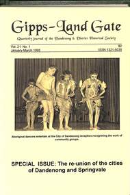
Journal, Dandenong & District Historical Society, Gipps-Land Gate Vol.21 No.1, 1995
... Special Issue: The Re-Union Of The Cities Of Dandenong And Springvale How the City Of Dandenong Became The City Of Greater Dandenong Dave Mickle Named As Dandenong Citizen Of The Year 1995 A City Says "Thank You" Toward Our New City Our Changing Boundaries Our Changing City Our First Corporate Members! ...Special Issue: The Re-Union Of The Cities Of Dandenong And Springvale How the City Of Dandenong Became The City Of Greater Dandenong Dave Mickle Named As Dandenong Citizen Of The Year 1995 A City Says "Thank You" Toward Our New City Our Changing Boundaries Our Changing City Our First Corporate Members! ...An interesting group of Early Dandenong Personalities, Places and EventsA5 size publication of the Gipps-Land Gate, January-March 1995 featuring an old picture of Dandenong on the cover. Special Issue: The Re-Union Of The Cities Of Dandenong And Springvale How the City Of Dandenong Became The City Of Greater Dandenong Dave Mickle Named As Dandenong Citizen Of The Year 1995 A City Says "Thank You" Toward Our New City Our Changing Boundaries Our Changing City Our First Corporate Members! An interesting group of Early Dandenong Personalities, Places and Eventshotel history, early education in dandenong, interesting milestones, family histories -
 Ballarat Tramway Museum
Slide - 35mm slide/s - set of 20, Noel Simons, 21/05/1971 12:00:00 AM
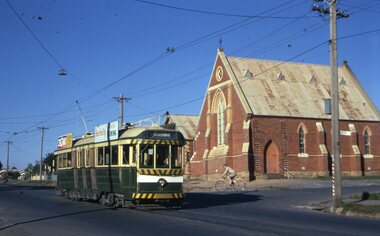
... On left hand side is the City of Bendigo sign, indicating city boundary. 1197.3 - As for 1197.2 but actually entering loop. ...On left hand side is the City of Bendigo sign, indicating city boundary. 1197.3 - As for 1197.2 but actually entering loop. ...Set of 20 transparencies taken on 21/5/1971 on Kodak mounts. 1197.1 - Bendigo No. 5 en route to Eaglehawk at Creeth St Long Gully. Tram has a SEC roof ad and Cinzano roof ad. 1197.2 - No 5 approaching Needle Loop between Long Gully and California Gully. On left hand side is the City of Bendigo sign, indicating city boundary. 1197.3 - As for 1197.2 but actually entering loop. Photo taken after tram has passed photographer. 1197.4 - No. 26 bound for Eaglehawk descending the railway bridge near Eaglehawk, at Jobs Gully. 1197.5 - as for 1197.4, but after crossing bridge, now ascending a hill. Photo taken after tram has passed photographer. 1197.6 - No. 26 climbing High St. hill Eaglehawk, nearing end of Double track, bound for Quarry Hill. Shows centre of the road poles. 1197.7 - As for 1197.6, with tram entering single track section. Photo taken after tram has passed photographer. Has a BP service station in the background. 1197.8 - No. 26 (bound for Quarry Hill) crossing No. 17 (Eaglehawk) at Job's Gully Loop. 1197.9 - No. 17 climbing railway bridge at Job's Gully, en route to Eaglehawk. Photo taken after tram has passed photographer. 1197.10 - No.26 bound for Quarry Hill, leaving Long Gully Loop? Has the Creeth St. church in l197.l in the far background. Photo taken after tram has passed photographer. 1197.11 - Tramway Point work at the northern end of Long Gully Loop. 1197.12 - No. 17 en route for Quarry Hill turning into View St. from Bamard St. Tram has SEC roof ads "Everything fine in my all electric Kitchen' and 'Electric Cooking is Matchless'. 1197.13 - as for 1197.12, but tram has turned into View St and about to enter the double line track. Photo taken after tram has passed photographer. 1197.14 - No. 21 enters Nolan St after turning from MacRae St. en route to Bendigo. Note sign on its own post noting tram turns "Beware Tram Turns" and stop sign on adjacent pole "Trams stop on Request". No. 21 has two SEC roof ads. 1197.15 - No. 21 in Nolan St. after turning from Bridge St. (White Hills Road). Note signal light for Bridge St. loop on pole corner of street. Photo taken after tram has passed photographer. 1197.16 - No. 2 bound for Eaglehawk at unknown location. 1197.17 - Tram stop sign on a pole "CARS STOP BY REQUEST" 1197.18 - No. 5 in Carpenter St.? en route to Quarry Hill. 1197.19 - No. 28 has just arrive at Golden Square terminus, passengers are disembarking and the trolley pole is being turned. Golden Square Hotel in the background. 1197.20 - No. 28 at Golden Square terminus. Has a "Nothing beats Briquettes for hear roof ad. Information written on in black ink and date stamped on purple ink. 1197.1 - "No. 5 at Creeth St. Long Gully" 1197.2 - "No. 5 approaching Needle Loop between Long Gully and California Gully" 1197.3 - "No. 5 at Needle Loop between Long Gully and California Gully" 1197.4 - "No. 26 crossing railway bridge at Job's Gully near Eaglehawk" 1197.5 - "No. 26 just after crossing railway bridge at Job's Gully near Eaglehawk/ 1197.6 - "No. 26 in High St. Eaglehawk" 1197.7 - "No. 26 at end of double track in High St. Eaglehawk" 1197.8 - "Nos. 26 and 17 crossing at Job's Gully Loop" 1197.9 - "No. 17 crossing railway bridge at Job's Gully near Eaglehawk". 1197.10 - "No. 26 at Long Gully" 1197.11 - 'Northern end of points at Long Gully Loop". 1197.12 - "No. 17 turning into View St. from Bamard St. Bendigo". 1197.13 -'No. 17 at beginning of double track in View St. after leaving Bamard St. Bendigo. 1197.14 - "No. 21 enters Nolan St. from MacRae St. Bendigo." 1197.15 - "No. 21 in Nolan St. Bendigo just after leaving White Hills Road." 1197.16 - "No. 2" 1197.18 - "No. 5" 1197.19 - "Birney car No. 28 at Golden Square Terminus" 1197.20 "Birney car No. 28 at Golden Square Terminus" tramways, trams, bendigo, long gully, railway bridge, jobs gully, trackwork, nolan st, quarry hill, tram stops, golden square, tram 2, tram 5, tram 17, tram 21, tram 26, tram 28 -
Glen Eira Historical Society
Document - History of the City of Caulfield
... This document also includes a map/diagram of the city with boundaries and wards showing locations of railway stations and parks. ...This document also includes a map/diagram of the city with boundaries and wards showing locations of railway stations and parks. ...This file contains 4 items: 1/Typewritten document titled ‘The City of Caulfield’. Author and date unknown. 1 page (back and front), 2 copies. Document covers topics such as origins of the name ‘Caulfield’, early settlement and the Caulfield Cup. 2/Typewritten document titled ‘History of Caulfield Council’. Author and date unknown. 6 pages, 3 copies. Document covers subjects such as early settlement, Aboriginal influence, Caulfield Road Board, Shire of Caulfield, Borough and town boundaries, coat of arms, and Freedom of Entry to the City. 3/Typewritten document (undated + author unknown) titled ‘The Structure of Local Government in Victoria with a history of the City of Caulfield’. 13 pages. Covers the following subjects: Powers, Planning, Public Works, Trading Undertakings, Health Services, Municipalities, Wards Electors or Ratepayers, Voters Roll, Councillors, Officers, Finance, Nature of Soil and Vegetation, Parks and Gardens and Reserves, Coat of Arms, Boundaries, How Did Caulfield get its Name, Aboriginal Influence, Caulfield Road Board, Shire of Caulfield, Borough and Town and the City of Caulfield. Also covered is early settlement. Note at the end of the document mentions that the historical content contained in the last section was based upon a thesis for the Department of Town and Regional Planning, University of Melbourne, 1968 by L. Alwis, P. Rowe, N. Wootten. Melbourne, ‘City of Caulfield: An Illustrated City Report’. 4/Typewritten document (undated) titled ‘The Structure of Local Government in Victoria with notes on the history of the City of Caulfield’. 8 pages, 2 copies. This document also includes a map/diagram of the city with boundaries and wards showing locations of railway stations and parks. Document covers the structure of local government and its functions then goes on to focus on City of Caulfield with subjects similar to those covered in item 3. Document signed off by Deputy Town Clerk.city of caulfield, caulfield john, caulfield baron, caulfield racecourse, elsternwick, ripponlea, st. mary’s church, caulfield council, kooyong road, neerim road, bambra road, greenmeadows house, caulfield park, paddy’s swamp, dandenong road, caulfield grammar school, chisholm institute of technology, murrumbeena, glen eira road, alma road, orrong road, balaclava road, inkerman road, ‘grosmont’, caulfield school room, caulfield road board, caulfield road district, crimean war, victorian amateur turf club, caulfield cup, glenhuntly road, north road, glenhuntly station, ormond station, outer circle railway, local government, gardenvale, carnegie, rosstown, poath road, nepean highway, hotham street, ormond park, princes park, ross william murray, caulfield institute of technology, ‘ross’ folly’, hawthorn road, glenhuntly, ormond, morris t. w., lloyd charles du plan, meals on wheels, shire of caulfield, caulfield railway station, caulfield rsl, bouran road, murrum murrumbeen, kooyong road, great dandenong road, neerim road, trams, prahran and malvern tramways trust, fisher andrew, mackinnon reserve, dover street, ‘glen eira’, blair max cr., insignia, third ordnance services unit, schools, street lighting, lampriere, mr. bevan, the caulfield leader, davies j. henry, curraweena road, st. georges road, o’neill college, hope george, market gardens, koornang reserve, packer reserve, murrumbeena reserve, hopetoun gardens, greenmeadows gardens, mirambeena, caulfield technical college, hart john, langdon h. j., ‘rosecraddock’, judge webb, ‘crotonhurst’, service james, ‘kilwinning’, ricketson henry, grimwade frederick sheppard, airdrie, jenner, st. aubin’s, caulfield john p. t., harlston, lempriere, lord reserve, ‘cantala’ -
 Bendigo Historical Society Inc.
Document - National Trust Collection: Golden City Implements Foundry, Ironbark, Bendigo, 1960-1980s
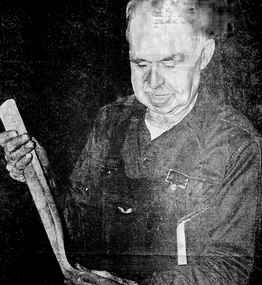
... After 1914 when mining declined, it became the Golden City Implement boundary and the name can still be seen painted on on the façade which faces the intersection of Marong Road (Calder highway) and Eaglehawk Road. ...After 1914 when mining declined, it became the Golden City Implement boundary and the name can still be seen painted on on the façade which faces the intersection of Marong Road (Calder highway) and Eaglehawk Road. ...This foundry had been a landmark in Mt Korong Road for many years. It began with an Osborne and Mitchell. After 1914 when mining declined, it became the Golden City Implement boundary and the name can still be seen painted on on the façade which faces the intersection of Marong Road (Calder highway) and Eaglehawk Road. The interior is a mass of used and un-used machinery scattered amongst modern lathes and more modern apparatus. The yard was a fascinating graveyard of past times, with old mining and agricultural scrap everywhere mixed up with coke and slag from the smelting sheds at the rear. A feature of the foundry was the manufacturer of cast iron lace. This document provides a historical and contemporary overview of the Osborne family's blacksmith and metalworking business in Bendigo, highlighting its longevity, operations, and significance: The business dates back to at least 1855, originally starting as a general store before evolving into a metalworking factory. The original founders were Osborne and Mitchell; Mitchell left early on, and the business changed hands several times before being acquired by Oscar Osborne (not related to the original Osborne founder). Oscar Osborne managed the machine shop and foundry, eventually acquiring it. His sons, Charles and Walter, now run the business with Stan, a descendant of the original founder. The current operators are Charles and Walter Osborne (brothers) and Stan (a descendant of the original founder but not directly related to the brothers). The business is known for its continuity and resilience, surviving as one of the oldest in Bendigo while others have disappeared or are newcomers. The workshop covers about a third of an acre and houses a large array of machinery and tools (nearly 200 between the three operators). The Osbornes pride themselves on traditional skills and methods, many of which are being lost in modern times. They are renowned for repairing a wide range of metal items, especially for antique dealers, and for producing high-quality crowbars and decorative iron lace for both restoration and new construction. Much of their work comes from Adelaide, and they maintain a steady demand for their specialized services. T he foundry and machine shop are considered landmarks in Bendigo, located on Eaglehawk Road opposite the Marong turn-off.The business was deeply embedded in the local community and history, with the Osborne name still prominent in the district.National Trust Survey Data Sheet and article from the Bendigo Advertiser November 4th 1981. Osbornes Ironbark Foundry This items contains the following documents 3084.47a Bendigo advertiser Article 4th November 1981 "Bendigo Firm is Still Going Strong" 3084.47b National Trust Data Survey Sheet July 9th 1977 3084.47c Black and White photo of Charles Osbornehistory, national trust bendigo collection, bendigo, foundary, iron bark bendigo -
 Warrnambool and District Historical Society Inc.
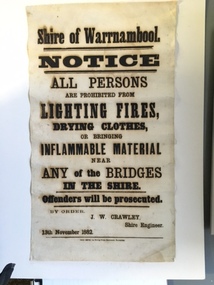
Document, Shire of Warrnambool Fire - Washing-Bridge 1882, 1882
... Much of it was incorporated into the Moyne Shire in the 1990's with some being included into the boundaries of City of Warrnambool. ...Much of it was incorporated into the Moyne Shire in the 1990's with some being included into the boundaries of City of Warrnambool. This banner is an interesting piece of history. ...This notice relates to the prohibition of lighting fires,drying clothes or bringing inflamable material near any of the bridges in the shire. Offenders will be prosecuted. With a date of 1882 and the fact that bridges were mostly made of wood, it would have been of concern that the destruction of bridges was not only of great inconvenience but also of considerable expense. But the reality of bridges providing shelter and warmth in the colder months and the ensuring fires and burnt bridges has more than likely precipitated this notice. J W Crawley was shire engineer from 1876 until 1895 and for 10 of those years he trained his son J W Crawley who succeeded his father and served in the position for 40 years.He in turn was succeeded by his son Rolf Crawley in 1935. In 1963 the bridge over the Hopkins Falls at Wangoom was named the Crawley bridge in honour of service to the Shire of Warrnambool by members of the Crawley family. The Shire of Warrnambool was proclaimed in 1863 and covered an area of over 600 square miles. Much of it was incorporated into the Moyne Shire in the 1990's with some being included into the boundaries of City of Warrnambool. This banner is an interesting piece of history. It shows the issues confronting early settlers such as shelter and the chores of daily life but also the importance placed on infrastructure which was slowly taking place around the district. It was in the era of drainage and roadworks and hence bridges were an important part of that infrastructure. The name J W Crawley is one of importance in the Warrnambool district for his service over many years. Rectangular piece of cloth printed in black ink. The back is plain.Shire of Warrnambool By order of J W Crawley Shire Engineer, 13th November 1882. Thos Smith gas Printing Works Koroit Street Warrnambool.warrnambool, shire of warrnambool, bridges of warrnambool shire, j w crawley, warrnambool shire engineer, crawleys of warrnambool -
 Warrnambool and District Historical Society Inc.
Booklet, Allansford Progress Association, Second half of 20th century
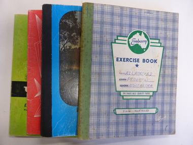
... Allansford is a settlement about 9 kilometres from Warrnambool and most of the town area is now within the boundaries of the Warrnambool City Council. The association was re-formed in November 1966 after the demise of an earlier group. ...Allansford is a settlement about 9 kilometres from Warrnambool and most of the town area is now within the boundaries of the Warrnambool City Council. The association was re-formed in November 1966 after the demise of an earlier group. ...These four exercise books give documentation on the activities of the Allansford Progress Association (1966 to 1988). Allansford is a settlement about 9 kilometres from Warrnambool and most of the town area is now within the boundaries of the Warrnambool City Council. The association was re-formed in November 1966 after the demise of an earlier group. The members of the group campaigned in areas of local concern – T. V. reception, drainage and sewerage, postal services, sports facilities including the development of the Speedway, housing development, road proposals, waste management and disaster plans. These books are of interest in that they provide an overview of the history of a local organization. They will be useful for research. These are four exercise books - three Minutes books, and one Accounts book, from the Allansford Progress Association (1966-1988). The exercise books have coloured covers, (blue and white checkered, green, red and blue). Two are bound with tape and two are stapled. There are some loose sheets in all of the books. All the entries are handwritten. On front covers: ‘Allansford Progress Association’allansford progress association, history of allansford, history of warrnambool -
 Warrnambool and District Historical Society Inc.
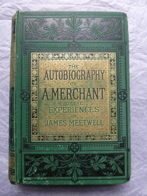
Book, The Autography of a Merchant, late 19th century
... Allansford is about ten kilometres from the Warrnambool city area and most of the township is now within the boundaries of the City of Warrnambool. ...Allansford is about ten kilometres from the Warrnambool city area and most of the township is now within the boundaries of the City of Warrnambool. ...This book was given in 1886 as a prize to Annie Egerton from Allansford State School. The prize was for recitation. Allansford State School No. 3 was opened in 1856 as a National School and is still operating. Allansford is about ten kilometres from the Warrnambool city area and most of the township is now within the boundaries of the City of Warrnambool. John Jones was the Head Master of the school from 1867 to 1891. No details have been found on Annie Egerton or her family This book is of interest because it concerns 19th century Allansford State School, Head Master John Jones and pupil Annie Egerton. It is also a book of antiquarian interest. This is a hard cover book of 436 pages. It has a green cover with gold and black ornamentation and black and green lettering. The pages are edged with gold colouring. The book has 36 chapters telling the story of the merchant, James Meetwell and some pages at the back giving details of other books available from the publishers, Ward, Lock & Co. The cover is somewhat soiled. There is an inscription inside the front cover with handwriting in black ink and the word ‘Reciting’ written in pencil on the second page. ‘Allansford S. School, 3, Presented to A. Egerton for Reciting, 19-4-86, J.E.Jones, teacher’ ‘Reciting’ annie egerton, allansford primary school, john jones,, allansford state school, history of allansford