Showing 5510 items matching " crown"
-
 Buninyong & District Historical Society
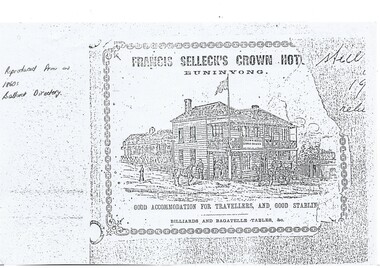
Photograph - Advertisement, Francis Selleck's Crown Hotel Buninyong
... Francis Selleck's Crown Hotel Buninyong...The Crown Hotel was a one of two very early hotels in Buninyong and has played a significant part in the local community ever since...An illustration advertising Francis Selleck's Crown Hotel from an 1860's Ballarat Directory...Francis Selleck's Crown Hotel, Buninyong. Good Accommodation for Travellers, and Good Stabling. ...Buninyong & District Historical Society Old Court House, Buninyong Town Hall 313 Learmonth Street Buninyong goldfields The Crown Hotel was a one of two very early hotels in Buninyong and has played a significant part in the local community ever since This photograph is a record of Buninyong and District Historical Society's ongoing activities in areas of local significance Buninyong Crown Hotel Francis Selleck Warrenheip Street Francis Selleck's Crown Hotel, Buninyong. ...The Crown Hotel was a one of two very early hotels in Buninyong and has played a significant part in the local community ever sinceThis photograph is a record of Buninyong and District Historical Society's ongoing activities in areas of local significance An illustration advertising Francis Selleck's Crown Hotel from an 1860's Ballarat DirectoryFrancis Selleck's Crown Hotel, Buninyong. Good Accommodation for Travellers, and Good Stabling. Billiards and Bagatelle Tables, &c.buninyong, crown hotel, francis selleck, warrenheip street -
 Emerald Museum & Nobelius Heritage Park
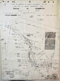
Map - Municipality Road Classification - Beaconsfield-Emerald Rd., Shire of Gembrook 1973, Title Survey Division, Crown Description - Part of Crown Allotment 44, Parish of Gembrook, County of Mornington, c1973
... Title Survey Division, Crown Description - Part of Crown Allotment 44, Parish of Gembrook, County of Mornington...Image of Crown Survey Map for crown allotment 44 (Beaconsfield-Emerald Rd.) parish of Gembrook, County of Mornington...Title Survey Division/Crown Description/Part of Crown Allotment 44, Parish of Gembrook, County of Mornington/Municipality Road Classification, Shire of Berwick, Beaconsfeld-Emerald Rd. ...Emerald Museum & Nobelius Heritage Park 5 Crichton Rd Emerald yarra-valley-and-the-dandenong-ranges Title Survey Division/Crown Description/Part of Crown Allotment 44, Parish of Gembrook, County of Mornington/Municipality Road Classification, Shire of Berwick, Beaconsfeld-Emerald Rd. ...Image of Crown Survey Map for crown allotment 44 (Beaconsfield-Emerald Rd.) parish of Gembrook, County of MorningtonTitle Survey Division/Crown Description/Part of Crown Allotment 44, Parish of Gembrook, County of Mornington/Municipality Road Classification, Shire of Berwick, Beaconsfeld-Emerald Rd. (MR)/Francis J Webber of Kirkpatrick & Webber, 285 Maroondah Hwy., Ringwood/(Signed) - Principal Title Survey Office 16.1.73/SP13461 -
 Flagstaff Hill Maritime Museum and Village
Separator
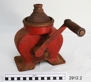
... Hand-cranked separating maching, made in Sweden for Melbourne Crown Separator Co. Pty Ltd. Machine is used for separating cream from milk, with the machine speed being 70 revs per minute....Hand-crank operated milk separator, small, painted red, Crown Separator Co Pty Ltd. Base and spinning mechanism only (mechanism spins very rettly). ...Stamped on handle "70 per minute", Stamped on body "S7071", Manufacturer plate "SYLVIA NO. 19/ MADE IN SWEDEN / CROWN SEPARATOR CO PTY LTD / 547 FLINDERS ST, MELBOURNE" ......Crown Separator Co. Pty Ltd...McInnes Crown Separator Co. Pty Ltd ...Hand-cranked separating maching, made in Sweden for Melbourne Crown Separator Co. Pty Ltd. Machine is used for separating cream from milk, with the machine speed being 70 revs per minute.Separator machine. Hand-crank operated milk separator, small, painted red, Crown Separator Co Pty Ltd. Base and spinning mechanism only (mechanism spins very rettly). Stamped on handle "70 per minute", Stamped on body "S7071", Manufacturer plate "SYLVIA NO. 19/ MADE IN SWEDEN / CROWN SEPARATOR CO PTY LTD / 547 FLINDERS ST, MELBOURNE" Stamped on handle "70 per minute", Stamped on body "S7071", Manufacturer plate "SYLVIA NO. 19/ MADE IN SWEDEN / CROWN SEPARATOR CO PTY LTD / 547 FLINDERS ST, MELBOURNE" flagstaff hill, warrnambool, shipwrecked-coast, flagstaff-hill, flagstaff-hill-maritime-museum, maritime-museum, shipwreck-coast, flagstaff-hill-maritime-village, milk separator, cream separator, dairy machinery, farming machinery, crown separator co pty ltd -
 Emerald Museum & Nobelius Heritage Park
Map - Municipality Road Classification - Wellington Rd. (part) - Near Kitty Street, Crown Survey map - Crown allotments 106F2 & 106 G1 - Wellington Rd. near Kitty Street, c1972
... Crown Survey map - Crown allotments 106F2 & 106 G1 - Wellington Rd. near Kitty Street...Image of Title survey - Part of Crown Allotments 106F2 and 106G1 - Wellington Road, Shire of Sherbrooke ...SP12969/Title Survey Division/Crown Description/Part of Crown Alloments 106F2, 106F3 and 106G1, Parish of Narree Worran, County of Mornington/Municipality Road Classification/Shire of Sherbrooke, Wellington Road/(signed) Rossley Paul Gardner of Kirkpatrick & Webber, 280 Maroondah Highway, Ringwood, 29th March 1972/(Signed) S.R. ...CLARKE, Principal Title Survey Officer & Proper Officer 21.6.72 Image of Title survey - Part of Crown Allotments 106F2 and 106G1 - Wellington Road, Shire of Sherbrooke Crown Survey map - Crown allotments 106F2 & 106 G1 - Wellington Rd. near Kitty Street Map Municipality Road Classification - Wellington Rd. ...Image of Title survey - Part of Crown Allotments 106F2 and 106G1 - Wellington Road, Shire of Sherbrooke SP12969/Title Survey Division/Crown Description/Part of Crown Alloments 106F2, 106F3 and 106G1, Parish of Narree Worran, County of Mornington/Municipality Road Classification/Shire of Sherbrooke, Wellington Road/(signed) Rossley Paul Gardner of Kirkpatrick & Webber, 280 Maroondah Highway, Ringwood, 29th March 1972/(Signed) S.R. CLARKE, Principal Title Survey Officer & Proper Officer 21.6.72 -
 Anglesea and District Historical Society
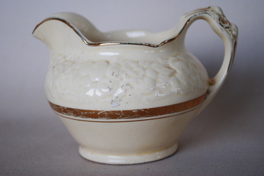
Cream Jug, Estimated 1937
... Crown Ducal Florentine Jug. Small off-white light cream colour. ...Crown illustration. Crown Ducal, Florentine Made in England...Crown Ducal - AG Richardson's Pottery...Anglesea and District Historical Society 5B McMillan Street Anglesea great-ocean-road jug creamer crown ducal Crown illustration. Crown Ducal, Florentine Made in England Crown Ducal Florentine Jug. ...Crown Ducal Florentine Jug. Small off-white light cream colour. The top half is embossed with Florentine pattern. Gold band around top of centre of jug. Gold decoration on handle.Crown illustration. Crown Ducal, Florentine Made in Englandjug, creamer, crown ducal -
 Emerald Museum & Nobelius Heritage Park
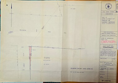
Map - Municipality Road Classification - Wellington Rd. (part), Crown Description - part of Crown Allotment 106 G1, Parish of Narree Worran, c1977
... Crown Description - part of Crown Allotment 106 G1, Parish of Narree Worran...Image of Title Survey, Part of Crown Allotment 106G1, Road Classification Shire of Sherbrooke Rd (Wellington Rd.)...SP14576/Title Survey Division/Crown Description/Part of Crown Allotment 106 G1, Parish of Narree Worran, County of Mornington/AMG Reference 7922/55/360800/5800100/Municipality Road Classification/Shire of Sherbrooke Road/Kenneth Douglas Adams, Country Roads Board, 60 Denmark Street, Kew, Surveyor, dated 15th November, 1977/Approved S.R. ...Crown Description - part of Crown Allotment 106 G1, Parish of Narree Worran Map Municipality Road Classification - Wellington Rd. ...Image of Title Survey, Part of Crown Allotment 106G1, Road Classification Shire of Sherbrooke Rd (Wellington Rd.)SP14576/Title Survey Division/Crown Description/Part of Crown Allotment 106 G1, Parish of Narree Worran, County of Mornington/AMG Reference 7922/55/360800/5800100/Municipality Road Classification/Shire of Sherbrooke Road/Kenneth Douglas Adams, Country Roads Board, 60 Denmark Street, Kew, Surveyor, dated 15th November, 1977/Approved S.R. CLARKE, Principal Surveyor and Proper Officer 21.11.77 -
 Emerald Museum & Nobelius Heritage Park
Map - Survey Map - Municipality Road Classification - Beaconsfield-Emerald Rd. (near Downey Rd.) 1972, Title Survey Division, Crown Description - part of Crown Allotments 39A and 39D, Parish of Gembrook, County of Mornington, c1972
... Title Survey Division, Crown Description - part of Crown Allotments 39A and 39D, Parish of Gembrook, County of Mornington...Image of Crown survey map - changes to allotments bordering Beaconsfield-Emerald Rd. near Downey Rd. in 1972...Title Survey Division/Crown Description/Part of Crown Allotments 39A and 39D, Parish of Gembrook,County of Mornington/Municipality Road Classification - Shire of Berwick, Beaconsfield - Emerald Rd, Upper Beaconsfield - Upper Pakenham Road/John L Dwyer of Fisher Cleeland Turner & Dwyer Pty. ...CLARKE - Principal Title Survey Officer 5.9.72/SP 13072 Image of Crown survey map - changes to allotments bordering Beaconsfield-Emerald Rd. near Downey Rd. in 1972 Title Survey Division, Crown Description - part of Crown Allotments 39A and 39D, Parish of Gembrook, County of Mornington Map Survey Map - Municipality Road Classification - Beaconsfield-Emerald Rd. ...Image of Crown survey map - changes to allotments bordering Beaconsfield-Emerald Rd. near Downey Rd. in 1972Title Survey Division/Crown Description/Part of Crown Allotments 39A and 39D, Parish of Gembrook,County of Mornington/Municipality Road Classification - Shire of Berwick, Beaconsfield - Emerald Rd, Upper Beaconsfield - Upper Pakenham Road/John L Dwyer of Fisher Cleeland Turner & Dwyer Pty. Ltd., 213 King Street, Melbourne - 14 April, 1972/S.R. CLARKE - Principal Title Survey Officer 5.9.72/SP 13072 -
 Camberwell Historical Society
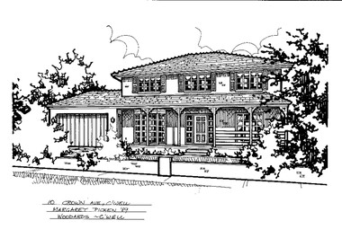
Drawing (series) - Architectural drawing, 10 Crown Avenue, Camberwell, 1989
... 10 Crown Avenue, Camberwell...Pen and ink architectural drawing on drafting film of 10 Crown Avenue, Camberwell by Margaret Picken...10 CROWN AVE., C'WELL / MARGARET PICKEN '89 / WOODARDS - C'WELL...The fact that each drawing is dated with the year it was created also proves a valuable record for house historians - since that date a number of the depicted properties have either been altered or demolished. artist architectural drawings margaret picken camberwell houses 10 CROWN AVE., C'WELL / MARGARET PICKEN '89 / WOODARDS - C'WELL Pen and ink architectural drawing on drafting film of 10 Crown Avenue, Camberwell by Margaret Picken 10 Crown Avenue, Camberwell Drawing Architectural drawing ...artist, architectural drawings, margaret picken, camberwell, housesartist, architectural drawings, margaret picken, camberwell, houses -
 Benalla Art Gallery
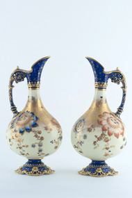
Ceramic, ROYAL CROWN DERBY, Pair of urns, 1889
... Urns in traditional Royal Crown Derby pattern of blues, flowers and gilded decoration....Verso: A: "ROYAL CROWN DERBY" above ROYAL CROWN DERBY maker's mark right of hole in centre; "ENGLAND" vertical to right of maker's mark in red underglaze; "1134/2553" in orange underglaze above maker's mark. ...ROYAL CROWN DERBY...Benalla Art Gallery Benalla Art Gallery Benalla Botanical Gardens Bridge Street Benalla high-country Victorian Ceramic Urns Decorated Gilded Floral Royal Crown Derby Verso: A: "ROYAL CROWN DERBY" above ROYAL CROWN DERBY maker's mark right of hole in centre; "ENGLAND" vertical to right of maker's mark in red underglaze; "1134/2553" in orange underglaze above maker's mark. ...Established: Derby, Derbyshire, England in 1750 by Andrew PlancheVictorianLedger Bequest, 1993Urns in traditional Royal Crown Derby pattern of blues, flowers and gilded decoration.Verso: A: "ROYAL CROWN DERBY" above ROYAL CROWN DERBY maker's mark right of hole in centre; "ENGLAND" vertical to right of maker's mark in red underglaze; "1134/2553" in orange underglaze above maker's mark. B: "ROYAL CROWN DERBY" above ROYAL CROWN DERBY maker's mark right of hole in centre; "ENGLAND" vertical to right ofmaker's mark in red underglaze; "1134/2553" in orange underglaze above maker's mark. "B" in orange underglaze to the far left of makers mark.ceramic, urns, decorated, gilded, floral, royal crown derby -
 Clunes Museum
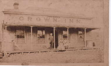
Photograph, CROWN INN, 1866
... CROWN INN....1 SEPIA COPY OF PHOTOGRAPH OF CROWN INN, SEPIA, SHOWING JOHN BARKER, PROPRIETOR; JANE BARKER, SARAH BARNES STANDING ON VERANDAH .2 BLACK AND WHITE ENLARGEMENT OF THE ABOVE PHOTOGRAPH PRINTED ON MATTE PHOTOGRAPHIC PAPER...CROWN INN JOHN BARKER...SYD DUNCAN, CLUNES, IS GREAT GRANDSON OF JANE BARKER crown inn JOHN BARKER JANE BARKER SARAH BARNES CROWN INN JOHN BARKER .1 SEPIA COPY OF PHOTOGRAPH OF CROWN INN, SEPIA, SHOWING JOHN BARKER, PROPRIETOR; JANE BARKER, SARAH BARNES STANDING ON VERANDAH .2 BLACK AND WHITE ENLARGEMENT OF THE ABOVE PHOTOGRAPH PRINTED ON MATTE PHOTOGRAPHIC PAPER CROWN INN Photograph PHOTOGRAPH ...1797 JOHN BARKER BORN CASTROKE CUMBERLAND. DETAILS IN SUPP FILE. SYD DUNCAN, CLUNES, IS GREAT GRANDSON OF JANE BARKER.1 SEPIA COPY OF PHOTOGRAPH OF CROWN INN, SEPIA, SHOWING JOHN BARKER, PROPRIETOR; JANE BARKER, SARAH BARNES STANDING ON VERANDAH .2 BLACK AND WHITE ENLARGEMENT OF THE ABOVE PHOTOGRAPH PRINTED ON MATTE PHOTOGRAPHIC PAPERCROWN INN JOHN BARKERcrown inn, john barker, jane barker, sarah barnes -
 Emerald Museum & Nobelius Heritage Park
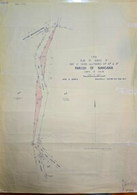
Map - Plan of Survey of Crown Allotments, Healesville - Koo Wee Rup Road, Shire of Berwick, c1969
... Plan of Survey of Crown Allotments, Healesville - Koo Wee Rup Road, Shire of Berwick...Image of Survey of Crown Allotments 61A, 61B & 81E, Parish of Nangana.../Plan of Survey of part of Crown Allotments 61A, 61B and 61E/Parish of Nangana, County of Evelyn/Shire of Berwick/Healesville0KooWeeRup Road.../Plan of Survey of part of Crown Allotments 61A, 61B and 61E/Parish of Nangana, County of Evelyn/Shire of Berwick/Healesville0KooWeeRup Road Image of Survey of Crown Allotments 61A, 61B & 81E, Parish of Nangana Plan of Survey of Crown Allotments, Healesville - Koo Wee Rup Road, Shire of Berwick Map Plan of Survey of Crown Allotments, Healesville - Koo Wee Rup Road, Shire of Berwick ...Image of Survey of Crown Allotments 61A, 61B & 81E, Parish of NanganaC.R.B./Plan of Survey of part of Crown Allotments 61A, 61B and 61E/Parish of Nangana, County of Evelyn/Shire of Berwick/Healesville0KooWeeRup Road -
 Mont De Lancey
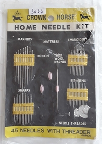
Functional object - Home Needle Kit, Crown Horse, Unknown
... A Crown Horse brand Home Needle Kit with 48 needles and a threader in a plastic bag. ...'Crown Horse Home Needle Kit Japan' The types of needles are as listed above....Crown Horse...The card has two black horses underneath a black crown at the top. Functional object Home Needle Kit Crown Horse ...A Crown Horse brand Home Needle Kit with 48 needles and a threader in a plastic bag. The needles are presented in gold strips attached to a black piece of cardboard.and are labelled as - Darners, Embroidery, Thick Wool Darner, Sharps, Betweens and a Threader. Two needles are missing, - a Bodkin and Mattress. The card has two black horses underneath a black crown at the top.'Crown Horse Home Needle Kit Japan' The types of needles are as listed above.sewing equipment, sewing, sewing needles -
 City of Moorabbin Historical Society (Operating the Box Cottage Museum)
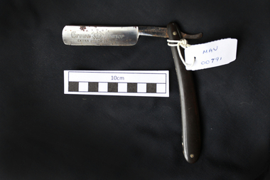
Personal Effects, cut-throat razor “Kings Crown’, 20thC
... For centuries the King’s Crown™ mark has been synonymous with exacting precision, hand-craftsmanship and quality. ...on blade ; KING'S / CROWN 'a crown trademark' RAZOR / EXTRA HOLLOW GROUND around 'trademark' ; SET READY FOR USE on steel handle; MADE IN GERMANY...Kings Crown Manufacturing Company ...For over a 100 years, the straight razors continue to be produced in Solingen (Germany). King's Crown™ cut-throat razors, straight razors, shaving equipment, steel blades, swords, weyersberg family, king crown pty ltd., solingen, germany, early settlers, market gardeners, moorabbin, bentleigh, cheltenham, on blade ; KING'S / CROWN 'a crown trademark' RAZOR / EXTRA HOLLOW GROUND around 'trademark' ; SET READY FOR USE on steel handle; MADE IN GERMANY A folding cut-throat razor Personal Effects, cut-throat razor “Kings Crown’ Kings Crown Manufacturing Company ...KING RAZOR MFG. CO.Pittsburgh, Pennsylvania; moved to Indiana, Pennsylvania in 1911.ca. 1904 - 1919 Marked "Made in Germany", although the company's offices were located at 118 E. 28th Street, New York City. ca. 1934-1943 Used the "THE KING OF RAZORS REGISTERED TRADEMARK" trademark. 47-1/2 and Trademark: Crown and Wolf. For 500 years the Weyersberg family has been producing the finest blades in the world. For centuries the King’s Crown™ mark has been synonymous with exacting precision, hand-craftsmanship and quality. For the first few hundred years the blades, made in Solingen, Germany (the “City of Blades”), were for swords. As times changed, the Weyersberg family transitioned into making cut throat razors. The Greb. Weyersberg™ family business.continue to place our mark on each and every product sold as we have done since first being able to register it in 1774. For over a 100 years, the straight razors continue to be produced in Solingen (Germany). King's Crown™A folding cut-throat razoron blade ; KING'S / CROWN 'a crown trademark' RAZOR / EXTRA HOLLOW GROUND around 'trademark' ; SET READY FOR USE on steel handle; MADE IN GERMANYcut-throat razors, straight razors, shaving equipment, steel blades, swords, weyersberg family, king crown pty ltd., solingen, germany, early settlers, market gardeners, moorabbin, bentleigh, cheltenham, -
 Whitehorse Historical Society Inc.
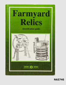
Book - Farmyard Relics, Crown Castleton publishers, C 1990
... Guide to Farmyard Relics - part of Crown Series....G. Walker Published Crown Castleton - Bendigo...Crown Castleton publishers...G. Walker Published Crown Castleton - Bendigo Book Farmyard Relics Crown Castleton publishers D.G. ...Guide to Farmyard Relics - part of Crown Series.Identification Guide - Farmyard equipment Illustrations and prices of equipment Printed in Australia - D. G. Walker Published Crown Castleton - BendigoAs aboveidentification guide -
 Emerald Museum & Nobelius Heritage Park
Map - Image of Plan of Deviation in Crown Allotments 57 & 58, Belgrave-Gembrook Rd., near Wright Rd. 1929, Plan of Deviation in Crown Allotments 57 & 58, Belgrave-Gembrook Rd., near Wright Rd. 1929, c1929
... Plan of Deviation in Crown Allotments 57 & 58, Belgrave-Gembrook Rd., near Wright Rd. 1929...Crown survey map showing plan of deviation in crown allotments 57 & 58, Belgrave-Gembrook Rd., near Wrights Rd., Parish of Gembrook...CRB/Plan of Deviation in Crown Allotments 57 & 58 and Part of Former Government Road/Parish of Gembrook, County of Evelyn/Belgrave-Gembrook Rd....BONWICK, Surveyor Licensed under Act 2679/5-2-29/Survey Plan No. 2239 Crown survey map showing plan of deviation in crown allotments 57 & 58, Belgrave-Gembrook Rd., near Wrights Rd., Parish of Gembrook Plan of Deviation in Crown Allotments 57 & 58, Belgrave-Gembrook Rd., near Wright Rd. 1929 Map Image of Plan of Deviation in Crown Allotments 57 & 58, Belgrave-Gembrook Rd., near Wright Rd. 1929 ...Crown survey map showing plan of deviation in crown allotments 57 & 58, Belgrave-Gembrook Rd., near Wrights Rd., Parish of GembrookCRB/Plan of Deviation in Crown Allotments 57 & 58 and Part of Former Government Road/Parish of Gembrook, County of Evelyn/Belgrave-Gembrook Rd./Scale 100 foot to an inch/Certification of Plan (Signed) W.P. BONWICK, Surveyor Licensed under Act 2679/5-2-29/Survey Plan No. 2239 -
 Buninyong & District Historical Society
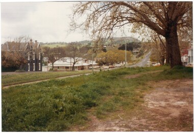
Photograph - Original Colour Photo, Streetscape of Learmonth St & Warrenheip St corner, Buninyong, taken from southwest, showing Crown Hotel and corner store, 1982
... Streetscape of Learmonth St & Warrenheip St corner, Buninyong, taken from southwest, showing Crown Hotel and corner store....The photo shows the streetscape of the corner of Learmonth and Warrenheip Sts, Buninyong, taking in the Crown Hotel and corner store (before redecoration)....Streetscape of Learmonth St & Warrenheip St corner, Buninyong, taken from southwest, showing Crown Hotel and corner store....Buninyong Crown Hotel corner shop Learmonth Street Warrenheip Street Streetscape "1982" Streetscape of Learmonth St & Warrenheip St corner, Buninyong, taken from southwest, showing Crown Hotel and corner store. ...The photo shows the streetscape of the corner of Learmonth and Warrenheip Sts, Buninyong, taking in the Crown Hotel and corner store (before redecoration).The photo shows former decoration of the Crown Hotel and corner store. From where the photo was taken, it also shows the avenue of elm trees before the service road was built on this western part of Learmonth St.Streetscape of Learmonth St & Warrenheip St corner, Buninyong, taken from southwest, showing Crown Hotel and corner store."1982"buninyong, crown hotel, corner shop, learmonth street, warrenheip street, streetscape -
 Moorabbin Air Museum
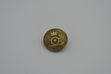
Uniform (item) - Military Uniform Button, Royal Artillery, with King's Crown (Tudor Crown) 12mm Dia
... Military Uniform Button, Royal Artillery, with King's Crown (Tudor Crown) 12mm Dia....Military Uniform Button, Royal Artillery, with King's Crown (Tudor Crown) 12mm Dia....Manufactured by Smith& Wright Ltd Birmingham Military Uniform Button, Royal Artillery, with King's Crown (Tudor Crown) 12mm Dia. Military Uniform Button, Royal Artillery, with King's Crown (Tudor Crown) 12mm Dia. ...Manufactured by Smith& Wright Ltd Birmingham -
 Coal Creek Community Park & Museum
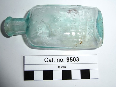
Bottle, glass, c.1908 - c.1938
... Tuesday 6 January 1925, page 4, 'Iona Cordial Extract, made by Crown Chemical Co. City Road, South Melbourne'. source Trove....'TRADE MARK IONA CROWN CHEMICAL CO MELB' on side. AGM monogram on base......Crown Chemical Company...Tuesday 6 January 1925, page 4, 'Iona Cordial Extract, made by Crown Chemical Co. City Road, South Melbourne'. source Trove. cordial 'TRADE MARK IONA CROWN CHEMICAL CO MELB' on side. ...Border Watch (Mt. Gambier South Australia) newspaper, Advertisement. Tuesday 6 January 1925, page 4, 'Iona Cordial Extract, made by Crown Chemical Co. City Road, South Melbourne'. source Trove.Pale aqua tinted clear glass bottle, ellipse shaped in cross section, embossed text on one side and monogram on base. Slightly asymmetrical, glass surface has some oxidisation (may have been buried or burnt).'TRADE MARK IONA CROWN CHEMICAL CO MELB' on side. AGM monogram on basecordial -
 Victorian Harness Racing Heritage Collection at Lord's Raceway Bendigo
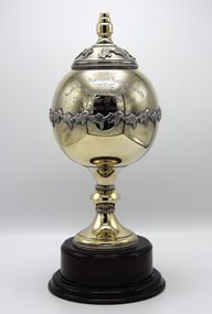
Memorabilia - Silver trophy, Maori's Crown, 1998 Australian Harness Racing Award, Vancleve Trophy
... Maori's Crown, 1998 Australian Harness Racing Award, Vancleve Trophy ...Maori's Crown (The Contender Imp P 1.54.0 - Maori Mara Vic Tr 2.9.2 (Bravado Hanover)) Bay Mare. ...1998 / Australian Harness Racing Award / Vancleve Trophy / 2yo trotter of the year / Maori's Crown...Trainer R McD Healy. Maori's Crown raced from 1998 (2yo) through to 2001 (5yo). ...Maori's Crown (The Contender Imp P 1.54.0 - Maori Mara Vic Tr 2.9.2 (Bravado Hanover)) Bay Mare. Foaled 1995 (9th Foal). Breeder/Owner: R McD Healy & Co Pty Ltd. Trainer R McD Healy. Maori's Crown raced from 1998 (2yo) through to 2001 (5yo). Career: 8 wins 1 second 5 thirds 32 starts $57,060 2.06.2 Winning Drivers: BR Gath (4) BR Healy (3) MN Wishart (1). Won on 4 Tracks: Moonee Valley (5) Bendigo (1) Maryborough (1) Ballarat (1)1998 Vancleve Trophy for 2yo Trotting Filly of the Year won by Maori's Crown. 2yo Season record: 5 wins 0 seconds 1 third 6 starts $44,150 2.6.2 Edgar Tatlow Memorial 2yo Trotters / Heat & Final Vicbred Super Series 2yo Trotters / Heat Breeders Crown 2yo Trotters (3rd in Final.Globe shaped1998 / Australian Harness Racing Award / Vancleve Trophy / 2yo trotter of the year / Maori's Crowntrophy, 1998, trotter, maoris crown, vancleve trophy, australian harness racing award, ric healy, br healy, bryan healy, br gath, brian gath, b gath, r healy, b healy, r mcd healy -
 Surrey Hills Historical Society Collection
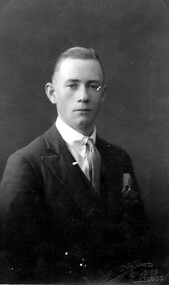
Photograph, Jack Sneddon
... 'Crown/ Studios/ Melbourne' impressed on original in lower RH corner....Crown Studios...Crown Studios...Jack Sneddon Photograph Crown Studios Crown Studios ...John William (Jack) was the son of William and Mary Sneddon and brother of Alan. William Sneddon was a postman in Surrey Hills for many years. His father James ran an estate agency in Surrey Hills established by his father in the 1880s. William's wife was Mary Sneddon (nee Bird). Jack was born in 1908 in Camberwell. In 1937 his address was 19 Albert Street, Surrey Hills. The donor Robin da Costa-Adams is related to the Sneddon family through her first marriage.Formal sepia head and shoulders photo of Jack Sneddon dressed in a suit and tie. 'Crown/ Studios/ Melbourne' impressed on original in lower RH corner.jack sneddon, john william sneddon, (miss) mary bird, (mrs) mary sneddon, james sneddon, crown studios -
Emerald Museum & Nobelius Heritage Park
Map - Plan of Deviation in Crown Allotments 57 & 58 Wright Rd. & McNamara Rd. 1929, Property Acquisition Settlement Advice and plan of deviation in crown allotments in Wright Rd. and McNamara Rd, C 1929 & C 1984
... Property Acquisition Settlement Advice and plan of deviation in crown allotments in Wright Rd. and McNamara Rd....Images of map and letter pertaining to land acquisition and deviation plan for crown allotments adjacent to Crown Allotments 57 & 58.../Survey Plan 2239/Owner Roy and Judith Ward/dated 10 September, 1984/Signed P J McCulloch, General Manager Admin/ATTACHED MAP/Plan of Deviation in Crown Allotments 57 & 58and part of the formergovernment road, Parish of Gembrook, county of Evelyn/ certified by W.P. ...BONWICH - 5.2.29 Images of map and letter pertaining to land acquisition and deviation plan for crown allotments adjacent to Crown Allotments 57 & 58 Property Acquisition Settlement Advice and plan of deviation in crown allotments in Wright Rd. and McNamara Rd. ...Images of map and letter pertaining to land acquisition and deviation plan for crown allotments adjacent to Crown Allotments 57 & 58Road Construction Authority/Property Acquisition - Settlement advice letter addressd to General manager of Shire of Sherbrooke, Glanfern Way Upwey/Road - Belgrave-Gembrook Rd./Survey Plan 2239/Owner Roy and Judith Ward/dated 10 September, 1984/Signed P J McCulloch, General Manager Admin/ATTACHED MAP/Plan of Deviation in Crown Allotments 57 & 58and part of the formergovernment road, Parish of Gembrook, county of Evelyn/ certified by W.P. BONWICH - 5.2.29 -
 Whitehorse Historical Society Inc.
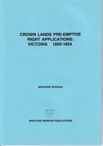
Administrative record - Crown Land Valuations and Applications, Government Printer - John FERRES, Crown Lands Pre-emptive Right Applications: Victoria 1850-1854, 1855
... Crown Lands Pre-emptive Right Applications: Victoria 1850-1854...This document contains the return of all lands alienated from the Crown (in Victoria) and applied for under Pre-Emptive right with the name of Purchaser, etc on 20 April 1855....Contains a valuation for Crown Lands applications under pre-emptive right by Victorian county, giving names of applicants name of run, area, and remarks. ...Crown Lands Pre-emptive Right Applications: Victoria 1850-1854 Administrative record Crown Land Valuations and Applications Government Printer - John FERRES ...Contains a valuation for Crown Lands applications under pre-emptive right by Victorian county, giving names of applicants name of run, area, and remarks.Contains a valuation for Crown Lands applications under pre-emptive right by Victorian county, giving names of applicants name of run, area, and remarks. Contains a valuation for Crown Lands applications under pre-emptive right by Victorian county, giving names of applicants name of run, area, and remarks. clarke andrew, anglesey, evelyn, bourke, dalhousie, dundas, follett, grant, hampden, heytesbury, normanby, polwarth, ripon, talbot, villiers, district of murray, district of wimmera, district of western port, early settlement, mornington -
 Wonga Park Community Cottage History Group
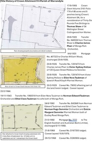
Document - Title History, Title History of Crown Allotment 9A Wonga Park
... Title History of Crown Allotment 9A Wonga Park...The allotment history for Crown allotment 9A Wonga Park (after Crown leases from 1893) starts in 1906 with the Crown granting 46 acres and 6 perches to Thomas Shaw, an iron worker in Collingwood. ...Archive file for Crown allotment 9A containing title history documents and research. ...Wonga Park Community Cottage History Group Unit 1, 9 – 13 Old Yarra Road Wonga Park melbourne The allotment history for Crown allotment 9A Wonga Park (after Crown leases from 1893) starts in 1906 with the Crown granting 46 acres and 6 perches to Thomas Shaw, an iron worker in Collingwood. ...The allotment history for Crown allotment 9A Wonga Park (after Crown leases from 1893) starts in 1906 with the Crown granting 46 acres and 6 perches to Thomas Shaw, an iron worker in Collingwood. The history of registered owners who have a connection with the allotment include Charles James Phair (1920), Victor Sydney Hollow, Ellen Nora Taubman, Norman Edward Taubman, Ethel Clara Taubman, Norman Hugo Semmler, Dulcie Margaret Semmler, Wesley Charles Robinson, Margaret Joyce Robinson, Roslan Pty Ltd, Aktip Pty. Ltd., Hendricus Martinus Versteegen, Marie Therese Versteegen, Gary Grey Hutchins and Annette Louise Hutchins, Frederick Allen Lang, Beverley Elizabeth Lang, Gary John Cole, Kay Jean Cole, Trevor James Lethlean and Rosalie Dawn Lethlean, inter alia.Archive file for Crown allotment 9A containing title history documents and research. Documents include copies of Crown Grant Volume 3161 Folio 174, Certificates of Titles Volume 9274 Folio 298, Volume 9274 Folio 299, Volume 9274 Folio 300, Volume 9538 Folio 560, Volume 10155 Folio452, Volume 10155 Folio 453, Volume10177 Folio 343, Plan of consolidation No. 354507C and Plan of Subdivision No. 331410J -
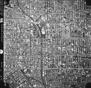
 St Kilda Historical Society
Photograph - Photo map, Department of Crown Lands and Survey (1857-1983), 22/01/1970
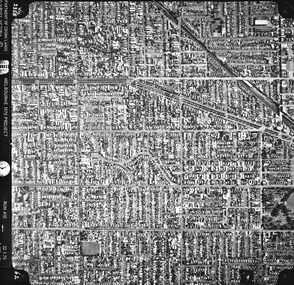
... One of a series of photo-maps produced for the Department of Crown Lands and Survey (1857-1983). For correlation with a current map, and access to other historical photo maps of Victoria, see the Historic Photo-Maps Index published by the Department of Environment, Land, Water and Planning at https://services.land.vic.gov.au/DELWPmaps/historical-photomaps/...Vic 2358 Department of Crown Lands and Survey Victoria,.© Melbourne 1970 Project Run 41E 22.1.70 5,100 ASL 62...Department of Crown Lands and Survey (1857-1983)...St Kilda Historical Society St Kilda Branch Library 150 Carlisle Street St Kilda melbourne One of a series of photo-maps produced for the Department of Crown Lands and Survey (1857-1983). For correlation with a current map, and access to other historical photo maps of Victoria, see the Historic Photo-Maps Index published by the Department of Environment, Land, Water and Planning at https://services.land.vic.gov.au/DELWPmaps/historical-photomaps/ Caulfield Caulfield North St Kilda EAst Armadale 1970 Vic 2358 Department of Crown Lands and Survey Victoria,.© Melbourne 1970 Project Run 41E 22.1.70 5,100 ASL 62 Black and white aerial photograph Photograph Photo map Department of Crown Lands and Survey (1857-1983) ...One of a series of photo-maps produced for the Department of Crown Lands and Survey (1857-1983). For correlation with a current map, and access to other historical photo maps of Victoria, see the Historic Photo-Maps Index published by the Department of Environment, Land, Water and Planning at https://services.land.vic.gov.au/DELWPmaps/historical-photomaps/Black and white aerial photographVic 2358 Department of Crown Lands and Survey Victoria,.© Melbourne 1970 Project Run 41E 22.1.70 5,100 ASL 62caulfield, caulfield north, st kilda east, armadale, 1970 -
 St Kilda Historical Society
Photograph - Photo map, Department of Crown Lands and Survey (1857-1983), 22/01/1970
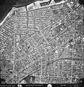
... One of a series of photo-maps produced for the Department of Crown Lands and Survey (1857-1983). For correlation with a current map, and access to other historical photo maps of Victoria, see the Historic Photo-Maps Index published by the Department of Environment, Land, Water and Planning at https://services.land.vic.gov.au/DELWPmaps/historical-photomaps/...Vic 2358 Department of Crown Lands and Survey Victoria,.© Melbourne 1970 Project Run 42E 22.1.70 5,100 ASL 77...Department of Crown Lands and Survey (1857-1983)...St Kilda Historical Society St Kilda Branch Library 150 Carlisle Street St Kilda melbourne One of a series of photo-maps produced for the Department of Crown Lands and Survey (1857-1983). For correlation with a current map, and access to other historical photo maps of Victoria, see the Historic Photo-Maps Index published by the Department of Environment, Land, Water and Planning at https://services.land.vic.gov.au/DELWPmaps/historical-photomaps/ St Kilda St Kilda East St Kilda Marina Elwood Elwood canal Elsternwick Park Point Ormond Balaclava MC Moran Reserve Ripponlea St Kilda Botanical Gardens Peanut farm 1970 Vic 2358 Department of Crown Lands and Survey Victoria,.© Melbourne 1970 Project Run 42E 22.1.70 5,100 ASL 77 Black and white aerial photograph Photograph Photo map Department of Crown Lands and Survey (1857-1983) ...One of a series of photo-maps produced for the Department of Crown Lands and Survey (1857-1983). For correlation with a current map, and access to other historical photo maps of Victoria, see the Historic Photo-Maps Index published by the Department of Environment, Land, Water and Planning at https://services.land.vic.gov.au/DELWPmaps/historical-photomaps/Black and white aerial photographVic 2358 Department of Crown Lands and Survey Victoria,.© Melbourne 1970 Project Run 42E 22.1.70 5,100 ASL 77st kilda, st kilda east, st kilda marina, elwood, elwood canal, elsternwick park, point ormond, balaclava, mc moran reserve, ripponlea, st kilda botanical gardens, peanut farm, 1970 -
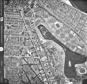
 St Kilda Historical Society
Photograph - Photo map, Department of Crown Lands and Survey, 22/01/1970
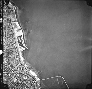
... One of a series of photo-maps produced for the Department of Crown Lands and Survey (1857-1983). For correlation with a current map, and access to other historical photo maps of Victoria, see the Historic Photo-Maps Index published by the Department of Environment, Land, Water and Planning at https://services.land.vic.gov.au/DELWPmaps/historical-photomaps/...Vic 2358 Department of Crown Lands and Survey Victoria,.© Melbourne 1970 Project Run 43E 22.1.70 5,100 ASL 208...Department of Crown Lands and Survey ...St Kilda Historical Society St Kilda Branch Library 150 Carlisle Street St Kilda melbourne One of a series of photo-maps produced for the Department of Crown Lands and Survey (1857-1983). For correlation with a current map, and access to other historical photo maps of Victoria, see the Historic Photo-Maps Index published by the Department of Environment, Land, Water and Planning at https://services.land.vic.gov.au/DELWPmaps/historical-photomaps/ Elwood Elwood beach Point Ormond Elwood Park Elwood canal MC Moran Reserve 1970 Vic 2358 Department of Crown Lands and Survey Victoria,.© Melbourne 1970 Project Run 43E 22.1.70 5,100 ASL 208 Black and white aerial photograph Photograph Photo map Department of Crown Lands and Survey ...One of a series of photo-maps produced for the Department of Crown Lands and Survey (1857-1983). For correlation with a current map, and access to other historical photo maps of Victoria, see the Historic Photo-Maps Index published by the Department of Environment, Land, Water and Planning at https://services.land.vic.gov.au/DELWPmaps/historical-photomaps/Black and white aerial photographVic 2358 Department of Crown Lands and Survey Victoria,.© Melbourne 1970 Project Run 43E 22.1.70 5,100 ASL 208elwood, elwood beach, point ormond, elwood park, elwood canal, mc moran reserve, 1970 -
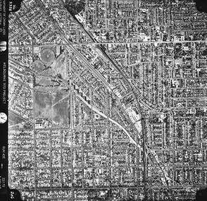
 St Kilda Historical Society
Photograph - Photo map, Department of Crown Lands and Survey, 22/01/1970
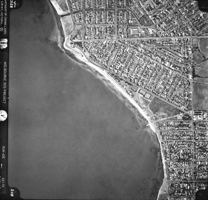
... One of a series of photo-maps produced for the Department of Crown Lands and Survey (1857-1983). For correlation with a current map, and access to other historical photo maps of Victoria, see the Historic Photo-Maps Index published by the Department of Environment, Land, Water and Planning at https://services.land.vic.gov.au/DELWPmaps/historical-photomaps/...Vic 2358 Department of Crown Lands and Survey Victoria,.© Melbourne 1970 Project Run 42E 22.1.70 5,100 ASL 75...Department of Crown Lands and Survey ...St Kilda Historical Society St Kilda Branch Library 150 Carlisle Street St Kilda melbourne One of a series of photo-maps produced for the Department of Crown Lands and Survey (1857-1983). For correlation with a current map, and access to other historical photo maps of Victoria, see the Historic Photo-Maps Index published by the Department of Environment, Land, Water and Planning at https://services.land.vic.gov.au/DELWPmaps/historical-photomaps/ St Kilda St Kilda beach St Kilda marina Point Ormond St Kilda pier 1970 Vic 2358 Department of Crown Lands and Survey Victoria,.© Melbourne 1970 Project Run 42E 22.1.70 5,100 ASL 75 Black and white aerial photograph Photograph Photo map Department of Crown Lands and Survey ...One of a series of photo-maps produced for the Department of Crown Lands and Survey (1857-1983). For correlation with a current map, and access to other historical photo maps of Victoria, see the Historic Photo-Maps Index published by the Department of Environment, Land, Water and Planning at https://services.land.vic.gov.au/DELWPmaps/historical-photomaps/Black and white aerial photographVic 2358 Department of Crown Lands and Survey Victoria,.© Melbourne 1970 Project Run 42E 22.1.70 5,100 ASL 75st kilda, st kilda beach, st kilda marina, point ormond, st kilda pier, 1970 -
 St Kilda Historical Society
Photograph - Photo map, Department of Crown Lands and Survey, 22/01/1970
... One of a series of photo-maps produced for the Department of Crown Lands and Survey (1857-1983). For correlation with a current map, and access to other historical photo maps of Victoria, see the Historic Photo-Maps Index published by the Department of Environment, Land, Water and Planning at https://services.land.vic.gov.au/DELWPmaps/historical-photomaps/...Vic 2358 Department of Crown Lands and Survey Victoria,.© Melbourne 1970 Project Run 41E 22.1.70 5,100 ASL 64...Department of Crown Lands and Survey ...St Kilda Historical Society St Kilda Branch Library 150 Carlisle Street St Kilda melbourne One of a series of photo-maps produced for the Department of Crown Lands and Survey (1857-1983). For correlation with a current map, and access to other historical photo maps of Victoria, see the Historic Photo-Maps Index published by the Department of Environment, Land, Water and Planning at https://services.land.vic.gov.au/DELWPmaps/historical-photomaps/ St Kilda St Kilda cemetery Balaclava St Kilda East Windsor Caulfield North Alma Park 1970 Vic 2358 Department of Crown Lands and Survey Victoria,.© Melbourne 1970 Project Run 41E 22.1.70 5,100 ASL 64 Black and white aerial photograph Photograph Photo map Department of Crown Lands and Survey ...One of a series of photo-maps produced for the Department of Crown Lands and Survey (1857-1983). For correlation with a current map, and access to other historical photo maps of Victoria, see the Historic Photo-Maps Index published by the Department of Environment, Land, Water and Planning at https://services.land.vic.gov.au/DELWPmaps/historical-photomaps/Black and white aerial photographVic 2358 Department of Crown Lands and Survey Victoria,.© Melbourne 1970 Project Run 41E 22.1.70 5,100 ASL 64st kilda, st kilda cemetery, balaclava, st kilda east, windsor, caulfield north, alma park, 1970 -
 St Kilda Historical Society
Photograph - Photo map, Department of Crown Lands and Survey, 08/01/1970
... One of a series of photo-maps produced for the Department of Crown Lands and Survey (1857-1983). For correlation with a current map, and access to other historical photo maps of Victoria, see the Historic Photo-Maps Index published by the Department of Environment, Land, Water and Planning at https://services.land.vic.gov.au/DELWPmaps/historical-photomaps/...Vic 2345 Department of Crown Lands and Survey Victoria,.© Melbourne 1970 Project Run 40 8.1.70 5,100 ASL 77...Department of Crown Lands and Survey ...St Kilda Historical Society St Kilda Branch Library 150 Carlisle Street St Kilda melbourne One of a series of photo-maps produced for the Department of Crown Lands and Survey (1857-1983). For correlation with a current map, and access to other historical photo maps of Victoria, see the Historic Photo-Maps Index published by the Department of Environment, Land, Water and Planning at https://services.land.vic.gov.au/DELWPmaps/historical-photomaps/ Albert Park Fawkner Park South Yarra Middle Park Prahran Windsor St Kilda St Kilda West 1970 Vic 2345 Department of Crown Lands and Survey Victoria,.© Melbourne 1970 Project Run 40 8.1.70 5,100 ASL 77 Black and white arial photograph Photograph Photo map Department of Crown Lands and Survey ...One of a series of photo-maps produced for the Department of Crown Lands and Survey (1857-1983). For correlation with a current map, and access to other historical photo maps of Victoria, see the Historic Photo-Maps Index published by the Department of Environment, Land, Water and Planning at https://services.land.vic.gov.au/DELWPmaps/historical-photomaps/Black and white arial photographVic 2345 Department of Crown Lands and Survey Victoria,.© Melbourne 1970 Project Run 40 8.1.70 5,100 ASL 77albert park, fawkner park, south yarra, middle park, prahran, windsor, st kilda, st kilda west, 1970 -
 St Kilda Historical Society
Photograph - Photo map, 22/01/1970
... One of a series of photo-maps produced for the Department of Crown Lands and Survey (1857-1983). For correlation with a current map, and access to other historical photo maps of Victoria, see the Historic Photo-Maps Index published by the Department of Environment, Land, Water and Planning at https://services.land.vic.gov.au/DELWPmaps/historical-photomaps/...Vic 2358 Department of Crown Lands and Survey Victoria,.© Melbourne 1970 Project Run 43E 22.1.70 5,100 ASL 206...Department of Crown Lands and Survey ...St Kilda Historical Society St Kilda Branch Library 150 Carlisle Street St Kilda melbourne One of a series of photo-maps produced for the Department of Crown Lands and Survey (1857-1983). For correlation with a current map, and access to other historical photo maps of Victoria, see the Historic Photo-Maps Index published by the Department of Environment, Land, Water and Planning at https://services.land.vic.gov.au/DELWPmaps/historical-photomaps/ Elwood Elsternwick Elsternwick Park 1970 Vic 2358 Department of Crown Lands and Survey Victoria,.© Melbourne 1970 Project Run 43E 22.1.70 5,100 ASL 206 Black and white aerial photograph Photograph Photo map Department of Crown Lands and Survey ...One of a series of photo-maps produced for the Department of Crown Lands and Survey (1857-1983). For correlation with a current map, and access to other historical photo maps of Victoria, see the Historic Photo-Maps Index published by the Department of Environment, Land, Water and Planning at https://services.land.vic.gov.au/DELWPmaps/historical-photomaps/Black and white aerial photographVic 2358 Department of Crown Lands and Survey Victoria,.© Melbourne 1970 Project Run 43E 22.1.70 5,100 ASL 206elwood, elsternwick, elsternwick park, 1970