
Showing 4 items matching " dendy’s crown special survey parish of moorabbin county of bourke"
-
 Glen Eira Historical Society
Map - Daley Street, 49, Bentleigh
... Dendy’s Crown Special Survey Parish of Moorabbin County of Bourke...Bentleigh Daley Street Borrow William George Dendy’s Crown Special Survey Parish of Moorabbin County of Bourke Map Daley Street, 49, Bentleigh ...A one page typed letter, dated 23/11/1960, from Weigall and Crowther Solicitors, requesting a valuation of the property at 49 Daley Street, Bentleigh and forwarding a copy of the certificate of title for the property. The file also includes the copy of the certificate of title, dated 31/03/1926, with a hand drawn map (58mm x 60mm) of the property. The file also includes a copy of a two page typed response, dated 29/11/1960, from an unnamed valuator, providing a detailed description of the property and its value. The file also includes one page of handwritten working notes for the purposes of the valuation, dated 28/11/1960.bentleigh, daley street, borrow william george, dendy’s crown special survey parish of moorabbin county of bourke -
 City of Moorabbin Historical Society (Operating the Box Cottage Museum)
Flyer - Garfield Estate, Ormond
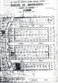
... Part f Dendy's Crown Special Survey - parish of Moorabbin - County of Bourke - Garfield Estate...Example of the progress of the Municipality of Moorabbin Draper Street Lord Street Hudson Street Blackshaw Street Tucker Road Ormond McKinnon Real Estate Part f Dendy's Crown Special Survey - parish of Moorabbin - County of Bourke - Garfield Estate Photocopy of the plan of the Garfield Estate, Ormond Flyer Garfield Estate, Ormond ...At the end of World War One, there was a renewed interest in residential land and a number of estates opened up in the Municipality of Moorabbin.Example of the progress of the Municipality of MoorabbinPhotocopy of the plan of the Garfield Estate, OrmondPart f Dendy's Crown Special Survey - parish of Moorabbin - County of Bourke - Garfield Estatedraper street, lord street, hudson street, blackshaw street, tucker road, ormond, mckinnon, real estate -
 City of Moorabbin Historical Society (Operating the Box Cottage Museum)
Document - Photocopy of Land Title 1881, c1881
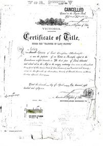
... This is a Certificate of Title for an acre of land in 'Tucker's Road' purchased by Jabez Gurr in 1881, in the area that was part of the Crown Block known as Henry Dendy's Special Survey 1841, in the Parish of Moorabbin, County of Bourke, Victoria. ...This is a Certificate of Title for an acre of land in 'Tucker's Road' purchased by Jabez Gurr in 1881, in the area that was part of the Crown Block known as Henry Dendy's Special Survey 1841, in the Parish of Moorabbin, County of Bourke, Victoria. ...This is a Certificate of Title for an acre of land in 'Tucker's Road' purchased by Jabez Gurr in 1881, in the area that was part of the Crown Block known as Henry Dendy's Special Survey 1841, in the Parish of Moorabbin, County of Bourke, Victoria. Following the 'Transfer of Land Statute' allotments in the area of Henry Dendy's Special Survey of 1841 were sold to early settlers. This Certificate of Title shows the passage of history in Moorabbin Shire . Jabez Gurr, a wheelwright, of East Brighton, now Bentleigh East, purchased an acre of land in 'Tucker's Road' , near Centre Road, in 1881. In 1889 he sold to a produce merchant, Robert Smith, and in April 1916 this block was purchased by William Henry George Box, a market gardener and relative of William and Elizabeth Box, who owned the land until 1926. The land was then purchased by Charles John Greenlaw Coates and remained with this family until 1971. All these Family names appear on Councils and Community Boards during the foundation and development of City of Moorabbin3 photocopied pages of the Certificate of Title for approximately 1 acre of land near the corner of Centre Road and Tucker Road, Parish of Moorabbin, County of Bourke, Victoria that was part of the 5,120 acre Henry Dendy Special Survey in Brighton in 1841 and purchased in 1881 by Jabez Gurr. It records subsequent proprietors up to 1971Stamped CANCELLED 12 OCT 1994 (top Right) / Entered in the Register Book / Vol.1245 Fol. 248877/ signed Henry Crowe / Assistant Registrar of Titles / Coat of Arms / VICTORIA / Certificate of Title / UNDER THE ' TRANSFER OF AND STATUTE' /dated ' eleventh day of April one thousand eight / hundred and eighty one' / signed 'Henry Crowe' / Assistant Registrar of Titles/ ENCUMBRANCES REFERRED TO / circular Stamp 'OFFICE OF TITLES VICTORIA' / Drawn and shaded on the left side is the area of land in "Tucker's" Road 3331/3 links fro Centre Road, 150 links x 6662/3 links / The measurements are in linksdendy henry, dendy's special survey 1841, brighton, moorabbin, bentleigh, market gardeners, early settlers, pioneers, wheelwrights, merchants, fruit gardens, markets, smith robert, box william henry george, gurr jabez, county of bourke, victoria, melbourne, land statutes, tucker road, centre road, box william, box elizabeth, box cottage museum -
Glen Eira Historical Society
Plan - Pascoe Avenue, 26, Bentleigh
... Pascoe Ave Land Subdivisions Land Values Bentleigh Pergolas Architectural features Parish of Moorabbin Plans Architectural styles County of Bourke Maps Brick Houses National Trustees Co Illustrations Dendy’s Crown Special Survey Plan Pascoe Avenue, 26, Bentleigh ...Document detailing two valuations by National Trustees Co of the property at 26 Pascoe Ave, Bentleigh, the first valuation is dated 14/07/1954 and the second dated 19/07/1957. Included are handdrawn plans, handwritten notes and typed valuations listing values of architectural features, and correspondence from National Trustees Co. for both 1954 and 1957. The 1954 documents were clearly used in the 1957 valuation.pascoe ave, land subdivisions, land values, bentleigh, pergolas, architectural features, parish of moorabbin, plans, architectural styles, county of bourke, maps, brick houses, national trustees co, illustrations, dendy’s crown special survey
