Showing 105 items matching " derrimut"
-
 Sunshine and District Historical Society Incorporated
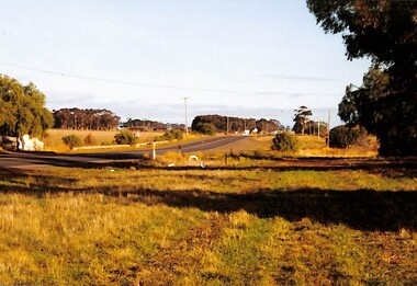
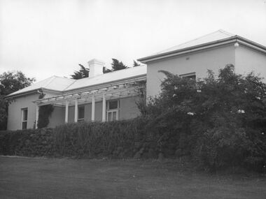
Photograph - Robinsons farm Derrimut, Johnson, Des, 31 May, 2004,(exact)|10 October, 2004(exact)|27 October, 2008(exact)
... ... Derrimut...5 photographic prints of scenes at or near Robinsons farm Derrimut...Photograph South side or front of Robinson Farm House 416 to 430 Boundary Road Derrimut dated 27 October 2008|Photograph Showing stone wall in front of Robinson Farm House 416 to 430 Boundary Road Derrimut dated 27 October 2008|Photograph Looking to Boundary Road Dry Stone Wall Shears quarters Robinson Farm House 416 to 430 Boundary Road Derrimut dated 27 October 2008|Photograph Horse Stables Robinson Farm House 416 to 430 Boundary Road Derrimut dated 10 October 2008|Photograph North side of Boundary Road near Foxly Lodge looking West over Laverton Creek to Robinsons Road along 316 to 340 North side Boundary Road I Des Johnson had slashed this grass and 5 large pine trees has been cut down 31 May 2005...Derrimut, Victoria, Australia...Donated by Des to Sunshine and District Historical Society. Robinsons Derrimut Photograph South side or front of Robinson Farm House 416 to 430 Boundary Road Derrimut dated 27 October 2008|Photograph Showing stone wall in front of Robinson Farm House 416 to 430 Boundary Road Derrimut dated 27 October 2008|Photograph Looking to Boundary Road Dry Stone Wall Shears quarters Robinson Farm House 416 to 430 Boundary Road Derrimut dated 27 October 2008|Photograph Horse Stables Robinson Farm House 416 to 430 Boundary Road Derrimut dated 10 October 2008|Photograph North side of Boundary Road near Foxly Lodge looking West over Laverton Creek to Robinsons Road along 316 to 340 North side Boundary Road I Des Johnson had slashed this grass and 5 large pine trees has been cut down 31 May 2005 5 photographic prints of scenes at or near Robinsons farm Derrimut Photograph Robinsons farm Derrimut Johnson, Des. ...Set of prints of photographs taken by Des Johnson. Donated by Des to Sunshine and District Historical Society.Photograph South side or front of Robinson Farm House 416 to 430 Boundary Road Derrimut dated 27 October 2008|Photograph Showing stone wall in front of Robinson Farm House 416 to 430 Boundary Road Derrimut dated 27 October 2008|Photograph Looking to Boundary Road Dry Stone Wall Shears quarters Robinson Farm House 416 to 430 Boundary Road Derrimut dated 27 October 2008|Photograph Horse Stables Robinson Farm House 416 to 430 Boundary Road Derrimut dated 10 October 2008|Photograph North side of Boundary Road near Foxly Lodge looking West over Laverton Creek to Robinsons Road along 316 to 340 North side Boundary Road I Des Johnson had slashed this grass and 5 large pine trees has been cut down 31 May 2005robinsons, derrimut -
 Melton City Libraries
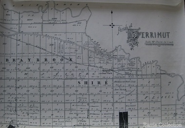
Map, Parish of Derrimut, 1931
... Parish of Derrimut...Map of the Parish of Derrimut...Melton City Libraries 31 McKenzie Street Melton melbourne Council Map of the Parish of Derrimut Parish of Derrimut Map Barrie Collection ...Map of the Parish of Derrimutcouncil -
 Sunshine and District Historical Society Incorporated
Document (item) - Mount Derrimut Homestead Complex Deer Park. Conservation Management Plan, Australand, April 2005
... Mount Derrimut Homestead Complex Deer Park. Conservation Management Plan... Derrimut...Mount Derrimut Homestead Complex Deer Park. Conservation Management Plan...Donated to Sunshine and District Historical Society Derrimut Deer Park conservation management plan constraints heritage listing Mount Derrimut Homestead history physical analysis Mount Derrimut Homestead Complex Deer Park. ...Donated to Sunshine and District Historical SocietyMount Derrimut Homestead Complex Deer Park. Conservation Management Plan derrimut, deer park, conservation management plan, constraints, heritage listing, mount derrimut homestead, history, physical analysis -
 Sunshine and District Historical Society Incorporated
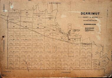
Map - Derrimut County of Bourke, Department of Lands and Survey, 1945
... Derrimut...Plan of Parish of Derrimut, County of Bourke, circa late 1950s. ...Derrimut, County of Bourke For Departmental use only By Authority Gourley Government Printer...Derrimut Map Derrimut, County of Bourke For Departmental use only By Authority Gourley Government Printer Plan of Parish of Derrimut, County of Bourke, circa late 1950s. ...Derrimut, County of Bourke For Departmental use only By Authority Gourley Government Printerderrimut, map -
 Sunshine and District Historical Society Incorporated
Map - Derrimut, County of Bourke Map, Department of Lands and Survey, circa 1950s
... Derrimut...Plan of Parish of Derrimut, County of Bourke, circa late 1950s. ..."Derrimut, County of Bourke" "For Departmental use only" "By Authority Gourley Government Printer"...Derrimut County of Bourke Map "Derrimut, County of Bourke" "For Departmental use only" "By Authority Gourley Government Printer" Plan of Parish of Derrimut, County of Bourke, circa late 1950s. ..."Derrimut, County of Bourke" "For Departmental use only" "By Authority Gourley Government Printer"derrimut, county of bourke, map -
 Brimbank City Council Art Collection
Photograph, Robert Pointon, Looking west towards the Huntsman chemical complex & City West Sunshine, 1989
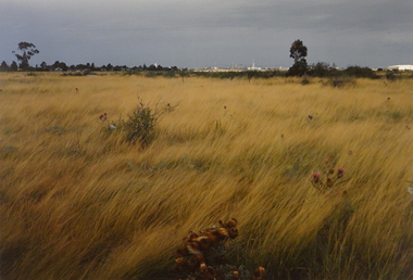
... Derrimut Grasslands - behind the Huntsman Chemical Complex - AR0015 and AR0035...Derrimut, Western Suburbs Melbourne, Victoria, Australia...Brimbank City Council Art Collection The Hunt Club Community Arts Centre 775 Ballarat Road Deer Park melbourne Local Scene Derrimut Grasslands - behind the Huntsman Chemical Complex - AR0015 and AR0035 Looking west towards the Huntsman chemical complex & City West Sunshine Photograph Robert Pointon ...Local SceneDerrimut Grasslands - behind the Huntsman Chemical Complex - AR0015 and AR0035 -
 Sunshine and District Historical Society Incorporated
Photograph - Derrimut Photographs 2021, John Alchin, 2021
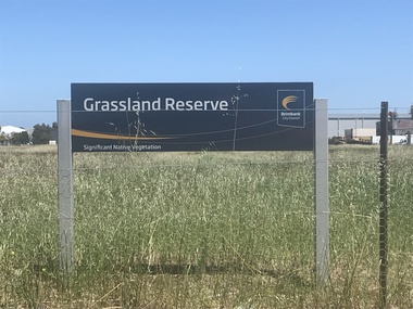
... Derrimut...These photographs provide a visual record of assorted buildings, street views, and notable locations throughout Derrimut in 2021....Parramount Grasslands Reserve Derrimut 2021 Photo 01.JPG...Derrimut Parramount Grassland Parramount Grasslands Reserve Derrimut 2021 Photo 01.JPG Collection of digital photographs Photograph Derrimut Photographs 2021 John Alchin ...These photographs provide a visual record of assorted buildings, street views, and notable locations throughout Derrimut in 2021.These photographs provide a visual chronicle of assorted buildings, street views, and notable locations throughout Derrimut in 2021.Parramount Grasslands Reserve Derrimut 2021 Photo 01.JPGderrimut, parramount grassland -
 Sunshine and District Historical Society Incorporated
Photograph - Derrimut - Service Station Photographs, John Alchin, 2026
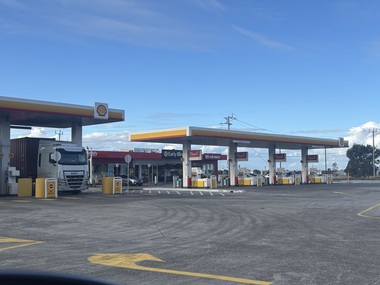
... ...Derrimut...Collection of photographs of current and former service stations in the Derrimut area....Derrimut Road 60 Derrimut - 7-Eleven Service Station 2026.JPG 5871.03 - Foleys Road 2 Derrimut - United Petroleum Service Station And Pie Face 2026.JPG 5871.04 - Fitzgerald Road 405 Derrimut - Pacific Petroleum Service Station 2026.JPG...Collection of photographs of current and former service stations in the Derrimut area. Service Station Derrimut Foleys Road Fitzgerald Road Mt. ...Collection of photographs of current and former service stations in the Derrimut area.5871.01 - Fitzgerald Road 285 Derrimut - Shell Reddy Express 2026.JPG 5871.02 - Mt. Derrimut Road 60 Derrimut - 7-Eleven Service Station 2026.JPG 5871.03 - Foleys Road 2 Derrimut - United Petroleum Service Station And Pie Face 2026.JPG 5871.04 - Fitzgerald Road 405 Derrimut - Pacific Petroleum Service Station 2026.JPGservice station, derrimut, foleys road, fitzgerald road, mt. derrimut road -
 Sunshine and District Historical Society Incorporated
Photograph - Derrimut Photographs 2023, John Alchin, 2023
... Derrimut...These photographs provide a visual record of assorted buildings, street views, and notable locations throughout Derrimut in 2023....5589.01 - Mt Derrimut Golf And Community Club 2023 Photo 01.JPG...Derrimut Mt. Derrimut Golf and Community club 5589.01 - Mt Derrimut Golf And Community Club 2023 Photo 01.JPG Collection of digital photographs Photograph Derrimut Photographs 2023 John Alchin ...These photographs provide a visual record of assorted buildings, street views, and notable locations throughout Derrimut in 2023.These photographs provide a visual chronicle of assorted buildings, street views, and notable locations throughout Derrimut in 2023.5589.01 - Mt Derrimut Golf And Community Club 2023 Photo 01.JPGderrimut, mt. derrimut golf and community club -
 Uniting Church Archives - Synod of Victoria
undated
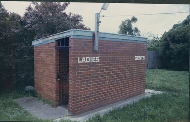
... The Methodist (later Uniting) Church in Derrimut St. opened on 15 December 1928....Colour photograph of the brick toilet block at Derrimut St. Albion....Uniting Church Archives - Synod of Victoria 54 Serrell Street Malvern East melbourne The Methodist (later Uniting) Church in Derrimut St. opened on 15 December 1928. Methodist Church, Uniting Church, Derrimut St. ...The Methodist (later Uniting) Church in Derrimut St. opened on 15 December 1928.Colour photograph of the brick toilet block at Derrimut St. Albion.methodist church, uniting church, derrimut st. albion -
 Uniting Church Archives - Synod of Victoria
Photograph, undated
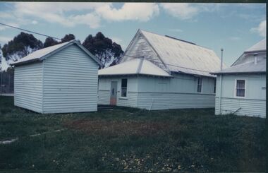
... The Methodist (later Uniting) Church in Derrimut St. opened on 15 December 1928....Colour photograph of the hall and storeroom at the rear of Derrimut St. Albion....Uniting Church Archives - Synod of Victoria 54 Serrell Street Malvern East melbourne The Methodist (later Uniting) Church in Derrimut St. opened on 15 December 1928. methodist church, uniting church, derrimut st. albion Albion Hall Colour photograph of the hall and storeroom at the rear of Derrimut St. ...The Methodist (later Uniting) Church in Derrimut St. opened on 15 December 1928.Colour photograph of the hall and storeroom at the rear of Derrimut St. Albion.methodist church, uniting church, derrimut st. albion, albion hall -
 Uniting Church Archives - Synod of Victoria
Photograph, undated
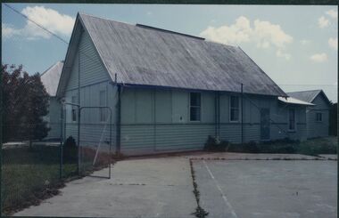
... The Methodist (later Uniting) Church in Derrimut St. opened on 15 December 1928....Colour photograph of the hall and tennis court at Derrimut St. Albion....Uniting Church Archives - Synod of Victoria 54 Serrell Street Malvern East melbourne The Methodist (later Uniting) Church in Derrimut St. opened on 15 December 1928. methodist church, uniting church, derrimut st. albion albion hall tennis court Colour photograph of the hall and tennis court at Derrimut St. ...The Methodist (later Uniting) Church in Derrimut St. opened on 15 December 1928.Colour photograph of the hall and tennis court at Derrimut St. Albion.methodist church, uniting church, derrimut st. albion, albion hall, tennis court -
 Sunshine and District Historical Society Incorporated
Archive - Truganina & Derrimut
... ... Derrimut...Truganina & Derrimut|A History of Truganina by George F Green 1935|Farms of the district|Families of the district...Typed notes A history of Truganina by Geo F Green 1935|Newspaper article The Sun 19 August 1973 Truganini|Handwritten notes 7 December Map of historic buildings roads drainage lines from Frances Overmars|Handwritten notes Alberts Plan Compiled by Albert James Evans who was born 6 April 1916|Typed notes Ancestry For Sarah and James Tout 1879 and Edward and Marion Elizabeth Richards 1890 and Annie and William Mitchell 1882 and Louisa and George and Elizabeth and John Opie 1871 and Charles and Maria Blackman 1878 and James and Margaret Rose 1875 and John Doherty and Jane Evans 1869 and William Doherty and Fanny Rebecca Scales 1867 and Jane Elizabeth and James Henry Evans 1867 and Louisa and William Cherry 1869|Extract The Plains of Iramoo by Esther Murray|Newspaper article The Sun 19 August1978 Truganini 98 years in a museum|Newspaper article Wandering around Werribee|Newspaper article The Western Times 19 March 1986 Wandering around Werribee|Handwritten notes Ancestry for Elizabeth Doherty Conner|Photocopy of map Tarneit Deutgam Derrimut Werribee...Truganina Derrimut Typed notes A history of Truganina by Geo F Green 1935|Newspaper article The Sun 19 August 1973 Truganini|Handwritten notes 7 December Map of historic buildings roads drainage lines from Frances Overmars|Handwritten notes Alberts Plan Compiled by Albert James Evans who was born 6 April 1916|Typed notes Ancestry For Sarah and James Tout 1879 and Edward and Marion Elizabeth Richards 1890 and Annie and William Mitchell 1882 and Louisa and George and Elizabeth and John Opie 1871 and Charles and Maria Blackman 1878 and James and Margaret Rose 1875 and John Doherty and Jane Evans 1869 and William Doherty and Fanny Rebecca Scales 1867 and Jane Elizabeth and James Henry Evans 1867 and Louisa and William Cherry 1869|Extract The Plains of Iramoo by Esther Murray|Newspaper article The Sun 19 August1978 Truganini 98 years in a museum|Newspaper article Wandering around Werribee|Newspaper article The Western Times 19 March 1986 Wandering around Werribee|Handwritten notes Ancestry for Elizabeth Doherty Conner|Photocopy of map Tarneit Deutgam Derrimut Werribee Truganina & Derrimut|A History of Truganina by George F Green 1935|Farms of the district|Families of the district Archive Truganina & Derrimut ...Typed notes A history of Truganina by Geo F Green 1935|Newspaper article The Sun 19 August 1973 Truganini|Handwritten notes 7 December Map of historic buildings roads drainage lines from Frances Overmars|Handwritten notes Alberts Plan Compiled by Albert James Evans who was born 6 April 1916|Typed notes Ancestry For Sarah and James Tout 1879 and Edward and Marion Elizabeth Richards 1890 and Annie and William Mitchell 1882 and Louisa and George and Elizabeth and John Opie 1871 and Charles and Maria Blackman 1878 and James and Margaret Rose 1875 and John Doherty and Jane Evans 1869 and William Doherty and Fanny Rebecca Scales 1867 and Jane Elizabeth and James Henry Evans 1867 and Louisa and William Cherry 1869|Extract The Plains of Iramoo by Esther Murray|Newspaper article The Sun 19 August1978 Truganini 98 years in a museum|Newspaper article Wandering around Werribee|Newspaper article The Western Times 19 March 1986 Wandering around Werribee|Handwritten notes Ancestry for Elizabeth Doherty Conner|Photocopy of map Tarneit Deutgam Derrimut Werribeetruganina, derrimut -
 Uniting Church Archives - Synod of Victoria
Photograph, undated
... The Methodist (later Uniting) Church in Derrimut St. opened on 15 December 1928. The Church is now known as The Good Shepherd Christian Church (Assemblies of God)....Colour photograph of a dwelling, church and hall located at 32 Derrimut St. Albion. ...Uniting Church Archives - Synod of Victoria 54 Serrell Street Malvern East melbourne The Methodist (later Uniting) Church in Derrimut St. opened on 15 December 1928. The Church is now known as The Good Shepherd Christian Church (Assemblies of God). methodist church, uniting church, derrimut st. albion parsonage Good Shepherd Christian Church Colour photograph of a dwelling, church and hall located at 32 Derrimut St. ...The Methodist (later Uniting) Church in Derrimut St. opened on 15 December 1928. The Church is now known as The Good Shepherd Christian Church (Assemblies of God).Colour photograph of a dwelling, church and hall located at 32 Derrimut St. Albion. methodist church, uniting church, derrimut st. albion, parsonage, good shepherd christian church -
 Uniting Church Archives - Synod of Victoria
Photograph, undated
... The Methodist (later Uniting) Church in Derrimut St. opened on 15 December 1928. The Church is now known as The Good Shepherd Christian Church (Assemblies of God)....Colour photograph of the Albion Church and hall located at 32 Derrimut St. Albion. ...Uniting Church Archives - Synod of Victoria 54 Serrell Street Malvern East melbourne The Methodist (later Uniting) Church in Derrimut St. opened on 15 December 1928. The Church is now known as The Good Shepherd Christian Church (Assemblies of God). methodist church, uniting church, derrimut st. albion parsonage good shepherd christian church Colour photograph of the Albion Church and hall located at 32 Derrimut St. ...The Methodist (later Uniting) Church in Derrimut St. opened on 15 December 1928. The Church is now known as The Good Shepherd Christian Church (Assemblies of God).Colour photograph of the Albion Church and hall located at 32 Derrimut St. Albion. methodist church, uniting church, derrimut st. albion, parsonage, good shepherd christian church -
 Uniting Church Archives - Synod of Victoria
Photograph, undated
... The Methodist (later Uniting) Church in Derrimut St. opened on 15 December 1928....Colour photograph of a weatherboard house and garage located at 32 Derrimut St. Albion. Possibly the parsonage for the Methodist minister....Uniting Church Archives - Synod of Victoria 54 Serrell Street Malvern East melbourne The Methodist (later Uniting) Church in Derrimut St. opened on 15 December 1928. methodist church, uniting church, derrimut st. albion parsonage Colour photograph of a weatherboard house and garage located at 32 Derrimut St. ...The Methodist (later Uniting) Church in Derrimut St. opened on 15 December 1928.Colour photograph of a weatherboard house and garage located at 32 Derrimut St. Albion. Possibly the parsonage for the Methodist minister.methodist church, uniting church, derrimut st. albion, parsonage -
 Sunshine and District Historical Society Incorporated
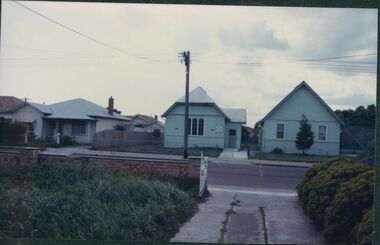
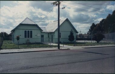
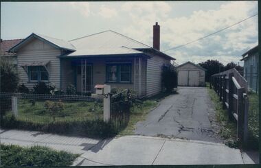
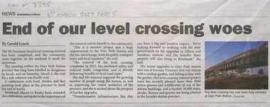
Article - Station Road - Mt. Derrimut Road Deer Park Level Crossing Removal
... Collection of newspaper articles on the Station Road - Mt. Derrimut Road Deer Park Level Crossing Removal...3345.01 - Station Road - Mt. Derrimut Road Deer Park Level Crossing Removal End Of Our Level Crossing Woes.jpg 3345.02 - Station Road - Mt. ...Derrimut Road Deer Park Level Crossing Removal ...For many years the level crossing at Deer Park held at the ever increasing traffic in the area. It was also the scene of a number of level crossing accidents. The project also built a new station.3345.01 - Station Road - Mt. Derrimut Road Deer Park Level Crossing Removal End Of Our Level Crossing Woes.jpg 3345.02 - Station Road - Mt. Derrimut Road Deer Park Level Crossing Removal What A Train Wreck.jpg 3345.03 - Station Road - Mt. Derrimut Road Deer Park Level Crossing Removal Mark Knight Cartoon.jpg 3345.04 - Station Road - Mt. Derrimut Road Deer Park Level Crossing Removal - Level Crossing Will Be Gone By July 2023.jpg 3345.05 - Station Road - Mt. Derrimut Road Deer Park Level Crossing Removal - Dear Park Station Wins National Landscape Award.jpgstation road , mt. derrimut road, deer park, railway, railway station, deer park railway station -
 Sunshine and District Historical Society Incorporated
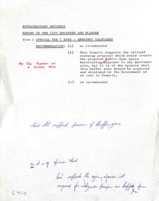
Administrative record - City of Sunshine - Commissioner Mr Alexander Alex George Gillon Collection 1976 - 1982 - Extraordinary business 8th May 1979, City of Sunshine, 8th May 1979
... Derrimut...Proposed changes in Zoning Derrimut Area...Derrimut Proposed changes in Zoning Derrimut Area Foolscap sized document. ...Proposed changes in Zoning Derrimut Areaderrimut -
 Sunshine and District Historical Society Incorporated
Letter - City of Sunshine - Commissioner Mr Alexander Alex George Gillon Collection 1976 - 1982 - Extraordinary business 15th April 1980, Victorian Government Minister for Planning, 6th March 1979
... Derrimut...Planning Special Use 7 Zone Derrimut...Derrimut Planning Special Use 7 Zone Derrimut Foolscap sized document. ...Planning Special Use 7 Zone Derrimutderrimut -
 Sunshine and District Historical Society Incorporated
Photograph - Mt Derrimut stone farm building
... Mt Derrimut stone farm building...Photograph of the Mt Derrimut stone farm building Deer Park Depicts type of building erected and made generally of blue stone blocks Building is thought to date back to the 1850s and 1860s when Richard and Septimus Morton developed a shorthorn cattle stud This picture appears in the publication Glimpses of early Sunshine...Mt. Derrimut Deer Park Building Photograph of the Mt Derrimut stone farm building Deer Park Depicts type of building erected and made generally of blue stone blocks Building is thought to date back to the 1850s and 1860s when Richard and Septimus Morton developed a shorthorn cattle stud This picture appears in the publication Glimpses of early Sunshine Mt Derrimut stone farm building Photograph Mt Derrimut stone farm building ...Photograph of the Mt Derrimut stone farm building Deer Park Depicts type of building erected and made generally of blue stone blocks Building is thought to date back to the 1850s and 1860s when Richard and Septimus Morton developed a shorthorn cattle stud This picture appears in the publication Glimpses of early Sunshinemt. derrimut, deer park, building -
 Sunshine and District Historical Society Incorporated
Map - Map of Derrimut, County of Bourke, Department of Lands and Survey, no date
... Derrimut...Map of Derrimut, County of Bourke (block owners) Sheet 2. ...Derrimut County of Bourke Map Map of Derrimut, County of Bourke (block owners) Sheet 2. ...derrimut, county of bourke, map -
 Sunshine and District Historical Society Incorporated
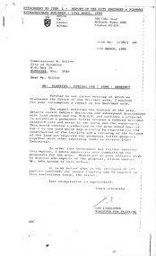
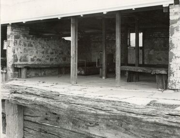
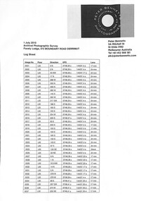
Archive - Foxely Lodge Foundry 472 Boundary Road Derrimut Photographic Survey, Bennetts, Peter, July, 2010
... ... Derrimut...1462.01 - Foxely Lodge Foundry 472 Boundary Road Derrimut - Log Sheet 1462.02 - Foxely Lodge Foundry 472 Boundary Road Derrimut - Site Plan With GPS Positions 1462.03 - Foxely Lodge Foundry 472 Boundary Road Derrimut - Contact Sheet 1 1462.03 - Foxely Lodge Foundry 472 Boundary Road Derrimut - Contact Sheet 2 1462.03 - Foxely Lodge Foundry 472 Boundary Road Derrimut - Contact Sheet 3 1462.03 - Foxely Lodge Foundry 472 Boundary Road Derrimut - Contact Sheet 4 1462.04 - Foxely Lodge Foundry 472 Boundary Road Derrimut - CD...DVD with photos and note from Sue Fittan Town Planing Brimbank City Council Foxely Lodge Foundry Boundary Road Derrimut 1462.01 - Foxely Lodge Foundry 472 Boundary Road Derrimut - Log Sheet 1462.02 - Foxely Lodge Foundry 472 Boundary Road Derrimut - Site Plan With GPS Positions 1462.03 - Foxely Lodge Foundry 472 Boundary Road Derrimut - Contact Sheet 1 1462.03 - Foxely Lodge Foundry 472 Boundary Road Derrimut - Contact Sheet 2 1462.03 - Foxely Lodge Foundry 472 Boundary Road Derrimut - Contact Sheet 3 1462.03 - Foxely Lodge Foundry 472 Boundary Road Derrimut - Contact Sheet 4 1462.04 - Foxely Lodge Foundry 472 Boundary Road Derrimut - CD Plastic folder containing plan pictures log sheet and DVD Archive Foxely Lodge Foundry 472 Boundary Road Derrimut Photographic Survey Bennetts, Peter ...DVD with photos and note from Sue Fittan Town Planing Brimbank City Council1462.01 - Foxely Lodge Foundry 472 Boundary Road Derrimut - Log Sheet 1462.02 - Foxely Lodge Foundry 472 Boundary Road Derrimut - Site Plan With GPS Positions 1462.03 - Foxely Lodge Foundry 472 Boundary Road Derrimut - Contact Sheet 1 1462.03 - Foxely Lodge Foundry 472 Boundary Road Derrimut - Contact Sheet 2 1462.03 - Foxely Lodge Foundry 472 Boundary Road Derrimut - Contact Sheet 3 1462.03 - Foxely Lodge Foundry 472 Boundary Road Derrimut - Contact Sheet 4 1462.04 - Foxely Lodge Foundry 472 Boundary Road Derrimut - CDfoxely lodge foundry, boundary road, derrimut -
 Sunshine and District Historical Society Incorporated
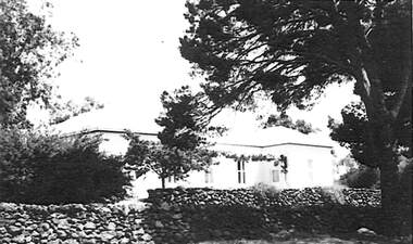
Photograph - Mt Derrimut homestead Deer Park owner Mr James Howatson
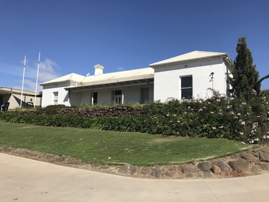
... Mt Derrimut homestead Deer Park owner Mr James Howatson...Photograph of the Mt Derrimut homestead Deer Park House was built by the owner Mr James Howatson in approximately 1883 to 1884 Howatson was a gentlemen sheep farmer until his death in 1897 His wife Sarah Jane was well known for her interest in the local school Deer Park No 1434...Mt. Derrimut Deer Park House Photograph of the Mt Derrimut homestead Deer Park House was built by the owner Mr James Howatson in approximately 1883 to 1884 Howatson was a gentlemen sheep farmer until his death in 1897 His wife Sarah Jane was well known for her interest in the local school Deer Park No 1434 Mt Derrimut homestead Deer Park owner Mr James Howatson Photograph Mt Derrimut homestead Deer Park owner Mr James Howatson ...Photograph of the Mt Derrimut homestead Deer Park House was built by the owner Mr James Howatson in approximately 1883 to 1884 Howatson was a gentlemen sheep farmer until his death in 1897 His wife Sarah Jane was well known for her interest in the local school Deer Park No 1434mt. derrimut, deer park, house -
 Sunshine and District Historical Society Incorporated
Administrative record - City of Sunshine - Commissioner Mr Alexander Alex George Gillon Collection 1976 - 1982 - Extraordinary business 15th April 1980, City of Sunshine, 15th April 1979
... ...Derrimut...Special Use 7 Zone Derrimut Saleyards...Derrimut Saleyards Boundary Road Fitzgerald Road Derrimut Special Use 7 Zone Derrimut Saleyards Foolscap sized document. ...Special Use 7 Zone Derrimut Saleyardsderrimut saleyards, boundary road, fitzgerald road, derrimut -
 Sunshine and District Historical Society Incorporated
Administrative record - City of Sunshine - Commissioner Mr Alexander Alex George Gillon Collection 1976 - 1982 - Extraordinary Business Extract No Date 1980, City of Sunshine, 1980
... ...Derrimut...Special Use 7 Zone Derrimut Saleyards...Derrimut Saleyards Boundary Road Fitzgerald Road Derrimut Special Use 7 Zone Derrimut Saleyards Foolscap sized document. ...Special Use 7 Zone Derrimut Saleyardsderrimut saleyards, boundary road, fitzgerald road, derrimut -
 Sunshine and District Historical Society Incorporated
Administrative record - City of Sunshine - Commissioner Mr Alexander Alex George Gillon Collection 1976 - 1982 - Committee meetings reports 8th May 1979, City of Sunshine, 8th May 1979
... ...Derrimut...Survey of residents of Glengala Estate September 1978 Planning Permit Restaurant Main Road West Proposed Changes in Zoning Derrimut Area...Main Road West St. Albans Derrimut Survey of residents of Glengala Estate September 1978 Planning Permit Restaurant Main Road West Proposed Changes in Zoning Derrimut Area Foolscap sized document. ...Survey of residents of Glengala Estate September 1978 Planning Permit Restaurant Main Road West Proposed Changes in Zoning Derrimut Areamain road west, st. albans, derrimut -
 Sunshine and District Historical Society Incorporated
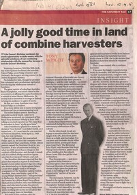
Article - A Jolly good Time In Land Of Combine Harvesters & Prince Phillip, The Age, 4/06/2011 12:00:00 AM
... Newspaper article on Prince Phillip time at the Derrimut Hotel and Mary & Roma Fowler...Prince Phillip Derrimut Hotel Sun Crescent Sunshine Newspaper Age 4th June 2011 A jolly good time in land of combine harvesters Newspaper article on Prince Phillip time at the Derrimut Hotel and Mary & Roma Fowler Article A Jolly good Time In Land Of Combine Harvesters & Prince Phillip The Age Wright, Tony ...Newspaper Age 4th June 2011 A jolly good time in land of combine harvestersprince phillip, derrimut hotel, sun crescent, sunshine -
 Sunshine and District Historical Society Incorporated
Administrative record - City of Sunshine - Commissioner Mr Alexander Alex George Gillon Collection 1976 - 1982 - Attachments for the ordinary meeting 14th October 1980, City of Sunshine, 14th October 1980
... ...Derrimut...Supplementary Valuations for the Western and River Wards of the City of Sunshine Town Planning Appeal Tribunal Protean Appeal Fitzgerald Road and Boundary Road Derrimut Statement of Objections to Grant Permit 121 South Road Braybrook...Protean Fitzgerald Road Boundary Road Derrimut South Road Braybrook Supplementary Valuations for the Western and River Wards of the City of Sunshine Town Planning Appeal Tribunal Protean Appeal Fitzgerald Road and Boundary Road Derrimut Statement of Objections to Grant Permit 121 South Road Braybrook Foolscap sized document. ...Supplementary Valuations for the Western and River Wards of the City of Sunshine Town Planning Appeal Tribunal Protean Appeal Fitzgerald Road and Boundary Road Derrimut Statement of Objections to Grant Permit 121 South Road Braybrookprotean, fitzgerald road, boundary road, derrimut, south road, braybrook -
Sunshine and District Historical Society Incorporated
Map - Geological survey map of Derrimut, Maribyrnong , Kororoit and Jorrk
... Geological survey map of Derrimut, Maribyrnong , Kororoit and Jerk. Prepared by the Depart. of Crown Lands & Survey....Map Geological survey map of Derrimut, Maribyrnong , Kororoit and Jorrk. ... -
 Sunshine and District Historical Society Incorporated
Letter - City of Sunshine - Commissioner Mr Alexander Alex George Gillon Collection 1976 - 1982 - Proposed Relocation Of Saleyards At Derrimut, Shire of Werribee, 30th November 1976
... Proposed Relocation of Saleyards at Derrimut...City of Sunshine Alexander "Alex" George Gillon Proposed Relocation of Saleyards at Derrimut Foolscap sized document. Letter City of Sunshine - Commissioner Mr Alexander Alex George Gillon Collection 1976 - 1982 - Proposed Relocation Of Saleyards At Derrimut Shire of Werribee ...Proposed Relocation of Saleyards at Derrimut city of sunshine, alexander "alex" george gillon